Ecoregions of Canada

Source: NASA
Ecoregions of Countries Collection ![]()
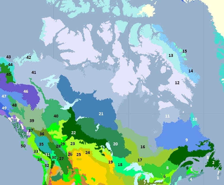
Canada has 50 ecoregions that occur entirely or partly within its borders as listed below and shown in the accompanying figure:
Contents
- 1 South Avalon-Burin oceanic barrens
- 2 Eastern Canadian forests
- 3 Newfoundland Highland forests
- 4 New England-Acadian forests
- 5 Gulf of St. Lawrence lowland forests
- 6 Eastern Great Lakes lowland forests
- 7 Southern Great Lakes forests
- 8 Eastern forest-boreal transition
- 9 Eastern Canadian Shield taiga
- 10 Torngat Mountain tundra
- 11 Low Arctic tundra
- 12 Middle Arctic tundra
- 13 High Arctic tundra
- 14 Davis Highlands tundra
- 15 Baffin coastal tundra
- 16 Southern Hudson Bay taiga
- 17 Central Canadian Shield forests
- 18 Western Great Lakes forests
- 19 Northern tall grasslands
- 20 Midwestern Canadian Shield forests
- 21 Northern Canadian Shield taiga
- 22 Mid-Continental Canadian forests
- 23 Canadian Aspen forests and parklands
- 24 Northern mixed grasslands
- 25 Northern short grasslands
- 26 Montana Valley and Foothill grasslands
- 27 North Central Rockies forests
- 28 Alberta Mountain forests
- 29 Alberta-British Columbia foothills forests
- 30 Okanagan dry forests
- 31 Cascade Mountains leeward forests
- 32 Puget lowland forests
- 33 British Columbia mainland coastal forests
- 34 Central Pacific coastal forests
- 35 Fraser Plateau and Basin complex
- 36 Central British Columbia Mountain forests
- 37 Northern transitional alpine forests
- 38 Pacific Coastal Mountain icefields and tundra
- 39 Northern Cordillera forests
- 40 Muskwa-Slave Lake forests
- 41 Northwest Territories taiga
- 42 Arctic Coastal tundra
- 43 Arctic Foothills tundra
- 44 Brooks-British Range tundra
- 45 Interior Alaska-Yukon lowland taiga
- 46 Ogilvie-MacKenzie alpine tundra
- 47 Interior Yukon-Alaska alpine tundra
- 48 Yukon Interior dry forests
- 49 Alaska-St. Elias Range tundra
- 50 Queen Charlotte Islands
- 51 Context
- 52 World Heritage Sites
- 53 Marine Ecosystems
South Avalon-Burin oceanic barrens
This small ecoregion is comprised of the outer headlands of narrow peninsulas in eastern Newfoundland. These headlands are exposed to high winds, cool temperatures and salt spray for most of the year.
The ecoregion supports dense carpets of moss and fruticose lichen, along with closed, low-growing ericaceous shrubs. Dwarf krummholz of balsam fir (Abies balsamea) occurs on some upland sites, and the moss-heath of this region is unique to North America.
Characteristic wildlife include caribou (Rangifer tarandus), willow ptarmigan (Lagopus lagopus), and many seabird species, including one of the world’s largest Northern gannet (Morus bassanus) colonies, situated at Cape St. Mary’s.
Eastern Canadian forests
 Walker Lake, near Port Cartier, Quebec, Canada Photograph by Lynda Dredge/Used with permission of the Geological Survey of Canada, Natural Resources Canada The Eastern Canadian forests characterize forested land in eastern Quebec, much of Newfoundland, and disjunct occurrences in the highlands of New Brunswick, and Cape Breton Island, Nova Scotia.
The boreal forest in this bioregion is characterized by a mix of balsam fir (Abies balsamea) and black spruce (Picea mariana). Balsam fir dominates to the east as a result of the maritime influence of the Atlantic.
Approximately 40 percent of this ecoregion remains as intact habitat. The majority of this occurs along the northern portions of the ecoregion in Quebec. Parts of the ecoregion in the Gaspé, northern New Brunswick and Newfoundland have been heavily altered by a long history of human settlement. Some areas have been extensively logged and not returned to their original vegetation communities, often remaining as barrens or shrublands. Mining in some localized areas has also resulted in habitat loss (e.g. Matamec, Quebec).
Newfoundland Highland forests
 Gros Morne NP, Newfoundland, Canada Photograph by Geological Survey of Canada The Newfoundland highland forests ecoregion lies entirely within the island of Newfoundland. It is distinguished from the Eastern Canadian Forests by higher elevational range and rugged topography.
The boreal forest in this ecoregion is characterized by dwarf, open and sometimes closed cover patches of black spruce (Picea mariana) and balsam fir (Abies balsamea) alternating with communities of dwarf kalmia (Kalmia polifolia) and mosses. Exposed sites support mixed evergreen and deciduous shrubs.
This ecoregion contains the northernmost extension of the Appalachian Mountain system in North America.
It is estimated that 80-90 percent of the ecoregion remains as intact habitat. Most areas above the tree line have only been impacted as the result of a few transmission corridors, mineral exploration and extraction, and domestic wood harvesting at the middle and lower elevations.
New England-Acadian forests
The New England-Acadian forests form a mosaic of forest types and nonforest [[habitat]s] covering the Eastern Townships and Beauce [[region]s] of Quebec, approximately 50 percent of New Brunswick, most of Nova Scotia, northwestern Massachusetts and extreme northwestern Connecticut, and all but the southwestern corner of Maine, the Champlain Valley of Vermont and the coastal plain of New Hampshire.
Now increasingly forested, parts of the landscape in this ecoregion have changed dramatically over the past 350 years. Once covered by primeval forest, farmers cleared the land for agriculture at such a pace that by the middle of the 19th century farm crops or pastures covered nearly three-quarters of the arable land in southern and central New England. One hundred years later, forests again blanketed 75 percent of New England–the result of an era of farm abandonment brought on by the opening of richer farmland to the west, the building of railroads, the Civil War, and even the California Gold Rush.
Gulf of St. Lawrence lowland forests
The Gulf of St. Lawrence ecoregion includes all of Prince Edward Island, Isles de la Madeleine, Quebec, most of east-central New Brunswick, the Annapolis Valley and the Northumberland Strait coast of Nova Scotia.
The closed mixedwood forests of this ecoregion are strongly influenced by a maritime climate where warm summers allow for good growth of hardwoods, which are often mixed with red spruce (Picea rubens) and balsam fir (Abies balsamea). Eastern hemlock (Tsuga canadensis) and eastern white pine (Pinus strobus) are found in the Maritime Lowlands of New Brunswick and the Annapolis-Minas Lowlands of Nova Scotia. Sugar maple (Acer saccharum), yellow birch (Betula allegheniensis) and beech (Fagus grandifolia) are more common on well-drained, higher elevation areas. Bogs and fens are significant in the Minas Lowlands, while other wet sites support white elm (Ulmus americana), black ash (Fraxinus nigra), and red maple (A. rubrum). The original mixedwood forest of PEI was characterized by red oak (Quercus rubra), sugar maple, yellow birch and beech while abandoned fields are returning to forests of white spruce (P. glauca). Although warm summers also characterize the climate of Iles-de-la-Madeleine, poor drainage results in a conifer-dominated forest of black spruce (P. mariana) and balsam fir.
It is estimated that only about 3 percent of this ecoregion can be considered as intact habitat. More than 75 percent is considered to be heavily altered.
Eastern Great Lakes lowland forests
This ecoregion includes lowland areas of New York and Vermont surrounding the Adirondacks, portions of Quebec along the St. Lawrence River, and much of southern Ontario between Lake Ontario and Lake Huron/Georgian Bay. Suburban development and pollution of the St. Lawrence have severely harmed natural areas here, and less than 5 percent of the ecoregion remains as intact habitat.
Southern Great Lakes forests
This ecoregion covers much of the industrial heartland of North America, including southern Michigan, much of Ohio and Indiana, extreme southwestern Ontario, including the lowlands of the south of Lake Ontario in Ontario and western New York State. The area is so heavily populated and developed that essentially no large blocks of natural habitat remains.
Eastern forest-boreal transition
 Algoma Highlands, Ontario, Canada Photograph by M. O'Connor / CPAWS This ecoregion includes most of the southern Canadian Shield in Ontario and Quebec. The shield, in fact, principally defines the southern boundaries of this ecoregion. It lies north and west of the St. Lawrence Lowlands except for a disjunct section comprised of the Adirondack Mountains in upper New York State.
The characteristic mixed forests of this ecoregion are distinct from the predominantly deciduous forests to the south and the cooler boreal forests to the north. In the northern reaches and in the Lac Temiscamingue area, the forests transition into a more predominantly boreal forest characteristic of ecoregions to the north, although on warmer, better drained sites, deciduous species dominate.
It is estimated that only 10 percent of the ecoregion remains as intact habitat. Much of the area has been highly fragmented by forestry activities, settlements, summer homes and cottages, ski facilities, and agriculture.
Eastern Canadian Shield taiga
 Near Schefferville, Quebec, Canada Photograph by Lynda Dredge/Used with permission of the Geological Survey of Canada, Natural Resources Canada This large ecoregion occupies a significant part of northern Quebec and most of Labrador, stretching from Hudson and James Bay to the west, southern Ungava Bay to the north, and the Atlantic Ocean to the east.
Vegetation consists of open, stunted stands of black spruce (Picea mariana) (climax species) and tamarack, with secondary quantities of white spruce (P. glauca) and dwarf birch (Betula spp.), willow (Salix spp.), ericaceous shrubs (Ericaceae), cottongrass (Eriophorum spp.), [[lichen]s] and moss. Poorly-drained sites support sedge (Carex spp.), Labrador tea (Ledum groenlandicum) cottongrass, and sphagnum moss (Sphagnum spp.). The northwestern boundary of this ecoregion is where the tree limit is reached in Quebec, and trembling aspen reaches its northern limit in the Mecatina River ecoregion in Labrador.
Approximately 95 percent of the [[ecoregion]’s] natural habitat remains intact. About 5 percent of the ecoregion is permanently flooded from hydro-electric projects.
Torngat Mountain tundra
 McCormick River valley, Newfoundland, Canada Photograph by Hazen Russell/Used with permission of the Geological Survey of Canada, Natural Resources Canada This ecoregion occupies the northernmost part of Labrador and the western slopes of the Torngat Mountains in Quebec. It is a mountainous region principally covered by arctic vegetation, although these gradually integrate with boreal elements towards the southern end of the region and in valleys/river corridors that penetrate the mountains.
The ecoregion is characterized by a sparse cover of lichen, moss, arctic sedge (Carex spp.), grass (Gramineae), and patches of arctic mixed evergreen and deciduous shrubs on sheltered, south-facing valley slopes. Unvegetated rock and tundra (arctic heath made up of lichens, mosses, and sedges) each comprise about 50 percent of the upland surfaces. White birch (Betula papyrifera)/willow (Salix spp.) thickets growing on less stable scree frequently form a transition zone between the tundra and the very open spruce forests. Arctic black spruce (Picea mariana) with mixed evergreen and deciduous shrubs, underlain by moss, is dominant on wetter sites.
Wildlife in the ecoregion is characterized mostly by small mammals, although the Torngat Mountains do provide seasonal habitat for polar bear (Ursus maritimus) and caribou (Rangifer tarandus). This ecoregion is home to the only global population of tundra-dwelling black bears (Ursus americanus) and completely encompasses the range of the Torngat caribou herd (approximately 10,000 animals). It also provides habitat for the southernmost denning of polar bears on the North American east coast. In addition, the coastal area of this ecoregion lies along the Atlantic migratory flyway.
Low Arctic tundra
 Near Coppermine River, Nunavut, Canada Photograph by Lynda Dredge/Used with permission of the Geological Survey of Canada, Natural Resources Canada This ecoregion covers a significant east to west expanse. Much of it falls within the mainland boundaries of the Northwest Territories, although it also includes part of Quebec. Specifically, it stretches from the Dease Arm Plain in its northwestern reaches, through the plains and lowlands of the central Northwest Territories, to the Ottawa and Belcher Islands in Hudson Bay and the southern and western sections of Southampton Island, to the central Ungava peninsula in northern Quebec.
The ecoregion is characterized by a continuous cover of shrubby tundra vegetation. Permafrost is continuous with low to high ice content, except for discontinuous permafrost in the Ottawa Islands ecoregion and Belcher Island ecoregion.
There is a great diversity of mammal species that inhabit this ecoregion. Notably, it is the major summer range and calving grounds of some of Canada’s largest caribou herds (Rangifer tarandus), barren-ground caribou in the west and woodland caribou in the east.
Middle Arctic tundra
 Cumberland Sound, Baffin Island, Nunavut, Canada Photograph by Govt. of the Northwest Territories The Middle Arctic tundra ecoregion is quite large in geographic extent, stretching from the Banks Island lowlands in the west to the eastern tip of Baffin Island in the east. Principally in the Northwest Territories, it includes a small portion of extreme northern Quebec.
Because of high winds, harsh climate, and shallow, poor soils, vegetation is sparse and dwarfed.
Significant ecological features of this ecoregion include: 80 percent of the world’s muskox population, including the highest density (Minto Inlet and Thompson valley), global range of Arctic island caribou (similar to Peary caribou but taxonomic designation unresolved), global range (with High Arctic Tundra) of high Arctic wolf (Canis lupus arctos), calving grounds for six caribou herds on Northwest Territories mainland and others on the islands, and Polar beardenning hotspots.
High Arctic tundra
 Near Nanisivik, Nunavut, Canada Photograph by Biz Agnew/ WWF This ecoregion encompasses most of the northern Arctic archipelago, including most of Axel Heiberg and Ellesmere Islands, a significant portion of Baffin Island, the majority of Somerset Island and all of the remaining Queen Elizabeth Islands.
Plant species must be very robust to survive in this ecoregion’s climate. In the north, clumps of moss, lichen, and cold-hardy vascular plants such as sedge (Carex spp.) and cottongrass (Eriophorum spp.) are the dominant vegetation. Arctic willow (Salix arctica) and Dryas spp. occur infrequently, and mixed, low-growing herbs like purple saxifrage (Saxifraga oppositifolia), Kobresia spp. and arctic poppy (Papaver radicadum) can sometimes be found at lower elevations.
Significant ecological features of this ecoregion include the global range of the endangered peary caribou (Rangifer tarandus ssp. pearyi), the global distribution of polar desert [[habitat]s] with globally unique species assemblages of plants, vertebrates and mammals. This is one of only two ecoregions ( Middle Arctic Tundra ) with viable [[population]s] of high Arctic wolves (Canis lupus arctos). The ecoregion also includes nesting sites for Ross’ gulls (Rhodostethis rosea) and ivory gulls (Pagophila eburnea).
Davis Highlands tundra
 Bylot Island, Nunavut, Canada Photograph by Geological Survey of Canada This ecoregion is comprised of the Baffin Mountains, an elevated belt of deeply dissected crystalline rocks that extend along the northeastern flank of Baffin and Bylot Islands. Ice-capped mountains reach 1525-2135 meters above sea level. Rugged topography distinguishes this ecoregion from the High Arctic Tundra ecoregion.
The dominant vegetation is a discontinuous cover of mosses, lichens, and cold-hardy vascular plants such as sedge (Carex spp.) and cotton grass (Eriophorum spp.).
Characteristic wildlife include arctic hare (Lepus acticus), arctic fox (Alopex lagopus), and caribou (Rangifer tarandus). Polar bears (Ursus maritimus) are common in coastal areas. Representative birds include king eider (Somateria spectabilis), rock ptarmigan (Lagopus mutus), northern fulmar (Fulmarus glacialis), plover (Charadrius spp. and Pluvialis spp.), hoary redpoll (Carduelis hornemanni) and snow bunting (Plectrophenax nivalis). Marine mammals include walrus (Odobenus rosmarus), seal (Phocidae) and a variety of whales (Cetacea).
Baffin coastal tundra
The ecoregion, characterized primarily as a [[coast]al plain], is situated on the central north coast of Baffin Island and is relatively small in area.
The ecoregion has a sparse vegetative cover of mixed low-growing herbs and shrubs, consisting of moss, purple saxifrage (Saxifraga oppositifolia), Dryas, arctic willow (Salix arctica), Kobresia, sedge (Carex spp.) and arctic poppy (Papaver radicadum). Wet sites can develop up to about 60 percent cover of wood rush (Luzula spp.), wire rush (Juncus spp.) and saxifrage (Saxifraga spp.), along with a nearly continuous cover of mosses.
Characteristic wildlife include arctic hare (Lepus arcticus), arctic fox (Alopex lagopus), lemming (Lemminae), and caribou (Rangifer tarandus). Polar bears (Ursus maritimus) are common in the [[coast]al areas]; a large proportion of the Northwest Territory/Greenland shared population of polar bears use this coastal ecoregion in summer. Representative birds include king eider (Somateria spectabilis), rock ptarmigan (Lagopus mutus), northern fulmar (Fulmarus glacialis), plover (Charadrius spp. and Pluvialis spp.), hoary redpoll (Carduelis hornemanni), and snow bunting (Plectrophenax nivalis).
Southern Hudson Bay taiga
The Southern Hudson Bay taiga ecoregion extends along the lowlands adjacent to Hudson Bay from Manitoba, though Ontario and into a small part of western Quebec next to James Bay. The islands in James Bay (under the jurisdiction of the Northwest Territories) also fall within this ecoregion. Approximately 80 percent of the ecoregion lies within Ontario.
Stunted black spruce and tamarack dominate the vegetation here. These trees become larger and more dense toward the south.
Characteristic wildlife species include caribou (Rangifer tarandus), snow goose (Chen caerulenscens), Canada goose (Branta canadensis) and snowshoe hare (Lepus americanus) throughout most of the ecoregion. [[Polar bear](Ursus maritimus)], arctic fox (Alopex lagopus), tundra swan (Cygnus columbianus), sea ducks, shorebirds, Beluga whale (Delphinapterus leucas), and seal (Phocidae) are found along the Hudson Bay coast.
Central Canadian Shield forests
 Wabakimi Provincial Park, Ontario, Canada Photograph by B. Petersen The Central Canadian Shield forestsecoregion occupies a U-shaped area stretching from the Ontario-Manitoba border in northwestern Ontario south and eastward to the north shore of Lake Superior and then northeastward into west central Quebec.
Black spruce is the climatic climax species in the north, as this area is dominated by coniferous forest. Fire occurs frequently, such that forest stands are composed of medium to tall closed stands of black spruce and jack pine (Pinus banksiana) with some paper birch (Betula papyrifera). South-facing slopes or warmer areas include greater proportions of quaking aspen (Populus tremuloides), white birch (Betula sp.), white spruce (Picea glauca), and balsam fir (Abies balsamea). Most of the south is dominated by mixed forest, characterized by white and black spruce (Picea mariana), balsam fir, jack pine trembling aspen and paper birch. Forest fires are an important natural disturbance in these coniferous forests.
Characteristic wildlife include moose (Alces alces), caribou (Rangifer tarandus), black bear (Ursus americanus), lynx (Lynx canadensis), snowshoe hare (Lepus americanus), wolf (Canis lupus), sharp-tailed grouse (Tympahuchus phasianellus), ruffed grouse (Bonasa umbellus), American black duck (Anas rubripes), and wood duck (Aix sponsa), as well as Canada goose (Branta canadensis) in the northern region, and hooded merganser (Lophodytes cucullatus) and pileated woodpecker (Dryocopus pileatus) in the west.
It is estimated that 40 percent or less of this ecoregion remains as intact habitat. Small parts of this ecoregion are heavily altered with some conversion to pasture, while more extensive areas have been significantly disturbed by large-scale, mechanized logging. More than 50 percent of this ecoregion has been logged and additional parts of the ecoregion are scheduled for logging in the near future.
Western Great Lakes forests
The Western Great Lakes forests stretch from northern Michigan and the Upper Peninsula through northern Wisconsin, much of northern Minnesota, and into the southern portion of northwestern Ontario and extreme southeastern Manitoba. Characteristic forests in this region are more closely identified with the warmer, more humid southeastern mixed forests, than with the colder, drier boreal regions to the north.
Characteristic wildlife in the Western Great Lakes forests include moose (Alces alces), black bear (Ursus americanus), wolf (Canis lupus), lynx (Lynx canadensis), snowshoe hare (Lepus americanus), white-tailed deer (Odocoileus virginianus), and woodchuck (Marmota monax). Bird species include ruffed grouse (Bonasa umbellus), hooded merganser (Lophodytes cucullatus), pileated woodpecker (Dryocopus pileatus), bald eagle (Haleaeetus leucocephalus), turkey vulture (Cathartes aura), herring gull (Larus argentatus), and waterfowl. American black duck (Anas rubripes) and wood duck (Aix sponsa) occur in the eastern part of the ecoregion.
Only 20 percent of the Western Great Lakes forests remains as intact habitat.
Northern tall grasslands
The Northern Tall Grasslands is the northernmost extension of the true tallgrass prairie in North America. It follows the Red River Valley from Lake Manitoba in Manitoba south into eastern North Dakota and western Minnesota.
As in the other tallgrass [[ecoregion]s], the dominant grass species in this ecoregion are big bluestem (Andropogon gerardii), switchgrass (Panicum virgatum) and Indian grass (Sorghastrum nutans). The richness of the herbaceous cover is less than in the other two tall grasslands. The ecoregion is transitional between the aspen (Populus spp.) parkland to the north and northwest, mixed grass prairie to the west and prairie-forest transitional ecoregions to the east. The tallgrass prairie is most dominant on well-drained, drier sites and is often mixed with quaking aspen (Populus tremuloides) and oak (Quercus macrocarpa) groves, and rough fescue grasslands.
Like other ecoregions of this section of North America, bison (Bison bison) and elk (Cervus elaphus) once roamed these tallgrass [[prairie]s], where they were hunted by the coyote (Canis latrans). These species are now gone, although bison are slowly being reintroduced to the area and wolves (Canis lupus) occasionally enter the ecoregion from the east. Common wildlife species in this ecoregion include white-tailed deer (Odocoileus virginianus), rabbit (Sylvilagus spp.), ground squirrel (Spermophilus spp.) and significant waterfowl [[population]s].
This is the northernmost grassland-savanna complex in eastern North America.
Approximately 5 percent of the ecoregion remains as intact habitat, mostly on former beach ridge sites that are comprised of coarse sands, droughty and less valuable for crop production, and along riparian corridors. Habitat loss is extensive in this ecoregion given the high rate of conversion to agriculture. More than 75 percent of the ecoregion is considered to be heavily altered.
Midwestern Canadian Shield forests
 Otter Rapids (lower half) on the Churchill River in Saskatchewan. Source: Wikimedia Commons The Midwestern Canadian Shield forests ecoregion covers much of northern Saskatchewan, north-central Manitoba (north and east of Lake Winnipeg) and a portion of northwestern Ontario.
A portion of this ecoregion (the Athabasca Plain and the Churchill River Upland) forms part of the continuous coniferous boreal forest that extends from northwestern Ontario to Great Slave Lake in the Northwest Territories. Forests of this ecoregion are dominated by stands of black spruce (Picea mariana) and jack pine (Pinus banksiana), with a shrub layer of ericaceous shrubs (Ericaceae) and a ground cover of moss and [[lichen]s].
Up to 80 percent of this ecoregion remains as intact habitat, although that number drops to an estimated 65 percent in Manitoba. The principal causes of habitat loss are forestry (rapidly expanding), mining (uranium, nickel, gold, copper) and flooding from hydro-electric development.
Northern Canadian Shield taiga
 South Knife Lake, Manitoba, Canada Photograph by Lynda Dredge/Used with permission of the Geological Survey of Canada, Natural Resources Canada This ecoregion covers a large area of the Northwest Territories, extreme northeastern Alberta, northern Saskatchewan, and northwestern Manitoba.
The limit of tree growth is reached along the northern boundaries of this ecoregion. The ecoregion as a whole constitutes the tundra and boreal transition zone. Vegetation consists of open, very stunted stands of black spruce (Picea mariana) and tamarack (Larix laricina), with secondary quantities of white spruce (Picea glauca) and ground cover of dwarf birch (Betula sp.), ericaceous shrubs (Ericaceae), cottongrass (Eriophorum spp.), lichen and moss.
This ecoregion represents nearly one quarter of the linear extent of the tree line in North America. Wolf denning is common along the treeline. The combination of forests and tundra in this ecoregion results in significant overlap of woodland and barren-gound caribou (Rangifer tarandus ssp. arcticus) herds. Major caribou herds include the Bathurst herd and the Beverley-Quaminirauq herds. This is perhaps the most frequented area in northwestern Canada for caribou in terms of their winter range.
Mid-Continental Canadian forests
 Wood Buffalo National Park, Alberta, Canada Photograph by C. Wallis The mid-continental Canadian forest ecoregion extends from southern Great Slave Lake in NWT to encompass most of northeastern Alberta, central Saskatchewan and parts of west-central Manitoba.
The ecoregion forms part of the continuous mid-boreal mixed coniferous and deciduous forest extending from northwestern Ontario to the foothills of the Rocky Mountains. The mixed coniferous and deciduous forest is characterized by medium to tall closed stands of quaking aspen (Populus tremuloides) and balsam poplar (Populus balsamifera) with white and black spruce (Picea glauca and P. mariana), and balsam fir (Abies balsamea) occurring in late successional stages.
The principal breeding range for whooping cranes (Grus americana) in North America is found within this ecoregion. The wetlands found here are of hemispheric significance to waterfowl migration, including many staging sites. The Cumberland delta-a very large wetland complex-is one such example.
Canadian Aspen forests and parklands
 South Block, Rumsey, British Columbia, Canada (Photograph by D. Poulton) This ecoregion stretches in an arc from the Manitoba/North Dakota border in the east to central Alberta in the west with a disjunct occurrence in northwestern Alberta crossing the British Columbia border in the Peace River area.
Vegetation in this ecoregion is characterized by a cover of quaking aspen with secondary quantities of balsam poplar, together with an understory of mixed herbs and tall shrubs. White spruce and balsam fir are the climax species, but are not well represented because of fires. Jack pine stands may be present on drier, sandy sites. Poorly drained sites are usually covered with sedges, willow, some black spruce, and tamarack . In the Turtle Mountain and Spruce woods areas, quaking aspen dominates with secondary quantities of balsam poplar, although white spruce and balsam fir are the climax species if fires do not occur frequently.
Characteristic wildlife include moose, white-tailed deer , black bear, wolf, beaver , coyote, marten, mink, red fox, snowshoe hare, northern pocket gopher, Franklin's ground squirrel (Citellus franklinii), sharp-tailed grouse, ruffed grouse, black-billed magpie, cormorant, gull, tern, American white pelican and many neotropical migrant bird species.
Of ecological significance, the Aspen Parkland and Forests ecoregion represents the most extensive boreal-grassland transition in the world. This ecoregion contains the northernmost breeding distribution for many warbler species and has some of the most productive and extensive waterfowl breeding habitat on the continent. White-tailed and black-tailed deer reach their northern continental limit here.
It is estimated that less than 10 percent of the natural habitat in this region remains intact. Of the 90 percent disturbed, most has been converted to agricultural cropland.
Northern mixed grasslands
The Northern Mixed Grasslands cross Alberta, Saskatchewan, and southern Manitoba in Canada, and run from North Dakota to northern Nebraska in the U.S. (United States), covering about 270,000 km2.
This ecoregion is arguably the most disturbed among all grassland ecoregions with only a few remnant patches remaining, none of which are considered to be intact. Conversion to agriculture has completely changed the landscape in an ecoregion that once supported large populations of bison (Bison bison). Restoration of representative examples of this ecoregion will be a major challenge.
Northern short grasslands
 Charles M. Russel NWR, Montana, USA Photograph by Rick Graetz/ USFWS The Northern short grasslands is the largest grassland ecoregion in North America, covering almost 640,000 km2. This ecoregion covers parts of southeastern Alberta and southwestern Saskatchewan, much of the area east of the Rocky Mountains, central and eastern Montana, western North and South Dakota, and northeastern Wyoming.
More than 85 percent of the ecoregion is now grazed by livestock or converted to dryland farming. In the Canadian portion, it is estimated that only about 2 percent of the ecoregion remains as natural, intact habitat. Considerable potential exists for habitat recovery in some areas to the extent of only partially modified grazing lands. However, oil and gas development and the creation of road networks are very significant factors on the Canadian side of the border and tame grazing and hay crops are increasingly replacing more native grasslands.
Essentially no unaltered habitat remains in this ecoregion. However, there is extraordinary potential for rapid recovery as much of it is degraded rather than converted. A few exotic species have invaded, but most of the dominant plant species still persist on rangelands. Plant species characteristic of the vegetation of this ecoregion evolved to withstand intense grazing by bison. Thus, it is not surprising to see that many previously dominant plants still persist and are likely to become reestablished where restoration efforts are carefully managed.
Montana Valley and Foothill grasslands
The Montana Valley and Foothill Grasslands ecoregion occupies high valleys and foothill regions in the central Rocky Mountains of Montana and Alberta. The ecoregion occupies the Rocky Mountain Front, the uppermost flatland reaches of the Missouri River drainage, and extends into the Clark Fork-Bitterroot drainage of the Columbia River system.
The dominant vegetation type of this ecoregion varies somewhat, but consists mainly of wheatgrass (Agropyron spp.) and fescue (Festuca spp.).
Approximately 25 percent of the ecoregion remains as intact habitat. Less than 10 percent of the Canadian portion of this ecoregion is estimated to remain as intact habitat. Most of the ecoregion has been heavily altered. Domestic stock grazing, draining of wetlands, and conversion to row crops have been major anthropogenic changes to the ecoregion. Replacement of native species with exotic grasses, and noxious weed invasions, are serious problems.
More recently, development for residential homes has been a major threat to the ecoregion. Most of the tremendous population growth in the Rocky Mountains naturally ends up in this ecoregion, because it is largely privately-owned and lends itself to homebuilding.
Long-term environmental pollution from hard rock mining is a major concern. The ecoregion contains the nation's largest Superfund toxic waste site, stretching along the Clark Fork and Blackfoot Rivers from the Continental Divide west to Missoula, Montana.
North Central Rockies forests
The North Central Rockies forests is an extensive montane ecoregion stretching roughly 600 miles from north to south. It is virtually contiguous from southeastern British Columbia and the extreme southwestern corner of Alberta to west-central Montana and south-central Idaho. The ecoregion comprises some of North America's best-known wildlands: Alberta and British Columbia's Rocky Mountain parks (Mt. Revelstoke-Glacier, Yoho, and Waterton Lakes), Montana's Glacier Park/Bob Marshall Wilderness complex, and Idaho's Selway-Bitterroot Wilderness. This ecoregion is distinct from the drier 'interior' to the west, the cooler boreal forests to the north, and the drier foothills to the east.
The dominant vegetation type in the ecoregion is coniferous forest. The area has noteworthy [[population]s] of large carnivores, including wolves, grizzly bears, and wolverines
Logging, hard-rock mining, oil and gas development, and recreational-residential construction are all major anthropogenic threats to the ecoregion. Domestic livestock grazing and introduction of [[exotic] species (Alien species)] are altering species compositions. Burgeoning recreational use of remote areas is also affecting the ecoregion..
Alberta Mountain forests
 Giant Steps, Paradise Valley at Banff National Park, Canada. This ecoregion lies almost wholly within Alberta but hugs the Alberta-British Columbia border from Banff northward to Jasper and Kakwa.
Vegetation in this ecoregion is composed of alpine and subalpine ecosystems characterized by mixed forests of lodgepole pine, Engelmann spruce, and alpine fir. Alpine fir is found at higher elevations. Alpine vegetation is also characterized by heather with sedges and mountain avens on warmer sites.
Wildlife of this region includes bighorn sheep, elk, black-tailed deer, wolf, grizzly and black bear, caribou, and mountain goat. The ecoregion exhibits a high diversity of large mammals.
Approximately 80 percent of this region was considered to remain as intact habitat. Major road corridors in valley lands with major outdoor recreation facilities and town sites are primarily responsible for loss of habitat.

Alberta-British Columbia foothills forests
 Prairie Bluff, Alberta, Canada Photograph by C. Wallis This ecoregion occupies the Rocky Mountain foothills in western Alberta and a small section of east central British Columbia. Two disjunct geographic areas comprise this ecoregion.
Vegetation is characterized by mixed forests of lodgepole pine, quaking aspen and white spruce, with balsam poplar, paper birch and balsam fir. Aspen and open stands of lodgepole pine occur on drier sites; black spruce and tamarack are associated with wet sites. The Alberta/British Columbia Foothills Forests are transitional, marking mixed vegetation between boreal and Cordilleran vegetation. Fire is probably the most important disturbance regime, although seasonal and year-to-year changes in precipitation will also alter species assemblages.
Beaver, black bear, moose, muskrat, wolf, snowshoe hare, sandhill crane, ruffed grouse, spruce grouse, and waterfowl are characteristic of this ecoregion.
There is virtually no completely undisturbed habitat in this ecoregion. Most of the ecoregion was ranked as ‘altered’ with a smaller portion ranked as ‘heavily altered’.
A variety of extensive human use is prevalent in this ecoregion, including logging, agricultural expansion from the south that is converting aspen forests to cereal and hay crops, livestock grazing in community pastures, intensive seismic exploration, and pipelines.
Okanagan dry forests
 Near Oliver, British Columbia, Canada Photograph by B. Fenton This ecoregion occupies the southern interior of British Columbia and adjacent Washington state between the Rocky Mountains to the east and the coastal ranges to the west.
Vegetative cover is quite diverse in this region. It encompasses alpine, forests, and grasslands. Forest cover ranges from lodgepole pine with quaking aspen, white spruce, and Douglas-fir on the plateau to Douglas-fir and pine grass at moderate mid-slope elevations. In subalpine areas, Engelmann spruce, subalpine fir, and lodgepole pine grow. Valley bottoms contain ponderosa pine with bluebunch wheatgrass, blue grass, June-grass and sagebrush.
Characteristic wildlife of this ecoregion includes black bear, Northern river otter, bighorn sheep, black and white-tailed deer, coyote (Canis latrans), bobcat, cougar, American badger, California quai, waterfowl, blue grouse and long-billed curlew.
This ecoregion contains the northern continental range extensions of many species of reptiles, amphibians, insects and plants.
It is estimated that only about 20 percent of this ecoregion remains as intact habitat. Some parts of the ecoregion have been heavily altered due to growing urban expansion and conversion of land into [[agricultural] production]. This is particularly true of the valleys and basins. Upper elevations have been impacted by livestock grazing, logging, open pit mines, agriculture, and transmission and pipeline corridors. Some grasslands have been seriously over-grazed by livestock.
Cascade Mountains leeward forests
 South Chilcotin NP, British Columbia, Canada Photograph by R. Careless This ecoregion stretches as a narrow band along a north-south axis along the leeward side of the Cascade Mountains that straddle the Canada-U.S. border in the province of British Columbia and Washington state.
Alpine tundra communities consist of Engelmann spruce, subalpine fir, and lodgepole pine. Montane forests are made up of lodgepole pine, quaking aspen, white spruce, and Douglas fir with a pine grass understory. At the lowest elevations in the eastern region there is a parkland of scattered ponderosa pine in a matrix of bluebunch wheatgrass and sagebrush grasslands.
This ecoregion is home to bighorn sheep, mountain goat, grizzly and black bear, black-tailed deer, coyote, blue grouse, cougar, and various raptors in the southern part of the region. Large numbers of salmon use the Fraser River as a major migration corridor. The ecoregion contains habitat for the endangered spotted owl.
Nearly 70 percent of the ecoregion is considered to remain as intact habitat. A variety of human activities occur in the ecoregion, including logging, base metal mining, small areas of agriculture in the lower elevations, cattle grazing in lower elevation areas, and some sheep grazing in alpine areas and some significant transportation corridors.
Puget lowland forests
 Puget Sound, Canada Photograph by Meghan McKnight The Puget lowland forests occupy a north-south depression between the Olympic Peninsula and western slopes of the Cascade Mountains, extending from across the Canadian border to the lower Columbia River along the Oregon border. In British Columbia, this ecoregion includes the Fraser Valley lowlands, the coastal lowlands locally known as the "Sunshine Coast" and several of the Gulf Islands.
Before cultivation and European settlement, the Puget Sound lowland forests were dominated by dense coniferous forests most commonly made up of western red cedar, western hemlock, and Douglas-fir. Mixed stands of Douglas-fir with some Garry oak, Pacific dogwood and arbutus are common on drier sites.
Characteristic wildlife includes raccoon, sea otter, mink, coyote, black-tailed deer, and harbour seal. There is a rich diversity (Species diversity) of birds which include turkey vulture, bald eagle, blue grouse, seabirds, numerous shorebirds, and waterfowl.
This ecoregion lies within the most densely populated area of Washington and British Columbia, encompassing the cities of Vancouver, Victoria, Bellingham, Seattle, Tacoma, and Olympia. Consequently, only 5 percent of the original habitat within the region remains and most remaining areas have been heavily (90-100 percent) altered. Small, isolated islands of original habitat (e.g., old-growth forest, bogs, prairie-Oak woodlands) are surrounded by urbanization and agriculture.
British Columbia mainland coastal forests
 Straits of Georgia, British Columbia, Canada Photograph by Meghan McKnight This ecoregion occupies all of the British Columbia mainland coast and a small part of Washington state. The ecoregion extends inland about 150 kilometers (km) to the crest of the Coast Mountains.
The Pacific Ranges encompass three different vegetation zones. Low-elevation [[coast]al] forests include productive stands of western hemlock, western red cedar, and amabilis fir. The subalpine zone is dominated by forests of mountain hemlock and amabilis fir with some yellow cedar. Alpine tundra also includes sedge-dominated meadows, and lichen-colonized rock fields.
Characteristic wildlife of this ecoregion includes black-tailed deer, black and grizzly bear, mountain goat, wolf, mink, Northern river otter, blue grouse, and waterfowl, and moose, woodland caribou, beaver, red fox, marten and snowshoe hare in the far north.
It is estimated that approximately 40 percent of this ecoregion remains as fully intact habitat. Most of the disturbed habitat is in the low to mid elevation forests, particularly in the southern and northern ends of the ecoregion where logging has accessed many of the valleys. Transportation corridors in the valleylands are present, particularly south of Squamish, British Columbia.
Central Pacific coastal forests
The Central Pacific Coastal Forests stretch from southern Oregon to the northern tip of Vancouver Island. Major [[habitat]s] of this diverse region include sea stacks, sandy [[beach]es], rocky [[coast]al] cliffs, coastal headlands, tidepools, mudflats, salt marshes, estuaries, streams, and [[river]s] of various sizes, grass balds, and many forest types.
The forests of the Central Pacific Coast are among the most productive in the world, characterized by large trees, substantial woody debris, luxuriant growths of mosses and [[lichen]s] on trees, and abundant ferns and herbs on the forest floor. The major forest complex consists of Douglas-fir and western hemlock, encompassing seral forests dominated by Douglas-fir and massive old-growth forests of fir, hemlock, western red cedar, and other species. These forests occur from sea level up to elevations of 700-1,000 meters in the Coast Range and Olympic Mountains.
Human activity, particularly clearcut logging, plantation forestry, road building, agriculture, and development have heavily altered the Central Pacific Coastal Forests. Only about four percent of the region remains as intact habitat.
Fraser Plateau and Basin complex
 Nemaiah Valley, central British Columbia, Canada Photograph by Landquest Realty Corp This ecoregion occupies much of the central interior of British Columbia. It is distinct from the drier 'interior' to the south and southeast, the cooler interior forests to the north, and coastal forests to the west. It covers the plateaus and plains of north-central British Columbia.
Vegetation of this ecoregion is transitional from the coastal forests to the west and the drier interior forests to the east. The subalpine zone is characterized by lodgepole pine Engelmann spruce and alpine fir. Montane forests include lodgepole pine, trembling aspen, white spruce (P. glauca) and Douglas-fir. Bunchgrass-dominated grasslands occur at valley bottoms along the Fraser and Chilcotin Rivers. Alpine tundra vegetation is also present at the highest elevations. Fire is probably the most important disturbance regime.
Characteristic wildlife include caribou, coyote, moose, bighorn sheep, black-tailed deer, wolf, black bear, muskrat, lynx, sandhill crane, blue grouse, spruce grouse, ruffed grouse), sharp-tailed grouse and migratory waterfowl.
It is estimated that only about 25 percent of the ecoregion remains as natural, intact habitat. Much of the remaining habitat was described as 'altered', although some parts of the ecoregion have been 'heavily altered' due to [[agricultural] activities] (particularly along major valleys and southern uplands). Wetlands have also been seriously impacted by agricultural development in this ecoregion. Additional impacts have occurred from hydro-electric impoundments, pulpwood harvesting and livestock grazing.
Central British Columbia Mountain forests
 Omineca Mountains, central BC, Canada Photograph by Alain Plouffe/Used with permission of the Geological Survey of Canada, Natural Resources Canada This ecoregion in north-central British Columbia occurs as a relatively narrow band oriented in a northwest-southeast direction. It encompasses part of the Rocky Mountain trench and most of the Hart ranges of the Rocky Mountains and the Omineca Mountains.
A vertically stratified complex of ecosystems characterize this ecoregion: low-elevation forests of interior western red cedar and western hemlock in the northwestern, Skeena Mounatain, area; lodgepole pine, quaking aspen and white and black spruce in the east; subalpine sections of Engelmann spruce, alpine fir, lodgepole pine and white spruce; and alpine tundra consisting of heather, heath, sedge, and mountain avens at the highest elevations.
Wildlife species include woodland caribou, elk, moose, black-tailed dee), black bear and grizzly bea) (very high [[population]s]), beaver, wolf, red fo), wolverine, marten, snowshoe hare, and ruffed grouse. Bighorn shee) and mountain goat inhabit the rugged subalpine and alpine areas.
Among the rare ecological and evolutionary phenomena are large wetlands in valleys on the windward side of the Hart Ranges. The Rocky Mountain trench is a major north-south flyway for migratory birds. In addition, caribou are found in southern parts of the ecoregion and Dall’sand bighorn sheep are found within 150 km of each other.
Approximately 75 percent of this ecoregion remains as intact habitat. Logging has been one of the principle activities resulting in habitat loss and has to date been focused primarily in the Rocky Mountain Trench. It is now moving into all major valleys and along with increased road access, the rate of habitat loss is increasing significantly in some places. A major dammed reservoir (Williston Lake) now blocks east-west movement by wildlife across the Rocky Mountain Trench and to some degree the north-south movement down the Rocky Mountains. A major hydroelectric transmission corridor transects Pine Pass. Mineral exploration and mines are also responsible for habitat loss and degradation.
Northern transitional alpine forests
 Driftwood Canyon Prov. Park, BC, Canada \ Photograph by ©2000 Province of British Columbia. All rights reserved. Reprinted with the permission of the Province of British Columbia This small ecoregion in west central British Columbia lies just east of the coastal mountains in southernmost Alaska.
Moist montane areas (low elevation valley systems), particularly in the west, are dominated by western red cedar and western hemlock, and mountain hemlock in the wetter lower subalpine. Lodgepole pine, Engelmann spruce, and alpine fir dominate the subalpine throughout the ecoregion, although to a lesser extent as one nears the coast. The alpine vegetation is typically tundra (Biome), and includes discontinuous patches of low-growing heather, sedge, and mountain avens.
Grizzly bear, black bea), moose, red fox, and wolf range throughout the ecoregion, and parts are populated by woodland caribou, snowshoe hare, marten, beaver, grouse, and black-tailed deer. Higher elevations support mountain goat and wolverine and ptarmigan can be found in the eastern ranges.
Among important ecological phenomena, the ecoregion supports a high density of grizzly bear and continues to have healthy salmon [[population]s] (Oncorhynchus spp.). Populations of mountain goat are found in the Bulkley Ranges. In addition, an unusual wet temperate rainforest, transitional between the coast and interior forests, exists in this ecoregion.
It is estimated that approximately 75 percent of this ecoregion remains as intact natural habitat. Most of the remaining habitat has been altered by logging, particularly in the major valleys. Mineral exploration is occurring in the alpine and subalpine habitats and a major transportation corridor separates the Bulkley Ranges from the Babine Ranges.
Pacific Coastal Mountain icefields and tundra
The Pacific Coastal Mountain Icefields and Tundra ecoregion consists of a steep, very rugged range of mountains that stretches from the Kenai Penninsula along the Gulf of Alaska Coast and the Canadian/Alaskan border to the southern end of the Alaska panhandle. In Canada, this ecoregion encompasses the extreme southwestern corner of the Yukon Territory and parts of the [[coast]al] mountains in British Columbia south to Portland Inlet.
Much of the ecoregion lies beneath glaciers and icefields and most of the rest is devoid ofvegetation. Where the ground is vegetated, communities are dominated by dwarf and low shrub communities, including mountain heath and ericaceous shrubs.
Northern Cordillera forests
 Atlin, Yukon Territory, Canada Photograph by J. Peepre This ecoregion represents a combination of alpine, subalpine, and boreal mid-Cordilleran [[habitat]s] across much of northern British Columbia and southeastern Yukon. The northern Cordillera forests extend across northern British Columbia, southern Yukon Territory, and cover a minute area in the Northwest Territories.
Vegetation associations in this ecoregion follow elevational gradients. Alpine communities include dwarf ericaceous shrubs, dwarf birch, willow, grass, lichen, and bare bedrock at elevations above the tree line. Subalpine forests are characterized by alpine fir, black spruce, and white spruce together with deciduous shrubs, and occasional Engelmann spruce. Closed boreal forests at lower, warmer elevations include white and black spruce, lodgepole pine, and some paper birch and aspen . Lodgepole pine and aspen regenerate following fires, which is the principal form of renewal for forests in this ecoregion.
Characteristic wildlife include moose, wolverine, snowshoe hare, black bear, grizzly bear, mountain goat, pika, bison, Stone’s sheep, Dall’s sheep, weasel, red fox, beaver, muskrat, Arctic ground squirrel, spruce grouse , ptarmigan, snowy owl, raptors, waterfowl, crane, and ruffed grouse. Many species of wildlife reach either their continental southern or northern range limits in this ecoregion. A large and intact predator prey system including wolves, grizzly bears, caribou and moose. There are especially high concentrations of grizzly bears in some of the valley lands.
Much of the region (85 percent) remains as intact habitat. New and increasing natural resource development are increasing human pressure on this ecoregion. This includes major mining (open pit) sites, hydro-electric impoundments, logging and transportation corridors.
Muskwa-Slave Lake forests
 This ecoregion occurs in the northeastern corner of British Columbia, the northwestern corner of Alberta, and much of the Mackenzie River valley in the southwestern Northwest Territories.
Vegetation consists of medium to tall, closed mixed stands of quaking aspen (Populus tremuloides), white spruce (Picea glauca), and balsam fir (Abies balsamea) with lesser amounts of balsam poplar (Populus balsamifera) and black spruce (Picea mariana). Organic blankets support open stands of stunted black spruce and some birch and shrubs. Sporadic, discontinuous permafrost with low to medium ice content is common throughout and associated with organic deposits. Wetlands and bogs cover 25-50 percent of the land. Fire is widespread among the forest and shrubland communities in this ecoregion.
One of the continent’s most diverse and intact large mammal systems occurs in this ecoregion. Woodland caribou moose, lynx, grizzly bear, black bear, wolf, snowshoe hare, grouse , waterfowl, deer (Odocoileus spp.), and elk are all found in the Muskwa Plateau in the southeast part of this ecoregion.
Large scale mammalian migrations occur within their natural range of variation. There are relatively undisturbed predator/prey systems, although human impacts are beginning to affect these systems. Bison herds are found in the Athabasca Basin/Wood Buffalo National Park area.
Approximately 75 percent of the habitat is considered to remain intact. Seismic lines dissect the landscape every 10 km in northern British Columbia, parts of Yukon Territory and Alberta. Logging of riparian habitats has been extensive in some areas and is increasing.
Northwest Territories taiga
 Near Inuvik, Northwest Territories, Canada Photograph by Govt. of the Northwest Territories This ecoregion comprises the northern Mackenzie River Valley and areas to both the west and east of the lower Mackenzie Valley in the Northwest Territories. Much of the area to the south and west of Great Bear Lake is also included.
Vegetation consists of open, very stunted stands of black spruce. The shrub component includes dwarf birch, Labrador tea, and willow. Understory species include bearberry, mosses, and sedges. Upland and foothills areas, and southern [[region]s] are often better drained, are warmer, and support mixedwood forests characterized by white and black spruce, lodgepole pine, tamarack, white birch, quaking aspen, and balsam poplar. White spruce and balsam poplar grow to greater heights along large [[river]s]. Low-lying wetlands cover 25-50 percent of the ecoregion.
Characteristic wildlife of the Taiga ecoregion are woodland caribou, moose, bison, wolf, black bear, marten, lynx, and Arctic ground squirrel. Caribou overwinter in the northwest corner of the region. Bird species include the common redpoll, gray jay, common raven, red-throated loon, northern shrike, sharp-tailed grouse, fox sparrow, bald eagle, peregrine falcon, osprey, and migratory waterfowl.
Seasonal flooding and forest fire are important natural disturbance features in this ecoregion.
This ecoregion was a possible Pleistocene refugia for some plant species. Intact vertebrate population densities in this ecoregion are in the natural range of variation.
Arctic Coastal tundra
The Arctic Coastal tundra stretches along the northern [[coast]s] of Alaska, encompassing the eastern lowlands of Banks Island and Tuktoyaktuk coastal plains in the Yukon Territory, and the lower Anderson and Horton River plains in the Northwest Territories, covering 103,814 km2.
Mainland coastal plain areas support a continuous cover of shrubby tundra vegetation, consisting of dwarf birch, willow, northern Labrador tea and sedge tussocks. Wetland vegetation is common throughout the ecoregion, including horizontal fen and low-center lowland polygon fens with small elevated peat mound bogs, or marshes along the coast. Sedges and grasses predominate in the wet soils, but in some slightly raised, better-drained areas they give way to dwarf shrub communities. The cover of mosses on the wet soils is nearly continuous, and includes Aulaomnium, Ditrichum, Calliefgon, and others. Warm sites support tall dwarf birch, willow, and alder, particularly around the Mackenzie delta and the Yukon coastal plain.
The ecoregion supports a wide variety of wildlife, including walrus, beluga whale, polar bear, Arctic char, caribou, red fox, wolf, arctic hare, Arctic ground squirrel, seal, seabirds and waterfowl. Muskox are common on Banks Island.
Arctic Foothills tundra
The Arctic Foothills Tundra forms a transition between the flat, low-lying Low Arctic Tundra to the north and the steep [[mountain]ous] Brooks/British Range Tundra to the south. It is a series of rounded hills and plateaus which covers 123,512 square kilometers (km2) and stretches from the Chukchi Sea east across northern Alaska to the Yukon border.
The Arctic Foothills Tundra has maintained its full complement of high-level predators, and contains important denning sites for brown bear and wolf which range throughout the ecoregion and neighboring ones.
This ecoregion is essentially one enormous block of continuous habitat, bisected by one major road (and pipeline) and several more minor tracks. The oil pipeline and accompanying road affect migrations, and local disturbances from mines and settlements are considerable and permanent. Recovery from site disturbances occurs very slowly. Disturbances that destroy the vegetative mat may essentially be permanent. Wildfire disturbance is low, and graminoid and dwarf shrub communities recovery from fire is generally rapid.
Brooks-British Range tundra
The Brooks/British Range Tundra ecoregion includes the mountainous belt that extends from almost the Chukchi Sea across northern Alaska and into northern Yukon Territory and extreme northwestern Northwest Territory (NWT). This ecoregion consists of three large areas connected along a continuum: the Western Brooks Range, with relatively low, less rugged mountains and less permanent ice; the Eastern Brooks Range/British Range, with higher, more rugged terrain and more permanent ice; and the lower area near Anaktuvuk Pass that divides the two mountainous areas.
Interior Alaska-Yukon lowland taiga
This large ecoregion covers much of the interior Alaskan and Yukon forested area, extending from the Bering Sea on the west to the Richardson Mountains in the Yukon Territory on the east and bounded by the Brooks Range on the north and the Alaska Range on the south.
The Interior Alaska/Yukon Lowland Taiga ecoregion has retained intact ecosystems, with healthy [[population]s] of all natural top predators. This is becoming increasingly rare in North America. The Porcupine, Central Arctic, and Western Arctic caribou herds migrate across, and winter in, this ecoregion. The [[river]s] and wetlands of this ecoregion support breeding populations of many birds, including grebes, loons, and goldeneyes.
Ogilvie-MacKenzie alpine tundra
 Selwyn Mountains, Yukon-NWT border, Canada Photograph by Lionel Jackson/Used with permission of the Geological Survey of Canada, Natural Resources Canada This extremely steep, mountainous ecoregion encompasses the Ogilvie and Wernecke mountains, the Backbone Ranges, the Canyon Ranges, the Selwyn mountains, and the eastern and southern Mackenzie Range (these last two are an extension of the Rockies).
Subalpine open woodland vegetation is composed of stunted white spruce, and occasional alpine fir and lodgepole pine, in a matrix of willow, dwarf birch and northern Labrador tea. These often occur in discontinuous stands. In the north, paper birch can form extensive communities in lower elevation and mid-slope terrain, but this is less common in the south and east. Alpine tundra at higher elevations consists of lichens, mountain avens, intermediate to dwarf ericaceous shrubs, sedge, and cottongrass in wetter sites.
Characteristic wildlife include caribou, grizzly and black bear, Dall’s Sheep, moose), beaver, red fox, wolf, hare, common raven, rock and willow ptarmigan, bald eagle and golden eagle. Gyrfalcon and some waterfowl are also to be found in some parts of the Mackenzie mountains.
Outstanding features of this ecoregion include areas that may have remained ice-free during the late Pleistocene–relict species occur as a result. Also, the ecoregion supports a large and intact predator-prey system, one ofthe most intact of the Rocky Mountain ecosystem. The winter range for the Porcupine caribou herd and full season range of the Bonnet-Plume woodland caribou herd (5,000 animals) is found in this area. The Fishing Branch Ecological Reserve has the highest concentration of grizzly bears in North America for this northern latitude.
It is estimated that at least 95 percent of the ecoregion is still intact. Mining, mineral, oil and gas exploration are the principal sources of habitat disturbance and loss.
Interior Yukon-Alaska alpine tundra
 Yukon Plateaus, Yukon, Canada Photograph by Lionel Jackson/Used with permission of the Geological Survey of Canada, Natural Resources Canada This ecoregion encompasses much of south-central Yukon and a part of east-central Alaska. There are a number of disjunct outliers of this ecoregion in central Alaska.
White and black spruce form the most common forest types, usually within a matrix of aspen or dwarf willow, birch and ericaceous shrubs. These forests are usually open and extensive. Black spruce-scrub willow-birch are dominant in poorly drained sites, particularly in the lowlands, and black spruce, willow and paper birch prevail on slopes underlain by permafrost. Balsam poplar occur on some floodplains. Lodgepole pine and alpine fir are also present, depending on time since disturbance and local conditions. At the higher elevations, sparsely vegetated alpine and subalpine communities consist of mountain avens, dwarf willow, birch, ericaceous shrubs, graminoid species and mosses.
Characteristic wildlife include caribou, grizzly and black bear, Dall’s sheep, moose, beaver, red fox, wolf , hare, common raven, rock and willow ptarmigan, and golden eagle.
Significant ecological phenomena include some possible Beringia floristic elements on south-facing, low-elevation slopes along the Yukon River valley. Parts of the ecoregion represent unglaciated terrain, while unique periglacial landforms exist in some of the uplands.
Yukon Interior dry forests
 Kusawa, Yukon Territory, Canada Photograph by J. Peepre This ecoregion lies predominantly within the Yukon Territory. A small portion dips into extreme northwestern British Columbia. This ecoregion contains much of the human population in the Yukon, including parts of most major highways in the territory.
White and black spruce form the most common forest types. Lodgepole pine often invades very dry sites and burnt areas. South-facing slopes at low elevations are often characterized by grassland communities. Scrub birch and willow occur up to the tree line, which is usually defined by the presence of alpine fir. In the colder alpine [[region]s], mountain avens, dwarf shrubs, forbs, grasses, and lichens constitute the main vegetative cover. Due to the relatively dry interior climate, forests are frequently renewed from recurring natural fires such that young successional communities are most common.
Characteristic wildlife species include caribou, moose, mountain goat, Stone’s and Dall’s sheep, grizzly and black bear, wolf, coyote, beaver, ground squirrel, hare, raven, ptarmigan and golden eagle.
This ecoregion contains one of the most northern areas on the continent with grassland communities. The juxtaposition of these grasslands with northern boreal forest creates an unusual association of plant communities.
It is estimated that approximately 75 percent of the ecoregion remains intact. Most of the disturbed habitat is considered to be altered, with only a small amount of area heavily altered. Factors leading to habitat loss include forestry and mining activities, urban growth around Whitehorse, and major transportation corridors.
Alaska-St. Elias Range tundra
 Kluane National Park, Yukon Territory, Canada Photograph by K. Sommerer The Alaska/St. Elias Range Tundra is a long belt of high, rugged mountains arcing north from the base of the Alaska Penninsula, east to encompass the Alaska Range, and south to include the Wrangell/St. Elias Range on the Canadian/Alaskan border near Yakutat Bay. The Canadian portion of this ecoregion encompasses the southwestern corner of the Yukon Territory and extreme northwestern British Columbia.
The ecoregion, which covers 169,091 km2, consists mostly of [[rock]y] slopes, icefields, and glaciers. Where permanent ice and snow fields do not dominate, alpine tundra vegetation is usually dominated by dwarf shrub communities, including mountain-avens and ericaceous species. More protected slopes support low or tall scrub communities, consisting of dwarf birch, willows, alder and ericaceous shrubs. Well-drained sites in the lower valleys can support open forests of white and black spruce, or paper birch and quaking aspen. Wet sites in this area support cottongrass and sedge.
Queen Charlotte Islands
 S. Moresby, British Columbia, Canada Photograph by K. McNamee The Queen Charlotte Islands represent a major offshore archipelago of islands separated from the British Columbia and Alaskan mainland by Hectate Strait at a distance of approximately 75-100 km.
This ecoregion has significant areas of old-growth, west coast rainforests. Watersheds on the islands are important for anadromous fish while elevational gradients result in high terrestrial species richness and community variation.
Along the west coast of the islands, vegetation is comprised of stunted, open-growing western red cedar, yellow cedar, shore pin, and western hemlock. Better drained sites also support Sitka spruce. Wetlands are common in the islands and are comprised of open western hemlock and shore pine.
Several species of introduced mammals are present on the island, including black-tailed deer, elk, raccoon, rats, eastern gray squirrel and beaver. Native, common wildlife includes black bear, river otter, seabirds, shorebirds, and marine mammals.
This ecoregion is a critical stopover for migratory waterbirds flying north to Alaska and south to Mexico. As one of the most isolated island archipelagos in western North America, the ecoregion harbors several endemic subspecies of plants, birds, and small mammals as well as an endemic sub-species of black bear. Critical nesting sites for colonial nesting birds and raptors are also found here.
Approximately 50% of the habitat has been altered on the Queen Charlotte Islands, primarily as a result of clearcut logging. The remaining habitat is relatively intact. High rainfall levels in this ecoregion have created serious erosion and landslide problems where logging has been extensive. The logging has provided habitat suitable for the introduced black-tailed deer, which in turn are causing other serious habitat impacts through selective over-browsing of some conifer and forest understory species.
Context
Ecoregions are areas that:
[1] share a large majority of their species and ecological dynamics;
[2] share similar environmental conditions; and,
[3] interact ecologically in ways that are critical for their long-term persistence.
Scientists at the World Wildlife Fund (WWF), have established a classification system that divides the world in 867 terrestrial ecoregions, 426 freshwater ecoregions and 229 marine ecoregions that reflect the distribution of a broad range of fauna and flora across the entire planet.
World Heritage Sites
- Waterton Lakes National Park
- Canadian Rocky Mountain Parks
- Nahanni National Park Reserve
- Gros Morne National Park
- Miguasha National Park, Quebec
- Tatshenshini-Alsek Provincial Wilderness Park
- Dinosaur Provincial Park
- Wood Buffalo National Park
Marine Ecosystems
- Newfoundland-Labrador Shelf large marine ecosystem
- Scotian Shelf large marine ecosystem
- West Greenland Shelf large marine ecosystem
- Beaufort Sea large marine ecosystem
- Gulf of Alaska large marine ecosystem
See also Wetland regions in Canada