Gulf of St. Lawrence lowland forests
ContentsWWF Terrestrial Ecoregions Collection |
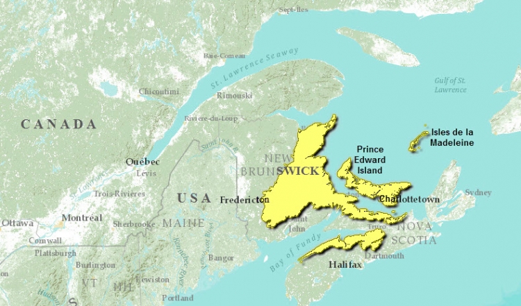
The Gulf of St. Lawrence ecoregion includes all of Prince Edward Island, Isles de la Madeleine, Quebec, most of east-central New Brunswick, the Annapolis Valley and the Northumberland Strait coast of Nova Scotia.
The mean annual temperature ranges from 4.5° to 6.5°Celsius, and mean summer temperature ranges from 12°C to 15.5°C, with the lowest temperature in Isles de la Madeleine, Quebec. Mean winter temperature is colder in the Maritime Lowlands than in the islands or the sheltered Annapolis-Minas lowlands. This ecoregion is marked by warm summers and mild, snowy winters and can be characterised primarily as an Atlantic high cool temperate ecoclimate).
 Prince Edward Island, Iles-de-la-Madeleine, and the maritime lowlands of New Brunswick and Nova Scotia are underlain by Carboniferous sandstones, shales, and conglomerates and rise inland from sea level to 200 meters (m) above sea level in elevation. Small bedrock outcrops stand as prominent hills. The Eastern portion of this region is underlain by Mesozoic sandstone in the Annapolis Valley and Palaeozoic shale, sandstone, gypsum, and limestone in the Minas Lowlands.
The Gulf of St. Lawrence strongly influences climate and vegetation dynamics over much of the ecoregion. Lowland physiography and warmer summers allow for better growth of hardwoods than in much of the New England-Acadian forests ecoregion.
Biological Distinctiveness
The closed mixedwood forests of this ecoregion are strongly influenced by a maritime climate where warm summers allow for good growth of hardwoods, which are often mixed with red spruce (Picea rubens) and balsam fir (Abies balsamea). Eastern hemlock (Tsuga canadensis) and eastern white pine (Pinus strobus) are found in the Maritime Lowlands of New Brunswick and the Annapolis-Minas Lowlands of Nova Scotia. Sugar maple (Acer saccharum), yellow birch (Betula allegheniensis) and beech (Fagus grandifolia) are more common on well-drained, higher elevation areas. Bogs and fens are significant in the Minas Lowlands, while other wet sites support white elm (Ulmus americana), black ash (Fraxinus nigra), and red maple (A. rubrum). The original mixedwood forest of PEI was characterized by red oak (Quercus rubra), sugar maple, yellow birch and beech while abandoned fields are returning to forests of white spruce (P. glauca). Although warm summers also characterize the climate of Iles-de-la-Madeleine, poor drainage results in a conifer-dominated forest of black spruce (P. mariana) and balsam fir.
Characteristic mammals across the mainland portions of the ecoregion include black bear (Ursus americanus), moose (Alces alces), white-tailed deer (Odocoileus virginianus), red fox (Vulpes vulpes), snowshoe hare (Lepus americanus), porcupine (Erithyzon dorsatum), fisher (Martes pennanti), beaver (Castor canadensis), bobcat (Lynx rufus), marten (Martes americana), raccoon (Procyon lotor), and muskrat (Ondatra zibethica). On PEI, however, black bear, fisher, bobcat and marten have been extirpated, and only red fox, snowshoe hare, beaver, and muskrat are native. Coyotes (Canis latrans) have now invaded most of the ecoregion, including PEI. A diversity of shorebirds and seabirds inhabit the salt marshes and tidal flats along the coast. This includes some of the highest breeding densities for the endangered piping plover (Charadrius melodus) in eastern North America.
Fires play a role in forest dynamics of the ecoregion, although probably on a relatively small scale (up to tens of square kilometers). At present, they are actively suppressed. High winds, sea salt spray and fog are additional strong influences on forest dynamics and vegetation communities, particularly in [[coast]al areas].
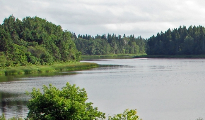
Prince Edward Island. Source: dugspr/Flickr
Exhumed skeletal forests exist in sandy areas of Prince Edward Island. The dune system at Greenwich, Prince Edward Island, has a unique structure for northeastern North America. Unique forest communities composed of mixed hardwood and softwood species also occur. Several endemic species are found here, including the Laurentian aster (Aster laurentiana), maritime ringlet butterfly (Coenonympha nepisiquit) which is found in salt marshes, and the Bathurst salt marsh aster (Aster subulatus var. obtusifolius).
A continentally significant and large population of breeding great blue herons (Ardea herodias) in North America is found on Prince Edward Island. In addition, perhaps the largest colony (12,000 pairs) of double-crested cormorants (Phalacrocorax auritus), and a major breeding population of piping plover in northeastern North America, are all found in this ecoregion.
Habitat Loss
It is estimated that only about 3 percent of this ecoregion can be considered as intact habitat. More than 75 percent is considered to be heavily altered.
Presently, the principal reasons for habitat loss are:
- Conversion of land for agriculture (especially potatoes).
- Forest harvesting and high density road networks.
- Urban and rural housing.
- Recreational disturbance of dune vegetation in [[coast]al areas].
- Extensive peat harvesting (especially in eastern New Brunswick).
Historically, agriculture and logging for shipbuilding destroyed much of the original forest cover of the ecoregion by the 19th century.
Remaining Blocks of Intact Habitat
- Area encompassing Kouchibouguac National Park, New Brunswick
Degree of Fragmentation
Habitat fragmentation is high in Prince Edward Island and Nova Scotia.
Degree of Protection
- Kouchibouguac National Park - eastern New Brunswick - 239 square kilometers (km2)
- Prince Edward Island National Park - northern Prince Edward Island - 25.9 km2
- Dollar Lake Provincial Park - northern Nova Scotia - 11.93 km2
- Ile Brion Ecological Reserve - eastern Quebec - 6.5 km2
- Brudenell River Provincial Park - eastern Prince Edward Island - 5.85 km2
Types and Severity of Threats
Threats to biodiversity protection in this ecoregion are very high. Continued logging (especially in New Brunswick , where the annual allowable cut is predicted to increase in the near future) and agriculture are the primary sources of habitat degradation and loss. Peat mining is a threat to bogs, and increased shoreline development threatens many [[coast]al regions].
Suite of Priority Activities to Enhance Biodiversity Conservation
- Widespread planning for setting restoration priorities
- Build and maintain incentives for private land protection
- Increase protection for remaining woodlands
- Increase protection for offshore islands
- The government of New Brunswick needs to come forward with a protected areas system plan that includes representative candidate sites.
- More attention required to conserve old-growth forests and [[coast]al] habitat.
Conservation Partners
- Annapolis Field Naturalists Society
- Blomidon Naturalists Society
- Canadian Parks and Wilderness Society, Nova Scotia Chapter
- Conservation Council of New Brunswick
- Environmental Coalition of Prince Edward Island
- Federation of Nova Scotia Naturalists
- Island Nature Trust
- Le Club de Naturalistes de la Peninsule Acadienne
- Moncton Naturalists’ Club
- Natural History Society of Prince Edward Island
- Nature Conservancy of Canada, Atlantic Canada
- Nature Trust of New Brunswick
- New Brunswick Federation of Naturalists
- New Brunswick Protected Natural Areas Coalition
- Nova Scotia Nature Trust
- Parks and People PEI
- Prince Edward Island Salmon Association
- Prince Edward Island Wildlife Federation
- World Wildlife Fund Canada
Relationship to Other Classification Schemes
The Gulf of St. Lawrence lowland forests overlay the Maritime Lowlands, the Annapolis-Minas Lowlands, Prince Edward Island, and the Iles-de-la-Madeleine (TEC 122, 126, 130, and 131). These ecoregions are all part of the Atlantic Maritime Ecozone, in the Acadian forest region. Forest sections include the Eastern Lowlands, Prince Edward Island, and the Central Lowlands (3, 8, 12) (Rowe 1972).
Additional Information on this Ecoregion
- For a shorter summary of this entry, see the WWF WildWorld profile of this ecoregion.
- To see the species that live in this ecoregion, including images and threat levels, see the WWF Wildfinder description of this ecoregion.
- World Wildlife Fund Homepage
| Disclaimer: This article contains information that was originally published by the World Wildlife Fund. Topic editors and authors for the Encyclopedia of Earth have edited its content and added new information. The use of information from the World Wildlife Fund should not be construed as support for or endorsement by that organization for any new information added by EoE personnel, or for any editing of the original content. |

