Southern Hudson Bay taiga

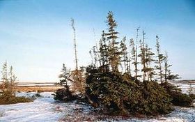
Dogsledding through the snowy Black spruce forest. Source: C.Michael Hogan
|
|
The Southern Hudson Bay taiga ecoregion within Canada extends along the lowlands adjacent to Hudson Bay from Manitoba, though Ontario and into a small part of western Quebec next to James Bay. The islands in James Bay (under the jurisdiction of the Northwest Territories) also fall within this ecoregion. Approximately 80 percent of the ecoregion lies within Ontario.

Mean annual temperatures range from -5°C to -2°C, mean summer temperatures from 10.5°C to 11.5°C, and mean winter temperatures from -19°C to -16°C. Mean annual precipitation ranges from 400 millimeters (mm) in the far north to 700 or 800 mm in the far east. Generally, the lowlands receive a mean precipitation of 500 to 700 mm annually. This ecoregion has a high subarctic ecoclimate in the north, a low subarctic ecoclimate in the lowland, and a high boreal ecoclimate in the James Bay lowland, all characterized by short, cool summers and cold winters.
Contents
Ecoregion landscape
This ecoregion is part of the Hudson Bay Lowland, within the Hudson geologic platform, and is underlain by flat-lying Palaeozoic limestone bedrock. Continued uplifting of the land surface due to isostatic rebound creates belts of raised beaches. Along the Hudson Bay coast east of the Nelson River, these well-drained beaches support white spruce, alternating with fens, polygonal peat plateaus, and peat plateaus. North of the Nelson River, beaches are more subdued and the terrain is dominated by fens, polygonal peat plateaus, and peat plateaus. The latter often occur in parallel rows marking the underlying beaches.
The coastal areas are dominated by marshes, shallow water, and tidal flats, which are extensive at the junction of the Hudson and James bays. The Hudson Bay Lowland slopes gently to the northeast and east to Hudson Bay, and its maximum elevation is around 120 metres (m) above sea level (asl) in the south. The James Bay Lowland slopes north, toward the bay. The Churchill River flows and discharges to Hudson Bay at the northern edge of this ecoregion.
Biological distinctiveness
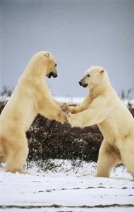 Polar bear (Ursus maritimus) Churchill, Canada.
Source: François Pierrel
Stunted black spruce and tamarack dominate the vegetation here. These trees become larger and more dense toward the south. The shrub layer consists of dwarf birch (Betula spp.), willow (Salix spp.), and northern Labrador tea (Rhododendron tomentosum, syn Ledum palustre ssp. decumbens). Poorly drained areas support dense sedge (Carex spp.), moss, and lichen covers, and the raised beaches present a striking Pattern of successive black spruce-covered (Picea mariana) ridges alternating with depressional bogs and fens. The area to the south of James Bay acts as a transition between the coniferous mixed forests to the south and the tundra to the north, and as such, has a greater diversity of species, including balsam fir (Abies balsamea), white spruce (Picea glauca), and black spruce, quaking aspen (Populus tremuloides), and paper birch (Betula papyrifera). Wetlands make up 50-75 percent of this ecoregion.
Characteristic wildlife species include caribou (Rangifer tarandus), snow goose (Chen caerulenscens), Canada goose (Branta canadensis) and snowshoe hare (Lepus americanus) throughout most of the ecoregion. Polar bear (Ursus maritimus), arctic fox (Alopex lagopus), tundra swan (Cygnus columbianus), sea ducks, shorebirds, Beluga whale (Delphinapterus leucas), and seal (Phocidae) are found along the Hudson Bay coast. Willow ptarmigan (Lagopus lagopus) occur south of the Hudson Bay coast, and toward the lower end of James Bay black bear (Ursus americanus), wolf (Canis lupus), moose (Alces alces), lynx (Lynx canadensis), ruffed grouse (Bonasa umbellus) and American black duck (Anas rubripes) are found.
 Churchill, SW Hudson Bay, Manitoba, Canada. Source: WWF/Canon, François Pierre
 This ecoregion contains some of the most extensive wetland complexes in the boreal system in North America. Isostatic rebound continues to occur at high rates in this ecoregion, possibly among the highest in the world. This has created a rapidly emerging shoreline of up to a one meter vertical increase per century. Given the flat topography, this rebound can create expanses of one or two kilometers (km) of newly exposed beach. As a result of this dynamic process and flat landscape, some of the continent’s most extensive and productive northern salt marshes in the world occur along the coastline. They support huge breeding colonies of waterfowl (particularly snow geese) and are used by these and additional waterfowl and shorebird species as major staging areas in migration. This ecoregion supports the world’s southernmost populations of polar bear.
Conservation status
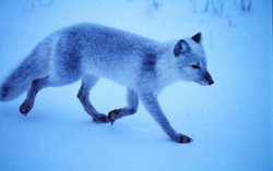 Arctic fox (Alopex lagopus), near the southwestern shore of Hudson Bay, Canada Source: WWF/ François Pierrel
 Habitat loss and degradation
It is estimated that 99 percent of this ecoregion remains as intact habitat. Small patches of disturbance occur around scattered communities.
Remaining blocks of intact habitat
Most of the ecoregion remains as an intact habitat block.
Degree of fragmentation
There is no human-induced fragmentation of any significance. Areas around Churchill, Manitoba are possibly the most impacted by the presence of a spaceport and railway line servicing a growing tourism trade and active summer seaport.
Protected areas
The following areas have some degree of protection:
- Polar Bear Provincial Park - northern Ontario - 22,880.66 square kilometers (km2)
- Wapusk National Park - northeastern Manitoba - 11,475 km2
- Jog Lake Conservation Reserve - northern Ontario - 480 km2
Types and severity of threats
Most of this ecoregion is too far north for any commercial forest harvest. Hydro-electric developments are possible future threats in the James Bay lowlands of Quebec and Ontario. Fly-in hunt camps need to be carefully monitored to ensure that harvests are maintained at sustainable levels.
Suite of priority activities to enhance biodiversity conservation
- Establish a protected area on the Ministikawatin Peninsula in Quebec.
- Expand Polar Bear Provincial Park to better include polar bear denning [[habitat]s].
- Raise the protection standards of the Cape Tatnam Provincial Wildlife Management Area, Manitoba and the Akimiski Island Migratory Bird Sanctuary in the Northwest Territories.
- Raise the protection standards of the Churchill Wildlife Management Area surrounding Wapusk National Park.
Conservation partners
- Endangered Spaces Campaign, Manitoba
- Federation of Ontario Naturalists
- Grand Conseil des Cris
- Manitoba Naturalists Society
- The Nature Conservancy, Manitoba
- The Nature Conservancy, Quebec
- Northwatch
- The Wildlands League
- World Wildlife Fund Canada, Quebec Region
Relationship to other classification schemes
The Southern Hudson Bay Taiga stretches along the southern shore of Hudson Bay and James Bay in Manitoba, Ontario, and Québec, and is characterized by the Coastal Hudson Bay Lowland, the Hudson Bay Lowland and the James Bay Lowland. Within this region, Boreal forest sections include: Hudson Bay Lowlands, East James Bay, Northern Coniferous, and Forest-Tundra.
References
- For a shorter summary of this entry, see the WWF WildWorld profile of this ecoregion.
- Arthur C.Benke and Colbert E.Cushing. 2005. Rivers of North America. 1144 pages
- Taylor H. Ricketts. 1999. Terrestrial ecoregions of North America: a conservation assessment. 485 pages
- C.Michael Hogan. 2008. Polar Bear: Ursus maritimus. Globaltwitcher.com, ed. Nicklas Stromberg
- Lauchlan H.Fraser and Paul A.Keddy. 2005. The world's largest wetlands: ecology and conservation. Cambridge University Press. 488 pages
| Disclaimer: This article contains information that was originally published by the World Wildlife Fund. Topic editors and authors for the Encyclopedia of Earth have edited its content and added new information. The use of information from the World Wildlife Fund should not be construed as support for or endorsement by that organization for any new information added by EoE personnel, or for any editing of the original content. |