Eastern forest-boreal transition
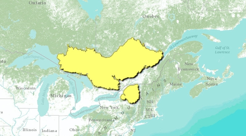
The Eastern forest-boreal transition ecoregion includes most of the southern Canadian Shield in Ontario and Quebec. The shield, in fact, principally defines the southern boundaries of this ecoregion. It lies north and west of the St. Lawrence Lowlands except for a disjunct section comprised of the Adirondack Mountains in upper New York State.
Having a humid mid-boreal ecoclimate in the northwest and a humid high cool temperate ecoclimate in the Algonquin area, the mean annual temperature ranges from 1.5°C to 3.5°C, increasing toward the south. The mean summer temperature of this region is 15°C, and the mean winter temperature ranges from -8.5°C to -11°C. Temperatures are slightly cooler in the southern Laurentians. Mean annual precipitation ranges from 800-1,000 [[meter}millimeters|]] (m); however, along the shores of Lake Superior and Georgian Bay, and between Quebec City and the Saguenay River, annual precipitation is in excess of 1,000 mm. In general, this ecoregion experiences warm summers and cold, snowy winters.
The Ontario part of this ecoregion is underlain by massive, crystalline, acidic, Archean bedrock forming undulating, broadly sloping uplands and lowlands with outcroppings. The Cobalt Plain in the northeast section of the Ontario portion is composed of flat-lying clastic sediments with ridges and hills formed by gabbro sills or granitic rock inliers. The Southern Laurentians in Quebec are composed mainly of Precambrian granites and gneisses, and are incised by a number of southward-draining rivers through highlands.
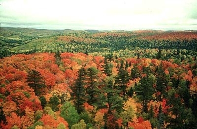
The characteristic mixed forests of this ecoregion are distinct from the predominantly deciduous forests to the south and the cooler boreal forests to the north. In the northern reaches and in the Lac Temiscamingue area, the forests transition into a more predominantly boreal forest characteristic of ecoregions to the north, although on warmer, better drained sites, deciduous species dominate.
Contents
Biological Distinctiveness
Mixed wood forests characterize this region and include white spruce (Picea glauca), balsam fir (Abies balsamea), quaking aspen (Populus tremuloides), paper birch (Betula papyrifera), and yellow birch (B. allegheniensis). Red (Pinus resinosa), white (P. strobus) and jack pine (P. banksiana) occur on drier sites in the northwest. To the south, in the Algonquin area, the mixedwood forest is characterized by stands of sugar maple (Acer saccharum), yellow birch, eastern hemlock (Tsuga canadensis) and eastern white pine, with beech (Fagus grandifolia) appearing on warmer sites. Poorly drained areas support tamarack (Larix laricina) and eastern white cedar (Thuja occidentalis), with black spruce (Picea mariana) in the north, and red maple (Acer rubrum) and black ash (Fraxinus nigra) in the Algonquin area. Wetlands occur throughout the ecoregion, usually in association with river systems and along parts of the Georgian Bay shoreline.
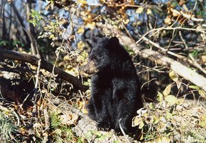
Moose (Alces alces), lynx (Lynx canadensis), black bear (Ursus americanus), snowshoe hare (Lepus americanus), wolf (Canis lupus), coyote (Canis latrans), white-tailed deer (Odocoileus virginianus), American black duck (Anas rubripes), wood duck (Aix sponsa), hooded merganser (Lophodytes cucullatus), and pileated woodpecker (Dryocopus pileatus) exist throughout, with chipmunk (Tamias striatus), mourning dove (Zenaida macroura), cardinal (Cardinalis cardinalis), and wood thrush (Hylocichla mustelina) in the Lake Nipissing-Algonquin area. The Southern Laurentians provide habitat for fewer animal species.
Forest species assemblages are highly influenced by drainage characteristics and topography. Fire is an important disturbance regime in the ecoregion on spatial scales of up to 1,000 square-kilometers (km2), particularly in the northern parts of the ecoregion. Elsewhere, smaller fires are more common.
This is the southern limit of timber wolves in eastern North America and there are emerging plans to reintroduce wolves into such areas as the Adirondacks. Recently, eastern cougar (Felis concolor) sightings have been increasing in this ecoregion. The most widespread old-growth red and white pine stands remaining in the world and one of the largest remaining areas of old-growth forest in the northeastern United States, Five Ponds Wilderness, is found here. A large percentage of the Great Lakes watershed headwaters remain as relatively intact (rare on a continental scale).
Conservation Status
Habitat Loss
It is estimated that only 10 percent of the ecoregion remains as intact habitat. Much of the area has been highly fragmented by forestry activities, settlements, summer homes and cottages, ski facilities, and agriculture.
Remaining Blocks of Intact Habitat
- Adirondack Park (although it is roaded and contains urban inclusions, such as Saranac Lake and Lake Placid) - northeastern New York
- Parc du Mont Tremblant - southwestern Quebec
- Parc Jacques Cartier - southern Quebec
- La Maurice National Park - southwestern Quebec
- Algoma Highlands
- Algonquin Provincial Park (highly roaded) - southern Ontario
- Bark Lake
- Missasaugi Uplands
- Quirke-Whiskey Lakes
- South Ranger Lake
Degree of Fragmentation
The ecoregion is highly fragmented by public roads, logging roads, large scale logging, and settlement patterns.
Degree of Protection
- Adirondack State Park
- Algonquin Provincial Park - Protected portion (1,583.37 km2). Logging permitted in an additional 6,069 km2 of the park. Total park area: 7,652.45 km2
- Lake Superior Provincial Park - southern Ontario - 15.56 km2 (much of it previously logged)
- Parc du Mont Tremblant (provincial park) - 1,490 km2
- Lady Evelyn - Smoothwater Provincial Wilderness Park - central Ontario - 724 km2
- Parc Jacques Cartier (provincial park) - 670.6 km2
- La Maurice National Park - 543.9 km2
- French River Waterway Provincial Park - central Ontario - 511.2 km2
- Killarney Provincial Park - southern Ontario - 485 km2
- Gatineau Park, National Capital Commission - southwestern Quebec - 344 km2
- Parc des Grands Jardin (provincial park) - southern Quebec - 310 km2
- Mississagi Provincial Waterway Park - central Ontario - 198.14 km2
- Obabika River Provincial Waterway Park - central Ontario - 170 km2
- Blackstone Harbour Provincial Natural Environment Park - southern Ontario - 119.76 km2
- Wakami Lake Provincial Park - central Ontario - 88.06 km2
- Chapleau - Nemegosenda Provincial Waterway Park - central Ontario - 81.65 km2
- La Cloche Provincial Park - central Ontario - 74.48 km2
- Bon Echo Provincial Park - southeastern Ontario - 66.44 km2
Types and Severity of Threats
The timber industry continues to be very active in the ecoregion, particularly in the Canadian portion. There is increased mining potential throughout and tourism is beginning to create significant impacts in parts of the ecoregion.
Suite of Priority Activities to Enhance Biodiversity Conservation
- Continue acquisition of private lands within Adirondack State Park
- Protect Hautes Gorges in Quebec
- Upgrade protection standards for La Verendrye, Rolland Germain, Papineau Labelle, and Laurentides Wildlife Reserves in Quebec and Algonquin Provincial Park in Ontario
- Establish a major protected area in the Algoma Highlands of Ontario
- Protect additional old-growth forest stands in the Temagami area in Ontario
- Protect the Mississagi Uplands, Bark Lake, South Ranger Lake, and Rawhide Lake old growth forest sites in Ontario
- Upgrade protection standards for Chapleau, Nipissing, and Peterborough Crown Game Preserves in Ontario
- Develop a protection plan for the Little Claybelt, shared by Ontario and Quebec
Conservation Partners
- Adirondack Council
- Ancient Forest Exploration and Research
- Association Touristique Régionale de Charlevoix (ATR)
- Canadian Parks and Wilderness Society, Quebec
- Earthroots
- Federation of Ontario Naturalists
- Muskoka Field Naturalists
- The Nature Conservancy
- The Nature Conservancy
- The Nature Conservancy - Eastern Regional Office
- The Nature Conservancy of Canada
- Nipissing Naturalists Club
- Northwatch
- Orillia Naturalists’ Club
- Regroupement National des Conseils Régionauxde l'Environnement du Québec (RNCREQ)
- Residents Committee to Protect the Adirondacks
- REVE (Regroupement écologiste Val d'Or et environs)
- UQCN - Union Québecoise pour la onservation de la Nature
- Wild Earth, Vermont
- The Wildlands League (Canada)
- World Wildlife Fund Canada, Quebec Region
Relationship to Other Classification Schemes
This mixed wood forest region is composed of the Lake Temiskaming lowland, the southern Laurentians, and the Algonquin-Lake Nipissing area (TEC ecoregions 97, 98, and 99). Because this ecoregion is a transition zone, it is characterized by a variety of forest types, including the Laurentide-Onatchiway (1a), Chibougamau-Natashquan (1b), Gouin (3) and Missinaibi-Cabonga (7) within the Boreal forest region. In the Great Lakes-St. Lawrence forest region, sections include the Laurentian, Algonquin-Pontiac, Middle Ottawa, Georgian Bay, Sudbury-North Bay, Saguenay, Haileybury Clay, Temagami, and Algoma (4a, 4b, 4c, 4d, 4e, 7-10).
| Disclaimer: This article is taken wholly from, or contains information that was originally published by, the World Wildlife Fund. Topic editors and authors for the Encyclopedia of Earth may have edited its content or added new information. The use of information from the World Wildlife Fund should not be construed as support for or endorsement by that organization for any new information added by EoE personnel, or for any editing of the original content. |


