River
Contents
Introduction to Rivers (Source: Biodiversity Institute of Ontario (River) )
Rivers are of immense importance geologically, biologically, historically and culturally. Although they contain only about 0.0001% of the total amount of water in the world at any given time, rivers are vital carriers of water and nutrients to areas all around the earth. They are critical components of the hydrological cycle, acting as drainage channels for surface water – the world's rivers drain nearly 75% of the earth's land surface. They provide habitat, nourishment and means of transport to countless organisms; their powerful forces create majestic scenery; they provide travel routes for exploration, commerce and recreation; they leave valuable deposits of sediments, such as sand and gravel; they form vast floodplains where many of our cities are built; and their power provides much of the electrical energy we use in our everyday lives. Rivers are central to many of the environmental issues that concern society, and they are studied by a wide range of specialists including hydrologists, engineers, ecologists and geomorphologists.
Natural Watercourses
 (Source: Biodiversity Institute of Ontario)
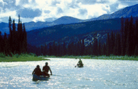
 Rivers are natural watercourses, flowing over the surface in extended hollow formations (i.e., channels), which drain discrete areas of mainland with a natural gradient. In basic terms the existence of a river depends on three things: the availability of surface water, a channel in the ground, and an inclined surface. In this sense the term "river" includes all kinds of watercourses, from the tiniest of brooks to the largest of rivers (the term "stream" is used interchangeably with river when describing characteristics of the watercourse). Essentially, a river represents the excess of precipitation over evaporation for a certain land area (see the general section on the hydrological cycle).
Lotic Systems
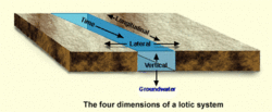 The four dimensions of a lotic system. (Source: Biodiversity Institute of Ontario)
 Rivers and [[stream]s] are characterized by flowing waters and are called lotic systems (as opposed to lentic systems, such as lakes). Lotic environments have been described as having four dimensions: a longitudinal dimension with a pronounced zonation of chemical, physical and biological factors (comparable to the vertical stratification in lakes); a lateral dimension involving exchanges of organic matter, nutrients and biota between the stream channel and the adjacent floodplain; a vertical dimension consisting of a hydraulic connection linking the river channel with groundwater; and a fourth dimension of time which pertains to the velocity of the water flow.
Variation in Time and Space
 (Source: Biodiversity Institute of Ontario)
 Rivers are very dynamic and show tremendous variation through time and space. The shape, size and content of a river are constantly changing, forming a close and mutual interdependence between the river and the land it traverses. Imagine following one river from a small trickle in the mountains, over raging rapids and waterfalls, through areas of peaceful, nearly motionless water, all the way to its meshing with the mighty waves of the sea.
On its way, a river may carve through majestic mountain ranges, create deep gorges and canyons, gentle valleys, lush meadows, and mighty plains, all the while providing the setting for a diversity of biological communities. Over time it may change drastically from a roaring, overflowing force in the spring, to a still, icy-cold mass in the winter.
The River Continuum
 (Source: Biodiversity Institute of Ontario)
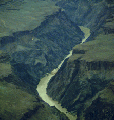
 A river begins at a source and flows following elevation gradients (i.e., by the force of gravity) down to its endpoint, called the mouth (which may be another river, a lake, or an ocean). The source is the highest point in the watercourse and may be a spring, a lake or marshy area, or glacial meltwaters in high mountain regions. The river follows a concave longitudinal profile from the steeper headwater regions, where erosional effects predominate, to the gently sloping lower courses where more material is deposited as sea level is approached. It tends to become larger, deeper, wider and smoother as it progresses downstream. The river continuum is a concept based on the characteristic changes in a river as it progresses from the source to the mouth. It identifies a downstream gradient of physical and chemical factors moving from the headwaters to the lowland rivers, correlating this gradient with changes in the biological communities. The gradient is apparent in things such as channel shape, sediment load, nutrient status, temperature and water velocity, with each factor playing a role in determining the diversity and productivity of the stream organisms. The river continuum is thus a very important concept in the overall study of lotic systems, and one that is pertinent to many of the later sections.
River Zonation
 (Source: Biodiversity Institute of Ontario)
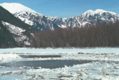
 Many attempts have been made to classify rivers into discrete zones based on their characteristics. Several criteria have been used, including various combinations of the following: width, depth, current velocity, temperature, chemical composition of the surrounding rocks and soil, streamside vegetation, flora, fauna, water temperature, dissolved organic and inorganic matter, dissolved oxygen, water hardness. The list is extensive and the resulting classification is heavily influenced by the context in which it is used. For example, many early classification systems were devised by fisheries (Fisheries and aquaculture) biologists and were hence based on the dominant species of fish present. Some researchers believe that the wide variety of both abiotic and biotic factors involved in rivers defies classification. Nevertheless, one system of river zonation has gained relatively widespread acceptance. It divides rivers into three primary zones:
 (Source: Biodiversity Institute of Ontario)
 (a) The crenon is the uppermost zone at the source of the river. It is further divided into the eucrenon (spring or boil zone) and the hypocrenon (brook or headstream zone). These areas are characterized by low temperatures, reduced oxygen content and slow moving water.
(b) The rhithron is the upstream portion of the river that follows the crenon. It is characterized by relatively cool temperatures, high oxygen levels, and fast, turbulent flow.
(c) The potamon is the remaining downstream stretch of river. It is characterized by warmer temperatures, lower oxygen levels, slow flow and sandier bottoms.
Effects of Climate
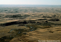 Grasslands National Park. (Source: Photo by Parks Canada-Grasslands National Park)
 Rivers are very dependent on climate and their characteristics are closely related to the precipitation and evaporation regimes in their drainage areas. Three main types of rivers have been distinguished:
(a) Perennial or permanent rivers have a constant flow of water (although there may be considerable seasonal variation in amount of flow) and occur in regions where precipitation generally exceeds evaporation (such as Canada).
(b) Periodic rivers may run dry occasionally but have streamflow during regular periods of variable duration. These occur in regions where evaporation exceeds precipitation on an annual average but periodically precipitation is greater.
(c) Episodic rivers only rarely and fleetingly have water in their channels. These occur in very arid climates (such as desert regions).
