Mountain
| Topics: |
Geology (main)
|
Introduction
A mountain can be defined as an area of land that rises abruptly from the surrounding region. A mountain range is a succession of many closely spaced mountains covering a particular region of the Earth. Mountain belts consist of several mountain ranges that run roughly parallel to each other. The North American Cordillera, the Himalayas, the Alps, and the Appalachians are all examples of mountain belts that are composed of numerous mountain ranges. Figure 1: This image shows the topography of both land and ocean surfaces. Elevation is indicated by color. The legend below shows the relationship between color and elevation. The Earth's major mountain systems are generally colored orange to red to grey. Some of the major mountain belts on the Earth are the North American Cordillera (A), Appalachians (B), Caledonian Belt (C), Andes (D), Urals (E), Himalaya (F), Alps (G), and the Tasman Belt (H). (Source of Modified Image: NOAA, National Geophysical Data Center) Some mountains are volcanic in origin forming where rising magma breaks through the Earth's surface. Volcanic mountains tend to have sporadic distributions within a mountain range (Mounts St. Helens, Rainier, and Baker) or can occur alone because of a localized hot spot (Hawaiian Islands). Most mountains were created from tectonic (Mountain) forces that elevate, fold, and fault rock materials. Tectonic mountains can occur as a single range (the Urals) or as a belt of several mountain ranges (North American Cordillera). Figures 1 and 2 show the location of some of the major mountain systems found on the Earth's surface. These major mountain systems include the North American Cordillera (A and D), Andes, Alps (G), Urals (E), Appalachians (B), Himalayas (F), Caledonian Belt (C), and the Tasman Belt (H).
The Earth's mountain ranges have various ages of formation. Parts of the Himalayas are relatively quite young. Mountain building in this region of the world began about 45 million years ago when the continental plates of India and Eurasia converged on each other. The Himalaya mountains are still actively being uplifted. The Appalachian belt is quite old. Mountain building in this region of the world started about 450 million years ago. Orogeny stopped in the Appalachians about 250 million years ago. The long passage of time without active uplift has allowed weathering and erosion to remove large amounts of bedrock from the Appalachians. These processes have also significantly lowered and rounded the peaks of the various mountains found in this belt. Mountain building episodes in the North American Cordillera have been occurring over a very long period of time and still continue today. Some sedimentary rocks in the Rocky Mountain range (located on the eastern edge of the North American Cordillera) date to over a billion years old.
Evolution of Mountains

Geologists have developed a general model to explain how most mountain ranges form. This model suggests that mountain building involves three stages:
- accumulation of sediments;
- an orogenic period of rock deformation and crustal uplift; and,
- a period of crustal uplift caused by isostatic rebound and block-faulting.
The later two stages of this model involve tectonic convergence of crustal plates which provides the compressional and tensional stresses that produce rock deformation, uplift, and faulting.
Mountain belts normally contain numerous layers of sedimentary and volcanic igneous rocks. These accumulations can be several kilometers in thickness. Most of these accumulations were originally deposited in a marine environment. The beds of the sedimentary rocks are composed of particles that came from nearby terrestrial landmasses. These particles were released from rocks by weathering and then transported by erosional forces to the edge of the terrestrial continental crust. Beyond the edge of the continents, these sediments are lithified to form shales, limestones, and sandstones that make up the continental shelves, slopes, and rise. Accumulations of volcanic rock develop along convergent boundaries where subduction is causing magma plumes to form plutons and volcanoes. The volcanoes are usually spatially organized in a line, called an island arc, that runs at right angles to the direction of crustal movement.
In the orogenic stage of mountain building, the accumulated sediments become deformed by compressional forces from the collision of [[tectonic] plates]. This tectonic convergence can be of three types: arc-continent, ocean-continent or continent-continent. In an ocean-continent convergence, the collision of ocean and continental plates causes the accretion of marine sedimentary deposits to the edge of the continent. Arc-continent convergence occurs when an island arc collides with the edge of a continental plate. In this convergence, the ocean plate area between the arc and the continent is subducted into the asthenosphere and the volcanic rocks and sediments associated with the island arc become accreted to the margin of the continent over time. This type of collision may have been responsible for the creation of the Sierra Nevada mountains in California during the Mesozoic Era. The final type of convergence occurs when an ocean basin closes and two continental plates collide. Continent-continent convergence mountain building is responsible for the formation of the Himalayas, Ural, and Appalachian mountain systems.

In all three types of tectonic convergence, layered rocks that were once located in the ocean basin are squeezed into a smaller and smaller area. This compression causes the once flat sedimentary beds to be folded and uplifted. When the compressional forces become greater than the rocks ability to deform, faulting occurs. Compressional forces typically result in reverse and overthrust faulting. Another consequence of the orogenic stage is regional metamorphism and the incursion of magma plumes, plutons, and volcanoes into the growing mountain range.
Figure 4 illustrates how the collision Eurasian and Indian plates created the Himalayas. In this orogeny, compressional forces squished sedimentary deposits that existed between the converging continental plates and rocks at the margin of the Eurasian and Indian plates upward in elevation. These forces also created a number of overthrust faults.
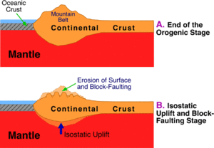
At the end of plate convergence, mountain building enters its final stage. This stage is characterized by crustal uplift because of isostatic rebound and block-faulting (Figure 5). Isostatic rebound involves the vertical movement of continental crust that is floating in the plastic upper mantle. As erosion removes surface materials from mountains, the weight of the crust in this region becomes progressively less. With less weight, the continental crust makes an isostatic adjustment causing it to rise vertically (float higher) in the mantle. This process also causes tensional forces to exist in a horizontal direction breaking the continental crust into a number of blocks. Each block moves vertically to compensate for the tensional forces producing normal and graben faults.


