Queen Charlotte Islands
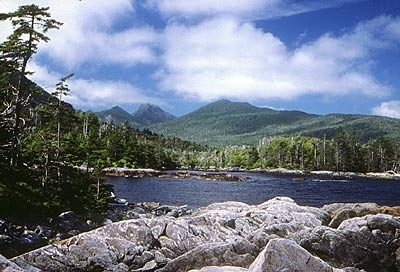
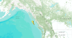
The Queen Charlotte Islands represent a major offshore archipelago of islands separated from the British Columbia and Alaskan mainland by Hectate Strait at a distance of approximately 75-100 kilometers (km).
The climate in this ecoregion is considered oceanic and maritime South Pacific Cordilleran. The mean annual temperature is 7.5°C, mean summer temperature is 11.5°C, and mean winter temperature is 3.5°C. Annual precipitation in the islands is between 800 (in eastern areas) and 4,000 millimeters (mm) (on western slopes) per year.
Physiographically, the Queen Charlotte Islands are characterized by irregular, steep slopes in the west and gently sloping lowlands in the east.
Biological Distinctiveness
This ecoregion has significant areas of old-growth, west coast rainforests. Watersheds on the islands are important for anadromous fish while elevational gradients result in high terrestrial species richness and community variation.
Along the west coast of the islands, vegetation is comprised of stunted, open-growing western red cedar (Thuja plicata), yellow cedar (Chamaecyparis nootkatensis), shore pine (Pinus contorta var. contorta), and western hemlock (Tsuga heterophylla). Better drained sites also support Sitka spruce (Picea sitchensis). Wetlands are common in the islands and are comprised of open western hemlock and shore pine.
Several species of introduced mammals are present on the island, including black-tailed deer (Odocoileus hemionus), elk (Cervus elaphus), raccoon (Procyon lotor), rats (Rattus spp.), eastern gray squirrel (Sciurus carolinensis) and beaver (Castor canadensis). Native, common wildlife includes black bear (Ursus americanus), river otter (Lontra canadensis), seabirds, shorebirds, and marine mammals.
This ecoregion is a critical stopover for migratory waterbirds flying north to Alaska and south to Mexico. As one of the most isolated island archipelagos in western North America, the ecoregion harbors several endemic subspecies of plants, birds, and small mammals as well as an endemic sub-species of black bear. Critical nesting sites for colonial nesting birds and raptors are also found here.
Conservation Status
Habitat Loss
Approximately 50% of the habitat has been altered on the Queen Charlotte Islands, primarily as a result of clearcut logging. The remaining habitat is relatively intact. High rainfall levels in this ecoregion have created serious erosion and landslide problems where logging has been extensive. The logging has provided habitat suitable for the introduced black-tailed deer, which in turn are causing other serious habitat impacts through selective over-browsing of some conifer and forest understory species.
Remaining Blocks of Intact Habitat
- Naikoon/Tlell Watershed - approx. 1,200 square-kilometers (km2)
- Gwaii Haanas - National Park Reserve and Haida Heritage Site (1,450 km2 of which 1,200 km2 is not logged)
- Duu-Guusd (northwest Graham Island) - 1,500 km2
- North-central Graham Island - approx. 800 km2
- Englefield Bay - approx. 700 km2
Degree of Fragmentation
Logging has been the principal land-use responsible for the fragmentation of habitat. Since logging is directed principally at the valley bottom and lower slope forests, fragmentation occurs for upper slope communities and impacts species movements.
Degree of Protection
- Gwaii Haanas National Park Reserve - 1,470.4 km2
- Naikoon Provincial Park - 726.41 km2
- Krajina Ecological Reserve - 98.34 km2
- Drizzle Lake Ecological Reserve - 8.37 km2
- Tow Hill Ecological Reserve - 5.14 km2
Types and Severity of Threats
Logging and road building remain significant threats to mature forest habitat and to some species such as marbled murrelets (Brachyramphus marmoratus), cavity nesters and raptors. Introduced species to this island system are also a major threat to native biodiversity. Black tailed deer are having a major impact on the regeneration of western red cedar, a dominant species in many of the islands’ forested habitats. Damming by introduced beaver of small streams used by coho salmon (Oncorhynchus kisutch) for spawning threaten some stocks. The introduction of rats (Rattus spp.), squirrels (Sciurus spp.) and raccoons have had a profound impact on seabird colonies.
Suite of Priority Activities to Enhance Biodiversity Conservation
- Protect Duu-Guusd (northwest Graham Island)
- Protect the Tlell River watershed
- Protect Government Creek Watershed System
- Reduce rate of forest harvest (especially clearcutting of rainforest)
- Formulate plans to control (or remove) [[introduced] species]
Conservation Partners
- British Columbia Wild
- Gowgaia Institute
- Laskeek Bay Conservation Society
- The Nature Conservancy, British Columbia
- Sierra Club of British Columbia
- Tlell Watershed Society
- World Wildlife Fund Canada
Relationship to Other Classification Schemes
The Queen Charlotte Islands are characterized by the Queen Charlotte Lowland and Ranges (TEC 188 and 189). The Ranges form the backbone of the Islands, and the Lowland in the north and east is primarily forested plain and wetlands. The Islands fall within the Coast forest region (4), and have a rainforest type of vegetation.
| Disclaimer: This article is taken wholly from, or contains information that was originally published by, the World Wildlife Fund. Topic editors and authors for the Encyclopedia of Earth may have edited its content or added new information. The use of information from the World Wildlife Fund should not be construed as support for or endorsement by that organization for any new information added by EoE personnel, or for any editing of the original content. |


