Mexico
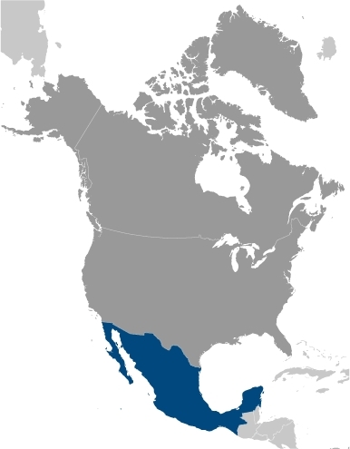
Countries and Regions of the World Collection  Mexico is a North American nation of one hundred and fifteen million people located between the United States to the north and the Central American nations of Guatemala and Belize to the south.
Mexico's main environmental issues include:
- scarcity of hazardous waste disposal facilities; rural to urban migration;
- scarce and polluted fresh water resources in the northern parts of the country:
- inaccessible and poor water quality in central regions and extreme southeast regions;
- raw sewage and industrial effluents polluting rivers in urban areas;pb
- deforestation;
- overfishing leading to coral reef damage;
- widespread erosion;
- desertification;
- deteriorating agricultural lands;
- serious air (Air pollution) and water pollution in the national capital and urban centers along US-Mexico border; and,
- land subsidence in Valley of Mexico caused by groundwater overdrafting.
The Mexican government considers both the lack of clean water and deforestation to be national security issues.
The locus of advanced Amerindian civilizations, Mexico came under Spanish rule for three centuries before achieving independence early in the 19th century.
A devaluation of the peso in late 1994 threw Mexico into economic turmoil, triggering the worst recession in over half a century. The global financial crisis beginning in 2008/09 caused another massive economic downturn the following year. As the economy attempts to recover, ongoing economic and social concerns include low real wages, underemployment for a large segment of the population, unbalanced income distribution, and few advancement opportunities for the largely Amerindian population in the impoverished southern states.
The elections held in 2000 marked the first time since the 1910 Mexican Revolution that an opposition candidate - Vicente Fox of the National Action Party (PAN) - defeated the party in government, the Institutional Revolutionary Party (PRI). He was succeeded in 2006 by another PAN candidate Felipe Calderon.
Since 2007, Mexico's powerful drug-trafficking organizations have engaged in bloody feuding, resulting in tens of thousands of drug-related homicides.
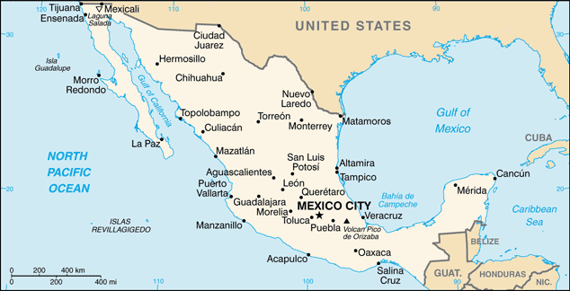 Map of Mexico. Source: CIA, The World Factbook
Contents
Geography
Location: Middle America, bordering the Caribbean Sea and the Gulf of Mexico, between Belize and the United States and bordering the North Pacific Ocean, between Guatemala and the United States of America.
Geographic Coordinates: 23 00 N, 102 00 W
Area: 1,972,550 sq km (1,923,040 sq km of land, 49,510 sq km of water)
arable land: 12.66%
permanent crops: 1.28%
other: 86.06% (2005)
Coastline: 9330 km
Maritime Claims: Territorial sea to 12 nautical miles, contiguous zone: 24 nautical miles, exclusive economic zone to 200 nautical miles, continental shelf to 200 nautical miles or to the edge of the continental margin.
Natural Hazards: Tsunamis along the Pacific coast, volcanoes and destructive earthquakes in the center and south, and hurricanes on the Pacific, Gulf of Mexico, and Caribbean coasts
Volcanism: volcanic activity in the central-southern part of the country; the volcanoes in Baja California are mostly dormant; Colima (elev. 3,850 m), which erupted in 2010, is Mexico's most active volcano and is responsible for causing periodic evacuations of nearby villagers; it has been deemed a "Decade Volcano" by the International Association of Volcanology and Chemistry of the Earth's Interior, worthy of study due to its explosive history and close proximity to human populations; Popocatepetl (elev. 5,426 m) poses a threat to Mexico City; other historically active volcanoes include Barcena, Ceboruco, El Chichon, Michoacan-Guanajuato, Pico de Orizaba, San Martin, Socorro, and Tacana
Snow-capped Colima Volcano, the most active volcano in Mexico, rises abruptly from the surrounding landscape in the state of Jalisco in the center of this false-color satellite image. Part of the trans-Mexican volcanic belt, Colima is actually a melding of two volcanoes, the older Nevado de Colima to the north and the younger, historically active Volcan de Colima to the south. Approximately 300,000 people live within 40 km (25 mi) of the volcano earning it designation as a Decade Volcano by the International Association of Volcanology and Chemistry of the Earth's Interior. Legend has it that gods sit atop the volcano on thrones of fire and ice. For other active volcanoes in Mexico, see the Natural hazards-volcanism subfield in the Geography section. Image courtesy of USGS.
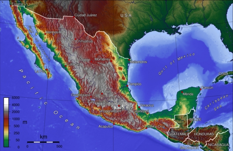
Terrain: High, rugged mountains; low coastal plains; high plateaus; desert; highest point is Volcan Pico de Orizaba (5700 m).
Climate: Varies from tropical to desert
Topography of Mexico.
Ecology and Biodiversity
Mexico is one of the most biologically diverse countries, and is home to more mammal species than any Central American country. With over 200,000 different species, Mexico is home of 10–12% of the world's biodiversity. Mexico ranks first in biodiversity in reptiles with 707 known species, second in mammals with 438 species, fourth in amphibians with 290 species, and fourth in flora, with 26,000 different species. Mexico is also considered the second country in the world in ecosystems and fourth in overall species. Approximately 2,500 species are protected by Mexican legislations. The Mexican government created the National System of Information about Biodiversity, in order to study and promote the sustainable use of ecosystems. The coral reef areas of Mexico are under threat from overfishing and from boat damage, due to lack of protection of coral areas from boat and tourist traffic.(Wilkenson & Souter, 2005)
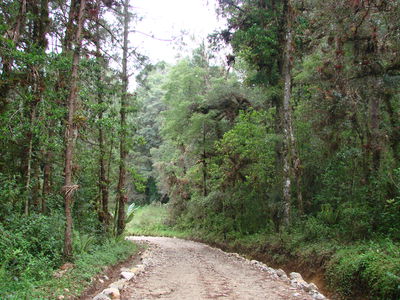 Chiapas Oak-Pine forest. Photo credit -William Cetzal-Ix. Source- Saikat Basu, own work. Chiapas Oak-Pine forest. Photo credit -William Cetzal-Ix. Source- Saikat Basu, own work.
|
 Pinus sp. Chiapas, Mexico-Afforestation. Ph ... Cetzal-Ix. Source-Saikat Basu, own work Pinus sp. Chiapas, Mexico-Afforestation. Ph ... Cetzal-Ix. Source-Saikat Basu, own work
|
The Mesoamerica Biodiversity Hotspot begins in central Mexico and extends south to the Panama Canal. A small section of the California Floristic Biodivresity Hotspot extends into the northwestern most corner of Mexico. Covering Mexico's main mountain chains is the biologically diverse area known as Madrean pine-oak woodlands. Mexico is also home to a number of terrestrial ecoregions, as defined by the World Wildlife Fund:
Source: World Wildlife Fund
|
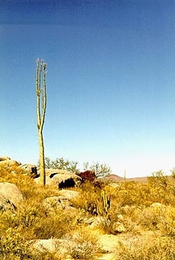
Near San Fernando, Baja California, Mexico (Source: Timothy Green) |
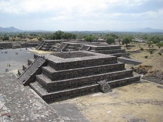
| One of the smaller step pyramids at the massive archaeological site of Teotihuacan (approximately 40km or 25mi northeast of Mexico City). |
The Commission for Environmental Cooperation has also defined more broad ecoregions within Mexico. The North American Deserts ecoregion extends into north central Mexico. In northeastern Mexico lies the Great Plains ecoregion that were once covered with natural grasslands. The Temperate Sierras ecoregion comprises the major Mexican mountain ranges. The Tropical Dry Forests ecoregion occupies the Northern Gulf Coastal Plain, the north of the Yucatán Peninsula and the southern tip of the Baja California Peninsula, covering almost 13 percent of Mexico. The Tropical Humid Forests ecoregion encompasses the Gulf Coastal Plain, the western and southern part of the Pacific Coastal Plain, most of the Yucatán Peninsula and the lowlands of the Chiapas Sierra Madre, which continue south to Central and South America.
Mexico is also home to a wide variety of coastal mangrove ecoregions as defined by the World Wildlife Fund:
- Alvarado mangroves
- Marismas Nacionales-San Blas mangroves
- Mayan Corridor mangroves
- Mexican South Pacific Coast mangroves
- Northwest Mexican Coast mangroves
- Petenes mangroves
- Ría Lagartos mangroves
- Tehuantepec-El Manchon mangroves
- Usumacinta mangroves
And is surrounded by several important marine ecosystems: the California Current large marine ecosystem to the northwest, the Pacific Central-American Coastal large marine ecosystem to the southwest, the Gulf of California large marine ecosystem between Baja California and mainland Mexico, and the Gulf of Mexico large marine ecosystem to the east.
Protected Areas
See main article: Protected areas of Mexico
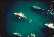 Whales from Whale Sanctuary of El Vizcaino. (Source: UNESCO)
 In Mexico, 170,000 square kilometres are considered "Protected Natural Areas." These include 34 reserve biospheres (unaltered ecosystems), 64 national parks, 4 natural monuments (protected in perpetuity for their aesthetic, scientific or historical value), 26 areas of protected flora and fauna, 4 areas for natural resource protection (conservation of soil, hydrological basins and forests) and 17 sanctuaries (zones rich in diverse species). One of the most ecologically intact ecosystems in the world, valuable both to science and for its fisheries, is the Islands and Protected Areas of the Gulf of California of Mexico. On the eastern side of the Yucatan Peninsula in the State of Quintana Roo lies the Sian Ka'an Biosphere Reserve where when possible, boundaries were defined to coincide with natural features: bounded by the Caribbean Sea and the barrier reef to a depth of 50 meters in the east; the junction between the marshes and semi-evergreen forests in the south-east; and the junction of Chetumal and Espiritu Santo Bays catchment basin in the south. The Whale Sanctuary of El Vizcaíno consists of two lagoons which lie in the central part of the Baja California peninsula, between the Gulf of California and the [[Pacific] Ocean].
This high-resolution satellite image shows part of the Sierra Madre Oriental mountain range, on the border between the Coahuila and Nuevo Leon provinces of eastern Mexico. This range is part of the Sierra Madre Mountains that divide Mexico, and which also include the Sierra Madre Occidental on the West coast and the Sierra Madre del Sur in southern Mexico. In the area shown, ancient sedimentary rocks were folded as a result of a tectonic collision that some geologists consider related to the Appalachian folding of eastern North America. This mountain range is drier than the rainforest areas to the south. Image courtesy of USGS.
People and Society
Population: 114,975,406 (July 2012 est.)
Mexico is the most populous Spanish-speaking country in the world and the second most-populous country in Latin America after Portuguese-speaking Brazil. About 76% of the people live in urban areas. Many Mexicans emigrate from rural areas that lack job opportunities--such as the underdeveloped southern states and the crowded central plateau--to the industrialized urban centers and the developing areas along the U.S.-Mexico border. According to some estimates, the population of the area around Mexico City is nearly 22 million, which would make it the largest concentration of population in the Western Hemisphere. Cities bordering on the United States--such as Tijuana and Ciudad Juarez--and cities in the interior--such as Guadalajara, Monterrey, and Puebla--have undergone sharp rises in population in recent years.
Mexico has made great strides in improving access to education and literacy rates over the past few decades. According to a 2006 World Bank report, enrollment at the primary level is nearly universal, and more children are completing primary education. The average number of years of schooling for the population 15 years old and over was around 8 years during the 2004-2005 school year, a marked improvement on a decade earlier--when it was 6.8 years--but low compared with other Organization for Economic Cooperation and Development (OECD) countries.
Ethnic groups: mestizo (Amerindian-Spanish) 60%, Amerindian or predominantly Amerindian 30%, white 9%, other 1%
Age Structure:
0-14 years: 28.2% (male 16,395,974/female 15,714,182)
15-64 years: 65.2% (male 35,842,495/female 38,309,528)
65 years and over: 6.6% (male 3,348,495/female 4,113,552) (2011 est.)
Population Growth Rate: 1.086% (2012 est.)
Birthrate: 18.87 births/1,000 population (2012 est.)
Death Rate: 4.9 deaths/1,000 population (July 2012 est.)
Net Migration Rate: -3.11 migrant(s)/1,000 population (2012 est.)
Life Expectancy at Birth: 76.66 years
male: 73.84 years
female: 79.63 years (2012 est.)
Total Fertility Rate: 2.27 children born/woman (2012 est.)
Languages: Spanish only 92.7%, Spanish and indigenous languages 5.7%, indigenous only 0.8%, unspecified 0.8%; note - indigenous languages include various Mayan, Nahuatl, and other regional languages (2005)
Literacy: 91% (2005 est.)
Urbanization: 78% of total population (2010) growing at a 1.2% annual rate of change (2010-15 est.)
History
Highly developed cultures, including those of the Olmecs, Mayas, Toltecs, and Aztecs, existed long before the Spanish conquest. Hernan Cortes conquered Mexico during the period 1519-21 and founded a Spanish colony that lasted nearly 300 years.
Independence from Spain was proclaimed by Father Miguel Hidalgo on September 16, 1810. Father Hidalgo's declaration of national independence, “Viva Mexico!,” known in Mexico as the "Grito de Dolores," launched a decade-long struggle for independence from Spain. Prominent figures in Mexico's war for independence were: Father Jose Maria Morelos; Gen. Augustin de Iturbide, who defeated the Spaniards and ruled as Mexican emperor from 1822-23; and Gen. Antonio Lopez de Santa Ana, who went on to dominate Mexican politics from 1833 to 1855. An 1821 treaty recognized Mexican independence from Spain and called for a constitutional monarchy. The planned monarchy failed; a republic was proclaimed in December 1822 and established in 1824.
Throughout the rest of the 19th century, Mexico's government and economy were shaped by contentious debates among liberals and conservatives, republicans and monarchists, federalists and those who favored centralized government. During the four presidential terms of Benito Juarez (1858-72), Mexico experimented with modern democratic and economic reforms. President Juarez' terms in office and Mexico's early experience with democracy were interrupted by the invasion of French forces in early 1862. They imposed a monarchy on the country in the form of Hapsburg archduke Ferdinand Maximilian of Austria, who ruled as emperor from 1864-67. Liberal forces succeeded in overthrowing, and executing, the emperor in 1867 after which Juarez returned to office until his death in 1872. Following several weak governments, the authoritarian General Porfirio Diaz assumed office and was president during most of the period between 1877 and 1911.
Mexico's severe social and economic problems erupted in a revolution that lasted from 1910 until 1920 and gave rise to the 1917 constitution. Prominent leaders in this period--some of whom were rivals for power--were Francisco Madero, Venustiano Carranza, Pancho Villa, Alvaro Obregon, Victoriano Huerta, and Emiliano Zapata. The Institutional Revolutionary Party (PRI), formed in 1929 under a different name, emerged from the chaos of revolution as a vehicle for keeping political competition among a coalition of interests in peaceful channels. For 71 years, Mexico's national government was controlled by the PRI, which won every presidential race and most gubernatorial races until the July 2000 presidential election of Vicente Fox Quesada of the National Action Party (PAN), in what were widely considered at the time the freest and fairest elections in Mexico's history. President Fox completed his term on December 1, 2006, when Felipe Calderon, also of the PAN, assumed the presidency.
President Calderon has made combating organized crime a priority of his administration and, to that end, has deployed the Mexican military to 10 Mexican states to assist (or replace) the weak and often corrupt local and state police. Transnational criminal organizations (TCOs) have responded to increased pressure on their activities with unprecedented violence directed mostly at competing cartels, but also government security forces and innocent citizens. They have also expanded their business beyond narcotics into kidnapping, migrant smuggling, and extortion. New estimates suggest that of over the roughly 40,000 deaths attributed to narco-violence since December 2006, nearly 2,000 were members of the Mexican security services. The Mexican military and police have been increasingly successful in carrying out operations to remove top cartel leaders, including Jose de Jesus “El Chango” Mendez (La Familia cartel--arrested in June 2011); Antonio Ezequiel Cardenas Guillen “Tony Tormenta” (Gulf Cartel--killed in a shootout in November 2010); Edgar Valdez Villareal “La Barbie” (Beltran Leyva Cartel--arrested in August 2010); Ignacio Coronel Villareal “Nacho” (Sinaloa Cartel--killed in shootout in July 2010); Eduardo Teodoro Garcia Semental “El Teo” (Arellano Felix Cartel--arrested in January 2010); Carlos Beltran Leyva (Beltran Leyva Cartel--arrested in January 2010); and Arturo Beltran Leyva (Beltran Leyva Cartel--killed during an attempted arrest in December 2009.) As the military has stepped up its engagement in law enforcement activities, allegations of human rights abuses against the military have also increased.
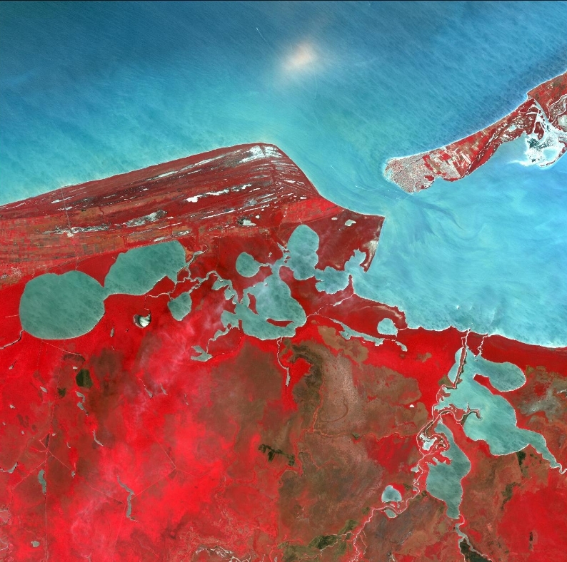
Named after the ancient Mayan Province of Kimpech, the state of Campeche comprises much of the western half of Mexico's Yucatan Peninsula. Rivers in southern Campeche drain into the immense Terminos Lagoon, the entrance to which is protected by a long barrier island, Isla Del Carmen (upper right). In this false-color satellite image the green jungle canopy shows up as bright red. Image courtesy of USGS.
Government
Government Type: Federal republic
The 1917 constitution provides for a federal republic with powers separated into independent executive, legislative, and judicial branches. Historically, the executive has been the dominant branch, with power vested in the president, who promulgates and executes the laws of the Congress. The Congress has played an increasingly important role since 1997, when opposition parties first made major gains. The president also legislates by executive decree in certain economic and financial fields, using powers delegated by the Congress. The president is elected by universal adult suffrage for a 6-year term and may not hold office a second time. There is no vice president.
The Congress is comprised of a Senate and a Chamber of Deputies. Consecutive re-election is prohibited. Senators are elected to 6-year terms, and deputies serve 3-year terms. The Senate's 128 seats are filled by a mixture of direct-election and proportional representation. In the lower chamber, 300 deputies are directly elected to represent single-member districts, and 200 are selected by a modified form of proportional representation from five electoral regions. The 200 proportional representation seats were created to help smaller parties gain access to the Chamber.
Capital: Mexico City - 19.319 million (2009). Mexico City is the second-largest urban agglomeration in the Western Hemisphere, after Sao Paulo (Brazil), but before New York-Newark (US)
Other Major Cities:
- Guadalajara 4.338 million;
- Monterrey 3.838 million;
- Puebla 2.278 million;
- Tijuana 1.629 million (2009)
Administrative divisions: 31 states (estados, singular - estado) and 1 federal district* (distrito federal); Aguascalientes, Baja California, Baja California Sur, Campeche, Chiapas, Chihuahua, Coahuila de Zaragoza, Colima, Distrito Federal*, Durango, Guanajuato, Guerrero, Hidalgo, Jalisco, Mexico, Michoacan de Ocampo, Morelos, Nayarit, Nuevo Leon, Oaxaca, Puebla, Queretaro de Arteaga, Quintana Roo, San Luis Potosi, Sinaloa, Sonora, Tabasco, Tamaulipas, Tlaxcala, Veracruz de Ignacio de la Llave (Veracruz), Yucatan, Zacatecas
Independence Date: 16 September 1810 (declared); 27 September 1821 (recognized by Spain)
Legal System: accepts compulsory International Court of Justice (ICJ) jurisdiction; and accepts International criminal court (ICCt) jurisdiction.
The judiciary is divided into federal and state court systems, with federal courts having jurisdiction over most civil cases and some major felonies. Under the constitution, trial and sentencing must be completed within 12 months of arrest for crimes that would carry at least a 2-year sentence. In practice, the judicial system often does not meet this requirement. Trial is by judge, not jury; however, Mexico is currently implementing an oral, adversarial justice system. Defendants have a right to counsel, and public defenders are available. Other rights include defense against self-incrimination, the right to confront one's accusers, and the right to a public trial. Supreme Court justices are appointed by the president and approved by the Senate. (See "Reforms" below for comments on judicial reform currently underway.)
Environmental international agreements
Mexico is party to agreements on Biodiversity, Climate Change, Climate Change-Kyoto Protocol, Desertification, Endangered Species, Hazardous Wastes, Law of the Sea, Marine Dumping, Marine Life Conservation, Ozone Layer Protection, Ship Pollution, Wetlands, Whaling
Water
Total Renewable Water Resources: 457.2 cu km (2000)
Freshwater Withdrawal: 78.22 cu km/yr (17% domestic, 5% industrial, 77% agricultural)
Per Capita Freshwater Withdrawal: 731 cu m/yr (2000)
Agriculture
Mexico’s agricultural sector accounts for 5% of GDP and employs 13.7% of the work force. Top revenue-producing crops include corn, tomatoes, sugar cane, dry beans, and avocados. Mexico also generates significant revenue from the production of beef, poultry, pork, and dairy products. Implementation of NAFTA has opened Mexico's agricultural sector to the forces of globalization and competition, and some farmers have greatly benefited from greater market access. In particular, fruit and vegetable exports from Mexico have increased dramatically in recent years. However, structural inefficiencies that have existed for decades continue to limit improvements in productivity and living standards for many in the agricultural sector. These inefficiencies include a prevalence of small-scale producers, a lack of infrastructure, inadequate supplies of credit, a communal land structure for many producers, and a large subsistence rural population that is not part of the formal economy. It is estimated that half of Mexico's producers are subsistence farmers and over 60% produce corn or beans, with the majority of these farmers cultivating five hectares or less, although the number of Mexican farmers is steadily decreasing as they seek greater economic opportunities from off-farm employment.
Agricultural products: corn, wheat, soybeans, rice, beans, cotton, coffee, fruit, tomatoes; beef, poultry, dairy products; wood products
Irrigated Land: 63,000 sq km (2008)
Resources
Natural Resources: petroleum, silver, copper, gold, lead, zinc, natural gas, timber
Land Use:
arable land: 12.66%
permanent crops: 1.28%
other: 86.06% (2005)
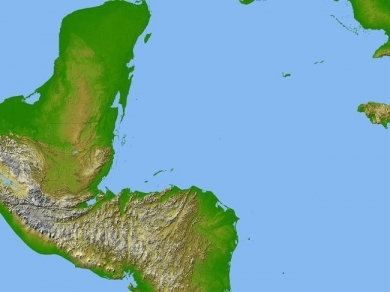
Satellite radar topography image of a portion of Central America. Due to persistent cloud cover, obtaining conventional high-altitude photos of this region is extrordinarily difficult. Radar's ability to penetrate clouds and make 3-D measurements allowed scientists to generate the first complete high-resolution topographic map of the entire region. All of Guatemala, Belize, El Salvador, and Honduras are visible on this image, as well as a considerable portion of southern Mexico (the Yucatan Peninsula). Image courtesy of NASA/JPL/NGA.
Energy
In 2010, Mexico was the seventh-largest oil producer in the world and the second-largest supplier of oil to the United States. State-owned Petroleos Mexicanos (Pemex) holds a constitutionally-established monopoly for the exploration, production, transportation, and marketing of the nation's oil and is one of the largest oil companies in the world. However, oil production has decreased in recent years as production at the giant Cantarell field continues to decline. The oil sector is a crucial component of Mexico's economy; while its relative importance to the general Mexican economy has declined in the long term, the oil sector still generated 14% of the country's export earnings in 2010, according to Mexico's central bank. More importantly, the government relies upon earnings from the oil industry (including taxes and direct payments from Pemex) for 32% of total government revenues. Therefore, any decline in oil production has a direct effect upon the country's overall fiscal balance.
In early 2011, Mexico held licensing rounds for performance-based contracts on oil blocks, allowing participation by foreign oil companies for the first time since the nationalization of the oil industry in 1938. The foreign firms will have no ownership rights over any oil they produce, but they are expected to provide Mexican fields with needed technological improvements.
Economy
Mexico has a free market economy in the trillion dollar class. It contains a mixture of modern and outmoded industry and agriculture, increasingly dominated by the private sector. Recent administrations have expanded competition in seaports, railroads, telecommunications, electricity generation, natural gas distribution, and airports. Per capita income is roughly one-third that of the US; income distribution remains highly unequal.
Mexico is classified by the World Bank as an upper-middle-income country. Poverty is widespread (around 44% of the population lives below the poverty line), and high rates of economic growth are needed to create legitimate economic opportunities for new entrants to the work force. The Mexican economy grew by more than 5% in 2010 after a sharp recession in 2009 during the global economic crisis.
Since the 1994 devaluation of the peso, successive Mexican governments have improved the country's macroeconomic fundamentals. Inflation and public sector deficits are under control, while the current account balance and public debt profile have improved. Mexico’s sovereign debt remains investment-grade, with a stable outlook. Mexico’s tax revenue as a percentage of gross domestic product (GDP) was 17.5% in 2009, the lowest of OECD members.
Mexico is a major recipient of remittances, sent mostly from Mexicans in the United States. Remittances amounted to $21.3 billion in 2010 and are the country’s second-largest source of foreign currency, after oil. Most remittances are used for immediate consumption--food, housing, health care, education--but some collective remittances, sent from a U.S. community of migrants to their community of origin, are used for shared projects and infrastructure improvements. The Government of Mexico participates through its flagship fund-matching program “3X1 Program for Migrants.” The Mexican Government also has implemented social development programs, like Oportunidades, to address the problems of poverty.
Mexico is one the most popular tourist destinations in the world. It attracted 21.3 million international tourists in 2010, making it the tenth-most popular international destination in terms of arrivals. Tourism contributed $11.8 billion to Mexico’s economy in 2010, one of the top sources of foreign exchange for the country.
Since the implementation of the North American Free Trade Agreement (NAFTA) in 1994, Mexico's share of US imports has increased from 7% to 12%, and its share of Canadian imports has doubled to 5%. Mexico has free trade agreements with over 50 countries including, Guatemala, Honduras, El Salvador, the European Free Trade Area, and Japan, putting more than 90% of trade under free trade agreements.
In 2007, during its first year in office, the Felipe Calderon administration was able to garner support from the opposition to successfully pass pension and fiscal reforms. The administration passed an energy reform measure in 2008 and another fiscal reform in 2009. Mexico's GDP plunged 6.5% in 2009 as world demand for exports dropped, asset prices tumbled, and remittances and investment declined.
GDP posted positive growth of 5.4% in 2010 and 3.8% in 2011, with exports - particularly to the United States - leading the way. The administration continues to face many economic challenges, including improving the public education system, upgrading infrastructure, modernizing labor laws, and fostering private investment in the energy sector. Calderon has stated that his top economic priorities remain reducing poverty and creating jobs.
GDP: (Purchasing Power Parity): $1.657 trillion (2011 est.)
GDP: (Official Exchange Rate): $1.185 trillion (2011 est.)
GDP- per capita (PPP): $15,100 (2011 est.)
GDP- composition by sector:
agriculture: 3.9%
industry: 32.8%
services: 63.4% (2011 est.)
Industries: food and beverages, tobacco, chemicals, iron and steel, petroleum, mining, textiles, clothing, motor vehicles, consumer durables, tourism
Trade
Mexico's trade regime is built upon 13 trade agreements with 44 countries, including the United States, Canada, and the European Union. In 2010 it exported nearly $300 billion of goods, led by electronic and other machinery (38% of total), road vehicles and transportation equipment (17.8%), and mining and crude oil (14.6%). Mexico relies heavily on supplying the U.S. market but has also sought to diversify its export destinations. Eighty percent of Mexico’s exports went to the United States in 2010, down from a high of nearly 90% in 2001.
The United States exported $163 billion of goods to Mexico in 2010. Mexico is the United States’ second-largest export market (after Canada) and third-largest trading partner (after Canada and China). Two-way trade (exports plus imports) reached nearly $400 billion in 2010, more than quadruple what it was 20 years ago. Top U.S. exports to Mexico include electronic equipment, motor vehicle parts, and chemicals. Trade matters are generally settled through direct negotiations between the two countries or addressed via World Trade Organization (WTO) or North American Free Trade Agreement (NAFTA) formal dispute settlement procedures. Mexico is an active and constructive member of the World Trade Organization, the G-20, and the Organization for Economic Cooperation and Development.
Mexico is making progress in its intellectual property rights enforcement efforts, although piracy and counterfeiting rates remain high. Mexico appeared on the Watch List in the 2011 Special 301 report. The U.S. continues to work with the Mexican Government to implement its commitment to improving intellectual property protection.
Foreign Investment
Foreign direct investment (FDI) in Mexico for 2010 was $17.7 billion, up slightly from 2009 but still below the peak levels of the mid-2000s. The global economic slowdown in 2008 and 2009 caused a significant decline in FDI. Portfolio investment totaled $37.1 billion in 2010. Most portfolio investment was in local bond issuances.
Transportation and Communications
The World Economic Forum ranks Mexico 79th globally on the overall quality of its infrastructure (out of 139 countries). A National Infrastructure Plan of $233 billion is designed to raise the coverage, quality, and competitiveness of the country’s infrastructure assets.
Mexico's land transportation network is one of the most extensive in Latin America with 356,000 kilometers of paved roads. In terms of road density, however, Mexico has one of the lowest rates among the major economies in the region. Three major private companies operate Mexico’s 27,000-km railroad network.
Mexico's sea ports have experienced a boom in investment and traffic following a 1993 law that privatized the port system. Mexico's ports moved 3.3 million 20-foot container equivalent units (TEU) in 2008 and 2.9 million TEUs in 2009. Manzanillo is the largest container port, followed by Veracruz and Altamira. Several dozen international airlines serve Mexico, with direct or connecting flights from most major cities in the United States, Canada, Europe, Japan, and Latin America. Most Mexican regional capitals and resorts have direct air services to Mexico City or the United States. In 2010, 24.1 million air passengers visited Mexico.
The telecommunications sector is dominated by Telmex, the former state-owned monopoly, and its mobile telephone spinoff, America Movil. Several international companies compete in the sector with limited success. The fixed-line teledensity rate in Mexico (18%) is below the average for Latin America. Wireless penetration is much higher (more than 75%), with 91.3 million wireless subscribers in 2010, although many of these customers rely on prepaid cards or use their phones to receive calls only. In 2010, 35 million Mexicans had some form of Internet access.
Further Reading
- Wilkinson, C., Souter, D. (eds) , 2008 , Status of Caribbean Coral Reefs After Bleaching and Hurricanes in 2005 .
- Website of the Government of Mexico
- Sito Oficial del Gobierno de México


