Belize
Belize (formerly British Honduras) is a nation of a third-of-a-million people in Central America bordering Mexico, Guatemala and the Caribbean Sea. It is the only country in Central America without a coastline on the North Pacific Ocean.
Chief environmental issues include:
- deforestation;
- coral reef damage from overfishing and raw sewage discharge (Gibson et al, 1998)
- agricultural runoff, solid waste disposal and inadequate sewage treatment.

Belize traditionally maintains a deep interest in the environment and sustainable development. In August 2001, the governments of the U.S. and Belize, in conjunction with The Nature Conservancy, announced a debt-for-nature swap under the Tropical Forest Conservation Act. The $5.5 million in appropriated funds were combined with $1.3 million in private funds raised by The Nature Conservancy to reduce Belize’s official debt to the U.S. by half. Under the agreement, the Government of Belize issued obligations to generate approximately $9 million in local currency payments to help a consortium of four local non-governmental organizations (NGOs) administer conservation activities in protected areas.
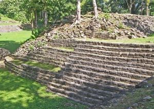
Belize was the site of several Mayan city states until their decline at the end of the first millennium A.D.
The British and Spanish disputed the region in the 17th and 18th centuries; it formally became the colony of British Honduras in 1854.
Territorial disputes between the United Kingdom and Guatemala delayed the independence of Belize until 1981. Guatemala refused to recognize the new nation until 1992. Guatemala persists in its territorial claim to half of Belize, but agrees to Line of Adjacency to keep Guatemalan squatters out of Belize's forested interior.
Tourism has become the mainstay of the economy.
Current concerns include an unsustainable foreign debt, high unemployment, illegal immigration from Guatemala, growing involvement in the South American drug trade, high urban crime, and increasing incidences of HIV/AIDS.
Contents
Geography
|
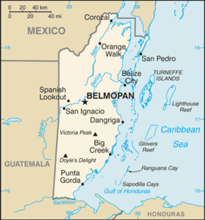
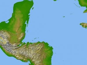
Location: Central America, bordering the Caribbean Sea, between Guatemala and Mexico Geographic Coordinates: 17 15 N, 88 45 W Area: 22,966 sq km (22,806 sq km of land, 160 sq km of water) Arable land: 3.05% Land Boundaries: 516 km (Guatemala 266 km, Mexico 250 km) Belize and Mexico are working to solve minor border demarcation discrepancies arising from inaccuracies in the 1898 border treaty Coastline:386 km Maritime Claims: Territorial sea: 12 nm in the north, 3 nm in the south; note - from the mouth of the Sarstoon River to Ranguana Cay, Belize's territorial sea is 3 nm; according to Belize's Maritime Areas Act, 1992, the purpose of this limitation is to provide a framework for negotiating a definitive agreement on territorial differences with Guatemala exclusive economic zone: 200 nm Natural Hazards: Frequent, devastating hurricanes (June to November) and coastal flooding (especially in south). Terrain: The topography of the swampy coastal plain is level; low mountains in south; higher Maya Mountains in the east of the country. Climate: Tropical; very hot and humid; rainy season (May to November); dry season (February to May). |

Ecology and Biodiversity
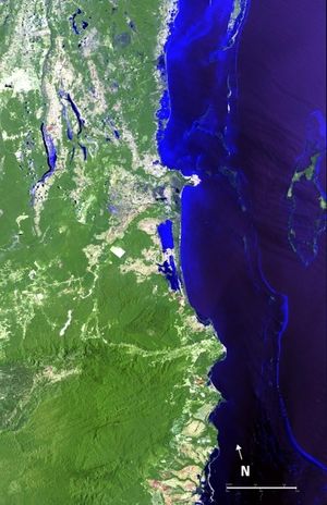
The pine forests of Belize on Central Americas northwestern Caribbean coast represent various relatively preserved fragments of vegetation as well as a considerable abundance of fauna. They represent one of the few examples of lowland and premontane pine forests in the Neotropics, where the predominant tree species is Pinus caribaea var. hondurensis (pine, ocote), which requires periodic low intensity burns for its regeneration. The vegetation is adapted to the xeric, acidic and nutrient-poor conditions that occur primarily in the dry season. The coastal areas of the ecoregion, with vegetation that is less dense, are threatened due to selective forestry operations and the expansion of citrus fruit and banana plantations. Coral reef communities in Belizean coastal waters are threatened by overfishing and discharge of untreated sewage to the ocean.(Arrivillaga & Garcia, 2004) Belize is also a part of the Mesoamerica Biodiversity Hotspot. |
Protected Areas
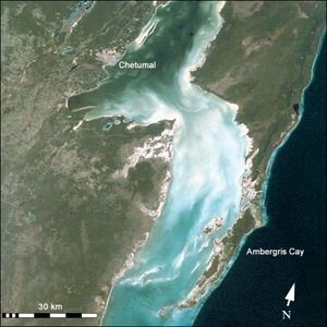
The [../150471/[Belize] Barrier ] platform lies on the Atlantic-Caribbean coast of Belize, and extends 260 kilometres (km) from the border with Mexico to the north, to near the Guatemalan border to the south.
People and Society
Population: 327,719 (July 2012 est.)
Belize is the most sparsely populated nation in Central America. It is larger than El Salvador and compares in size to the State of Massachusetts. Slightly more than half of the population lives in rural areas. About one-fifth live in Belize City, the principal port, commercial center, and former capital. More than one-third of the population is comprised of persons younger than 14 years of age.
Most Belizeans are of multiracial descent. About 43.7% of the population is of mixed Mayan and European descent (mestizo); 29.8% are of African and Afro-European (Creole) ancestry; about 11.0% are Mayan; and about 6.6% are Afro-Amerindian (Garifuna). The remainder, about 8.9%, includes European, East Indian, Chinese, Middle Eastern, and North American groups.
Ethnic groups: mestizo 48.7%, Creole 24.9%, Maya 10.6%, Garifuna 6.1%, other 9.7% (2000 census)
Age Structure:
0-14 years: 36.8% (male 60,327/female 57,933)
15-64 years: 59.6% (male 96,886/female 94,605)
65 years and over: 3.5% (male 5,404/female 5,960) (2011 est.)
Population Growth Rate: 2.011% (2012 est.)
Birthrate: 26.02 births/1,000 population (2012 est.)=
Death Rate: 5.91 deaths/1,000 population (July 2012 est.)
Net Migration: 0 migrant(s)/1,000 population (2012 est.)
Life Expectancy at Birth: 68.28 years
male: 66.61 years
female: 70.04 years (2012 est.)
Total Fertility Rate: 3.15 children born/woman (2012 est.)
Languages: Spanish 46%, Creole 32.9%, Mayan dialects 8.9%, English 3.9% (official), Garifuna 3.4% (Carib), German 3.3%, other 1.4%, unknown 0.2% (2000 census)
English, the official language, is spoken by virtually all except the refugees who arrived during the past decades. Spanish is the native tongue of about 50% of the people and is spoken as a second language by another 20%. The various Mayan groups still speak their indigenous languages, and an English-Creole dialect similar to the Creole dialects of the English-speaking Caribbean Islands is spoken by most. The rate of functional literacy is 76%. About 50% of the population is Roman Catholic; the Anglican Church and other Protestant Christian groups account for most of the remaining 50%. Mennonite settlers number about 8,500.
Literacy: 76.9% (2000 census)
Urbanization: 52% of total population (2010) growing at an annual rate of change of 2.7% (2010-15 est.)
History
The Mayan civilization spread into the area of Belize between 1500 BC and AD 300 and flourished until about AD 1200. Several major archeological sites--notably Caracol, Lamanai, Lubaantun, Altun Ha, and Xunantunich--reflect the advanced civilization and much denser population of that period. European contact began in 1502 when Christopher Columbus sailed along the coast. The first recorded European settlement was established by shipwrecked English seamen in 1638. Over the next 150 years, more English settlements were established. This period also was marked by piracy, indiscriminate logging, and sporadic attacks by Indians and neighboring Spanish settlers.
Great Britain first sent an official representative to the area in the late 18th century, but Belize was not formally termed the "Colony of British Honduras" until 1840. It became a crown colony in 1862. Subsequently, several constitutional changes were enacted to expand representative government. Full internal self-government under a ministerial system was granted in January 1964. The official name of the territory was changed from British Honduras to Belize in June 1973, and full independence was granted on September 21, 1981.
Government
Belize is a parliamentary democracy based on the Westminster model and is a member of the Commonwealth. Queen Elizabeth II is head of state and is represented in the country by Governor General Colville N. Young, Sr., a Belizean and Belize's second governor general. The primary executive organ of government is the cabinet, led by a prime minister (head of government). Cabinet ministers are members of the majority political party in parliament and usually hold elected seats in the National Assembly concurrently with their cabinet positions.
The National Assembly consists of a House of Representatives and a Senate. The 31 members of the House are popularly elected to a maximum 5-year term. The governor general appoints the Senate's 12 members. Six are appointed in accordance with the advice of the prime minister, 3 with the advice of the leader of the opposition. The Belize Council of Churches and the Evangelical Association of Churches, the Belize Chamber of Commerce and Industry and the Belize Business Bureau, and the National Trade Union Congress and the Civil Society Steering Committee each advise the Governor General on the appointment of one senator each. (A majority of Belizeans who decided to participate in the referendum held along with the national elections on February 7, 2008 voted in favor of a change from the current appointed Senate to an elected one. This change will take effect during the next general election, which is slated to take place by early 2013.) The Senate is headed by a president, who is a non-voting member appointed by the governing party.
Government Type: Parliamentary democracy and a Commonwealth realm
Capital: Belmopan - 20,000 (2009)
Administrative divisions: 6 districts; Belize, Cayo, Corozal, Orange Walk, Stann Creek, Toledo
Independence Date: 21 September 1981 (from the UK)
Legal System: English common law. Belize has not submitted an International Court of Justice (ICJ) jurisdiction declaration; but accepts International criminal court (ICCt) jurisdiction. Members of the independent judiciary are appointed. The judicial system includes local magistrates, the Supreme Court, and the Court of Appeal. In 2001 Belize joined with most members of the Caribbean Common Market (CARICOM) to establish a "Caribbean Court of Justice," which was inaugurated on April 16, 2005. In June 2010, the Belizean Government made the Caribbean Court of Justice the highest court for Belize, replacing the Privy Council in London.
International Environmental Agreements
Belize is party to international agreements on Biodiversity, Climate Change, Climate Change-Kyoto Protocol, Desertification (Deforestation), Endangered Species, Hazardous Wastes, Law of the Sea, Ozone Layer Protection, Ship Pollution, Wetlands, and Whaling.
Water
Belize is very rich in surface and groundwater resources. Water quality at higher elevation locations in the Maya Mountains is quite good, but lower elevation regions of the Belize River are relatively poor due to agricultural discharges and effluent of untreated sewage. At present, however, total water resources cannot be evaluated because the existing data are limited, in particular with respect to groundwater availability.
Total Renewable Water Resources: 18.6 cu km (2000)
Freshwater Withdrawal: 0.15 cu km/yr (7% domestic, 73% industrial, 20% agricultural)
Per Capita Freshwater Withdrawal: 556 cu m/yr (2000)
Agriculture
Forestry was the only economic activity of any consequence in Belize until well into the 20th century, when the supply of accessible timber began to dwindle. Cane sugar then became the principal export. Exports were augmented by expanded production of citrus, bananas, seafood, and apparel. The agricultural sector suffered from damage caused by hurricanes that struck Belize in late 2007 and late 2010 and heavy flooding in mid-June and October of 2008. The farmed shrimp industry, a chief export earner until 2005, continues to decline.
Although about 1,998,230 acres (or 38% of the total land area) are considered potentially suitable for agricultural use, only approximately 10% to 15% is in use in any one year. About half of this is under pasture, with the remainder in a variety of permanent and annual crops. The traditional system of "milpa" (shifting cultivation) involves the annual clearing of new land for crop production; however, increasing numbers of farmers are making permanent use of cleared land by mechanical means. A tax is levied on the unimproved "value" of the land. To curb land speculation, the government enacted legislation in 1973 that requires non-Belizeans to complete a development plan on land they purchase before obtaining title to plots of more than 10 acres of rural land or more than one-half acre of urban land.
Agricultural products: bananas, cacao, citrus, sugar; fish, cultured shrimp; lumber
Irrigated Land: 40 sq km (2008)
Economy
Tourism is the number one foreign exchange earner in this small economy, followed by exports of marine products, citrus, cane sugar, bananas, and garments.
The government's expansionary monetary and fiscal policies, initiated in September 1998, led to GDP growth averaging nearly 4% in 1999-2007.
Oil discoveries in 2006 bolstered this growth. Exploration efforts have continued and production has increased a small amount.
In February 2007, the government restructured nearly all of its public external commercial debt, which helped reduce interest payments and relieved some of the country's liquidity concerns.
Belize was adversely impacted by the global downturn in 2009. Growth slipped to 0% in 2009, but the economy recovered modestly in 2010. GDP growth reached 2.7% in 2010, and 2.5% in 2011, supported by government services and commerce. However, Belize's economic performance is highly susceptible to external market changes. Tourism is Beilze’s number one foreign exchange earner, followed by exports of crude oil, marine products, citrus, sugar, bananas, and garments. Because of the uncertain future of these traditional exports, efforts are being made toward agricultural diversification. Agriculture currently provides some 71% of the country's total foreign exchange earnings and employs approximately 29% of the total labor force.
Domestic industry is limited, constrained by relatively high-cost labor and energy and a small domestic market. Some 185 U.S. companies have operations in Belize. Tourism attracts the most foreign direct investment, although U.S. investment also is found in the telecommunications and agricultural sectors.
A combination of natural factors--climate, the longest barrier reef in the Western Hemisphere, numerous islands, excellent fishing, safe waters for boating, jungle wildlife, and Mayan ruins--support the thriving tourist industry. The Government of Belize has designated tourism as one of its major development priorities.
Belize’s banking system reported a surge in nonperforming loans (NPLs) in 2010, equivalent to 16.1% of total loans by the end of 2010, although by mid-2011 the number had declined slightly to 15.2%. While banks comply with current regulations, provisioning remains low by international standards, covering less than 16% of NPLs. The increase in NPLs has been largely concentrated in three banks (two domestic banks and one offshore), which account for over 40% of deposits in the banking system.
Infrastructure
A major constraint on the economic development of Belize continues to be the scarcity of infrastructure investments. As part of its financial austerity measures started in late 2004, the government froze expenditures on several capital projects. Although electricity, telephone, and water utilities are all relatively good, Belize has the most expensive electricity in the region. Hydroelectric facilities at Vaca Dam and a bagasse cogeneration plant at a sugar cane processing facility were brought fully online in 2010 in an effort to increase domestic capacity for electricity generation. Large tracts of land, which would be suitable for development, are inaccessible due to lack of roads. Some roads, including sections of major highways, are subject to damage or closure during the rainy season. Ports in Belize City, Dangriga, and Big Creek handle regularly scheduled shipping from the United States and the United Kingdom, although draft is limited to a maximum of 10 feet in Belize City and 15 feet in southern ports. American Airlines, Continental Airlines, U.S. Airways, Delta Airlines, and TACA provide international air service to gateways in Dallas, Houston, Miami, Charlotte, Atlanta, and San Salvador.
Trade
Belize continues to rely heavily on foreign trade. World commodity price fluctuations and preferential trading agreements, especially with the United States and the European Union (cane sugar) and the United Kingdom (bananas), have greatly impacted Belize's economic performance. European Union (EU) and U.K. preferences have been vital for the expansion and prosperity of the sugar and banana industries.
According to the World Trade Organization, imports for 2010 were $709 million, while exports were $325 million. The United States continues to be Belize's number-one trading partner. In 2010, the United States provided 47.9% of Belizean imports and accounted for 49.1% of Belize's exports. Other major trading partners include Mexico, the European Union, Central America, Japan, and China. Belize aims to stimulate the growth of commercial agriculture through CARICOM. However, Belizean trade with the rest of the Caribbean is small compared to that with the United States and Europe.
With weak economic growth and a large public debt burden, fiscal spending is likely to be tight.
A key government objective remains the reduction of poverty and inequality with the help of international donors.
Although Belize has the second highest per capita income in Central America, the average income figure masks a huge income disparity between rich and poor. The 2010 Poverty Assessment shows that more than 4 out of 10 people live in poverty.
The sizable trade deficit and heavy foreign debt burden continue to be major concerns.
GDP: (Purchasing Power Parity): $2.754 billion (2011 est.)
GDP: (Official Exchange Rate): $1.5 billion (2011 est.)
GDP- per capita (PPP): $8,300 (2011 est.)
GDP- composition by sector:
agriculture: 9.7%
industry: 19.8%
services: 58.7% (2011 est.)
Industries: garment production, food processing, tourism, construction, oil
Natural Resources: arable land potential, timber, fish, hydropower
Currency: Belizean dollars (BZD)
References
- Arrivillaga, A. and M. A. Garcia , 2004 , Status Of Coral Reefs Of The Mesoamerican Barrier Reef Systems Project Region, And Reefs Of El Salvador, Nicaragua And The Pacific Coasts Of Mesoamerica. . p: 473-492. in C. Wilkinson (ed.). Status of coral reefs of the world: 2004. Volume 2. Australian Institute of Marine Science, Townsville, Queensland, Australia. 557 p
- J.Gibson, M. McField and A. Fields (1998) Coral reef management in Belize: an approach through integrated coastal zone management. Ocean & Coastal Management. Volume 39, Issue 3, July 1998, Pages 229-244 = Coral reef management in Belize: an approach through integrated coastal zone management = Author links open overlay panelJGibsona1MMcFielda2SWellsa3