Water profile of Belize
Contents
Geography and population
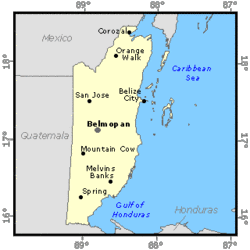
The water profile of Belize generally is summarized by an adequate supply of surface and groundwater, chiefly as a benefit from the moderate human population density, which demographic feature differentiates Belize from most of its Central American nieghbour nations. Belize (17°15' North, 88°45' West) is located in Central America, bordering the Caribbean Sea, between Guatemala and Mexico. North to South, Belize is 274 kilometers (km) long and 109 km wide east to west. The country is divided into six administrative districts: Belize, Corozal, Orange Walk, Cayo, Stann Creek and Toledo. The total area of Belize is 2,296,560 hectares (ha) that includes 154,000 ha of lagoons and 69,000 ha of approximately 450 small islands (known as cayes).
The coastal areas are lowland plains, with much of the coastline covered with mangrove swamps. The Maya Mountains (300 to 1000 meters (m) in altitude) occupy the south-center and dominate much of the remainder of the country. They rise steeply to a maximum of 1,120 m at Victoria Peak in the Cockscomb Range, and slope down to the Vaca Plateau in the West. Belize has the second longest coral barrier reef in the world at 220 km running almost the entire length of the coastline.
The last population census of 1992 calculated the total population as 199,000 inhabitants, with one of the lowest population densities in Latin America. Belize has a diverse population: Mestizo, Creole, Garífuna, Caribbean, Maya Kekchi, Maya Mopán, Mennonite, Yucatec, etc. Belize's annual population growth is about 2.6%.
Belize is a unique case of a very small country with a rich endowment of natural resources of global importance: its large and still relatively intact tropical forests and its almost pristine coral reef. Some 65-68% of the country is classified as forest, with 35.5% held by the government under Forest Reserves and Protected Areas Status with a rich biodiversity.
Agriculture has for a long time made up a large part of Belize's output and consists mainly of three export crops: sugar cane, citrus and bananas. These agricultural products are the basic inputs required by agro-based industries that produce most of the manufacturing output in Belize. In addition, small farmers produce mainly maize, beans and rice. The gross domestic product (GDP) in 1997 was US$690 million, of which agriculture contributed 23.5%. Largely as a result of Belize's preferential trade arrangements with Europe and the United States, the production of sugar, citrus and bananas has grown rapidly since the mid-1980s.
Climate, water resources and water use
Climate
Belize has a subtropical climate with temperatures ranging from 22ºC to 31ºC in the coast and from 16ºC to 18ºC in the mountains, the coldest months being November and January. Annual rainfall varies from 1500 millimeters (mm) in the North to 4,000 mm in the South. A dry season extends from January/February to May, followed by a rainy season that peaks in July. In November and December, agricultural activities are commonly restricted due to high water saturation levels in the soil. Winds from the East and Southeast prevail from February to September, while winds from the North and Northeast dominate in winter. Annual evaporation in Belize District is 1750 mm. Belize is within the area of the Caribbean commonly affected by hurricanes, which on average occur once every five years.
Water resources
Belize is very rich in surface and groundwater resources. At present, however, total water resources cannot be evaluated because the existing data are limited, in particular with respect to groundwater availability.
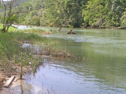
Surface water resources appear to be abundant all over the country except on the Vaca Plateau, where streams disappear in the porous limestone. The northern rivers show meandering streams while the southern have smaller basins and flow more rapidly into the sea. The sum of the quantified river discharges is 15 km3/yr, occupying 59% of the territory. Five of the rivers initiate in Mexico and Guatemala. The Rio Hondo forms the northern boundary of the country with Mexico and, in the south, the Sarstoon River is the boundary with Guatemala.
The existing aquifers and their annual recharge rate have not been quantified. Generally, groundwater is available throughout the less mountainous areas of Belize and favorable yield characteristics can be attributed to geology and climatic conditions. The northern region consists of calcareous sediments that have shown high permeabilities. In the South where limestones are found, similar groundwater yield conditions are indicated, while the shales and slates are naturally poorly permeable and therefore have low capacity for groundwater extraction.
Sporadic occurrences of poor quality groundwater occur. High concentrations of chloride are found along the coast and along rivers that are subject to tidal effects. Chloride waters are evident in some inland wells in the northern half of the country, likely as a result of the dissolution of salts within the calcareous sediments. Large concentrations of hardness and sulfate are evident in some areas, particularly the Corozal District. While quality problems do exist, it has been Belize's experience that acceptable quality water can usually be located around the country for central supply systems with sufficient test drilling. Poor quality groundwater can be expected during the dry season when freshwater recharge from precipitation is negligible, particularly in the North where it extends for three to four months.
Lakes and dams
Belize relies on oil imports and Mexican power for the provision of electricity. As a means of import substitution and reducing the average cost of supplying power, proposals have repeatedly been made for hydroelectric development within the country. Belize is well endowed with potential sites for the development of large and small hydroelectric projects, with eight such sites having been identified. A number of small privately owned plants presently exist. A major hydroelectric project called "El Mollejón" at Vaca Falls at the confluence of the Rio On and the Macal River is currently under operation. This dam generates 25.2 megawatts (MW) of electricity for national distribution.
Water Use
A chief use of water is in industrial processes. The total water withdrawal of 95 million m3/yr is negligible compared to surface water resources. Domestic water consumption per capita is about 240 to 280 liters per day in urban areas and about 160 liters per day in rural areas. This is about equal to the amount consumed in industrialized countries.
Seventy percent of the total water used in urban areas is surface water. Groundwater is also used as a source of drinking water in the cities of the Corozal, Orange Walk, Cayo and Toledo Districts and in some rural areas of Toledo and Cayo. Data on water sources used by industry are not available. However, it is assumed that surface water is also its main water source. The amount of water used for irrigation is estimated to be less than one percent of total water withdrawal.
Water quality in urban areas is good by regional standards, and is constantly monitored by the Water and Sewerage Authority (WASA). In rural areas, however, the water quality, mainly in the districts of Toledo, Stann Creek and Cayo, is not satisfactory: full water purification takes place only in the systems that are connected to urban WASA systems (about 30%).
A rough estimate made in 1994 considered that approximately 39% of the population was served with adequate sanitation facilities.
Irrigation and Drainage
The country has two major agro-climatic zones: the northern and the southern. The northern zone is relatively flat, with considerable areas of swampland on the coastal plain. Its average annual rainfall is about 1,300 mm, and its calcareous soils are suitable for cultivation of a wide variety of crops. These soils may, however, change abruptly to acidic soils in certain areas. The southern zone encompasses the central mountains and a flat to undulating coastal belt. The siliceous soils of the mountains are not suited for agriculture. The high level of soil acidity and poor drainage conditions constitute important constraints to crop production. In total, only 16% of the land is suitable for sustained agricultural production without skilled management.
Two main farming systems can be distinguished: Milpa and commercial farming. Milpa farming is based on slash-and-burn practices and is usually carried out on hillsides. It is the basic system used to produce food for domestic consumption: maize, grown during the wet season, and a variety of other crops (including beans, vegetables, root crops and plantains) grown in the subsequent dry season. Commercial farming includes export crops such as sugar cane, oranges, grapefruit, banana and cocoa.
Irrigation in Belize has been marginal because of its climatic and social conditions. Irrigation and drainage information is non-existent. Public irrigation and drainage systems are non-existent and only a few private irrigation systems were developed in the 1990s, where surface and sprinkler irrigation are being used for citrus and banana production, surface irrigation for rice, and micro-irrigation for papaya production. It is expected that in the coming years more banana plantations will be irrigated, so that the estimated water withdrawal may be in the order of 240,000 m3/yr.
Institutional Environment
There is not a unique and sole authority responsible for water resources in Belize. The various Government agencies involved are:
- Ministry of Natural Resources
- The Water and Sewerage Authority (WASA) is responsible for maintaining and developing waterworks, increasing and improving the water supply and promoting the conservation and proper use of water resources in the country
- The Rural Water Supply and Sanitation Department is responsible for providing drinking water and sanitation in the rural areas, supervised by WASA
- The Land Utilization Authority is responsible for the effects of land use on water and natural resources.
- Ministry of Works implements infrastructure projects such as drainage, bridges, fluvial transport and maintenance of canals
- Ministry of Energy and Communications
- The National Service of Meteorology is responsible for the monitoring of climatic and hydrologic conditions
- The General Direction of Electricity Supply provides licenses and control of hydroelectric power
The legal framework in water resources, as shown above, is dispersed and segmented. Certain aspects are taken into consideration twice and others none, such as groundwater use and management that is not a specific task of any institution. Irrigation is not considered in the Government program.
Trends in Water Resources Management
Population pressure is negligible and tourism is becoming an important source of income in Belize. Belize, in general, has plenty of water resources of good quality. Yet conflicts over contamination are starting between unrestricted industrial waste and drinking water supply. Hence, the major obstacle for the development and protection of water resources in Belize is the lack of a unique authority responsible for water resources. Joint efforts are being made to create a National Water Commission, but have not yet been successful.
Further reading
- Water profile of Belize, Food and Agriculture Organization.
- World Factbook: Belize, Central Intelligence Agency.
- Central Statistical Office. 1998. Abstract of Statistics, Belize, Annual Report. Central Statistical Office, Ministry of Finance, Government of Belize. Belize.
- FAO. 1994. Water Resources Management, Policy, Planning and Organization. FAO Technical Cooperation Programme, Government of Belize. Rome.
- IICA. 1995. Belize, Agricultural Sector Study. Centre for Programme and Investment Projects, Inter- American Institute for Cooperation on Agriculture (IICA). 1995, IICA Editorial Service and Print Shop. San José. Costa Rica.
- King, R.B., Prats, J.H., Warner P. and Zisman, S.A. 1993. Agricultural Development Prospects in Belize, Bulletin No. 48, Natural Resources Institute, United Kingdom.
- Ministry of Natural Resources, Belize. 1994. The Land Use of Belize 1989 / 1992. Lands and Survey Department, Land Information Centre, Government of Belize. Belize.
- Ministry of Tourism and the Environment. 1996. National Environmental Action Plan. Government of Belize. Belize.
- UNICEF-PAHO. 1996. Situation Analysis of Rural Water Supply and Sanitation in Belize. UNICEF / Pan American Health Organization. Belize.
| Disclaimer: This article is taken wholly from, or contains information that was originally published by, the Food and Agriculture Organization. Topic editors and authors for the Encyclopedia of Earth may have edited its content or added new information. The use of information from the Food and Agriculture Organization should not be construed as support for or endorsement by that organization for any new information added by EoE personnel, or for any editing of the original content. |