Tehuantepec-El Manchon mangroves
Mangrove associations have long been recognized as good soil retainers and promoters of continuous soil formation for terrestrial communities associated with mangroves. Mangroves also promote and maintain the biodiversity of terrestrial and aquatic environments by preventing erosion of the coast. CONABIO has identified El Triunfo-La Encrucijada-Palo Blanco as a terrestrial priority site within this ecoregion.
An important bird area has also been identified called La Encrucijada.
Although mangrove ecoregions are similar, this ecoregion holds some of the tallest mangrove trees, a species of yellow mangrove that is not widely distributed, serves as a nursery to fish and invertebrates, and provides refuge for many endangered animals.
Location and General Description
These mangroves are situated in the western portion of Chiapas, running northwest southwest on the Pacific Coastal Plain, parallel to the vast Sierra Madre de Chiapas. The climate is tropical with abundant summer rains, which make this ecoregion one of the wettest in the state of Chiapas and in Mexico, with 2500-3000 millimeters (mm) of annual rainfall. The coastal plain is composed of clay and sandy sediments, with abundant metamorphic rocks. Most of the area is flat, but some low elevations allow the rivers Vado Ancho, Cintalapa, and Guerrero to continue their route to sea. Soils are of a clay-sand nature, deep with abundant organic matter.
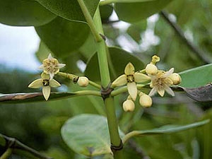
Red mangrove (Rhizophora mangle), white mangrove (Laguncularia racemosa), yellow mangrove (R. harrisonii) and black mangrove (Conocarpus erectus) trees, as well as water zapotón (Pachira aquatica) dominate the tree species in this ecoregion. Some fruit trees including Cynometra petusa, chicozapote, fig trees, and guanacaste grow in association with mangrove trees, as do other plant aggregations, including [[coast]al] scrub, tule (Typha spp.), coastal dune vegetation, and palm trees.
Biodiversity Features
The mangroves on the Pacific Coast of Chiapas have been recognized as some of the tallest mangroves in Mexico, with trees reaching heights of 25 meters (m). They are also home to the unique yellow mangrove tree (Rhizophora harrisonnii), a species that was originally thought to be exclusive to Ecuador and Costa Rica. According to CONABIO, the Soconusco area, in which this ecoregion is included, has a high diversity of plant, bird, fish, and crustacean communities.
The most notable wildlife feature of this ecoregion is its avifauna with large resident, winter and migrant populations. This ecoregion's avifauna is impressive enough to warrant its listing by Stattersfeild et al. as an endemic bird area. Three restricted range species enter this mangrove ecoregion including the white-bellied chachalaca (Ortalis leucogastra), Pacific parakeet (Aratinga strenua) and giant wren (Campylorhynchus chiapensis). Each year, the Pacific coast of Chiapas receives thousands of migrant birds coming from colder regions in Canada and the U.S.A. to spend the winter feeding on the diversity of invertebrates and fish inhabiting the mangroves. Winter residents of this ecoregion include American white pelican (Pelecanus erythrorhynchos), anhinga (Anhinga anhinga), snowy egret (Egretta thula), wood stork (Mycteria americana), blue-winged teal (Anas discors), peregrine falcon (Falco peregrinus), American coot (Fulica americana), plumbeous kite (Ictinia plumbea) and northern shoveller (Anas clypeata). Year round residents include rare species such as black-collared hawk (Busarellus nigricollis), grey-necked wood-rail (Aramides cajanea), least grebe (Tachybaptus dominicus) and Black-Crowned Night Herons (Nycticorax nycticorax).
Mammals and reptiles also add to the diversity of this mangrove ecoregion. There are at least three species of crocodile like reptiles including Crocodylus acutus, Crocodylus moreletti and Caimen crocodylus with a subspecies that is endemic to Chiapas, C. crocodylus chiapasius. Additional reptiles represented in this ecoregion are species such as crucilla turtle (Staurotypus salvinii), black turtle (Trachemys scripta gaigae) and yellow-headed turtle (Kinosternon cruentatum). Mammals in the mangroves are not uncommon; however, many mammals utilize the mangrove ecosystem for resources such as food, shelter and to escape from conditions outside of the ecoregion which may be unfavorable. Although according to CONABIO black-handed spider monkey (Ateles geoffroyi), tayra (Eira barbara), greater grisón (Galictis vittata), ocelot (Leopardus pardalis), nutria (Lutra longicaudis), jaguar (Panthera onca), puma (Puma concolor) and Baird's Tapir (Tapirus bairdii) do live in this ecoregion.
Current Status
Mangroves have been gradually eliminated due to their potential as sources of wood for human use. There is no information on how well preserved the region is or how intact the habitat remains, but federal protection is being carried out as part of "La Encrucijada" Ecological Reserve. Despite many federal protected areas, less than 10% of the state is being protected. The management plan for "La Encrucijada" Ecological Reserve addresses the issues necessary for the protection and preservation of the tallest mangroves in Mexico.
Types and Severity of Threats
Dumping of organic and inorganic waste threatens the survival of many aquatic species and others that simply utilize the products of these mangroves. Development both residential and commercial is threatening this ecosystem due to the human population growth as well as tourism, which could displace mangrove communities. Economic and social problems have forced villagers to overexploit animal species through over hunting and collection for the wildlife trade including several mammals, marine species and reptiles such as turtles and iguanas. As a result, these species have acquired endangered status. Immediate management and planning of conservation strategies is required for nearly the entire state of Chiapas. Chiapas is one of the richest and most biologically diverse places in Mexico however if agricultural expansion, shrimp farming, freshwater diversion, logging and road construction activities continue to threaten this mangrove ecoregion diversity will suffer.
Justification of Ecoregion Delineation
Classification and linework for all mangrove ecoregions in Latin America and the Caribbean follow the results of a mangrove ecoregion workshop and subsequent report.
Additional Information on this Ecoregion
- For a shorter summary of this entry, see the WWF WildWorld profile of this ecoregion.
- To see the species that live in this ecoregion, including images and threat levels, see the WWF Wildfinder description of this ecoregion.
- World Wildlife Fund Homepage
Further Reading
- Alvarez del Toro, M. 1993. Pages 9-15 in M. Alvarez del Toro, T.G. Cabrera-Cachón, C.A. Guichard-Romero, A. Ramírez-Velázquez, and G.J. Cartas-Heredia, editors. Chiapas y su Biodiversidad. Gobierno del Estado de Chiapas, México.
- Arriaga, L., J.M. Espinoza, C. Aguilar, E. Martínez, L. Gómez y E. Loa (coordinadores). 2000. Regiones terrestres prioritarias de México. Escala de trabajo 1:1 000 000. Comisión Nacional para el Conocimiento y uso de la Biodiversidad. México.
- Benitez, H., C. Arizmendi y L. Marquez. 1999. Base de datos de las AICAS. CIPAMEX, CONABIO, FMCN y CCA. Mexico.
- Comision Nacional Para el Conocimiento y Uso de la Biodiversidad (CONABIO) habitat and landuse classification database derived from ground truthed remote sensing data Insitituto Nacional de Estastica, Geografia, e Informática (INEGI)
- CONABIO. 1998. Regiones Hidrológicas Prioritarias. Fichas Técnicas y Mapa. CONABIO, México.
- CONABIO2. 1998. Áreas de Importancia para la Conservación de las Aves y Mapa. CONABIO, Mexico.
- Ecoregional Workshop: A Conservation Assessment of Mangrove Ecoregions of Latin America and the Caribbean. 1994. Washington D.C., World Wildlife Fund.
- Gobierno del Estado de Chiapas, Instituto de Historia Natural and The Nature Conservancy. 1993. Plan Operativo 1993, Reserva Ecológica "La Encrucijada". Gobierno del Estado de Chiapas and The Nature Conservancy, Mexico and U.S.A.
- Junio, C.A. 1982. Mapa de cobertura y uso actual de la tierra Republica de Guatemala. Instituto Geografico Nacional Guatemala, Guatemala City, Guatemala.
- Miranda, F. 1998. La Vegetación de Chiapas. Gobierno del Estado de Chiapas, México.
- Olson, David M., Eric Dinerstein, Gilberto Cintrón and Pia Iolster. 1996. A Conservation Assessment of Latin America and the Caribbean: Report from WWF's Conservation Assessment of Mangrove Ecorsystems of Latin America and the Caribbean Workshop. WWF, Washington D.C.
- Palacios-Espinosa, E. 1993. Tipos de Vegetación. Pages 27-54 in M. Alvarez del Toro, T.G. Cabrera-Cachón, C.A. Guichard-Romero, A. Ramírez-Velázquez, and G.J. Cartas-Heredia, editors. Chiapas y su Biodiversidad. Gobierno del Estado de Chiapas, México.
- Rzedowski, J. 1978. Vegetación de Mexico. Editorial Limusa. Mexico, D.F., Mexico. ISBN: 9681800028
- Rzedowski, J. 1988. Vegetación de México. Editorial Limusa, México. 431 pp. ISBN: 9681800028
- Strattersfield, A.J., M.J. Crosby, A.J. Long, and D.C. Wege. 1998. Endemic bird areas of the World, priorities for biodiversity conservation. BirdLife International, Cambridge, UK. ISBN: 1560985747
- Tomlinson, P.B. 1994. The Botany of Mangroves. Cambridge University Press. Pages 166-168. ISBN: 052146675X
| Disclaimer: This article is taken wholly from, or contains information that was originally published by, the World Wildlife Fund. Topic editors and authors for the Encyclopedia of Earth may have edited its content or added new information. The use of information from the World Wildlife Fund should not be construed as support for or endorsement by that organization for any new information added by EoE personnel, or for any editing of the original content. |