Chiapas Depression dry forests
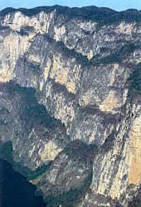
Sumidero Canyon National Park, Mexico. (Photograph by Javier de la Maza Elvira/SEMARNAP)
Introduction
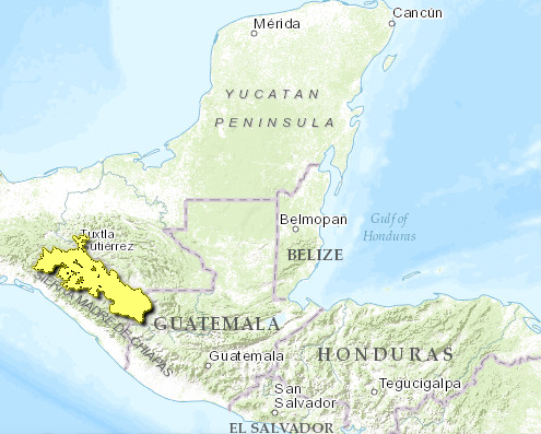
The Chiapas Depression dry forests ecoregion (Chiapas Depression dry forests) is located along the border of Mexico and Guatemala. Biodiversity is high as is endemism. Zapotal-Mactumatza is designated as an Important Bird Area within this ecoregion. The Central Chiapas Depression connects, and is the convergence of two biogeographically important routes: the Gulf and the Pacific; thus, it contains species that have migrated to the dry forest through each of these corridors. Cattle grazing has contributed to the majority of habitat destruction, and continues to threaten the small area of intact forest left.
Location and General Description
 WWF
WWF
The most extensive dry forests in the state of Chiapas, Mexico lies on a vast portion of flat lands called the Central Chiapas Depression. This formation runs east-southwest to west-northwest, with elevations from 420-800 meters (m). It is flanked on the east by very steep slopes running down from the Chiapas plateau, and on the west by the less steep, but highly eroded slopes of the Sierra Madre of Chiapas. The climate is warm and dry, but in higher portions can be warm and sub-humid. Temperature oscillations are not high, and in general the area is mildly humid (less than 1200 millimeters per year (mm/year) precipitation). Rivers on the Central Depression form the system of the Alto Grijalva, which runs in a west-northwest direction. Rivers that run down from the Sierra Madre of Chiapas also feed the Grijalva. Soils are calcareous in nature, rocky and shallow. Plumajillo (Alvaradoa amorphoides) is the dominant tree in the driest of the forest areas, growing mostly on flat lands. Other species include guajpó (Heliocarpus reticulatus), saucillo (Fraxinus purpusii) and copalillo (Bursera bipinnata). The forest becomes taller on slopes at middle elevations, where it has more access to humidity. Cacho de Toro (Bucida macrostachya) is the dominant species, and yoá (Hauya microecerata), copal (Bursera excelsa) and pochota (Ceiba aesculifolia) are common elements associated with it. Herbaceous plants form the lower strata, and some epiphytes grow abundantly on the trees.
Biodiversity Features
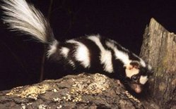 Western spotted skunk (Spilogale putorius), Mexico. (Source: © WWF-Canon/Anthony B. Rath)
 Diverse altitudinal habitat ranges contribute to the existence of a great diversity of communities within the Central Chiapas Depression. The dry forest in this region contains approximately 980 plant species. The degree of endemism is very high, contributing to the estimated 40% of endemic species in dry forest ecosystems of Mexico. The Central Chiapas Depression connects, and is the convergence of two biogeographically important routes: the Gulf and the Pacific; thus, it contains species that have migrated to the dry forest through each of these corridors, which contributes to the diversity (Species diversity) and richness of species in the region. Comisión nacional para el conocimiento y uso de la biodiversidad (CONABIO) has identified a terrestrial priority area within this ecoregion: La Chacona-Cañón del Sumidero. An important bird area has also been identified in this ecoregion: Zapotal-Mactumatza.
Characteristic fauna species include the White-tailed deer (Odocoileus virginianus), mexican west-coast rattlesnake (Crotolus b. basiliscus), horned lizard (Phrynosoma cornutum), lesser-ground cuckoo (Morococcyx erythropygus), and lesser roadrunner (Geococcyx velox).
Current Status
Native dry forests in the Central Depression have been gradually eliminated; few portions of intact vegetation still remain. Challenger estimates that most of the forest has been eliminated and replaced by secondary communities. Federal protection was established a decade ago, but it only covers less than 3% (217 kilometers squared [km2]) of the region.
Types and Severity of Threats
Cattle grazing has contributed largely to the deterioration of this biome, along with intensive logging for agricultural purposes and human settlement.
Justification of Ecoregion Delineation
The delineation for this dry forest ecoregion were derived from current land-cover maps of Mexico, Guatemala, and Rzedowski. Linework follows INEGI by combining "selva baja caudifolia", "selva mediana subcaudifolia", "sabana" and all subsequent human modified [[habitat]s] within the region of the central depression of the Sierra Madre de Chiapas. The ecoregion extends into Guatemala only slightly, and follows the classification of open forest, which was then merged along the borders with the Mexican portion. The delineation’s were then modified by expert opinion during several ecoregion workshops.
References
- Alvarez del Toro, M. 1993. Pages 9-15 in M. Alvarez del Toro, T. G. Cabrera-Cachón, C. A. Guichard-Romero, A. Ramírez-Velázquez, y G. J. Cartas-Heredia, editos, Chiapas y su Biodiversidad. México: Gobierno del Estado de Chiapas.
- Arriaga, L., J. M. Espinoza, C. Aguilar, E. Martínez, L. Gómez, y E. Loa (coordinadores). 2000. Regiones terrestres prioritarias de México. Escala de trabajo 1:1 000 000. Comisión Nacional para el Conocimiento y uso de la Biodiversidad. México.
- Benitez, H., C. Arizmendi, y L. Marquez. 1999. Base de datos de las AICAS. Mexico: CIPAMEX, CONABIO, FMCN, y CCA.
- Challenger, A. 1998. Utilización y conservación de los ecosistemas terrestres de México. Pasado, presente y futuro. México: Conabio, IBUNAM y Agrupación Sierra Madre.
- CONABIO Workshop, 17-16 September, 1996. Informe de Resultados del Taller de Ecoregionalización para la Conservación de México.
- CONABIO Workshop, Mexico, D.F., November 1997. Ecological and Biogeographical Regionalization of Mexico.
- Ferrusquía-Villafranca, I. 1993. Geología de México: Una Sinopsis. Pages 3-108 in T. P. Ramamoorthy, R. Bye, A. Lot, y J. Fa, editors, Diversidad Biológica de México. Orígenes y Distribución. Mexico: Instituto de Biología, UNAM.
- INEGI Map (1996) Comision Nacional Para el Conocimiento y Uso de la Biodiversidad (CONABIO) habitat and land use classification database derived from ground truthed remote sensing data Insitituto Nacional de Estastica, Geografia, e Informática (INEGI). Map at a scale of 1:1,000,000.
- Instituto Geográfico Nacional. 1972. Atlas nacional de Guatemala. Ministerio de Comunicaciones y Obras Pœblicas. Guatemala City, Guatemala.
- Junio, C.A. 1982. Mapa de cobertura y uso actual de la tierra República de Guatemala. Instituto Geográfico Nacional Guatemala, Guatemala City, Guatemala.
- Miranda, F. 1998. La Vegetación de Chiapas. México: Gobierno del Estado de Chiapas.
- Reyes-García, A.J. 1995. Lista de especies y afinidad florística de la selva baja caducifolia de la Depresión de Chiapas. BSc. thesis. Escuela Nacional de Estudios Profesionales Iztacala, UNAM, Mexico.
- Rzedowski, J. 1978. Vegetación de Mexico. Editorial Limusa. Mexico, D.F., Mexico.
- Rzedowski, J. pers. comm. at CONABIO Workshop, 17-16 September, 1996. Informe de Resultados del Taller de Ecoregionalización para la Conservación de México.
- Rzedowsky, J. 1993. Diversidad y orígenes de la flora fanerogámica de México. Pages 129-148 in T. P. Ramamoorthy, R. Bye, A. Lot, y J. Fa, editors, Diversidad Biológica de México. Orígenes y Distribución. Mexico: Instituto de Biología, UNAM.
- SEDUE 1989. Información básica sobre las áreas naturales protegidas de México. Dirección General de Conservación Ecológica de Recursos Naturales. SEDUE, México.
| Disclaimer: This article contains some information that was originally published by the World Wildlife Fund. Topic editors and authors for the Encyclopedia of Earth have edited its content and added new information. The use of information from the World Wildlife Fund should not be construed as support for or endorsement by that organization for any new information added by EoE personnel, or for any editing of the original content. |