Ogilvie-MacKenzie alpine tundra

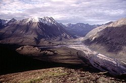
Selwyn Mountains, Yukon-NWT border, Canada Photograph by Lionel Jackson/Used with permission of the Geological Survey of Canada, Natural Resources Canada
This extremely steep, mountainous ecoregion encompasses the Ogilvie and Wernecke mountains, the Backbone Ranges, the Canyon Ranges, the Selwyn mountains, and the eastern and southern Mackenzie Range (these last two are an extension of the Rockies).
Alpine to subalpine northern subarctic Cordilleran describes this region’s ecoclimate. Weather patterns from the Alaskan and Arctic coasts have a significant influence on this ecoregion. Summers are warm to cool, with mean temperatures ranging from 9°C in the north to 9.5°C in the south. Winters are very long and cold, with very short daylight hours. Mean temperatures range from -19.5°C in the south to -21.5°C in the north, where temperatures of -50°C are not uncommon. Mean annual precipitation is highly variable, but generally increases along a gradient from northwest to southeast, with the highest amounts (up to 750 millimeters (mm)) falling at high elevation in the Selwyn Mountains. At lower elevations, anywhere from 300 mm (in the north) to 600 mm (in the south) is the average.
 The bedrock is largely sedimentary in origin, with minor igneous bodies, and much of this is mantled with colluvial debris and frequent bedrock exposures and minor glacial deposits. Barren talus slopes are common. Although parts of the northwest portion of this ecoregion are unglaciated, the majority has been heavily influenced by glaciers. Alpine and valley glaciers are common, especially in the southern and eastern parts of the area where the ecoregion contains broad, northwesterly trending valleys. Valleys tend to be narrower and sharper in the unglaciated northwest. Elevations in the ecoregion also tend to increase as one moves southeast. In the north, in the unglaciated portions of the Ogilvie and Wernecke mountains, elevations are mostly between 900 meters (m) and 1350 m above seal level (asl), with the highest peaks reaching 1800 m. In the central part of the ecoregion, elevations can reach above 2100 m asl, and in the south (Selwyn mountains) peaks reach as high as 2950 m. Permafrost is extensive, and often continuous throughout the region.
Biological Distinctiveness
Subalpine open woodland vegetation is composed of stunted white spruce (Picea glauca), and occasional alpine fir (Abies lasiocarpa) and lodgepole pine (Pinus contorta), in a matrix of willow (Salix spp.), dwarf birch (Betula spp.) and northern Labrador tea (Ledum decumbens). These often occur in discontinuous stands. In the north, paper birch (B. papyrifera) can form extensive communities in lower elevation and mid-slope terrain, but this is less common in the south and east. Alpine tundra at higher elevations consists of lichens, mountain avens (Dryas hookeriana), intermediate to dwarf ericaceous shrubs (Ericaceae), sedge (Carex spp.), and cottongrass (Eriophorum spp.) in wetter sites.
 Snake River, Yukon Territory, Canada. (Source: Photograph by J. Peepre)
 Characteristic wildlife include caribou (Rangifer tarandus), grizzly and black bear (Ursus arctos and U. americanus), Dall’s Sheep (Ovis dalli), moose (Alces alces), beaver (Castor canadensis), red fox (Vulpes vulpes), wolf (Canis lupus), hare (Lepus spp.), common raven (Corvus corax), rock and willow ptarmigan (Lagopus mutus and L. Lagopus), bald eagle (Haliaeetus leucocephalus) and golden eagle (Aquila chrysaetos). Gyrfalcon (Falco rusticolus) and some waterfowl are also to be found in some parts of the Mackenzie mountains.
Outstanding features of this ecoregion include areas that may have remained ice-free during the late Pleistocene–relict species occur as a result. Also, the ecoregion supports a large and intact predator-prey system, one ofthe most intact of the Rocky Mountain ecosystem. The winter range for the Porcupine caribou herd and full season range of the Bonnet-Plume woodland caribou herd (5,000 animals) is found in this area. The Fishing Branch Ecological Reserve has the highest concentration of grizzly bears in North America for this northern latitude.
Conservation Status
Habitat Loss and Degradation
It is estimated that at least 95 percent of the ecoregion is still intact. Mining, mineral, oil and gas exploration are the principal sources of habitat disturbance and loss.
Remaining Blocks of Intact Habitat
The ecoregion is principally intact.
Degree of Fragmentation
To date, the ecoregion has remained principally intact. Roads are increasingly becoming a concern, as is some of the access associated with mineral exploration.
Degree of Protection
- Tombstone Mountain Territorial Park Reserve - Yukon Territory - 800 kilometers squared (km2)
- Fishing Branch Ecological Reserve - northwestern western Yukon Territory - 165.63 km2
Types and Severity of Threats
Most of the threats relate to future access into this northern and fragile ecoregion. Further road development and mineral exploration may result in increased human access. This is already occurring in the western half of the ecoregion.
Suite of Priority Activities to Enhance Biodiversity Conservation
- Enlarge Tombstone Mountain Territorial Park - Yukon Territory
- Establish protected areas in the various mountain ranges that comprise this ecoregion in both Yukon and Northwest Territories.
- Enlarge Fishing Branch Ecological Reserve - Yukon Territory
- Protect the Wind, Snake and Bonnet Plume Rivers.
- Develop protected area proposals for the Keele Peak Area and the Itsi Range - Yukon Territory
Conservation Partners
- Canadian Arctic Resources Committee
- Canadian Nature Federation
- Canadian Parks and Wilderness Society, Yukon Chapter
- Ecology North
- Friends of Yukon Rivers
- World Wildlife Fund Canada
- Yukon Conservation Society
| Disclaimer: This article is taken wholly from, or contains information that was originally published by, the World Wildlife Fund. Topic editors and authors for the Encyclopedia of Earth may have edited its content or added new information. The use of information from the World Wildlife Fund should not be construed as support for or endorsement by that organization for any new information added by EoE personnel, or for any editing of the original content. |