Okanagan dry forests
|
|
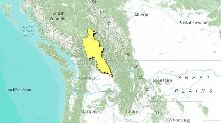
The Okanagan Dry Forests ecoregion occupies the southern interior of British Columbia and adjacent Washington state between the Rocky Mountains to the east and the coastal ranges to the west.
Mean annual temperature is around 7°C, mean summer temperature ranges from 15°C to 16.5°C, and mean winter temperature is around -2.5°C. A strong elevational gradient in precipitation occurs, ranging from 250 millimeters (mm) to over 1000 mm per year. On average, precipitation is in the range of 400 mm on the plateaus. This ecoregion is characterized by very warm to hot, dry summers and moderately cool winters with little snowfall.
This ecoregion is composed of flat-lying Tertiary sediments and volcanic rocks 1220-1525 meters (m) above sea level in elevation. Its gently rolling surface is incised by many rivers below the general surface.
Contents
Biological Distinctiveness
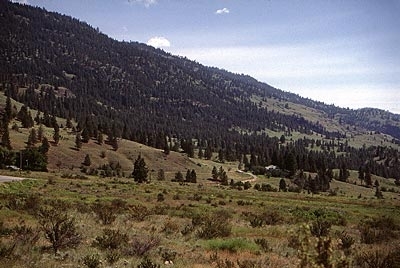
Vegetative cover is quite diverse in this region. It encompasses alpine, forests, and grasslands. Forest cover ranges from lodgepole pine (Pinus contorta) with quaking aspen (Populus tremuloides), white spruce (Picea glauca), and Douglas-fir (Pseudotsuga menziesii) on the plateau to Douglas-fir and pine grass at moderate mid-slope elevations. In subalpine areas, Engelmann spruce (P. engelmannii), subalpine fir (Abies lasiocarpa), and lodgepole pine grow. Valley bottoms contain ponderosa pine (P. ponderosa) with bluebunch wheatgrass (Agropyron spp.), blue grass, June-grass (Koelaria spp.) and sagebrush (Artemisia tridentata).
Characteristic wildlife of this ecoregion includes black bear (Ursus americanus), Northern river otter (Lontra canadensis), bighorn sheep (Ovis canadensis), black and white-tailed deer (Odocoileus hemionus and O. virginianus), coyote (Canis latrans), bobcat (Lynx rufus), cougar (Puma concolor), American badger (Taxidea taxus), California quail (Callipepla californica), waterfowl, blue grouse (Dendragapus obscurus) and long-billed curlew (Numenius americanus).
This ecoregion contains the northern continental range extensions of many species of reptiles, amphibians, insects and plants.
Conservation Status
Habitat Loss
It is estimated that only about 20 percent of this ecoregion remains as intact habitat. Some parts of the ecoregion have been heavily altered due to growing urban expansion and conversion of land into agricultural production. This is particularly true of the valleys and basins. Upper elevations have been impacted by livestock grazing, logging, open pit mines, agriculture, and transmission and pipeline corridors. Some grasslands have been seriously over-grazed by livestock.
Remaining Blocks of Intact Habitat
There are few remaining unprotected blocks of habitat remaining in this ecoregion.
Degree of Fragmentation
Connectivity of grassland [[habitat]s] for reptiles and amphibians is highly impaired in the major valleys. The connectivity of forest species is intermediate in most forest habitats, except for the major travel corridors across the Thompson Plateau where there are median dividers and 2-3 meter-high fences for great lengths.
Degree of Protection
- Dunn Peak Provincial Park - southern British Columbia - 198.19 square-kilometers (km2)
- Lac Du Bois Provincial Park - southern British Columbia - 145.44 km2
- Bonaparte Provincial Park - southern British Columbia - 118.06 km2
- Okanagan Mountain Provincial Park - southern British Columbia - 106.5 km2
- Arrowstone Provincial Park - southern British Columbia - 104.44 km2
- Silver Star Provincial Park - southern British Columbia - 87.14 km2
- Guichon Provincial Park - southern British Columbia - 51.19 km2
- Toweel Provincial Park - southern British Columbia - 46 km2
- Roche Lake Provincial Park - southern British Columbia - 21.32 km2
- Porcupine Provincial Park - southern British Columbia - 19.88 km2
Types and Severity of Threats
Many of the valley bottoms, including bunchgrass and bunchgrass/sagebrush, are under intensive pressure from agriculture and urban development. Most of the remaining patches are slated for conversion. Upland forest [[habitat]s] have either been logged in the past or are all slated for logging in the future. Many of these areas lie on public lands and will remain under forest cover, although forest communities may be significantly altered or degraded.
Suite of Priority Activities to Enhance Biodiversity Conservation
- Long-term restoration and an increase in protection for the grassland habitats.
- Private stewardship and nature trust activities are critical for the conservation of biodiversity in this ecoregion.
Conservation Partners
- Canadian Parks and Wilderness Society, British Columbia Chapter
- Friends of Okanagan Mountain Park
- Kamloops Naturalists
- The Nature Conservancy, British Columbia
- Nature Trust of BC
- North Okanagan Naturalists Club
- Northwest Wildlife Preservation Society
- Okanagan Silkameen Parks Society
- World Wildlife Fund Canada
Relationship to other classification schemes
The Thompson-Okanagan Plateau (TEC 209) comprises most of the area of the Okanagan dry forests, and the Okanagan Highland (TEC 211) in the south is also included in the Canadian portion of the ecoregion. In terms of forest regions, this ecoregion incorporates the Strait of Georgia Coast forest (1), Grassland, Interior Subalpine (2) and Montane forests of Ponderosa Pine and Douglas-fir (1) and Central Douglas-fir (2).
| Disclaimer: This article contains certain information that was originally published by the World Wildlife Fund. Topic editors and authors for the Encyclopedia of Earth have edited its content and added new information. The use of information from the World Wildlife Fund should not be construed as support for or endorsement by that organization for any new information added by EoE personnel, or for any editing of the original content. |

