Northern mixed grasslands
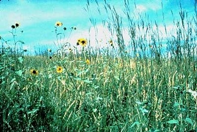
Karl Mundt NWR, South Dakota, USA Photograph by G.R. Zahm/ USFWS
|
|
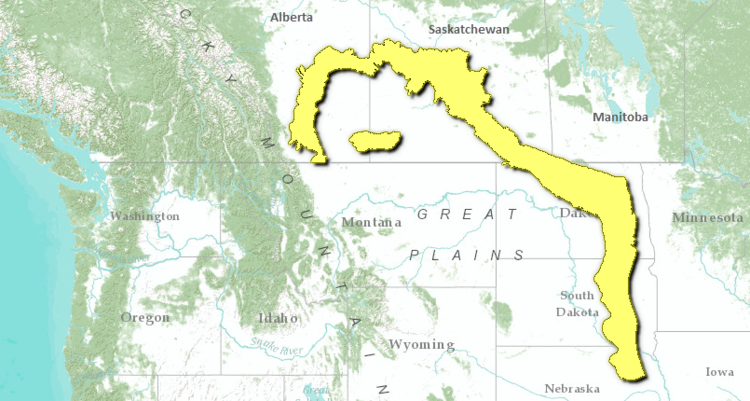
The Northern Mixed Grasslands cross Alberta, Saskatchewan, and southern Manitoba in Canada, and run from North Dakota to northern Nebraska in the U.S., covering about 270,000 km2.
Essentially an ecotone, this transitional belt ecoregion separates the three tall grass prairie ecoregions to the east (Northern, Central, and Flint Hills Tall Grasslands) from the Northwestern Mixed Grasslands. In addition, the ecoregion separates the shortgrass prairie to the south from the cooler boreal forests to the north. This ecoregion is intermediate in growing season length, vegetation structure, and rainfall from the drier units to the west and the more mesic tall grass prairies to the east. It is separated from the Central and Southern Mixed Grasslands by climatic factors, the southern unit having a much warmer climate and a longer growing season. In the Canadian portion of this ecoregion, the mean annual temperature is approximately 3°C, mean summer temperature is 15.5°C, and the mean winter temperature is -10°C. This ecoregion is considered to be a transitional grassland ecoclimate with semiarid moisture conditions. Mean annual precipitation ranges from 325-450 milimeters (mm).
 World Wildlife Fund
This ecoregion is arguably the most disturbed among North American grassland ecoregions with only a few remnant patches remaining, none of which are considered to be fully intact. Conversion to agriculture has completely changed the landscape in an ecoregion that once supported large populations of bison (Bison bison). Restoration of representative examples of this ecoregion will be a major challenge.
Contents
Biological Distinctiveness
The Mixed Grass prairie was recognized by Clements as a mixture of the tallgrass and shortgrass prairies. The dominant grasses found here include grama (Bouteloua gracilis), little bluestem (Schizachrium scoparium), needle-and-thread grass (Stipa comata), wheatgrass (Agropyron smithii), Carex filifolia, junegrass (Koelaria cristata), and Poa secunda. Kuchler classified the dominant vegetation as wheatgrass-bluestem-needlegrass. Essentially, the floristic composition of this unit has been determined largely by drought and grazing pressure, with fire having a less prominent role than in the tallgrass prairie ecoregions.
Further north in the ecoregion, the transitional grassland ecoclimate supports a vegetation of quaking aspen (Populus tremuloides), bur oak (Quercus macrocarpa) groves, mixed tall shrubs, and intermittent fescue grasslands. Generally, quaking aspen and shrubs occur on moist sites while bur oak and grass species occur on increasingly drier sites. The southeast portion of the ecoregion tends to be warmer and drier. Remaining native vegetation in this portion of the ecoregion is dominated by spear grass and wheat grass. In addition, local saline deposits support alkali grass, wild barley, red sampire, and sea blite. In the separated Cypress Upland, fescue and wheatgrass grow below 1000 meters (m), and mixed montane forests of lodgepole pine, deciduous trees and shrubs grow at higher elevations. Larkspur (Delphinium sp.), death camas (Zigadenus elegans), and wild lupine (Lupinus sp.) are found here and nowhere else in the prairies.
The topography is broken by many glacial pothole lakes, making this ecoregion the most productive breeding area for waterfowl in the USA. Other wildlife characteristic of the moist mixed grassland are black-tailed and white-tailed deer (Odocoileus hemionus and O. virginianus), pronghorn antelope (Antilocapra americana), coyote (Canis latrans), short-horned lizard (Phrynosoma douglassi), western rattlesnake (Crotalus viridis), rabbit (Sylvilagus sp.) and sage grouse (Centrocercus urophasianus). Yellow-rumped warbler (Dendroica coronata) is also found only in this part of the prairies. Bison were once a common feature of this ecoregion. Grazing by ungulates, fire, and drought were major sources of disturbance.
The ecoregion provides continentally significant waterfowl production and is a major staging area. It is estimated that up to 80 percent of the wetlands, however, have been lost or degraded. The Cypress Uplands (Alberta/Saskatchewan), which are believed to have escaped the last glaciation, are located in this ecoregion. A large number of disjunct species populations of both flora and fauna are found here.
Conservation Status
Habitat Loss
Virtually no major areas of intact habitat remain within this ecoregion. It is estimated that more than seventy five percent of the ecoregion has been heavily altered. Agricultural conversion of natural prairie is the prime reason for the high rate of habitat loss. Most of the less altered patches of habitat, however, contain representatives of the native flora.
Remaining Blocks of Intact Habitat
No completely intact blocks of habitat remain. Restoration of some areas is just beginning. The following sites may be characterised more as large fragments or clusters of fragmented habitat.
- Turtle Mountain - southern Manitoba - on the border of the ecoregion
- Prairie Coteau - northeastern South Dakota- only part, also included in the central tall grasslands
- Last Mountain Lake - southern Saskatchewan - an important prairie restoration site and a huge migratory bird stopover area
- Missouri WSR - 324 km2 of habitat (unprotected)
- J. Clark Salyer National Wildlife Refuge - north central North Dakota - 269 km2
- Pembina Gorge - northeastern North Dakota
- Prairie Coteau
- Sheyenne Delta
- Cypress Hills/Uplands - Alberta and Saskatchewan
- Dundurn Military Reserve - Saskatchewan
Degree of Fragmentation
As stated above, the small patches of altered habitat worthy of conservation consideration within the Northern Mixed Grasslands are essentially isolated and highly fragmented.
Degree of Protection
Few sites are presently protected within this ecoregion. These include:
- Rumsey Ecological Refuge - Alberta
- Hand Hills Ecological Refuge - Alberta
- Lost Mountain Lake
- Cypress Hills Provincial Park - Saskatchewan - 183.51 km2
- Rumsey South - Alberta - 125 km2
- Douglas Provincial Park - 61.44 km2
- Hand Hills Ecological Reserve - Alberta - 22.29 km2
- Danielson Provincial Park - Saskatchewan - 21.53 km2
- Blackstrap Provincial Park - Saskatchewan -5.26 km2
- Pike Lake Provincial Park - Saskatchewan - 5 km2
Types and Severity of Threats
Virtually all of the ecoregion has already been converted by human use and heavily altered. Introduction of prairie flora exotics and intensification of habitat conversion (including altered habitat to more heavily altered habitat) for agricultural purposes are ongoing major threats. Disturbance to major waterfowl populations is a concern.
Suite of Priority Activities to Enhance Biodiversity Conservation
- Restoration: there is a need to identify as many remnant habitat patches as possible and to review their status to determine priority areas for restoration. Opportunities include the Prairie Coteau area, further work on Last Mountain Lake (Sask.), a review of Wildlife Habitat Protection lands, as well as lands held by Ducks Unlimited.
- The following steps are recommended to restore representative examples of this ecoregion:
- systematically identify remnant pieces of habitat that are in near pristine condition
- protect and restore these areas to prevent critical loss of this ecosystem
- design an ecoregion strategy based upon bringing back small pieces of this unit
Conservation Partners
- Alberta Wilderness Association
- Canadian Parks and Wilderness Society, Calgary/Banff Chapter
- Critical Wildlife Habitat Program
- Ducks Unlimited Canada
- Endangered Spaces Campaign - Manitoba
- Endangered Spaces Campaign - Saskatchewan
- Federation of Alberta Naturalists
- Manitoba Heritage Habitat Corporation
- Manitoba Naturalists Society
- Meewasin Valley Authority
- The Nature Conservancy of Nebraska
- The Nature Conservancy, Alberta
- The Nature Conservancy, British Columbia
- The Nature Conservancy, Tallgrass Prairie Office
- Nature Saskatchewan
- Prairie Conservation Forum
- Resource Conservation Manitoba
- Society of Grassland Naturalists
- US Fish and Wildlife Service
- World Wildlife Fund Canada
Relationship to other classification schemes
The boundary for the Northern Mixed Grasslands is derived from Sims. It corresponds to Omernik ecoregion 46 (Northern Glaciated plains) in the U.S., and Küchler unit no.60 (wheatgrass, bluestem, needlegrass). The comparable Bailey sections south of the Canada-U.S. border are: 332A (Northeast Glaciated Plains) 332B (Western Glaciated Plains), 251B (North Central Glaciated Plains-extreme Western part).
In Canada, most of this ecoregion is Moist Mixed Grassland, surrounding Fescue Grassland. Separated from the larger portion of the ecoregion is the Cypress Upland (TEC 160), which is an outlier of the montane vegetative zone that occurs on the lower slopes of the Rocky Mountains. This ecoregion includes both Grassland and Boreal forest regions, specifically Aspen-Oak, Aspen Grove and Northern Foothills Boreal forest sections (16, 17 and 19a) (Rowe 1972).
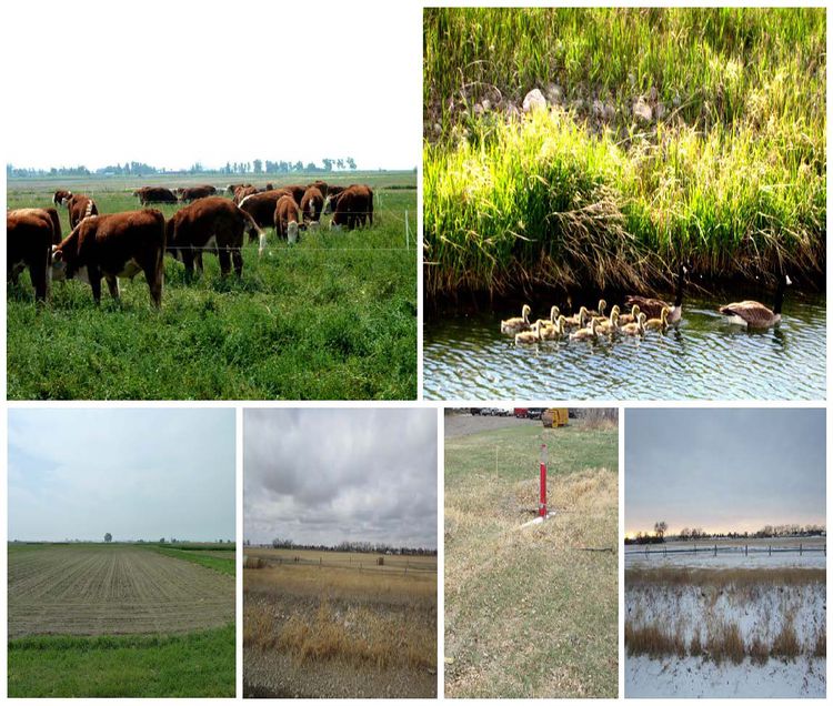 Glimpses of Northern Mixed Grassland Prairies, Alberta, Canada. Source: Saikat Basu, own work.
| Disclaimer: This article contains information that was originally published by the World Wildlife Fund. Topic editors and authors for the Encyclopedia of Earth have edited its content and added new information. The use of information from the World Wildlife Fund should not be construed as support for or endorsement by that organization for any new information added by EoE personnel, or for any editing of the original content. |