Alaska-St. Elias Range tundra
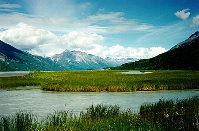
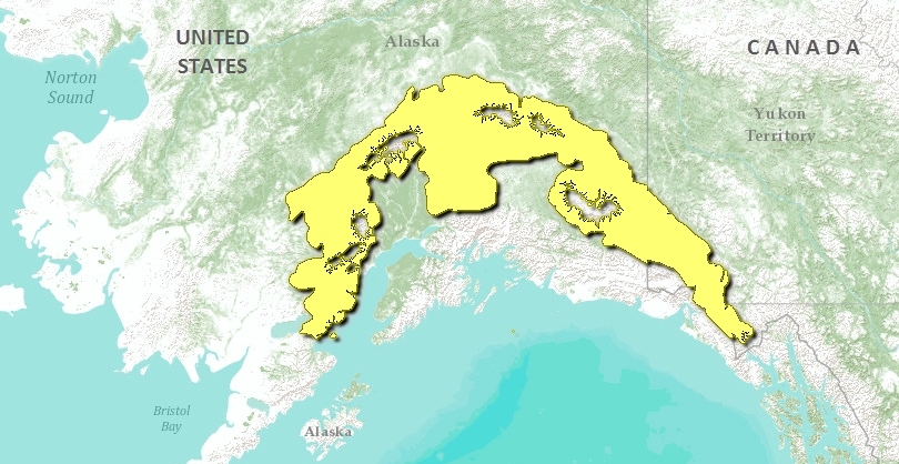
The Alaska/St. Elias Range Tundra is a long belt of high, rugged mountains arcing north from the base of the Alaska Penninsula, east to encompass the Alaska Range, and south to include the Wrangell/St. Elias Range on the Canadian/Alaskan border near Yakutat Bay. The Canadian portion of this ecoregion encompasses the southwestern corner of the Yukon Territory and extreme northwestern British Columbia.
Elevations range from sea level at the western end, to 600 meters (m) in the broad, lower valleys, often to over 4,000 meters. Mt. McKinley, the highest point in North America, lies within the ecoregion, with an elevation of over 6,100 meters. The St. Elias Mountains are among the highest in Canada, ranging upward to 6000 meters above sea level (masl). Peaks stand as isolated blocks separated by broad ice fields. Because the limit of permanent snow is 2150 masl, the mountains present great masses of ice and snow, causing great valley glaciers. Permafrost is continuous at high elevation and sporadic and discontinuous at low elevation.
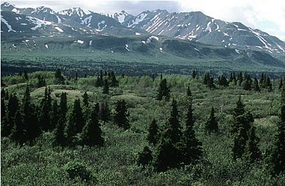
The ecoregion, which covers 169,091 kilometers squared (km2), consists mostly of rocky slopes, icefields, and glaciers. Where permanent ice and snow fields do not dominate, alpine tundra vegetation is usually dominated by dwarf shrub communities, including mountain-avens (Dryas octopetala, D. integrifolia) and ericaceous species (e.g. Vaccinium vitis-idaea, Cassiope tetragona). More protected slopes support low or tall scrub communities, consisting of dwarf birch (Betula glandulosa and B. nana), willows (Salix spp.), alder (Alnus sinuata and A. crispa) and ericaceous shrubs. Well-drained sites in the lower valleys can support open forests of white and black spruce (Picea glauca, P. mariana), or paper birch (Betula papyrifera) and quaking aspen (Populus tremuloides). Wet sites in this area support cottongrass and sedge.
Location and General Description
For much of its distance, this ecoregion is inland of another mountain belt, the Pacific Coastal Mountain Icefields and Tundra, resulting in a dominance of continental climate influences. Annual precipitation averages about 400 millimeters (mm) in the lower elevations and estimated to average over 2,000 mm in the higher elevations. Daily temperature minimum averages in the winter range from -25°C to -34°C, while average daily maximum temperatures in the summer range from 18°C to 22°C. Temperatures are lower throughout the year at higher elevations. Further south in the Canadian portion of the ecoregion, annual temperature decreases with elevation, but at valley bottoms it is -1.5°C, with a summer mean of 9.5°C, and a winter mean of -14°C. Mean annual precipitation increases with elevation, ranging from approximately 300 mm at low elevations, to more than 1000 mm in the ice fields. Generally, this ecoregion has an alpine and glacierized North Pacific Cordilleran ecoclimate.
This region is characterized by permanent ice and snow fields, and minor areas of rock outcrop, rubbly colluvium, and alpine tundra vegetation. Glaciation was extensive during the Pleistocene, and much of the ecoregion's area remains under permanent ice. Soils are quite poor, shallow over bedrock, and generally do not retain enough moisture to form permafrost.
Biological Distinctiveness
The Alaska/St. Elias Range Tundra ecoregion is an almost entirely intact ecological system, with its full complement of top level predators within their natural range of variation. There are significant brown bear concentrations in Denali Park, Prairie Creek, and in coastal portions in the southwest part of the ecoregion, near Lake Iliamna and Kamishak Bay. Other wildlife includes mountain goat (Oreamnos americanus), caribou (Rangifer tarandus), moose (Alces alces), Dall’s sheep (Ovis dalli), beaver (Castor canadensis), Snowshoe hare ( Lepus americanus), salmon, and other fish.
Conservation Status
 This ecoregion has suffered very little habitat loss, degradation, or fragmentation. Minor losses are associated with development at the entrance to Denali National Park, at the north side of Denali Park at Kantishna, surrounding the abandoned Kennicott copper mine in the Wrangell Mountains, and at Nabesna in the Wrangells. Also, coal mining at Healy (northeast of Denali Park) has caused some habitat loss. Several roads cross the ecoregion, but their fragmentation effect is relatively low, and habitat blocks between them are all larger than 10,000 km2. Human habitation is low, and human use is generally limited to recreation, subsistence, and sport hunting and fishing. Wildfire occurrence is low, with most of the fires occurring in the central part of the ecoregion, and ranging in size from 0.01 km2 to 32.9 km2.
Degree of Protection
Important protected areas include:
- Lake Clark National Park and Preserve - southern Alaska
- Denali National Park - south central Alaska
- Denali State Park - south central Alaska
- Tetlin National Wildlife Refuge - southeastern Alaska
- Wrangell-St. Elias Park and Preserve - Alaska
- Tatshenshini Park - northwestern British Columbia (partially in the ecogregion) - 9,580 km2
- Kluane National Park - southwestern Yukon Territory - 22,015 km2
- Kluane Game Sanctuary - low level protection - southwestern Yukon Territory
Types and Severity of Threats
No severe threats currently face this ecoregion on a large-scale. Some smaller-scale threats include:
- Excessive recreational use surrounding national parks and wildlife areas. Impacts could become acute locally.
- Over-harvest of wildlife is possible, although currently populations are well managed.
- Expanded mineral exploration and exploitation. This region contains many extractable mineral resources, including gold, silver, lead, copper, coal, uranium, and molybdenum. The world's richest copper deposits were mined at Kennicott in the southern Wrangell Mountains in the early part of the century.
Suite of Priority Activities to Enhance Biodiversity Conservation
- Management of recreation, tourism, and related facilities in Denali and Wrangell-St. Elias Parks to minimize impact and avoid excessive use of local areas.
- Protection of bear populations at Prairie Creek and near Kamishak Bay. Currently these areas have no formal protection designation. Any protection must happen through cooperative approaches with the Native corporations who own title to the lands in these areas.
- Work with Native corporations who own land within U.S. national parks (especially inholdings in Lake Clark and Wrangell-St. Elias Parks) to ensure compatible land uses.
Conservation Partners
- Canadian Arctic Resources Committee
- Canadian Parks and Wilderness Association, Yukon Chapter
- Friends of Yukon Rivers
- National Parks and Conservation Association
- The Nature Conservancy - Alaska (regarding Prairie Creek)
- The Sierra Club
- The Wilderness Society
- World Wildlife Fund Canada
- Yukon Conservation Society
| Disclaimer: This article is taken wholly from, or contains information that was originally published by, the World Wildlife Fund. Topic editors and authors for the Encyclopedia of Earth may have edited its content or added new information. The use of information from the World Wildlife Fund should not be construed as support for or endorsement by that organization for any new information added by EoE personnel, or for any editing of the original content. |


