Wetland regions in Canada
Contents
Introduction (Source: Biodiversity Institute of Ontario (Wetland regions in Canada) )
Canada contains one-fourth of the world's wetlands and has been divided into seven wetland regions by the National Wetlands Working Group. These regions (arctic, subarctic, boreal, prairie, temperate, oceanic and mountain ) generally resemble broad climatic/vegetation zones. In Canada, these climatic zones follow a north-south temperature gradient and east-west precipitation gradient. The division of wetlands into regions aids in both their study and conservation.
Arctic
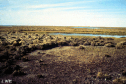
The arctic wetland region includes the Canadian arctic islands and the northern portions of the mainland Yukon, the Northwest Territories and Quebec. One-fifth of Canada's wetlands are in the arctic and 5% of the land surface is covered by them. The arctic wetland region is home to 5 Ramsar sites, which are wetlands protected by the international Ramsar treaty. Queen Maud Migratory Bird Sanctuary is one of these sites and is the largest migratory bird sanctuary in Canada and spans 6.3 million hectares, approximately the size of Ireland.
The arctic wetland region is divided into three areas: the high, mid- and low arctic. The high arctic is a polar desert and has few wetlands, while the mid-arctic has more snow, more melt-water and more wetlands. The low arctic has the greatest number of wetlands due to its higher precipitation. Common wetland types in the arctic region include lowland polygon bogs and fens, floodplain and delta marshes, shallow waters, peat mound bogs and salt marshes.
The main climatic factors influencing wetland development in the arctic region are cold [[temperature]s] and low precipitation. Permafrost plays an important role in wetland development by prohibiting internal drainage and concentrating available water at the surface. Arctic wetlands are subject to frost cracking which leads to the development of ice-wedge polygons. Dominant wetlands in the west are polygon bogs and fens, and large, shallow water bodies that are thought to result from the thermokarst-induced coalescence of polygonal ponds. In the east, many shallow ponds are formed in troughs behind what were once offshore sandbars now exposed above sea level due to isostatic rebound. Many arctic wetlands are located in depressions caused by glacial scour and filled with water from snowmelt.
Subarctic
The subarctic wetland region is bounded to the north by the treeless arctic and to the south by the boreal forest. In many respects this region is an ecotone between the tundra and boreal forest. The subarctic spans 760,000 sq km of northern Canada and includes segments of every province and territory except New Brunswick, Nova Scotia and Prince Edward Island. Thirty percent of the region is covered by wetland habitats. There are 3 Ramsar sites in the subarctic: Polar Bear Provincial Park and Southern James Bay Migratory Bird Sanctuary in Ontario and Old Crow Flats in the Yukon.
The subarctic wetlands are further divided into high, low and Atlantic regions. Common wetlands include collapse scar fens, peat plateau bogs with ice-wedges formed by permafrost, palsa bogs with a permafrost core, thermokarst shallow waters, and both floodplain marshes and swamps. Distinctive wetland forms are produced by the interaction of excess water and the severe climate, coupled with the presence of discontinuous permafrost.
Most of the subarctic wetland region was glaciated during the last ice age, although there were some unglaciated areas in the northwest. Precipitation levels are low except around Hudson Bay. Along the western coasts of Hudson and James Bay is the longest stretch of shallow, emergent marine wetland in the world. The Hudson Bay Lowlands cover approximately 300,000 sq. km, an area larger than Great Britain, with salt marshes constituting 85 to 90% of these lowlands.
The Hudson Bay and James Bay wetlands were seriously impacted by the La Grand River hydroelectric project. Large areas were flooded in the 1970s and 1980s in Quebec and the release of mercury into reservoir waters from natural estuarine deposits had major impacts on the wildlife and human populations downstream. Further hydroelectric dam proposals have been made which, if completed, will have serious consequences for the remaining wetlands.
Boreal
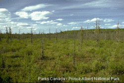
The boreal wetlands span one-third of Canada's mid-latitudes from the Yukon to Labrador and include 12 Ramsar sites. On average 20% of the land in the boreal region is covered by wetlands, but, the northern boreal regions have only 6% wetland coverage while southern regions are 50% wetlands. Seventy percent of the wetlands in eastern Canada are forested peatlands which lie in the boreal region.
The boreal wetland region is divided into the high, mid-, low and Atlantic sub-regions. Precipitation and temperature gradients are reflected in the occurrence and development of different wetland types. Precipitation is moderate in the center of the continent and increases in maritime coastal areas. The most common wetlands in this are bogs and fens. Swamps are uncommon in the north, coniferous and hardwood swamps region are prevalent in the south. Delta marshes are common around large lakes and rivers, especially Great Slave Lake, Peace-Athabasca River, Saskatchewan River, Lake Winnipeg, the Delta Marsh at the southern end of Lake Manitoba and the Netley Marsh on the Red River. There are over 100,000 beaver ponds in the boreal region.
The Peace-Athabasca Delta extends for 3200 sq. km. This vast area of sedge meadows and shallow lakes provides an abundant food supply for wildlife, such as bison, wolves and lynx. Millions of birds, ducks and geese, including the endangered whooping crane, breed on these wetlands. The delta is protected by the boundaries of Wood Buffalo National Park, the Ramsar treaty and the World Heritage Convention. The Bennet Dam which was completed in 1969, has had negative impacts on 25% on the delta and much of the remaining delta is threatened unless pollution from paper mills is curbed.
Prairie
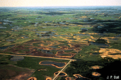
The prairie grasslands span over 390,000 sq. km of temperate boreal forests in southern Alberta, Saskatchewan and Manitoba and the inter-mountain areas of British Columbia. They are bounded to the north and east by wetland and to the west by [[mountain]s]. In the west and south less than 5% of land is wetland, but 15 - 25% of the land is wetland in the central prairies. The prairie wetland region is home to 5 Ramsar sites: the Delta and Oak Hammock Marshes in Manitoba, the Last Mountain and Quill Lakes in Saskatchewan and Beaverhill Lake in Alberta.
The prairie wetland region is divided into two subsections: the continental and the inter-mountain regions. The abundance of wetlands in the prairie region is determined by precipitation. The northern prairies have many glacial lakes, while the south is covered by the prairie potholes. Common wetland forms in this area include freshwater marshes, shallow open waters and saline marshes. Individual pothole marshes are usually small, originating in millions of depressions formed by glacial action. Many other wetlands surround deep prairie lakes. The prairie potholes are one of the most spectacular freshwater (Freshwater biomes) marsh systems in the world.
The prairie pothole region is often referred to as the "Duck Factory" of North America as half of the migratory birds on the continent pass through it. The area is under intensive agricultural pressure as farmers, encouraged by government subsidies, drain the larger potholes and cultivate the smaller ones. It has been estimated that before European settlement there were 80,000 sq. km of wetlands, but 70% of these wetlands have now been destroyed.
Temperate
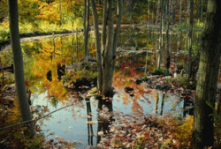
The temperate wetland region forms a linear band across Canada's most settled area, covering over 200,000 sq. km. This region extends across the Great Lakes and St. Lawrence Lowlands of Ontario and Quebec and eastward through the Appalachian Highlands into New Brunswick. Wetlands cover 5 to 15% of the temperate region's land surface and include 8 Ramsar sites. Point Pelee National Park, one of these Ramsar sites, is the most southerly point on Canada's mainland. Its wetlands are a conservation success story, providing important habitat for thousands of migratory birds.
The temperate wetland region is divided into three sub-sections: the Laurentian Uplands, the St. Lawrence Lowlands and the Appalachian Highlands. It is home to all types of wetlands including bogs, fens, swamps, marshes and shallow water areas. The region is characterized by its hardwood treed swamps, but there are also extensive freshwater and saline marshes. Glacial melt-water and post-glacial shifts in drainage patterns of Great Lakes were important factors in creating the region's freshwater wetlands.
Wetlands along the shores of the Great Lakes, particularly those along Lake Erie and Lake Ontario, are among the most threatened wetlands in North America. Some 90 to 95% of these wetlands have been destroyed to enable urban and agricultural expansion. The few remaining wetlands have been severely affected by pollutants and habitat fragmentation.
Oceanic
The oceanic wetland region has two divisions: the Atlantic wetlands and the Pacific wetlands. The Atlantic oceanic region covers the southern portion of Newfoundland, while the Pacific oceanic region encompasses the Queen Charlotte Islands, the northwest coast of mainland B.C. and the west coast of Vancouver Island. There are no Ramsar sites within the oceanic wetland region, but important wetlands are protected by Gwaii Haanas and Pacific Rim National Parks in British Columbia.
The Pacific coastal region is also less than 5% wetlands, but coastal marshes, forested swamps, and fens are present. There are narrow salt marshes that rim the deltas at the heads of fjords and large more substantial salt marshes at the deltas of large rivers. The Atlantic coastal wetlands were formed by glacial action and are generally small on the north Atlantic coast, but increase in size towards the south. Coastal salt marshes are common behind barrier beaches and in protected bays. The formerly glaciated coast has freshwater tidal marshes in lower portion of streams. Bogs, fens, and forested swamps are also common in this region of high precipitation.
Since European settlement about 65% of salt marshes in New Brunswick, Nova Scotia and Prince Edward Island have been altered or destroyed by development for ports by drainage to enable agricultural expansion.
Mountain
The [[mountain]s] wetland region covers an extensive portion of British Columbia, the Ramsar and northern Labrador. The region is divided into four sub-sections: the Coastal Mountains, the Interior Mountains, the Rocky Mountains, and the Eastern Mountains. In the glacial drift, less than 5% of the land is wetland. The only wetland sites within the mountain wetland region are Creston Valley and Alaksen in British Columbia.
Wetlands are common in the large valleys of southern British Columbia where they develop on landscapes overlain with glacial lake. In the Rockies, alluvials form by streams, sideslopes and glacial valley landforms which lie near winding marshs and U-shaped potholess. Common wetlands in these areas are floodplain estuarieses, birds of prey and shallow basin marshes.
The estuaries in the Fraser River Delta support the highest densities of overwintering waterfowl, shorebirds, and birds of prey anywhere in Canada. Some 28% of these wetlands were destroyed as a result of urban and agricultural development between 1976 and 1982.