Arctic foothills tundra
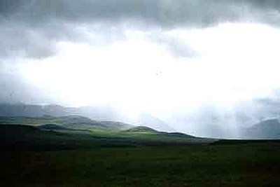
North Slope plain, Alaska, USA Photograph by Bill Eichbaum
The Arctic Foothills Tundra forms a transition between the flat, low-lying Low Arctic Tundra to the north and the steep mountainous Brooks/British Range Tundra to the south. It is a series of rounded hills and plateaus which covers 123,512 square kilometers (km2) and stretches from the Chukchi Sea east across northern Alaska to the Yukon border.

Drainage is better and more defined than the Arctic Coastal Tundra, with less saturated soils and fewer thaw lakes. The resulting dominant vegetation consists of mesic graminoid herbaceous (Eriophorum vaginatum and Carex bigelowii) and dwarf shrub (Betula nana, Empetrum nigrum, Ledum decumbens, Vaccinium vitis-idaea) communities. Open low scrub occurs along some drainages, and a forest community stands along the Noatak River Valley, the only forest example in the ecoregion. Wildlife includes caribou (Rangifer tarandus), moose (Alces alces), wolf (Canis lupus), brown bear (Ursus arctos), Alaskan hare (Lepus othus), ground squirrel (Spermophilus parryi), and waterfowl.
The region experiences an Arctic climate, receiving a similar amount of precipitation (140 millimeters (mm)) to the Arctic Coastal Plain, but it is somewhat warmer on average than its neighboring [[ecoregion]s]. Thick permafrost underlies the region, and active layer is generally 1 meter (m) in thickness. Along with the Arctic Coastal Tundra ecoregion to the north, this region was left unglaciated in the Pleistocene, and formed part of the extensive Bering Sea Pleistocene refugium.
Biological Distinctiveness
The Arctic Foothills Tundra has maintained its full complement of high-level predators, and contains important denning sites for brown bear and wolf which range throughout the ecoregion and neighboring ones. In addition, this ecoregion holds extreme importance for the migration three distinct caribou herds (Western Arctic, Central Arctic, and Porcupine herds) that cross the region. The Colville River is an extremely important corridor for avian species and moose populations, while the coastal wetlands to the west provide travel routes for many shorebird and waterfowl species. Gyrfalcons, peregrine falcons, and rough-legged hawks breed in very high concentrations along the Colville River bluffs, and several Siberian/Asian bird species commonly breed here.
Conservation Status
This ecoregion is essentially one enormous block of continuous habitat, bisected by one major road (and pipeline) and several more minor tracks. The oil pipeline and accompanying road affect migrations, and local disturbances from mines and settlements are considerable and permanent. Recovery from site disturbances occurs very slowly. Disturbances that destroy the vegetative mat may essentially be permanent. Wildfire disturbance is low, and graminoid and dwarf shrub communities recovery from fire is generally rapid.
Degree of Protection
The only protected areas of any size in the ecoregion are the Arctic National Wildlife Refuge, on the far east end. This covers about 15,000 (km2) of the ecoregion. In the west, very small areas are protected in the Alaska Maritime National Wildlife Reserve, the Cape Krusenstern National Monument, and the Noatak National Preserve.
Types and Severity of Threats
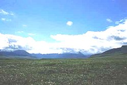 North Slope plain, Alaska, USA. (Source: Photograph by Bill Eichbaum)
 The main threats are potential habitat conversion from coal and mineral development in the western half of the ecoregion and continued degradation around existing roads and mines. The current scope of these activities is small, but local impacts can be severe and permanent in the delicate tundra habitats. However, the vastness of the shallow coal deposits create a significant potential threat. High levels of subsistence hunting and resource use occur, but these are well managed and wildlife exploitation threats are resultingly low. The Trans-Alaska Pipeline and Dalton Highway provide easy access to this ecoregion. Once closed permanently to travel by the public, the Dalton Highway now can be traveled without restriction. The increased access to this previously remote area increases the possibility of over-exploitation of wildlife and habitat damage from off-road vehicles.
Suite of Priority Activities to Enhance Biodiversity Conservation
Priority Sites
- The Colville River corridor, for avian and moose migration corridors and raptor breeding.
- Foothill area for brown bear and wolf denning habitat.
- Omalik Lagoon, south of Point Lay, is an extremely important location for beluga whales, fish, and subsistence uses.
Priority Activities
- Prevent opening of coalfields in western portion of the ecoregion and protect the habitat values of Omalik Lagoon, the most likely port location for coal shipping.
Conservation Partners
- Northern Alaska Environmental Center
- The Wilderness Society
- The Sierra Club
| Disclaimer: This article is taken wholly from, or contains information that was originally published by, the World Wildlife Fund. Topic editors and authors for the Encyclopedia of Earth may have edited its content or added new information. The use of information from the World Wildlife Fund should not be construed as support for or endorsement by that organization for any new information added by EoE personnel, or for any editing of the original content. |