High Arctic tundra
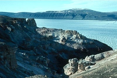
Near Nanisivik, Nunavut, Canada Photograph by Biz Agnew/ WWF
|
|
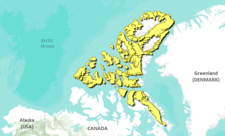
The HIgh Arctic Tundra ecoregion encompasses the majority of the Canadian northern Arctic archipelago, including most of Axel Heiberg and Ellesmere Islands, a significant portion of Baffin Island, the majority of Somerset Island and all of the remaining Queen Elizabeth Islands.
 Source: World Wildlife Fund
This entire ecoregion is classified as having a high arctic ecoclimate. The climate is very dry and cold, and mean summer temperatures in the north of the ecoregion, in the Sverdrup and Parry Islands, are as low as -1.5°C (and as high as 2°C in the south, on the Lancaster Plateau in western Baffin Island). Winter mean temperatures range between -32°C in the north and -23°C in the south. Precipitation is also very low, ranging mostly between 100 millimeters (mm) and 200 mm, with a few sites registering greater values (up to 400 mm) in the Baffin Island Uplands. The northern portions of the ecoregion–Ellesmere Island, and the Parry and Sverdrup Island groups–generally receive less precipitation than anywhere else in Canada, sometimes as little as 50 mm in a single year.
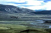 Vendom Fiord, Ellesmere Island, Nunavut, Canada. (Photograph by Douglas Hodgson/Used with permission of the Geological Survey of Canada & Natural Resources Canada)
 The physiography of this ecoregion varies widely across the landscape. The western portion of the ecoregion is underlain by flat-lying Paleozoic and Mesozoic sedimentary bedrock. The landscape is rugged and mountainous on the north and west coasts of Ellesmere and Axel Heiberg Islands, where ice-covered mountains reach 2,500 meters (m) in elevation. To the east and south, the landscape consists mostly of lowland plains covered with glacial moraine, marine deposits, and bedrock outcrops. It is in some cases severely ridged, as on the Parry Island plateau. East of Prince of Wales and Somerset Islands, the terrain is composed mainly of Precambrian granitoid bedrock, and tends to consist of plateaux and rocky hills. Most of the Queen Elizabeth Islands lie between 0 m and 1,000 m above sea level (asl), with greater elevations found in the east (between 300 m and 1,000 m), on the Lancaster and Borden Penninsula Plateaux. The Arctic Islands circumscribe a variety of oceanic conditions. In the northern half of the ecoregion, the waters are ice-fast, even through the summer. Towards the south, open waters are more common in the summer, but pack ice usually persists offshore. The permafrost is continuous and may extend to depths of several hundred meters (m).
Contents
Biological Distinctiveness
Plant species must be very robust to survive in this ecoregion’s climate. In the north, clumps of moss, lichen, and cold-hardy vascular plants such as sedge (Carex spp.) and cottongrass (Eriophorum spp.) are the dominant vegetation. Arctic willow (Salix arctica) and Dryas spp. occur infrequently, and mixed, low-growing herbs like purple saxifrage (Saxifraga oppositifolia), Kobresia spp. and arctic poppy (Papaver radicadum) can sometimes be found at lower elevations. In the southeast, the dominant vegetation is generally very similar, but, because of some milder climate, wet areas can develop up to about 60 percent of wood rush (Luzula spp.), wire rush (Juncus spp.), and saxifrage (Saxifraga spp.), with a nearly continuous cover of mosses. In all other instances, the vegetative cover is sparse and discontinuous.
Wildlife characteristic of the entire region include muskox (Ovibos moschatus), arctic hare (Lepus arcticus), arctic fox (Alopex lagopus), and caribou (Rangifer tarandus). Polar bears (Ursus maritimus) are common in coastal areas. Representative birds include king eider (Somateria spectabilis), rock ptarmigan (Lagopus mutus), northern fulmar (Fulmarus glacialis), plover (Charadrius spp. and Pluvialis spp.), hoary redpoll (Carduelis hornemanni), snow bunting (Plectrophenax nivalis), and other seabirds. Marine mammals include walrus (Odobenus rosmarus), seal (Phocidae), and a variety of whales (Cetacea). In addition, gyrfalcon (Falco rusticolus), jaeger (Stercorarius spp.), snowy owl (Nyctea scandiaca) and narwhal (Monodon monoceros) are more common in the south around the Lancaster plateau and sound.
Significant ecological features of this ecoregion include the global range of the endangered peary caribou (Rangifer tarandus ssp. pearyi), the global distribution of polar desert habitats with globally unique species assemblages of plants, vertebrates and mammals. This is one of only two ecoregions ( Middle Arctic Tundra ) with viable populations of high Arctic wolves (Canis lupus arctos). The ecoregion also includes nesting sites for Ross’ gulls (Rhodostethis rosea) and ivory gulls (Pagophila eburnea).
Conservation Status
Habitat Loss and Degradation
At least 98 percent of this ecoregion is considered to remain intact. Very small areas of habitat loss are attributed to coastal communities and terrain disturbance in their immediate vicinities. There are also abandoned oil and gas camps and seismic lines.
Remaining Blocks of Intact Habitat
The ecoregion can be considered as intact.
Degree of Fragmentation
This ecoregion is naturally fragmented due to the large number of islands that make up its composition. For much of the year, however, sea ice links the islands, permitting dispersal of large mammals.
Degree of Protection
- Polar Bear Pass National Wildlife Area - northern Northwest Territories - 2,624 km2
- Bylot Island Migratory Bird Sanctuary - northern Northwest Territories - 1,087.8 km2
- Prince Leopold Island Migratory Bird Sanctuary - northern Northwest Territories - 504 km2
- Seymour Island Migratory Bird Sanctuary - northern Northwest Territories - 8 km2
Types and Severity of Threats
Threats are relatively minor. One threat is atmospheric fallout, resulting in heavy metal and pesticide pollution. There is a risk of oil spills in coastal areas. Ecotourism will need to be carefully managed in order that nesting bird colonies, caribou calving grounds, and other sensitive wildlife species are not disturbed. With increased access, [hunting|over-hunting]] of caribou is a possibility. This is of particular concern for the population of Peary Caribou; in the last few years there has been a precipitous decline in population levels of this endangered animal.
Suite of Priority Activities to Enhance Biodiversity Conservation
- Complete designation of Northern Bathurst Island National Park, ensuring that the area includes Peary caribou calving grounds and that management plans are developed to prevent disturbance on caribou summer areas.
- Protect Bailey Point (Melville Island). This is an important refugia for muskox and a plant refugia.
- Develop and implement a recovery plan for Peary caribou.
Conservation Partners
- Canadian Arctic Resources Committee
- Ecology North
- Nunavut Wildlife Management Board
- World Wildlife Fund Canada
| Disclaimer: This article contains some information that was originally published by the World Wildlife Fund. Topic editors and authors for the Encyclopedia of Earth have edited its content and added new information. The use of information from the World Wildlife Fund should not be construed as support for or endorsement by that organization for any new information added by EoE personnel, or for any editing of the original content. |