Fraser Plateau and Basin complex
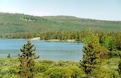
Nemaiah Valley, central British Columbia, Canada Photograph by Landquest Realty Corp
This ecoregion occupies much of the central interior of British Columbia. It is distinct from the drier 'interior' to the south and southeast, the cooler interior forests to the north, and coastal forests to the west.
Mean annual temperature for the region is 3°C, mean summer temperature is 12.5°C, and mean winter temperature is -7.5°C. Precipitation varies greatly; values of 250-300 millimeters (mm) per year occur in the area of the Chilcotin and Fraser River junction, and rise to 600-800 mm per year at higher elevations in the west. In general, the climate in this ecoregion is Boreal Interior Cordilleran.

This ecoregion covers the plateaus and plains of north-central British Columbia. The region is primarily underlain by flat-lying Tertiary and volcanic bedrock that is generally below 1000 meters (m) above sea level (asl) in the northeast, but rises to an elevation of 1800 m asl in the west. It has a rolling surface covered by thick glacial drift into which the Fraser River and its tributaries are incised.
Biological Distinctiveness
Vegetation of this ecoregion is transitional from the coastal forests to the west and the drier interior forests to the east. The subalpine zone is characterized by lodgepole pine (Pinus contorta) Engelmann spruce (Picea engelmannii) and alpine fir (Abies lasiocarpa). Montane forests include lodgepole pine, trembling aspen (Populus tremuloides), white spruce (P. glauca) and Douglas-fir (Pseudotsuga menziesii). Bunchgrass-dominated grasslands occur at valley bottoms along the Fraser and Chilcotin Rivers. Alpine tundra vegetation is also present at the highest elevations. Fire is probably the most important disturbance regime.
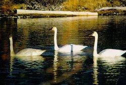 Trumpeter Swans (Olor buccinator), Nemaiah Valley, British Columbia. (Photograph by Landquest Realty Corp)
 Characteristic wildlife include caribou (Rangifer tarandus), coyote (Canis latrans), moose (Alces alces), bighorn sheep (Ovis canadensis), black-tailed deer (Odocoileus hemionus), wolf (Canis lupus), black bear (Ursus americanus), muskrat (Ondatra zibethica), lynx (Lynx canadensis), sandhill crane (Grus canadensis), blue grouse (Dendragapus obscurus), spruce grouse (D. canadensis), ruffed grouse (Bonasa umbellus), sharp-tailed grouse (Tympanuchus phasianellus) and migratory waterfowl.
The ecoregion contains western North America’s southern most stable (as of present) herd of woodland caribou (Rangifer tarandus spp. caribou) (approx. 1,500 animals). There are also large concentrations of bighorn sheep, as well as the largest concentrations of breeding pairs of Barrow’s goldeneye (Bucephala islandica) and bufflehead (B. albeola) in North America. One of the most northern extentions of dry grasslands in western North America, home to the Trirhabda beetle (Trirhabda spp.), occurs within the ecoregion.
Conservation Status
Habitat Loss
 Near the Baezaeko river, British Columbia, Canada. (Photograph by The Blackwater Company) It is estimated that only about 25 percent of the ecoregion remains as natural, intact habitat. Much of the remaining habitat was described as 'altered', although some parts of the ecoregion have been 'heavily altered' due to agricultural activities (particularly along major valleys and southern uplands). Wetlands have also been seriously impacted by agricultural development in this ecoregion. Additional impacts have occurred from hydro-electric impoundments, pulpwood harvesting and livestock grazing.
Remaining Blocks of Intact Habitat
- Tweedsmuir Park - west central British Columbia - contains important alpine and subalpine habitat, as well as important habitat for caribou.
- Itcha Ilgachuz Provincial Park - central British Columbia - contains important alpine and subalpine habitat, as well as important habitat for caribou.
- Churn Creek Provincial Park - central British Columbia - contains habitat for bighorn sheep and black-tailed deer.
- Carp Lake Provincial Park - east central British Columbia - wetland complexes
- Junction Sheep Range Provincial Park - central British Columbia - bighorn sheep range, northernmost bunchgrass ranges (including the northern distribution of the Trirhabda beetle).
Degree of Fragmentation
Habitat fragmentation is moderate but increasing rapidly in this ecoregion. Primary reasons for fragmentation include clearcutting, wetland conversions, river impoundments, highway/railway cooridors in key lowland valleys. Low and mid-elevation [[habitat]s] are far more fragmented than upper elevations.
Degree of Protection
- Tweedsmuir Provincial Park - 9,609.18 square-kilometers (km2)
- Itcha Ilgachuz Provincial Park - 1090 km2
- Churn Creek Provincial Park - 361 km2
- Tweedsmuir Recreation Park - 333.28 km2
- Taseko Provincial Park - 211 km2
- Carp Lake Provincial Park - 193.44 km2
- Kluskoil Lake Provincial Park - 156 km2
- Nazco Lakes Provincial Park- 80 km2
- Junction Sheep Range Provincial Park - 47 km2
- Lang Lake School House Provincial Park - 45 km2
Types and Severity of Threats
Presently, rapidly expanding logging practices are the primary threat to biodiversity in the next 20 years. Between 15 and 20 percent of the total standing volume is scheduled for harvest in the short term. This will result in additional fragmentation to forest habitat and loss of critical winter habitat for woodland caribou. Access is increasing to much of the ecoregion as logging roads are built into most of the valley lands.
Suite of Priority Activities to Enhance Biodiversity Conservation
- Sufficient winter habitat protection needs to be achieved to maintain stability for the woodland caribou herd in this ecoregion.
- Additional habitat protection is required for California bighorn sheep
- Wetland habitats require more protection.
Conservation Partners
- Canadian Parks and Wilderness Society, British Columbia Chapter
- The Nature Conservancy, British Columbia Nechako Environmental Society
- Northwest Wildlife Preservation Society
- Prince George Naturalists
- Williams Lake Environmental Society
- World Wildlife Fund Canada
Relationship to other classification schemes
The Fraser Plateau and Basin Complex (TEC 202 and 203) in central British Columbia occupies the Interior Plateau and foothills of the Coast Mountains, the Nechako Lowlands, the northern part of the Nechako Plateau, the southern portion of the Northern Rocky Mountain Trench, and the western flank of the MacGregor Plateau. This ecoregion incorporates a variety of Rowe’s forest regions. Montane forest sections include Central Douglas-fir (2), Northern Aspen (3) and Montane Transition, in addition to Interior Subalpine (2), Grassland and Tundra.
| Disclaimer: This article is taken wholly from, or contains information that was originally published by, the World Wildlife Fund. Topic editors and authors for the Encyclopedia of Earth may have edited its content or added new information. The use of information from the World Wildlife Fund should not be construed as support for or endorsement by that organization for any new information added by EoE personnel, or for any editing of the original content. |