Cascade Mountains leeward forests
|
|
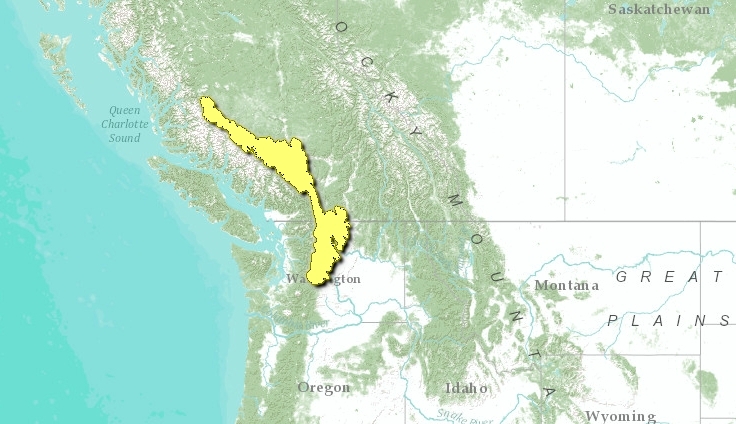
The Cascade Mountains leeward forests ecoregion stretches as a narrow band along a generally north-south axis along the leeward side of the Cascade Mountains that straddle the Canada-USA border in the province of British Columbia and the USA state of Washington. The ecoregion is classified within the Temperate Coniferous Forests biome, and exhibits relatively modest faunal biodiversity; for example, only 276 vertebrates are found in the Cascade Mountains leeward forests.
In the southern half of the ecoregion the mean annual temperature is 6°C, mean summer temperature is 15°C, and mean winter temperature is -3.5°C. In the northern half of the ecoregion, temperatures are approximately 2.5°C cooler. A strong climatic gradient exists from the moist coastal climate to the semiarid continental climate of the southern interior. Precipitation ranges from 300 millimeters (mm) in the south to 500 mm in the north, and also ranges from 600 mm in the east to 1200 mm in the west.
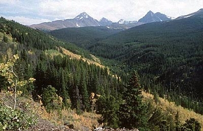
The southern half of the ecoregion consists of the Cascade Ranges, a mountainous upland within the southern Pacific Ranges. The Chilcotin Ranges compose the northern half of the ecoregion, and attain elevations of up to 2700 meters (m) above sea level. The Okanagan Range in the south extends along the Canada-USA border.
Contents
Biological Distinctiveness
Alpine tundra communities are comprised of Engelmann spruce (Picea engelmanii), Subalpine fir (Abies lasciocarpa) and Lodgepole pine (Pinus contorta). Montane forests are comprised of Lodgepole pine, Quaking aspen (Populus tremuloides), White spruce (P. glauca), and Douglas fir (Pseudotsuga menziesii) with a grassy understory. At the lower elevations in the eastern ecoregion there is a parkland of scattered Ponderosa pine (P. ponderosa) in a matrix of Bluebunch wheatgrass (Agropyron spp.) and Sagebrush (Atremesia tridentata) grasslands.
Mammals
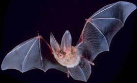
 Townsend's big-eared bat. Source: U.S. Government This ecoregion is home to Bighorn sheep (Ovis canadensis), Mountain goat (Oreamnos americanus), Grizzly and Black bear (Ursus arctos and U. americanus), Black-tailed deer (Odocoileus hemionus), Coyote (Canis latrans), Townsend's big-eared bat (Plecotus townsendii), and Mountain lion (Puma concolor).
Amphibians
There are only four amphibians found in the Cascade Mountains leeward forests, namely: Long-toed salamander (Ambystoma macrodactylum); Western toad (Anaxyrus boreas); Pacific chorus frog (Pseudacris regilla); and the Columbia spotted frog (Rana luteiventris).
Reptiles
There are merely three reptilian taxa that occur in this ecoregion: Northern alligator lizard (Elgaria coerulea); Western terrestrial garter snake (Thamnophis elegans); and the Northern rubber boa (Charina bottae).
Birdlife
Blue grouse (Dendragapus obscurus) and a gamut of raptors are found in the southern part of the ecoregion. The ecoregion also contains habitat for certain special status avifauna such as the Spotted owl (Strix occidentalis EN) and Cassin's finch (Carpodacus cassinii NT). Other representative avian species seen in the Cascade Mountains leeward forests include: Willow ptarmigan (Lagopus lagopus) and White-headed woodpecker (Picoides albolarvatus).
Fish
Considerable populations of salmon (Oncorhynchus spp.) use the Fraser River as a major migration corridor.
Conservation Status
Habitat Loss
Almost seventy percent of the ecoregion is considered to be intact habitat. A variety of human activities occur in the ecoregion, including logging, base metal mining, small areas of agriculture in the lower elevations, cattle grazing in lower elevation areas, and some sheep grazing in alpine areas and certain significant transportation corridors.
Remaining Blocks of Intact Habitat
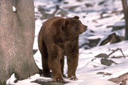
 Black bear. (Photograph by Tom Brakefield, California Academy of Sciences and CalPhotos)
 There are few large blocks of extant intact habitat left in this ecoregion. The principal remaining blocks include:
- South Chilcotin-Spruce Lake
- Stein Valley
- E.C. Manning Park
- Snowy Mountain
- TS42-OS
- Cathedral Provincial Park
Degree of Fragmentation
The Fraser River is a natural movement barrier to the north/south movement of small mammals, ungulates and carnivores. However, the construction of several major east-west highways and railways, accompanied by high fencing in some cases, has further disrupted the north-south movement of species such as Grizzly and Black bears, Wolverine and Fisher.
Degree of Protection
- Ts’il-os Provincial Park - British Columbia - 2332.4 square kilometers (km2)
- North Cascades National Park - north-central Washington
- Big Creek-South Chilcotin Provincial Park - British Columbia - 868 km2
- E.C. Manning Provincial Park - British Columbia - 658.84 km2
- Cathedral Provincial Park - British Columbia - 332.72 km2
- Lower Stein Wilderness Area - British Columbia - 330 km2
- Skagit Valley Recreation Park - British Columbia - 325.08 km2
- Marble Range Provincial Park - British Columbia - 180 km2
- Cascade Recreation Park - British Columbia - 166.8 km2
- Edge Hills Provincial Park - British Columbia - 130 km2
- Upper Stein Wilderness Area - British Columbia - 100 km2
Ecological Threats
Outside of protected areas, there are significant threats to forests on both the USA and Canadian sides of the border. There are additional threats from mineral exploration, and rural/recreational developments adjacent to some of the lakes in the ecoregion (e.g. Carpenter Lake).
Priority Activities to Enhance Biodiversity Conservation
- Protect areas established at Spruce Lake and Snowy Mountain in British Columbia.
- Restore suitable corridors to enable dispersal of mammalian species in a north-south direction.
Conservation Partners
- Canadian Parks and Wilderness Society, British Columbia Chapter
- The Nature Conservancy, British Columbia
- Nature Trust of British Columbia
- Northwest Wildlife Preservation Society
- World Wildlife Fund Canada
Relationship to Other Classification Schemes
TheCascade Mountains leeward forests is designated NA0507 by the World Wildlife Fund, lying within the Nearctic Realm. The Chilcotin Ranges (TEC 204) make up the northern part of this ecoregion, with the Interior Transition Ranges (TEC 208) occupying the southern part, and the smaller Okanagan Range area (TEC 210) in the far south also included. Ponderosa Pine and Douglas-fir montane forest, Interior and Coastal Subalpine forest, Grassland and Tundra all characterise this south-central element of British Columbia.
Neighboring Ecoregions
- Palouse grasslands, at the southeast
- Central and southern Cascades forests, to the southwest.
- British Columbia mainland coastal forests, to the west.
- Fraser Plateau and basin complex, to the north.
References
- Dean Apostol & Marcia Sinclair. 2006. Restoring the Pacific Northwest: The Art and Science of Ecological Restoration in Cascadia. Island Press. ISBN 9781610911030.
- Derek Hayes. 1999. Historical Atlas of the Pacific Northwest: Maps of exploration and Discovery. Sasquatch Books. ISBN 1-57061-215-3.
- C.Michael Hogan. 2008. Pseudotsuga menziesii, Dougas fir. iGoTerra. ed. N.Stromberg.
- Arthur R. Kruckeberg. 1991. The Natural History of Puget Sound Country. Seattle: University of Washington Press. ISBN 0-295-97477-X.
| Disclaimer: This article contains some information that was originally published by the World Wildlife Fund. Topic editors and authors for the Encyclopedia of Earth have substantially edited its content and added considerable new information. The use of information from the World Wildlife Fund should not be construed as support for or endorsement by that organization for any new information added by EoE personnel, or for any editing of the original content. |

