British Columbia mainland coastal forests
|
|
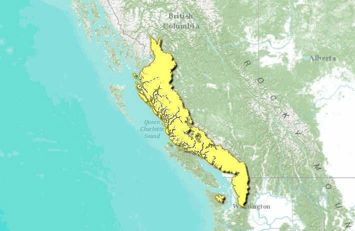
The British Columbia mainland coastal forests ecoregion occupies all of the British Columbia mainland coast and a small part of Washington state. The ecoregion extends inland about 150 kilometers (km) to the crest of the Coast Mountains.
A climatic gradient exists across the Coast Mountains to slightly drier and cooler conditions towards the interior. In the valleys of the southern half of this ecoregion, mean annual temperature is 6.5°C, but is higher in the far south. The summer mean temperature is approximately 14°C, and the winter mean is around -1°C, but again is also higher in the far south. Precipitation varies greatly with elevation, from 1,500 millimeters (mm) in the lower elevations up to 3,400 mm at higher elevations. Mean annual temperature in the northern half of the ecoregion is around 5°C, mean summer temperature is 13°C, and mean winter temperature ranges from -4.5°C to -0.5°C. Temperatures are significantly lower in the Nass Basin in the far north of the region. Precipitation ranges anywhere from 1,200 to 4,500 mm, depending on elevation.
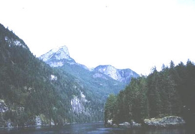
This ecoregion incorporates the northern part of the Cascade Mountains, the Pacific Ranges, and the Kitimat Ranges of the Coast Mountains, the Nass Ranges, and the Nass Basin. The Pacific Ranges in the south vary from sea level to 4,000 meters above sea level (masl), and the highest peaks are surrounded by expansive ice fields. Many large, steep-sided, transverse valleys, inlets, or fjords dissect this mountainous coastal region. The Kitimat Ranges in the northern part of the ecoregion form a saddle between the Pacific Ranges and the higher Boundary Ranges to the north.
Contents
Biological Distinctiveness
The Pacific Ranges encompass three different vegetation zones. Low-elevation [[coast]al] forests include productive stands of western hemlock (Tsuga heterophylla), western red cedar (Thuja plicata), and amabilis fir (Abies amabilis). The subalpine zone is dominated by forests of mountain hemlock (T. mertensiana) and amabilis fir with some yellow cedar (Chamaecyparis nootkatensis). Alpine tundra also includes sedge (Carex spp.)-dominated meadows, and lichen-colonized rock fields.
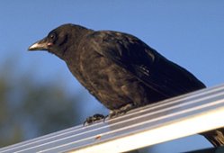
 Northwestern crow. (Photograph by Dr. Lloyd Glenn Ingles, California Academy of Sciences and CalPhotos)
 Characteristic wildlife of this ecoregion includes black-tailed deer (Odocoileus hemionus), black and grizzly bear (Ursus americanus and U. arctos), mountain goat (Oreamnos americanus), wolf (Canis lupus), mink (Mustela vision), Northern river otter (Lontra canadensis), blue grouse (Dendragapus obscurus), and waterfowl, and moose (Alces alces), woodland caribou (Rangifer tarandus spp. caribou), beaver (Castor canadensis), red fox (Vulpes vulpes), marten (Martes americana) and snowshoe hare (Lepus americanus) in the far north.
This ecoregion contains one of the most extensive mountain-fiord complexes in the world. A large number of species reach either their northern or southern limits along this extensive [[coast]al] ecoregion in western North America and an unusual white color form of the black bear (Kermode or Spirit bear) occurs on Princess Royal Island.
Conservation Status
Habitat Loss
It is estimated that approximately 40 percent of this ecoregion remains as fully intact habitat. Most of the disturbed habitat is in the low to mid elevation forests, particularly in the southern and northern ends of the ecoregion where logging has accessed many of the valleys. Transportation corridors in the valleylands are present, particularly south of Squamish, British Columbia.
Remaining Blocks of Intact Habitat
In addition to existing protected areas, there remain blocks of habitat in the central portion of the ecoregion. In the southern part of the ecoregion, the Skagit Valley on the British Columbia/Washington border is a somewhat smaller block of remaining habitat.
Degree of Fragmentation
The numerous [[coast]al] inlets and islands, combined with the mountainous terrain, create a certain level of natural fragmentation of habitat in this ecoregion. Valley bottoms and old-growth coastal rain forest have been significantly fragmented in more than 50 percent of this region by logging activities and logging roads. Such fragmentation and loss of habitat is of concern for species such as the spotted owl and grizzly bear that require large tracts of undisturbed habitat.
Degree of Protection
- Kitlope Provincial Park - west-central British Columbia - 3,172.91 km2
- Garibaldi Provincial Park - southwestern British Columbia - 1,946.54 km2
- Hakai Recreation Park - western British Columbia - 1,229.98 km2
- Fiordland Recreation Park - western British Columbia - 910 km2
- Gitnadoix River Recreation Park - western British Columbia - 580 km2
- Golden Ears Provincial Park - southwestern British Columbia - 555.96 km2
- Khutzeymateen Provincial Park - west-central British Columbia - 44,9.02 km2
- Pinecove Lake/Burke Mountain Provincial Park - southwestern British Columbia - 368.40 km2
- Homathko River/Tatlayoko Provincial Park - southwestern British Columbia - 340 km2
- Swan Lake Wilderness Area - west-central British Columbia - 190 km2
Types and Severity of Threats
The greatest threat to habitat in this ecoregion is logging, which is occurring or soon scheduled to occur throughout most of the valleys. South of 50 degrees latitude, urbanization and recreational development, especially in valleys, is a locally significant threat.
Suite of Priority Activities to Enhance Biodiversity Conservation
- More protected areas are required that represent the middle and lower elevation [[coast]al] rain forest communities.
- Proper enforcement of the British Columbia Forest Practices Code is required. Further damage to remaining salmon habitat must be avoided and other riparian habitats restored.
Conservation Partners
- Canadian Parks and Wilderness Society, British Columbia Chapter
- The Nature Conservancy, British Columbia
- Nature Trust of British Columbia
- Northwest Wildlife Preservation Society
- Sierra Club, Western Canada
- World Wildlife Fund Canada
Relationship to Other Classification Schemes
The British Columbia Mainland Coastal Forests encompass, from north to south, the Nass Basin, the Nass Ranges, the Coastal Gap, the Pacific Ranges, and the Cascade Ranges (TEC 187, 190-192 and 197). This ecoregion includes Southern and Northern Pacific Coast forest (2-3), Coastal Subalpine (3), Montane Transition (4), Northern Aspen (Montane 3) and Tundra forests.
| Disclaimer: This article contains information that was originally published by the World Wildlife Fund. Topic editors and authors for the Encyclopedia of Earth have edited its content and added new information. The use of information from the World Wildlife Fund should not be construed as support for or endorsement by that organization for any new information added by EoE personnel, or for any editing of the original content. |

