Central Canadian Shield forests
|
|
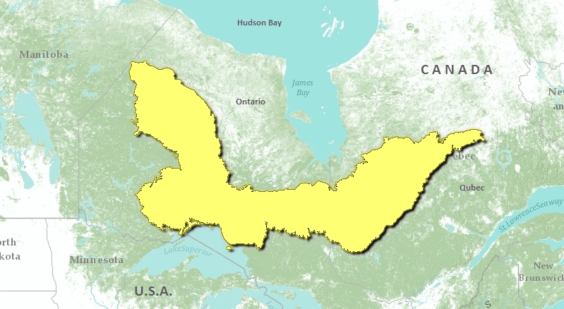
The Central Canadian Shield forests ecoregion occupies a U-shaped area stretching from the Ontario-Manitoba border in northwestern Ontario south and eastward to the north shore of Lake Superior and then northeastward into west central Quebec.
Mean annual temperature ranges from -2°C to 1.5°C, with mean summer temperatures from 12.5°C to 14°C, and mean winter temperatures from -17°C to -12°C. Mean annual precipitation varies across the ecoregion; annual precipitation is as low as 550 millimetres (mm) in the north, increasing to around 700-800 mm near Lake Nipigon, and is as high as 900 mm in the west. This area is described as having a moist and humid mid-to high-boreal ecoclimate.
 This region is underlain by the acidic, Archean bedrock of the Canadian Shield. Ridged bedrock outcrops are covered with calcareous, sandy to loamy till in the north, and a thin acidic sandy till in the south. The south-eastern region is bounded to the north by Palaeozoic bedrock of the Hudson Basin, toward which the coverage by wetlands increases. In the western region, sporadic discontinuous to isolated patches of permafrost with low ice content occur. In the east are the Mistassini Hills, with summits more than 1065 metres (m) above sea level.
Contents
Biological Distinctiveness
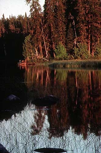
Black spruce is the climatic climax species in the north, as this area is dominated by coniferous forest. Fire occurs frequently, such that forest stands are composed of medium to tall closed stands of black spruce and jack pine (Pinus banksiana) with some paper birch (Betula papyrifera). South-facing slopes or warmer areas include greater proportions of quaking aspen (Populus tremuloides), white birch (Betula sp.), white spruce (Picea glauca), and balsam fir (Abies balsamea). Most of the south is dominated by mixed forest, characterized by white and black spruce (Picea mariana), balsam fir, jack pine trembling aspen and paper birch. Forest fires are an important natural disturbance in these coniferous forests.
Characteristic wildlife include moose (Alces alces), caribou (Rangifer tarandus), black bear (Ursus americanus), lynx (Lynx canadensis), snowshoe hare (Lepus americanus), wolf (Canis lupus), sharp-tailed grouse (Tympahuchus phasianellus), ruffed grouse (Bonasa umbellus), American black duck (Anas rubripes), and wood duck (Aix sponsa), as well as Canada goose (Branta canadensis) in the northern region, and hooded merganser (Lophodytes cucullatus) and pileated woodpecker (Dryocopus pileatus) in the west.
Outstanding features of this ecoregion include areas of rich clay plains which support some of the most productive boreal forest systems in North America. Major concentrations of disjunct arctic and western plant species are found along the north shore of Lake Superior. This ecoregion marks the most southern distribution of woodland caribou range remaining in North America.
Conservation Status
Habitat Loss
It is estimated that 40 percent or less of this ecoregion remains as intact habitat. Small parts of this ecoregion are heavily altered with some conversion to pasture, while more extensive areas have been significantly disturbed by large-scale, mechanized logging. More than 50 percent of this ecoregion has been logged and additional parts of the ecoregion are scheduled for logging in the near future.
Remaining Blocks of Intact Habitat
A large block north of Lake Nipigon in Ontario remains free of logging and major human settlements. In addition, a number of smaller, intact habitat blocks remain in both Ontario and Quebec (e.g. around Lake Mistassini, Quebec), but most of these are near the northern fringe of the ecoregion.
Degree of Fragmentation
Habitat fragmentation has principally occurred as the result of forestry practices (clearcuts and logging roads). There is one major transportation corridor through the Ontario portion of the ecoregion. Overall, species response to the habitat fragmentation indicates a relatively low impact, but one that is likely increasing as more habitat is altered.
Degree of Protection
- Wabakimi Provincial Park (regulated as of June 1997) - northwestern Ontario - approximately 8,950 square-kilometers (km2)
- Pukaskwa National Park - west-central Ontario, northern shore of Lake Superior - 1,877.8 km2
- Winisk River Provincial Waterway Park - 1,525 km2
- Missinaibi River Provincial Waterway Park - 991.52 km2
- Albany River Provincial Waterway Park - 951 km2
- Severn River Provincial Waterway Park - 829.6 km2
- Otoskwin-Attawapiskat River Provincial Waterway Park - 825.69 km2
- Kesagami Provincial Park - 559.77 km2
- Brightsand River Provincial Waterway Park - 412.5 km2
- Michipicoten Island Provincial Park - 367.4 km2
- Aiguebelle Provincial Park - 241.7 km2
Types and Severity of Threats
Large-scale forest clearcuts and fire suppression are major threats in this ecoregion. Many forests that have been subjected to mechanized logging are converting to aspen and birch instead of maintaining a dominance of conifer species. This change in ecosystem character is occurring over large areas, particularly in the central portion of this ecoregion. Forestry is rapidly expanding in this ecoregion and presents a significant threat to ecosystem integrity in the next 20 years.
Mining and mineral exploration are also present in both the Ontario and Quebec portions of the ecoregion, while hydro-electric development is a major threat to large areas of lowland habitat in Quebec. There are additional disturbances to natural habitats from major oil, gas trunk lines, and hydro transmission corridors.
Suite of Priority Activities to Enhance Biodiversity Conservation
- Establish protected areas in the following locations:
- Monts Otish in Quebec
- Lac Albanel in Quebec
- Rivière Témiscamie in Quebec
- Lake Nipigon-Nipigon River corridor in Ontario
- Expansion of Pukaskwa National Park in Ontario
- Candidate protected areas need to be identified in the claybelt section of this ecoregion.
Conservation Partners
- Conservation de la Nature de l'Environnement du Québec (RNCREQ)
- Environment North
- Federation of Ontario Naturalists
- Grand Conseil des Cris
- The Nature Conservancy, Quebec
- Northwatch
- Regroupement National des Conseils Régionaux
- UQCN - Union Québecoise pour la Conservation de la Nature
- The Wildlands League
- World Wildlife Fund Canada, Quebec Region
Relationship to Other Classification Schemes
The Central Canadian Shield forests stretch across northern Ontario and Québec. This ecoregion includes Lake Nipigon, Big Trout Lake, the Abitibi Plains, and Rivière Rupert Plateau (TEC 94-96 and 100). Boreal forest sections in this region are: Chibougamau-Natashquan, Gouin, Northern Clay, Central Plateau, Superior, Upper English River, Northern Coniferous and Forest-Tundra (Biome) (1b, 3, 4, 8, 9, 11, 13a, 22a and 32).
| Disclaimer: This article contains information that was originally published by the World Wildlife Fund. Topic editors and authors for the Encyclopedia of Earth have edited its content and added new information. The use of information from the World Wildlife Fund should not be construed as support for or endorsement by that organization for any new information added by EoE personnel, or for any editing of the original content. |

