Permafrost
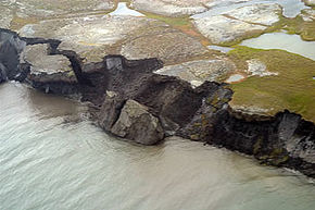 Permafrost thawing with slump to the Arctic Ocean. USGS A soil is considered permafrost if its temperature remains permanently below the melting point of water for at least two years. Such permafrost soil is ubiquitous in high latitude (e.g. in Siberia, Alaska and the Antarctic) but can also be found in mountainous areas at lower latitudes. Typically, the below-ground temperature will be less variable from season to season than the air temperature, with temperatures tending to increase with depth.
Permafrost typically occurs during glacial periods. The thickness of a permafrost layer can reach from a few decimetres to well over one kilometre, while it may extend in area from small patches of a few tens of square metres to thousands of square kilometres. Since our present glacial period is considered an interglacial within the fifth Ice age there are presently large areas of the Earth that are classified as permafrost. Permafrost formation may be considered a positive feedback loop for either global cooling or global warming cycles, based upon limited experimental observations.[1]
Contents
Classes of permafrost
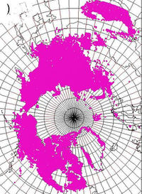 Mean 1990-2000 Arctic permafrost extent. USGS Conventional designations of permafrost[2] are as follows:
- Alpine permafrost is permafrost engendered by high altitudes, rather than latitude (e.g. conditions in the Himalaya, Pamir Mountain and High Andes ranges, and even at Kilimanjaro)
- Discontinuous permafrost occurs in the following scenario: If the mean annual air temperature is only slightly below 0°C, permafrost will form only in sheltered locations. Normally, permafrost is discontinuous only in microclimates where the mean annual soil surface temperature is between freezong and -5°C. In the moist-wintered areas, there may not be even discontinuous permafrost down to -2°C
- Extensive discontinuous permafrost is a subset of discontinuous permafrost, in which permafrost covers between 50 and 90 percent of the terrain; this circumstance characteristically occurs where mean annual temperatures range between -2 and -4°C.
- Sporadic permafrost is defined as the condition where permafrost cover is less than 50 percent of the areal extent and most often is found at mean annual temperatures between freezing and -2°C. Sporadic permafrost can be considered as a subclass of discontinuous permafrosts.
- Continuous permafrost occurs when the mean annual soil surface temperature remains below -5°C, in which case the influence of aspect cannot overcome the frozen soil.
- Subsea permafrost is a frozen seabed condition.
Thickness and persistence
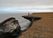 Permafrost block calved from
Alaskan Arctic coast. USGS
Deep permafrost layers are highly persistent, and conversely require a long time scale for formation.[3] The deepest permafrosts such as encountered in the Yukon are approximately 1300 meters in thickness. Formation times for such deep layers are on the order of 100,000 to 500,000 years; in fact, some deep permafrosts are thought to have persisted for the prior two million years. This persistence underscores the fact that, even though the climatic trend for the past 20,000 years has been an interglacial warming, we are still in the Earth's fifthIce age.
In some world regions of moderate latitude, including parts of central Europe, deep permafrost developed during the Pleistocene persists to depths of several hundred metres. Poland's Suwa?ki deep frozen soils are examples of such persistent frozen depths, even though the surface soils do not qualify as permafrost.It is interesting to note that the presence of a snow pack impedes the growth of permafrost depth, since it insulates the ground from the colder external air.
Methane fluxes
As permafrost melts methane is released into the atmosphere. This process has been occurring since the last glacial maximum approximately 20,000 years before present. Activities of man beginning in the early Holocene, including deforestation and intensive grazing, have added to this thawing process. Intensified combustion of fossil fuels and intensification of rice farming have also added to greenhouse gas production in the last several centuries. In any case, the release of methane constitutes a re-inforcing feedback loop by the release of more greenhouse gases.
Engineering on permafrost
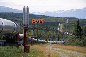 Trans Alaska Pipeline. Source: Luca Galuzzi Engineering for structures, roads and pipelines is challenging in permafrost settings. Seasonal thaw depth and the temperature of the frozen ground are key parameters to be addressed in the design of infrastructure in a permafrost environment. Most biogeochemical and hydrological processes in permafrost are confined to the seasonally thawed layer, which varies from tens of centimeters to meters in thickness. These parameters control important cryogenic processes, including creep, thaw settlement, the bond between frozen soil and embedded material, frost heave, and frost jacking (recurring foundation uplift caused by frost heave). Seasonal thaw depth and frozen-ground temperature both depend on soil surface temperature, heat flow from the interior of the earth, snow cover, vegetation and soil characteristics. Projects such as the Trans Alaska Pipeline have required extensive engineering to allow flexible movement of the pipeline to respond to the seasonal freeze thaw cycle.
Tundra
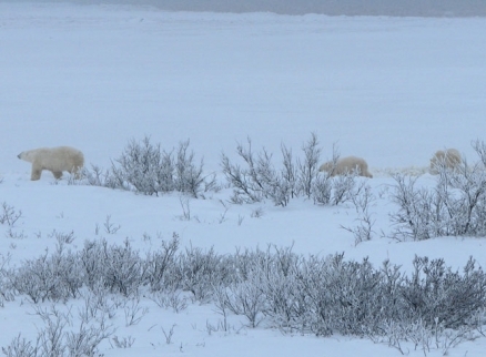
 Tundra landscape with polar bears and stunted vegetation.
Source: C.Michael Hogan Tundra is a biome for which subsoils are permafrost, where the frozen soil layer layer begins approximately 20 to 80 centimeters below the surface. Tundra is generally characterized by low growing vegetation, mosses and lichens, and lacking trees of normal stature. At the milder latitudes of the tundra limit, there are sparse occurrences of stunted trees, and some occurrence of Black spruce, which can tolerate a thin rooting zone.[4] The Arctic tundra includes parts of northern Russia, northern Scandinavia, northern Canada and Greenland, and the biome here includes some large terrestrial mammals; however, the Antarctic tundra, which includes the Antarctic Peninsula and certain sub-Antarctic islands such as the Auckland Islands, contain no large land mammals, but does hold penguins and certain seals.
Patterned ground
In the case of tundra regimes, there is a typical upper soil freeze thaw cycle which often creates distinctive patterns at the soil surface.[5] These patterns are influenced by the soil characteristics, local plant palette and micro-topography. A range of patterns arises in these different instances that combine from the vegetation, soil, local drainage and microclimate. The patterns themselves vary from polygons and circles to stripes.
In the case of polygons, the shapes are most commonly four, five or six sided and have characteristic diameters of five to 45 metres. In fact, the patterns are usually quite visible from low altitude aerial photographs. The process of formation starts with fine grained soil that contracts during the freezing cycle. These crevices fill with water subsequent to the spring thaw; then, the following winter, that water freezes, wedging the crack into a larger crevice. With successive cycles, the crevices enlarge both vertically and laterally.
References
Citation
Hogan, C. (2012). Permafrost. Retrieved from http://editors.eol.org/eoearth/wiki/Permafrost- ↑ Marcia Phillips, Sarah M.Springman and Lukas U. Arenson. 2003. Permafrost: proceedings of the eighth international conference on permafrost. 1322 pages.
- ↑ Hugh M. French and Olav Slaymaker. 1997. Canada's Cold Environments. McGill Queens Press. 340 pages
- ↑ Mariana Gosnell. 2007. Ice: The Nature, the History, and the Uses of an Astonishing Substance. University of Chicago Press. 340 pages
- ↑ C. Michael Hogan. 2008. Black Spruce: Picea mariana. GlobalTwitcher.com, ed. Nicklas Stromberg
