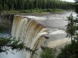
Muskwa-Slave Lake forests
This ecoregion occurs in the northeastern corner of British Columbia, the northwestern corner of Alberta, and much of the Mackenzie River valley in the southwestern Northwest Territories.
This ecoregion is classified as having a sub-humid mid to high boreal ecoclimate, with cool summers and very cold winters. Mean annual temperature ranges from -2.0°C to -6.5°C, mean winter temperature ranges from -18°C to -24.5°C, and mean summer temperature is around 12.5°C. Annual precipitation is between 250 millimeters (mm) and 500 mm on average.
The Mackenzie River Plain is a narrow northern extension of the boreal forest along the east side of the Mackenzie River. The Plain is a broad, rolling area lying between Mackenzie and Franklin mountains. The Horn Plateau extends from the Horn River west along the Willowlake River to the Mackenzie River. To the northeast and south, the plateau rises above the Great Slave Lake Plain and the Hay River Lowland regions. The Northern Alberta Uplands include the Caribou Mountains in northern Alberta and the Cameron Hills uplands that span the border with British Columbia and Northwest Territories.
Biological Distinctiveness
Vegetation consists of medium to tall, closed mixed stands of quaking aspen (Populus tremuloides), white spruce (Picea glauca), and balsam fir (Abies balsamea) with lesser amounts of balsam poplar (Populus balsamifera) and black spruce (Picea mariana). Organic blankets support open stands of stunted black spruce and some birch and shrubs. Sporadic, discontinuous permafrost with low to medium ice content is common throughout and associated with organic deposits. Wetlands and bogs cover 25-50 percent of the land. Fire is widespread among the forest and shrubland communities in this ecoregion.
One of the continent’s most diverse and intact large mammal systems occurs in this ecoregion. Woodland caribou (Rangifer tarandus ssp. caribou), moose (Alces alces), lynx (Lynx canadensis), grizzly bear (Ursus arctos), black bear (U. americanus), wolf (Canis lupus), snowshoe hare (Lepus americanus), grouse (Dendragapus spp.), waterfowl, deer (Odocoileus spp.), and elk (Cervus elaphus) are all found in the Muskwa Plateau in the southeast part of this ecoregion.
Large scale mammalian migrations occur within their natural range of variation. There are relatively undisturbed predator/prey systems, although human impacts are beginning to affect these systems. Bison (Bison bison) herds are found in the Athabasca Basin/Wood Buffalo National Park area.
Conservation Status
Habitat Loss and Degradation
Approximately 75 percent of the habitat is considered to remain intact. Seismic lines dissect the landscape every 10 kilometers (km) in northern British Columbia, parts of Yukon Territory and Alberta. Logging of riparian habitats has been extensive in some areas and is increasing.
Remaining Blocks of Intact Habitat
Most of the ecoregion is intact but there are local watersheds that have been very heavily impacted by logging.
Degree of Fragmentation
Habitat fragmentation is increasing due to the cumulative impact of seismic lines, logging and the MacKenzie valley highway and pipeline transportation corridors.
Degree of Protection
- Wood Buffalo National Park (a part of) - southern Northwest Territories and northeastern Alberta - 31,364.9 square kilometers (km2)
- Maxhamish Lake Provincial Park - northeastern British Columbia - 5.2 km2
Types and Severity of Threats
There is high potential for intensive logging in the Alberta portion of the ecoregion. Logging allocations are also being considered throughout most of the forested sections of this ecoregion. Upgrades to the transportation corridor following the Mackenzie Valley may increase access to wildlife in adjacent areas.
Suite of Priority Activities to Enhance Biodiversity Conservation
Protected areas are needed. These include:
- Grayling River - British Columbia
- Hay-Zama wetland complex - Alberta
- Mills Lake - Northwest Territories
- Liard River area - Northwest Territories
Conservation Partners
- Alberta Wilderness Association
- Canadian Nature Federation
- Canadian Parks and Wilderness Society, British Columbia Chapter
- Canadian Parks and Wilderness Society, Edmonton Chapter
- Ecology North
- Federation of Alberta Naturalists
- The Nature Conservancy, Alberta
- The Nature Conservancy, British Columbia
- Northwest Wildlife Preservation Society
- World Wildlife Fund Canada
| Disclaimer: This article is taken wholly from, or contains information that was originally published by, the World Wildlife Fund. Topic editors and authors for the Encyclopedia of Earth may have edited its content or added new information. The use of information from the World Wildlife Fund should not be construed as support for or endorsement by that organization for any new information added by EoE personnel, or for any editing of the original content. |


