Alberta-British Columbia foothills forests
|
|
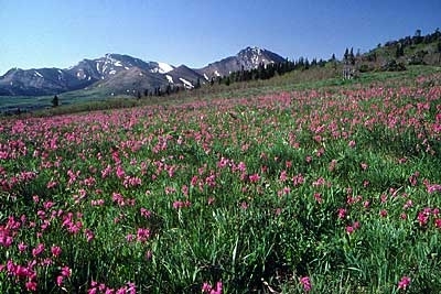
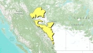
The Alberta-British Columbia foothills forests ecoregion occupies the Rocky Mountain foothills in western Alberta, Canada, as well as a small portion of east central British Columbia. Three disjunct geographic areas comprise this ecoregion, the central unit being the largest and the southern unit being quite small. Faunal species richness is low, as exemplified by only 250 vertebrate species occurring in the ecoregion.
Mean annual temperature ranges from -0.5°C in the north to 2°C in the southern portion of the ecoregion. Mean summer temperature ranges from 13°C in the north to 15°C in the south, and mean winter temperature ranges significantly, from -17.5°C in the north to -10°C in the south. Annual precipitation is even throughout the entire ecoregion (400-600 millimeters). This climate is classified as boreal southern Cordilleran.
The foothills of the Western Alberta Upland rise above the plains, and are mainly linear ridges, rolling plateau remnants, and broad valleys. Higher elevations range from 700-1,500 meters (m) above sea level. The Clear Hills Upland in the north has elevations in the range of 550 to 1050 m, and has steep slopes, some rolling plateau remnants, and broad, gently undulating valleys.
Contents
Biological Distinctiveness
Vegetation of the ecoregion is characterized by mixed forests of Lodgepole pine (Pinus contorta), Quaking aspen (Populus tremuloides) and White spruce (Picea glauca), with Balsam poplar (P. balsamifera), Paper birch (Betula papyrifera) and Balsam fir (Abies balsamifera). Aspen and open stands of Lodgepole pine occur on drier sites; Black spruce (P. mariana) and Tamarack (Larix laricina) are associated with wet sites. The Alberta-British Columbia foothills forests are transitional, marking mixed vegetation between boreal and Cordilleran vegetation. Fire is deemed the most important disturbance regime, although seasonal and year-to-year changes in precipitation can also alter species assemblages.
Mammals
Numerous mammalian taxa occur in the Alberta-British Columbia foothills forests, such as: Beaver (Castor canadensis), Black bear (Ursus americanus), Moose (Alces alces), Muskrat (Ondatra zibethica), Grey wolf (Canis lupus), White-tailed jackrabbit (Lepus townsendii) and Snowshoe hare (Lepus americanus).
The northern portion of this ecoregion contains an area known as the Chinchauga Hills, which contains two subspecies of Caribou (Rangifer tarandus), one a mountain subspecies and the other a woodland subspecies. Within the ecoregion there are some of the highest population densities of Moose in North America.
Birdlife
A number of avian species are found in the ecoregion, including: Sandhill crane (Grus canadensis), Sprague's pipit (Anthus spragueii VU), Saltmarsh sharp-tailed sparrow (Ammodramus caudacutus VU), Rusty blackbird (Euphagus carolinus VU), Olive-sided flycatcher (Contopus cooperi NT), Ruffed grouse (Bonasa umbellus), Spruce grouse (Dendragapus canadensis), and a variety of waterfowl are characteristic of this ecoregion.
Among rare ecological and evolutionary phenomena are a variety of eastern warbler species (Parulinae) that reach their northwestern limits in North America here. In addition, Halfway Valley is a major migration stopover for migrating sandhill cranes.
Reptiles
There are a small number of reptilian taxa within the Alberta-British Columbia foothills forests: Western terrestrial garter snake (Thamnophis elegans) and Common garter snake (Thamnophis sirtalis).
Amphibians
There are few amphibians present in the Alberta-British Columbia foothills forests. Anuran taxa found here are: Boreal chorus frog (Pseudacris maculata) and Wood frog (Lithobates sylvaticus).
Conservation Status
Habitat Loss
There is virtually no completely undisturbed habitat in this ecoregion. Most of the ecoregion has been ranked as ‘altered’ with a smaller portion ranked as ‘heavily altered’.
A variety of extensive human use is prevalent in this ecoregion, including logging, agricultural expansion from the south that is converting aspen forests to cereal and hay crops, livestock grazing in community pastures, intensive seismic exploration, and pipelines.
Remaining Blocks of Intact Habitat
There are no completely unaltered large habitat blocks. The largest site with the least disturbance appears to be the Chinchauga Hills.
Degree of Fragmentation
Agriculture, roads and logging have fragmented the ecoregion. To a lesser extent, an extensive network of seismic lines creates divisions, but their narrow character is less disruptive to some species than roads. They do, however, create opportunities for increased access to otherwise more remote areas.
Degree of Protection
- Goose Mountain Ecological Reserve - western Alberta - 12.46 square kilometers (km2)
- Whitecourt Mountain Natural Area - western Alberta - 5.44 km2
Types and Severity of Threats
Much of the territory in this ecoregion has been allocated to various kinds of industrial resource uses several times over. Forestry, oil, and gas, and agriculture combine to place a high human demand on the landscape. Predator control of ‘nuisance’ animals, or under the guise of wildlife management, is a serious threat to both Grizzly bear (Ursus arctos) and Gray wolf (Canis lupus) populations in this ecoregion. The caribou populations in the Chinchauga Hills are severely threatened due to habitat loss and degradation.
Priority Activities to Enhance Biodiversity Conservation
- Protect the Chinchauga Hills
- Protect riparian habitats throughout the ecoregion
Conservation Partners
- Alberta Wilderness Association
- Canadian Parks and Wilderness Society, Calgary/Banff Chapter
- Canadian Parks and Wilderness Society, Edmonton Chapter
- The Nature Conservancy, Alberta
- World Wildlife Fund, Canada
Relationship to Other Classification Schemes
The Western Alberta Upland (TEC 145 and 146) occurs as two separate areas in west-central Alberta. The small, southern region extends into the foothills, and the larger area crosses into British Columbia. The Clear Hills Upland, which comprises the northern section of the Foothills Forests (TEC 137), spans the British Columbia-Alberta boundary north of the Peace River district. This ecoregion falls within the Lower and Upper Foothills sections of the Boreal forest region (19a and 19c).
Neighboring Ecoregions
- Alberta Mountain forests, west of the central disjunctive unit
- Canadian Aspen forests and parklands, to the north and east and betwixt the northern and central disjunctive units
- Mid-Continental Canadian forests, at the northeast of the central disjunctive unit
- North Central Rockies forests, to the west of the southern disjunctive unit and betwixt the central and southern disjunctive units
References
- Sylvie Gauthier et al., eds. 2009. Ecosystem management in the Boreal forest. Presses de l'Universite du Quebec
- W. F. Lothian. 1987. A Brief History of Canada's National Parks. Environment Canada. ISBN 0-662-15217-4.
- J. M. Hoekstra; Molnar, J. L.; Jennings, M.; Revenga, C.; Spalding, M. D.; Boucher, T. M.; Robertson, J. C.; Heibel, T. J. et al. 2010. Molnar, J. L., ed. The Atlas of Global Conservation: Changes, Challenges, and Opportunities to Make a Difference. University of California Press. ISBN 978-0-520-26256-0
- Bill Mathews and Jim Monger. 2005. Roadside Geology of Southern British Columbia. Mountain Press Publishing Company. ISBN 0-87842-503-9.
- Taylor H. Ricketts. 1999. Terrestrial ecoregions of North America. Island Press
| Disclaimer: This article contains some information that was originally published by the World Wildlife Fund. Topic editors and authors for the Encyclopedia of Earth have edited that content and added substantial new information. The use of information from the World Wildlife Fund should not be construed as support for or endorsement by that organization for any new information added by EoE personnel, or for any editing of the original content. |

