Atlantic Ocean

Seas of the World ![]() The Atlantic Ocean sits in an S-shaped basin that runs in a north-south direction, bounded by Europe and Africa on the east and by North and South America on the west. An ocean basin is a large, deep depression that gradually slopes towards the sea floor, forming the shape of a basin. The Atlantic is divided into the North and South sections by the Equator and is connected to the larger Pacific Ocean via the Arctic Ocean to the north, and by the Drake Passage to the south.
The Atlantic Ocean sits in an S-shaped basin that runs in a north-south direction, bounded by Europe and Africa on the east and by North and South America on the west. An ocean basin is a large, deep depression that gradually slopes towards the sea floor, forming the shape of a basin. The Atlantic is divided into the North and South sections by the Equator and is connected to the larger Pacific Ocean via the Arctic Ocean to the north, and by the Drake Passage to the south.
Running directly through the Atlantic Ocean is the great Mid-Atlantic Ridge, an underwater mountain range that runs from Iceland, all the way to 58ºS latitude. The Mid-Atlantic Ridge separates the Atlantic Ocean into two main basins that are further divided into a number of other basins north and south of the equator. In the North Atlantic, the most prominent ocean basins are: the Baffin basin, the Hudson basin, the Labrador basin, the Newfoundland basin and the very large North American Basin that extends from just off the Grand Banks of Newfoundland to approximately the same latitude as Puerto Rico.
Contents
Size
The Atlantic Ocean has an area of approximately 82 million square kilometers not including its surrounding seas and bays. When the Mediterranean, Black, Baltic, North, Norwegian-Greenland, and Caribbean Seas, Baffin and Hudson Bay and the Gulf of Mexico are also considered, its area rises to about 106 million square kilometers. It is the world’s second largest ocean, and covers approximately one-fifth of the Earth’s surface. This vast expanse of water holds approximately 350 million cubic kilometers of water, and receives about four times more inflow from the rivers of surrounding land regions than either the Pacific Ocean or Indian Ocean.
Atlantic Ocean Properties
Salinity
The waters at the surface of the North Atlantic Ocean are saltier than those of any other ocean - but not near Canada! The reasons for this high salinity are related to the flow of currents, the rate of evaporation, precipitation, river inflow, and melting of sea ice. Currents may bring high salinity water into the North Atlantic from surrounding saltier seas. The rate of evaporation plays a role in determining salinity. The higher the rate of evaporation, the higher the salinity, because the salt to water concentration increases as water evaporates. Increased levels of precipitation, as in equatorial regions, will decrease salinity by diluting the salt water. River inflows also dilute salt concentrations, and so too does the melting of sea ice. The outflow from the Mediterranean Sea brings very salty water into the North Atlantic, and is the largest contributing factor to the salinity of this part of the ocean.
Around the Canadian coast, the Atlantic waters are not as salty. The Gulf Stream, which originates in the warm climate of the Gulf of Mexico also has a high evaporation rate. It has a salinity value of about 35%. Water from the Gulf Stream that enters the North Atlantic retains this value. This is about the closest that high salinity water gets to Canada's east coast! There are factors in Atlantic Canada that reduce salinity. For one, the precipitation rate is higher than the rate of evaporation, so that rainwater dilutes the Atlantic Ocean near the Maritimes, lowering salinity values. Rivers along the east coast also bring freshwater into the ocean, again lowering salinity values. The melting of Arctic sea ice, further reduces the salinity of surface waters along Canada’s Atlantic coasts.
Temperature
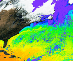 The water temperatures of the Atlantic are very apparent in this color enhanced photograph. (Source: Biodiversity Institute of Ontario)
 The temperature of the surface waters in the Atlantic Ocean is governed by the flow of sea-surface currents. Worldwide, the waters around the equator are warmest. As a result, currents moving away from the equator bring warm water to both the north and south Atlantic coasts. The North Equatorial Current moves warm water to the North Atlantic, while the South Equatorial Current spreads both north and south, bringing warm water to the east coasts of both North and South America. In the North Atlantic, the strong Labrador Current spreads a cold stream as far down as latitude 40ºN. By contrast, the Gulf Stream brings warm water as far up as the coast of Norway. The junction where these two extreme temperatures meet - around the Grand Banks of Newfoundland - is striking, and is known as the “cold wall.”
In deeper waters, the North Atlantic temperatures can vary from about 2.5°C at the very bottom to about 5°C at 3,000 feet. The immense tides of the Bay of Fundy continually stir the cold deep water up to the surface of the North Atlantic, making the surface waters cool, even in midsummer. The summer sun does succeed in warming the surface inshore waters of the Atlantic, often to a maximum of 15-20°C. In the winter, however, the temperatures of these same coastal waters drop to just above freezing. The North Atlantic deepwater currents bring cold water to the south, lowering deep water temperatures in the South Atlantic by about 2°C.
Atlantic Ocean Floor
The Atlantic Ocean is thought to be the youngest of all oceans. It was formed about 180 million years ago when a large continent called Pangea and ruled by dinosaurs, split down the middle. The split formed two separate landmasses now known as North and South America to the west, and Eurasia and Africa to the east. The separation of one landmass into two occurred as the result of the horizontal movement of the continental plates - a process known as continental drift. This widely accepted theory of the formation of the Atlantic Ocean stems from a broader theory known as plate tectonics. The theory of plate tectonics states that the earth’s crust is comprised of huge plates of solid rock slowly moving at about the same rate as a fingernail grows. If these plates move apart, oceans form between them. If they collide, [[mountain]s] form. The movement of continental plates also causes volcanic activity and earthquakes. As the continental plates that lie to the sides of the Atlantic continue to pull apart, the Atlantic grows, at a rate of about 1.8 - 2.4 centimeters per year.
Mid-Atlantic Ridge
 (Source: Biodiversity Institute of Ontario)
 In the middle of the Atlantic, a vast underwater mountain range rises from the ocean floor, and extends almost the entire length of the ocean. This submarine Mid-Atlantic Ridge owes its formation to the movement of the continental plates on either side of the ocean. As these plates slowly separate, they leave gaps in the earth’s crust. This allows molten rock from beneath the earth’s crust to reach the surface, forming a new part of the ocean floor. As the molten rock seeps through the gap at some pressure, it spews upward, forming a ridge. The Mid-Atlantic Ridge is so tall, that it actually rises above sea level in many places, forming volcanic islands. The Azores, Ascension, St. Helena, and Tristan da Cunha (Tristan Da Cunha-Gough Islands shrub and grasslands) all arise from this great Atlantic range. Iceland too is a submarine ridge island. It sits at the northern crest of the Mid-Atlantic ridge, and is the largest island of the ridge. These islands are volcanic in origin, and thus do not have any foundation on continental rock.
Atlantic Continental Shelf
The Canadian Atlantic [[coast]line] reaches from New Brunswick’s Bay of Fundy to the northeastern tip of Baffin Island. A ledge of land that stretches as far as 1,300 kilometers offshore surrounds the continent. These ledges are called the continental shelves, and stretch along the entire expanse of the Atlantic coast. The continental shelf stretching along the Atlantic coast is ranges in width from about 150 kilometers off the coast of Labrador, to 480 kilometers in the Grand Banks of Newfoundland. This is considerably wider than the Canadian Pacific continental shelf.
Hudson Strait
The waters off the coast of Baffin Island are usually thought of as belonging to the Canadian Arctic, but in oceanographic terms, these waters are Atlantic. This region called Hudson Strait, is very deep - up to 500 meters close to the shoreline. The floor of the Hudson Strait shelf is comprised of many cliffs and deep glacier -formed canyons.
Labrador Shelf
Directly next to the Hudson strait is the Labrador Shelf, a part of the continental shelf that encompasses the entire Labrador [[coast]al region]. This shelf reaches out about 150 kilometers to sea, and is very shallow, often only 70 meters as far as two kilometers offshore. However, at the edge of the Labrador Shelf, a sudden and steep continental slope appears that plunges to depths of over 3,000 meters!
Newfoundland Shelf
The Newfoundland Shelf is situated along the northeastern coastline of this island. This region of the Atlantic continental shelf typically stretches around 50 kilometers into the ocean, along most of the coast. However, it can reach out as far as 200 kilometers offshore in some areas, where it rises up to form high banks at its edge before dropping down to the ocean floor. Although these areas are shallow, they are deep enough to be safe for navigation by fishing vessels and tankers. Glaciers have gouged out deep depressions in some parts of the shelf leaving several basins - sloping circular pits - and troughs, which are longer, steeper and more flat-bottomed than basins.
Grand Banks
The Grand Banks of Newfoundland are located off the southeast coast of the province. In this area, the continental shelf is exceptionally wide. The Grand Banks is a 730-kilometer stretch of shallow continental shelf that extends as far as 480 kilometers from the coast. These banks are submarine plateaus that rise from the underlying continental shelf, to just 25-100 meters below the ocean surface. The average depth of these banks is around 150 meters, but there are many troughs in the shelf floor of glacial origin that are as deep as 200 meters or more.
These surface waters - in fact, the Grand Banks are the best place to spot these enormous chunks of glacial ice as they drift down from Greenland. The cold Labrador Current runs over the Grand Banks, and when warm air passes over this water, a dense fog forms. The fog, shallow waters and drifting icebergs make navigation difficult in this region.
Scotian Shelf
The Scotian Shelf is an extension of the Atlantic shelf extends out to sea about 100 kilometers along the 120-kilometer stretch of the east coast of Nova Scotia. The shelf is relatively shallow, with an average depth of around 90 meters. However, areas around the shelf plummet to depths of 4,000 meters to the south, and 3,000 meters to east, where the shelf meets the Atlantic Ocean floor. Sable Island, located 300 kilometers southeast of Halifax, is surrounded by a number of shallow banks, ranging from 25 to 100 meters in depth. The shallow ocean floors around this island have long been a threat to ships and many have sunk. These wrecks, scattered on the ocean floor surrounding this solitary island, have given the area it’s nickname - ‘the Graveyard of the North Atlantic'. Troughs and basins separate the shallow banks in this area. A large underwater canyon, called ‘the Gully’, forms a long pit into the shelf that reaches a depth of 1,000 meters.
Bay of Fundy
The Bay of Fundy is a unique region on the Atlantic coast, as it is home to phenomenally high tides. The head of the bay, especially the regions of the Minas Basin and Chignecto Bay experience the highest tides in the world! To find out why, and how high, visit the Atlantic Tides section. The floor of the Bay of Fundy is on average, about 50 meters deep, and never reaches farther down than 150 meters. Various small islands, channels, reefs and shoals line the floor of the bay. The channels are relatively shallow grooves in the seabed, whereas the reefs and shoals are [[rock]y] expansions or elevations in the seabed that reach to near the surface of the bay and pose a danger to navigating sailors. The high tides in the Bay of Fundy, in combination with the complex sea floor, result in numerous whirlpools, turbulent waters and the upwelling of deeper waters to the surface.
North Atlantic Currents
 Low tide at the Hopewell Rocks, Bay of Fundy. (Source: Biodiversity Institute of Ontario)
 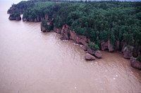 High tide at the Hopewell Rocks, Bay of Fundy. (Source: Biodiversity Institute of Ontario)
 The North Atlantic Ocean is a complex mix of currents that twist and wind around each other. The vast area that is covered by the Atlantic results in a wide variation in conditions both above and below the water. These conditions create and direct the movement of water throughout the massive body of water that is the Atlantic Ocean.
Cause of Ocean Currents
Ocean currents result from two processes - the action of wind on the surface of the water, and from variation in water temperature that causes movement- a process known as convection. Convection occurs because the oceanic waters heat up becoming less dense. This water moves above the cooler water, and give off its heat to the surrounding environment. As it cools, it begins to sink, and the process begins again. Convection results in the continual circulation of ocean water on a global scale.
There are many factors that determine the strength of a current, as well as the route it will follow. Winds have the most important influence on the flow of currents, but tides, precipitation, evaporation rates, shape of the ocean floor, and inflow from rivers and adjacent seas are also important. The major currents in the North Atlantic Ocean flow along the eastern North American coast from the Gulf of Mexico to the tip of Labrador.
Measuring Currents
To measure the speed of currents, oceanographers have planted - or moored - instruments in the water that can calculate the rate of water movement at various times during the day. Other instruments known as drifters float on the surface and determine the paths and direction of the water. Aside from their speed, ocean currents are measured by the rate of their flow in millions of cubic meters per second. To put this into perspective, consider the outflow of water from the Mediterranean Sea into the North Atlantic Ocean. Flow from the Mediterranean Sea into the Atlantic Ocean occurs at a rate of 1 to 3 million cubic meters per second. By comparison, the Amazon River flows into the Atlantic at a rate of 0.2 million cubic meters per second. All of the rivers flowing into the Atlantic contribute water at a rate of 0.6 million cubic meters per second.
Labrador Currents
The cold Labrador Current flows from the Arctic, southward along the Labrador Coast. Some of the cold water from this current enters the Gulf of St. Lawrence, but the most of the water continues to move south, dividing into two arms. One of these arms, the cold inshore current, moves along the southern coast of Newfoundland, dipping around the edge of the province to enter the Gulf of St. Lawrence. The rest of the inshore branch of this current continues south and contributes to the Nova Scotia Current. The offshore branch of the Labrador Current is slightly warmer, and is responsible for the movement of pack ice and icebergs around the Grand Banks.
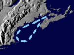
The Gulf of St. Lawrence
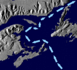 The flow of water through the Gulf of St. Lawrence. (Source: Biodiversity Institute of Ontario)
 Within the Gulf of St. Lawrence, the currents flow in a counterclockwise direction, with the cold Labrador Current, giving the basin a characteristically Arctic quality. Water from the Labrador inshore current enters the Gulf of St. Lawrence at the most southwesterly point of Newfoundland and continues northward along the west coast. This current is deflected west by the north shore of Quebec, joins with the Gaspé current, continues south and finally moves out of the Cabot Strait where its name is changed to the Cape Breton Current.
The Nova Scotia Current
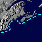 The Nova Scotia Current. (Source: Biodiversity Institute of Ontario)
 As the Nova Scotia Current moves southwest over the Scotian Shelf, it mixes with offshore waters as well as water from the Labrador Current and the Cape Breton Current. The Nova Scotia Current passes around the southern tip of Nova Scotia where it enters the Gulf of Maine. Once past the Gulf, it flows southward as the Coastal Current.
The Gulf of Maine
 Movement of water through the Gulf of Maine. (Source: Biodiversity Institute of Ontario)
 Off the west side of Nova Scotia and the east coast of New Brunswick lies the Bay of Fundy. To the south, the Bay of Fundy joins the Gulf of Maine. As in the Gulf of St. Lawrence, the current in the Gulf of Maine moves in a counterclockwise direction. The current, fed by the Nova Scotia Current, flows out of the Bay of Fundy and along the coast of New Brunswick all the way to Cape Cod. The stream then turns northward and returns to the Bay of Fundy. The runoff from nearby rivers, along with the strong tides moving into the Gulf of Maine drive its currents. The circular movement is also directed by Coriolis forces, which are exerted by the Earth’s rotation on all objects at the Earth’s surface. Currents in the northern hemisphere generally move in a counterclockwise direction, while currents in the southern hemisphere tend to move in a clockwise direction.
The Gulf Stream
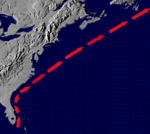 The warm Gulf Stream moves up the eastern coast of the United States and Canada, bringing warmer conditions to the continent. (Source: Biodiversity Institute of Ontario)
 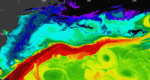 The Gulf Stream shows up bright red in this satellite image. (Source: Biodiversity Institute of Ontario)
 The Gulf Stream flows north from the Gulf of Mexico, bringing warm, salty water all the way up the east coast to just short of Nova Scotia. This current is of particular importance in warming the Maritime Provinces, as it redistributes the heat from the Caribbean to the cold North Atlantic. The large, fast Gulf Stream current flows at a rate of 150 million cubic meters per second; that’s equivalent to 30,000 Olympic sized pools full of water being moved every second! This current is not only responsible for warming the east coast of North America, but it also cuts across the Atlantic to warm the shores of northern Europe.
North Atlantic Tides
 (Source: Biodiversity Institute of Ontario)
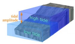
 The Atlantic Ocean is in a constant state of flux. While [[wind]s] and currents make waves, the sun and moon also interact to cause daily fluctuations in ocean levels. The sun and moon both pull the surface of the earth towards them, and oceanic waters are particularly affected by this attraction. The gravitational pull on the oceans causes water to bulge towards the orbiting moon. The varying position of the moon creates high and low tides. The tidal bulge created when ocean waters are pulled toward the moon is the high tide. Between each high tide, there is a low tide. As the moon rotates around the earth each day, water is displaced from the side of the earth facing the moon and also from the side of the earth facing away from the moon. The bulging of the waters on both sides of the earth occurs in response to the moon’s orbit. Because each orbit takes 24 hours and 50 minutes, there are usually two high tides and two low tides a day. However, because each orbit takes slightly longer than 24 hours, the timing of the high and low tides shift each day. When the sun and moon are aligned - during the full moon and new moon - the gravitational pull is greater causing very high tides and very low tides called spring tides. By contrast, when the moon and the sun are not aligned - in the first and third quarters of the lunar cycle - their gravitational forces partially cancel each other out, and the tides range is less. These tides are called neap tides.
Tidal Ranges at the Arctic and Maritime Coasts
 (Source: Biodiversity Institute of Ontario)
 Over most of the Atlantic coast and the rest of the world, the average difference between water levels at high tide and at low tide - tidal amplitude - is two meters. However, there is variation. The continental shelf in Hudson Strait is very shallow and this allows tidal amplitudes to reach around five to nine meters in this area. The shallow shelf causes the incoming tides to be much higher because the sea floor is higher. The very shallow Ungava Bay in northern Quebec has tidal amplitudes of around 15 meters. Tidal amplitudes along the coastal regions of the Labrador shelf are generally around three meters, and as the shelf becomes steeper further down the coast the amplitudes decrease. Off the coast of Newfoundland, where the continental shelf is relatively deep, tidal amplitudes are only about 1 meter. By contrast, in other regions, such as the Bay of Fundy tidal amplitudes are as great as 16 meters.
Bay of Fundy
The greatest tidal amplitude in the world occurs in the Bay of Fundy - located between Nova Scotia and New Brunswick. Ungava Bay, on the north coast of Quebec is a close second. The Minas Basin at the head of the Bay of Fundy regularly shows a tidal amplitude of 16 meters between high and low spring tides. The reason for the extreme tides are the strong Atlantic [[wind]s] that push water into the Bay of Fundy, causing a rocking movement. This oscillating movement happens in synchrony with the tides, driving the water higher into the Bay than along the coast. The shape of the bay also facilitates the high tidal amplitudes. Its basin-like shape narrows to a tip and suddenly becomes very shallow. Because water is being squeezed into an enclosed area, it has no where else to go but up, and therefore rises to a substantial height. Ancient Micmac folklore suggested that the extraordinarily high tides in the Bay of Fundy were caused by a mighty whale that splashed its tail into the water with such a force that the water continues to slosh back and forth from the impact, even to this day.
Interesting Fact
As the tides come in, Nova Scotia actually tilts! The high tides in the Minas Basin bring in about 14 billion metric tonnes twice daily, causing this small province to bend a little under the immense weight of the water.