Arctic Ocean
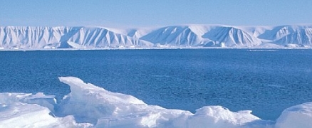
Ice is the dominant feature of Arctic marine ecosystems. It continuously sculpts the coastal landscape and acts as a major limiting factor to all biological activity. Two distinct zones are distinguished in the Arctic region based on ice: the Arctic Basin marine region is characterized by the year-round presence of sea ice (Sea ice in the Arctic), while the other Arctic subregions have ice-free periods ranging from less than a month to up to four months.
The Arctic coast (including islands) encompasses 68% of Canada's coastline, stretching 165,000 kilometers (km) from James Bay and Baffin Island to the Yukon.
The region exhibits a wide range of coastal landforms and reliefs fashioned by the processes of volcanism, glaciation, faulting and folding. The tidal range is generally less than 0.5 meter (m) in the northern and western sectors but increases to 1.0-5.0 m in the east and south.
Contents
Arctic Sea Ice
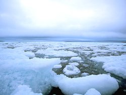
The Arctic Ocean waters are so cold that they develop a thick layer of sea ice on the surface during most of the year. The cold waters of the Arctic would seem to be inhospitable for life, but a rich ecosystem is present.
Sea Ice Formation
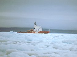
Salt lowers the freezing temperature of water, so that seawater freezes at about -2° C, whereas pure water freezes at 0°C. When the air temperature drops in the Arctic, a thick layer of seawater becomes ready to freeze all at once. The first signs of freezing are changes in color and texture as millions of tiny floating ice needles form, creating a dense “soup” called frazil ice. As the temperature falls further, the frazil ice thickens and traps pockets of salty seawater, or brine, within its layers creating a slushy mixture called grease ice. Eventually the grease ice accumulates, reaching a thickness of up to 1 m. In response to gravity, the pockets of brine move downward, and within a few weeks accumulate in the lower layers. As a result the ice at the surface contains little salt. Their removal from the upper layers increases its freezing point, aiding the change from grease ice to solid ice. Sea ice thus freezes solid from the top layer down. Eventually, all of the salt water is drained and the ice layer is frozen solid into pack ice. During the winter, the area of the Arctic Ocean covered with pack ice expands to form a continuous vast sheet. When melting occurs in the spring and summer, the pack ice retreats and breaks up into smaller pieces.
Types of Sea Ice
There are two forms of pack ice in the Arctic. The winter ice pack consists of annual ice, which melts in the spring and freezes again in the fall. Multiyear ice, which remains frozen throughout the summer, forms farther north in two regions: In the central part of the Arctic Ocean, there is the massive permanent polar pack, otherwise known as the Arctic or polar ice cap, that slowly rotates clockwise as a unit. The summer ice pack, which makes up the other region of multiyear ice, surrounds the permanent polar pack, and breaks up in the summer. These broken pieces of ice block many of the channels between the Arctic islands year-round.
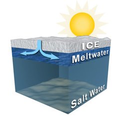
Multiyear Ice
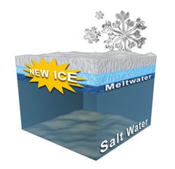
Multiyear ice remains frozen year-round, but still goes through a cycle of changes. The surface layer of this ice melts in the summer and the water then drains through pores in the ice to the bottom. This salt-free meltwater remains floating beneath the ice atop the denser salt water. In the winter, the meltwater refreezes as a layer on the bottom of the pack ice. One year at a time, the layers travel upward in a continuous cycle of loss and replacement. This cycle prevents the multiyear ice from thickening indefinitely. Multiyear ice forms the permanent polar pack in the center of the Arctic Ocean, as well as the summer ice pack that surrounds the permanent polar ice pack, and breaks up in the summer. Unlike annual ice, the summer ice pack never completely melts.
Annual Ice
Annual ice typically reaches a thickness of about 2 [[meter]s] over the winter. This type of pack ice begins to form by the middle of September, and by the end of October the ice field is almost solid along the coasts. As winter progresses, the annual ice extends offshore, connecting some islands with a solid sheet of sea ice. The thickness of the ice increases until May at which point it begins to thaw, with shallow blue pools forming on the ice surface. Rising summer [[temperature]s] cause the ice to melt further and eventually it breaks up. Cracks form that soon widen into channels or leads that separate the ice pack into chunks called floes. Floes sometimes collide with each other, and break into many pieces. Ice breakup occurs in early July in the low Arctic, and at the end of the month in the high Arctic. The ice density declines until late August, but by mid-September the freezing cycle begins again.
Segments of the ice pack that are firmly frozen to the shore are known as landfast ice. Offshore winds push ice away from the coast creating a gap of open water between the landfast ice and the pack ice - a shore lead. The winds also push the pack ice further out to sea, causing the drifting floes to collide and ride up over each other, or hummock. The result is a distinct ridge of jumbled ice blocks.
The loose, floating pieces of ice present in the summer scour the shorelines, preventing most plants and animals from settling in shallow water. This makes the intertidal zone, the area between the shoreline and the near shore bottom, much more barren than it is in other marine ecosystems.
Where to Find Arctic Sea Ice
About 12-13 million square kilometers of the Arctic Basin are covered by ice in winter. Additional sea ice (Sea ice in the Arctic) covers much of Baffin Bay and Hudson Bay, as well as the Labrador Sea. Nearly all of the Arctic and sub-Arctic shores are ice-bound throughout the winter. By late summer, the amount of Arctic sea ice is reduced to about 9 million square kilometers. During this season, loose pack ice from the Arctic moves southward along the east Greenland coast and from Baffin Bay down the Labrador coast into the north Atlantic Ocean. Although lanes of water open in the summer along the mainland, many of the channels in the Canadian archipelago remain ice-clogged year-round.
Polynyas
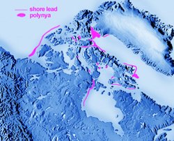
A polynya is a large area of open water surrounded by sea ice that is found in the same region year after year. Although polynyas can be hundreds of kilometers wide, their surface area is far less than the area of sea ice which surrounds them. However, the open waters of polynyas are very important to life in the Arctic Ocean. Polynyas teem with animal and plant life. It is only here, where the sea ice is absent, that the sun’s energy directly reaches the waters. Snow and ice ordinarily reflect much of the sun’s light energy, but the open waters of polynyas absorb it. Phytoplankton in the polynya use this energy to produce a nutrient rich grazing area for zooplankton. Feeding on these small animals are whales and fishes that in turn feed seals, walruses and polar bears. Often seen as oases in the harsh climate of the Arctic marine environment, polynyas have intrigued scientists for more than a century.
Formation
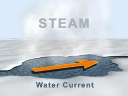
Polynyas occur in areas where swiftly moving sea currents prevent the freezing of surface water. Many polynyas are small, measuring only a few hundred square kilometers, and may freeze over at the height of winter. The larger polynyas, however, stay open all winter, although they may shrink in size in extremely cold [[temperature]s]. A distinct characteristic of all polynyas is that they are recurrent. The largest Arctic polynya, North Water, occurs at the head of Baffin Bay, and is like an inland sea surrounded by ice. This polynya was discovered in 1616, and is usually about as large as Lake Superior!
Compared to the surrounding air, the waters of a polynya are so warm that steam billows up. The average temperature of the waters within a polynya is about 0°C, and it never dips below -2°C, the freezing point of seawater. Polynyas allow heat from warm ocean currents to escape; this is important in the regulation of the Earth’s temperature.
In calm weather, a layer of new ice can form across a polynya in minutes. Inevitably, a strong wind or wave smashes this new ice layer, driving it out to sea and once again opening the surface of the polynya. This process occurs repeatedly, making polynyas an important source of new Arctic sea ice.
Leads
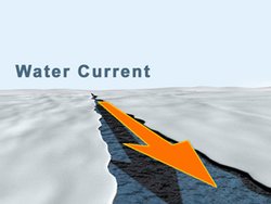
A lead is a fracture or large crack in the sea ice that results in a passageway of open water. Leads are less important to sea life than the open areas of [[polynya]s], but they are still important to many organisms. Leads provide important arteries for the navigation of marine mammals and birds.
Leads can occur almost anywhere that sea ice is packed relatively loosely. They may appear suddenly, and tend to open and close over a period of just a few hours following changes in winds or tides. There are places, however, where wide, predictable leads form between the landfast ice and the free-floating pack ice. These long-lasting leads are created by winds blowing offshore that push ice away from the coast, causing the pack ice to aggregate. These distinct leads provide open water for new ice formation.
Leads can often be detected from a great distance because they make the clouds above them appear dark. This occurs because the open water in leads absorbs sunlight (Solar radiation), which is normally reflected off ice or snow. This causes a dark streak to appear on the underside of the clouds above. This phenomenon is called "watersky".
Arctic Ocean Basin
The Arctic Ocean Basin is a large, deep depression that is situated under the cover of the Arctic permanent polar ice cap. This depression gradually slopes towards the seafloor in the shape of a basin or bowl. The Arctic Basin extends from the edge of the permanent ice cap in the northern part of the Beaufort Sea to the northern tip of Greenland. It runs along the northern edge of the Queen Elizabeth Islands to the tip of Ellesmere Island.
The Abyss
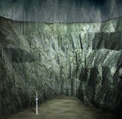
Abyssal plains are the incredibly deep and extremely level regions of the ocean floor - the flattest places on the planet! The slow, smoothing motions of currents along the ocean floor contribute to the formation of these plains. They are surrounded by submarine ridges or by the edges of the continental shelves. Some of these flat regions reach depths of over 4,000 [[meter]s], and stretch for distances of more than 500 kilometers. The depth of the Arctic basin ranges from 2,500 to 4,400 meters; that’s at least 5 times the height of the CN Tower! The average depth of basins in the rest of the world’s oceans is only around 2,000 meters, although certain areas of the Pacific Ocean are the deepest points recorded. Until the middle of the 20th century, it was believed that the Arctic Ocean was comprised of one large flat basin. In the 1950s, however, scientists discovered that the Arctic basin is divided into two main basins, which are themselves divided into four smaller basins by submarine ridges.
Currents
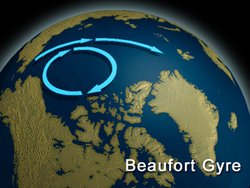
The dominant current in the Basin is the Beaufort Gyre, one of the two main currents of the Arctic Ocean. This current causes the polar cap to rotate continuously in a clockwise direction. The Beaufort current brings warm water from the Atlantic Ocean into the Arctic Ocean Basin by way of the Greenland Sea. However, only surface waters are exchanged because towering submarine ridges form walls, both around and across the basin, that prevent the exchange of deep waters. This results in a stagnant pool of very cold water (about -1ºC) at the bottom of the Arctic Basin.
Towering Mountains
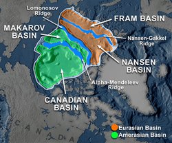
Towering mountain ranges known as submarine ridges run through and around the Arctic Ocean basin. These ridges were formed when the earth’s continental plates slowly separated, leaving gaps in the earth’s crust. Molten rock moved up into the gap, forming a new part of the ocean floor - the ridges that now divide the Arctic Basin into many sub-basins. Some of these submarine ridges run in straight lines for over 1,500 kilometers, and are steep and narrow, having widths of only about 200 meters. A number of peaks and valleys occur along the ridges, with crests rising to within a kilometer of the ocean surface.
The central submarine ridge, the Lomonosov Ridge, runs 1,770 kilometers from Ellesmere Island to the New Siberian Islands, a distance equivalent to that separating Toronto from Halifax! This ridge divides the Arctic Basin into two main basins: the Eurasian Basin - also called the Nansen Basin, and the Amerasian Basin - also known as the North American or Hyperborean Basin. Within the Eurasian Basin, the Nansen-Gakkel Ridge runs from east to west, dividing the basin into the northern Fram Basin, and the southern Nansen Basin. The geographic North Pole is located over the floor of the Fram Basin. The Nansen Basin is the smallest of the sub-basins within the Arctic Ocean. The Barents Abyssal Plain, an incredibly flat expanse, is located in the heart of the Fram Basin, at depths of over 4,400 meters.
The Alpha-Mendeleev Ridge divides the Amerasian Basin into the Canadian Basin and the Makarov Basin. The Makarov Basin is comprised of two abyssal plains, the Wrangel Abyssal Plain and the very deep Siberian Abyssal Plain, that lies 4,000 meters below the ocean surface. The Canadian Basin is the largest sub-basin of the Arctic Ocean, and is comprised of the Chukchi and Mendeleev Abyssal Plains at depths of 2,100 and 2,900 meters. The Canadian Abyssal Plain also lies in the Canadian basin, and is the deepest region in this part of the Arctic Ocean, reaching depths of about 3,850 [[meter]s].
The Ocean Floor
Due to the extreme ice conditions, the floor of the Arctic Ocean has been studied less than that of any other ocean. In the late 1800s, bathymetry measurements -the measurement of depths - were made by lowering a heavy weight attached to many meters of piano wire over the side of the ship. This method was not only tedious, but also inaccurate, because currents caused the weight to descend on an angle. Moreover, it was was slow because each depth measurement required lowering the line. Today, bathymetry is carried out using echo sounding. This involves sending a sound pulse to the ocean floor where it is reflected back to its source. By measuring the time it takes to make this return trip, with information on the speed of sound in water, the depth can be accurately estimated. This technology, while much used in other oceans, has been used less in the Arctic. However, as a result of studies from ice islands, icebreakers and, particularly, submarines, we now have a fairly good indication of water depths. Nonetheless, there are still many areas of the Arctic Ocean where no soundings have ever been made, and its general topography has only been estimated. See the Arctic Ocean Basin section for more information on the bathymetry of the Arctic Ocean.
To directly examine the composition of the sediments and rocks on the Arctic Ocean floor, samples of the bottom are obtained through a process known as coring. This process involves dropping a narrow tube down to the ocean floor where it penetrates into the seabed about 3 meters. This tube captures a core of sediment - mineral or organic particles that have settled on the ocean floor from the upper water layers. By examining these sediments, geologists can determine changes in the physical environment, climate and ecosystems through time. These sediments often contain the skeletons of sea life that tell the tale of past Arctic ecosystems. These sediments have revealed that until 5 million years ago, the Arctic was a far warmer place, and was likely free from ice. So far, the oldest sediments that have been collected from the Arctic Ocean floor are eighty million-year-old black muds, and sixty-seven million-year-old silicaceous oozes.
Snow and Ice

Most Arctic icebergs come from the Greenland ice cap, although a few originate from the glaciers on Ellesmere, Devon and Baffin Islands. At any given time there are more than 10,000 icebergs afloat in the eastern Arctic waters of Baffin Bay and Davis Strait - by far the best places to go iceberg watching! Arctic ocean currents usually confine icebergs to eastern Arctic waters, carrying them south past Baffin Island and Labrador. During winter, Arctic icebergs get frozen into pack ice, but they eventually melt away as they drift south. Only the largest Arctic icebergs last long enough to complete the 2-3 year journey to the Grand Banks off Newfoundland. It was one of these mammoth icebergs that gouged the hull of the Titanic on its maiden voyage in 1912, dooming over 1,500 passengers to a chilling death.
Iceberg Formation
Although icebergs float on ocean waters, they are composed of freshwater. An iceberg is simply an extraordinarily large mass of ice that has broken off from an ice cap or glacier where it met the sea. The first stage of iceberg formation occurs when part of a glacier or ice cap that has been pushed into the sea, begins to float on the water. Tides and wave action subsequently cause stress fractures, causing a piece of the glacier to break off and a new iceberg is born! This process is termed calving.
An iceberg’s extraordinary blue and white coloration is a reminder of its glacial origins. Glacial ice appears blue because pure ice absorbs other colors more rapidly than blue. This color appears in the deepest layers of the ice that are under such high pressure that all of the air bubbles have been forced out of the ice. By contrast the surface layers of the iceberg are white because the air bubbles trapped in the snow layers reflect much of the incident light. These air bubbles also result in iceberg fizz. As an iceberg melts, fizzing results from the release of gases that have been held under pressure, trapped in bubbles for thousands of years!
Sizes of Iceburgs
Icebergs can range in height from 60 to 200 [[meter]s], over half the height of the CN Tower! Large icebergs in the Arctic may weigh as much as 10 million tons. Because ice and water have different densities, ice floats. However, because ice is only slightly less dense than water, most of an iceberg is submerged. In fact, the visible top of the iceberg reflects only about one-ninth of its total mass. The large underwater base of an iceberg can cut deep grooves in the sea floor, called ice scours, similar to a plow moving through a field. In fact icebergs often get stuck in the mud on the sea floor. Because the bulk of each iceberg is underwater, their movement is under the control of sea currents rather than winds.
Ice Shelves
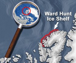
Ice shelves are formed when a freshwater ice cap extends out to sea. In the Arctic, ice shelves are only located along the north coast of Ellesmere Island. The Ward Hunt Ice Shelf is the largest and most important of these shelves. Ice shelves consist of a combination of ice from glaciers and sea ice (Sea ice in the Arctic). Pieces break off the freshwater part of the shelf to form ice islands, the flat icebergs of the Arctic Ocean. A layer of sea ice then freezes to fill the open space left behind. As a result, an ice shelf is actually a patchwork of both sea ice and freshwater ice - a pattern that is actually visible from the air.
Ice Islands
Ice islands are large, flat masses of ice that break away from ice shelves. In the Arctic, the source of these islands is the Ward Hunt Ice Shelf on northern Ellesmere Island. Ice islands are different from the pack ice that forms from seawater. Like icebergs, ice islands are largely composed of freshwater of glacial origin. There are an estimated 30 or 40 ice islands afloat on the Arctic Ocean at any one time. Ice islands vary in size from a few tens of meters in width to tens, or even hundreds, of square kilometers in area.
The Polar Ice Cap
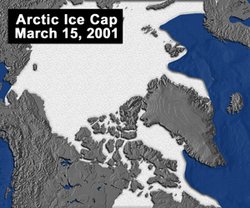
The polar ice cap is the permanent mass of sea ice that forms a jagged circle around the North Pole, covering about 70 percent of the Arctic Ocean. The polar ice cap floats, and rotates as a unit with the North Pole at its center, in a clockwise motion, driven by easterly currents and winds. It takes about 4 years to complete a single rotation. This ice cap is as much as 50 [[meter]s] thick in some places and has an estimated area of about six million square kilometers, which is about 1% of the entire earth’s surface! In summer, the edges of the polar ice cap sometimes break into chunks of ice, called floes. The broken ice floes that surround the permanent ice pack are known as the summer ice pack. Since the polar ice cap is constantly in motion, moved by wind and currents, there is no way to permanently mark the location of the geographic North Pole. There are other smaller land-based ice caps in the Arctic; the largest of these is the ice cap that covers much of Greenland. All of these land-based ice caps are entirely comprised of glacial ice.
Unlike the Arctic polar ice cap, the Antarctic ice cap exists on top of a landmass and is therefore composed entirely of freshwater. The average thickness of this permanent ice cap is over 3 kilometers.
Continental Shelf
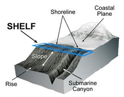
Each continent is surrounded by a ledge of land that stretches as far as 1,300 kilometers offshore. These ledges are called the continental shelves, and in the Arctic these shelves underlie about two-thirds of the Arctic Ocean. This is not surprising since the Arctic Ocean is nearly landlocked, bordered by Greenland, Canada, Alaska, Russia and Norway. The average depth of the world's continental shelves is about 200 meters, but most of the Arctic continental shelves are at least 200 meters deeper than this. The difference is likely a result of the last glaciation; the weight of the ice pushed the northern continents down into the earth's crust. Since its removal, the earth has rebounded, but not enough time has passed for the continental shelves in the Arctic to reach their original depths.
The Greenland Shelf
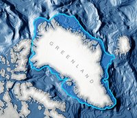
The Greenland continental shelf extends for nearly 300 kilometers off the west coast into the Greenland Sea, at a depth of 350 to 450 meters. The Greenland shelf, like all other continental shelves, extends until it reaches the shelf break. At this point the shelf begins to slope downwards, sometimes at a very steep gradient. Often, deep channels that form in the shelves extend from the ocean floor all the way up the slope to the top of the shelf. Glaciers probably gouged out these channels, as they moved along the shelf. The Greenland shelf is marked by many of these channels, a reminder of the glaciers that carved this land, and continue to exist, in Greenland's extensive ice cap. A number of glacier-formed channels and canyons also cut through sections of this continental shelf, which lie off Ellesmere and Axel Heiberg islands. However, the glacier-free coasts of the other Queen Elizabeth Islands are devoid of these extensive channels.
The Alaskan Shelf
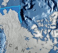
The Alaskan continental shelf extends 120 kilometers into the Beaufort Sea. This narrow shelf has a depth of 800 [[meter]s] and is marked by canyons and channels. Closer to shore, this shelf is covered with ice-gouges, produced by the grounding of very deep sea-ice and ice islands, both of which travel along the shelf from east to west, carried by a clockwise current.
The Siberian Shelf
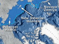
The continental shelf off of the coast of Siberia is the widest continental shelf in the world, extending 1,200 kilometers offshore. This shelf is very shallow, with an average depth of only 100 meters, and from it arises many islands including Wrangel Island, Novaya Zemlya, and the New Siberian Islands. The Siberian shelf is characterized by near-shore sand bars and ice gouges. Despite its shallowness, little is known about the topology of most of this vast shelf, but the floor of its encompassing seas; the Kara, Laptev and East Siberian Seas, are marked by deep canyons and ridges, likely formed by current erosion.
The European Shelf
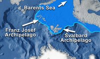
The European continental shelf lies within the Barents and Norweigan Seas. From this shelf arises the islands of the Franz Josef and Svalbard archipelagos. The shelf is complex, with many ridges, banks and valleys, but its depth variation is better known than that of the Siberian shelf. The depth of this shelf ranges from 150 to 300 meters, and the shelf floor is covered with rocks and boulders. In shallower areas, smooth, water-polished pebbles cover the bedrock.
Beaufort Shelf
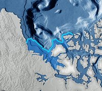
The Beaufort Shelf is a well-studied feature of the Beaufort Sea. This shelf is only about 110 kilometers wide and reaches a maximum depth of about 500 meters. It is the only shelf to have a large number of underwater pingos. Pingos are typically terrestrial formations associated with permafrost. They are oval-shaped hills of frozen sediment and bedrock that have a solid ice core. Pingos are ordinarily formed when surrounding permafrost traps water, which then freezes. This newly frozen ice forces the surrounding permafrost into a large hill, filling its core with solid ice. The similarity of the underwater pingos to their terrestrial counterpart indicates they probably share the same origin. The submarine pingos on the Beaufort Shelf average 400 meters in diameter and are about 30 meters high! Since their first discovery, several hundred pingos have been found and it is likely that more have yet to be charted. These hills present a hazard to ships in the western Arctic Ocean.
Currents
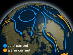
Currents are the circulation system of oceans, which move water from place to place. These movements are controlled by gravity, wind, and the rising and sinking of water in different parts of the world, due to varying temperature. Temperature has a great effect on the density of water. As water warms, it expands and becomes less dense, causing it to rise to the surface. In warm climates this water evaporates quickly, thereby increasing its salt concentration. The increased salt concentration increases the surface water's density, causing it to sink. This in turn causes the upwelling of cooler waters that are then warmed by the sun, and the cycle continues. Forces linked to the Earth's rotation also govern the direction of currents. These Coriolis forces cause ocean currents to move clockwise in the Northern Hemisphere, and counterclockwise in the Southern Hemisphere.
Main Arctic Currents
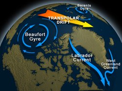
The Arctic surface waters extend to a depth of about 46 [[meter]s], and are far less salty than the waters below. The deeper Arctic waters near the ocean floor are very salty and therefore quite dense, and so do not flow readily. Generally, the surface waters of the Arctic Ocean circulate in a large clockwise rotational pattern moving from east to west around the polar ice cap. This rotating pattern, known as a gyre, occurs as a result of the clockwise winds that typically occur in this region. Only surface waters are exchanged via ocean currents because towering submarine ridges prevent the exchange of very deep waters. The lack of movement in the deep waters has caused a stagnant pool of very cold water to accumulate at the bottom of the Arctic Basin.
Known as the Beaufort Gyre, the Arctic current slowly swirls the surface waters of the Arctic basin, turning the Polar Ice Cap along with it, making one complete rotation about every 4 years. The other predominant current in the Arctic Ocean, the transpolar drift stream, carries water and ice from Siberia, across the pole and down the east coast of Greenland, joining the East Greenland current. This current flows in response to input from Siberian rivers, and a predominant westerly wind that pushes Arctic surface water eastward into the Atlantic.
Within the Barents Sea, a smaller gyre flows in a counterclockwise direction, with warmer Atlantic waters from the south mixing with colder Arctic waters in the north. This counterclockwise movement occurs in response to a counterclockwise wind system that moves across the Barents Sea. The Barents Sea current is generally weak and variable, as are the equivalent gyres that occur in the Norwegian and Greenland Seas. An additional current, the West Greenland Current, dominates the waters off the coast of Greenland, south of Davis Strait. As the West Greenland current approaches Davis Strait, it joins the Labrador Current, and then continues northward into Baffin Bay where it cools down dramatically.
Inflow to the Arctic Ocean
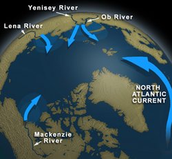
Ocean currents in the Arctic Ocean are not only influenced by wind direction, but also by the inflow from the rivers that discharge into it. Water enters the Arctic Ocean from many sources, but the Mackenzie River in Canada and the Ob, Yenisey and Lena Rivers in Siberia are dominant. The North Atlantic Current provides about 60% of the inflow to the Arctic Ocean bringing warmer water from the Atlantic Ocean. Some water also moves into the Arctic Ocean from the Bering Sea and the Pacific Ocean, by way of the Bering Strait.
Outflow from the Arctic Ocean
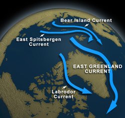
Since sea levels generally remain constant, the influx of water from these various waterways must be matched by an outflow. Due to the low [[temperature]s], evaporation rates are very low in the Arctic, so most of the outflow is via currents. Water flows from the Arctic Ocean into the Pacific and Atlantic Oceans, as well as into a number of surrounding seas. By far, the greatest volume of water leaves the Arctic Ocean through the passage between Greenland and Spitsbergen. This enormous outflow creates the cold East Greenland Current in the Greenland Sea. A weaker cold current, the Labrador Current, flows south through Smith Sound and Baffin Bay. A considerable amount of water also flows from the Arctic Ocean into the northern Barents Sea forming the East Spitsbergen and Bear Island Currents.
Arctic Currents and Climate
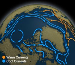
The snow and ice that cover the Arctic reflect about 90% of the sun's energy, so the Arctic is constantly losing heat. However, the ocean currents also exchange heat; currents from the Atlantic bring warm water into the Arctic, while currents traveling southwards discharge cold water. The strong southward currents flow along the shores of northeastern North America and Asia, cooling the climate in these regions. Conversely, the North Atlantic Drift and the Japan Current warm the northwestern shores of Europe and North America, as well as the Arctic.
