Puerto Rico
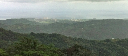
Source: Dave Delaney/Flickr
Countries and Regions of the World Collection  Puerto Rico is a self-governing unincorporated territory of the United States located in the northeastern Caribbean Basin, east of the Dominican Republic and west of the Virgin Islands. It is home to four million people.
Puerto Rico is composed of an archipielago that includes the main island of Puerto Rico and a number of smaller islands and keys, the largest of which are Vieques, Culebra and Mona.

The main island of Puerto Rico is the smallest by land area and second smallest by population among the four large islands of the Greater Antilles, which also include Cuba, Hispaniola, and Jamaica.
Populated for centuries by aboriginal peoples, the island was claimed by the Spanish Crown in 1493 following Columbus' second voyage to the Americas.
In 1898, after 400 years of colonial rule that saw the indigenous population greatly diminished and African slave labor introduced, Puerto Rico was ceded to the US as a result of the Spanish-American War.
Puerto Ricans were granted US citizenship in 1917.
Popularly-elected governors have served since 1948.

In 1952, a constitution was enacted providing for internal self government. In plebiscites held in 1967, 1993, and 1998, voters chose not to alter the existing political status.
Its major environmental issues include erosion and occasional droughts, the latter causing water shortages.
Puerto Rico has an important location along the Mona Passage - a key shipping lane to the Panama Canal.
The capitol, San Juan, is one of the biggest and best natural harbors in the Caribbean.
Many small rivers and high central mountains ensure land is well watered; south coast relatively dry; fertile coastal plain belt in north.
Contents
Geography
Location: Caribbean island between the Caribbean Sea and the North Atlantic Ocean, east of the Dominican Republic
Geographic Coordinates:18 15 N, 66 30 W
Area: 13,790 square km (8,870 sq km land and 4,921 sq km water)
Coastline:501 km
Maritime Claims:
Territorial sea to12 nautical miles; and,
Exclusive economic zone to 200 nautical miles
Natural Hazards: Periodic droughts; hurricanes.
Terrain: Mostly mountains with coastal plain belt in north; mountains precipitous to sea on west coast; sandy beaches along most coastal areas.Thehighest point isCerro de Punta (1,339 m).
Climate: Tropical marine, mild; little seasonal temperature variation.
Capital: San Juan, Puerto Rico, San Juan
Ecology and Biodiversity
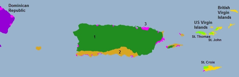
Source: World Wildlife Fund
1. Puerto Rican moist forests
2. Puerto Rican dry forests
3. Bohamoan-Antillean mangroves
57% of Puerto Rico was forested in 2003, up from 32% in 1990. The two small offshore islands of Vieques and Culebra were even more forested at 85% and 88% respectively. The island’s diverse forests, holding over 500 native species, reflect its equally diverse physiography. Three forest types are recognizerd:
| Subtropical moist forest: | 2,589 km2 (999 mile2) or 51% of timberland |
| Subtropical wet and rain forest: | 1,615 km2 (624 mile2) or 32% of timberland |
| Subtropical dry forest: | 503 km2 (194 mile2) or 14% of timberland |
| Lower montane forest wet and rain forest: | 117 km2 (194 mile2) or 2% of timberland |
| Mangrove | remainder or 1% of timberlan |
Puerto Rico Province
Like the moist forests of the other islands of the Great Antilles (Cuba, Hispaniola, and Jamaica), those of Peurto Rico are rich in biodiversity and endemic species. These montane forests are restricted to the Luquillo Mountains and the higher peaks of the Cordillera Central, the wettest regions in Puerto Rico. Three endemic birds are the Elfin-woods warbler (Dendroica angelae), Puerto Rican parrot (Amazona vittata), and Puerto Rican bullfinch (Loxigilla portoricensis). The parrot, once found throughout the island, is now endangered.
Puerto Rico's dry forests occupy to lower coastal regions of the island and have been more significantly impacted by deforestation and agriculture.
Puerto Rico's extensive shallow coastline is home to a very large coral reef system; however significant degradation has occurred over the last century, chiefly due to damage from large ships running aground, sewage discharge and souvenir collection. (Garcia Sais et al, 2008) Most of this coastal area is poorly monitored by the Puerto Rican authorities. For example at Guayanilla, on April 27, 2006 s large ship ran aground on coral. The damage was extensive and estimated to have impacted up to 8,500 m2 of reef. The grounding occurred at approximately 10.5 m depth on a bank type coral reef near the shelf edge that had significant live cover of corals and gorgonians.
Puerto Rico is also home to the Jobos Bay National Estuarine Research Reserve.
See also
- Biological diversity in the Caribbean Islands
- Protected areas of Puerto Rico
- Caribbean Sea large marine ecosystem
People and Society
Population: 3,998,905 (July 2012 est.)
Age Structure:
0-14 years: 18.8% (male 383,748/female 367,484)
15-64 years: 66.1% (male 1,270,557/female 1,366,417)
65 years and over: 15.1% (male 258,570/female 342,357) (2011 est.)
Population Growth Rate: 0.236% (2012 est.)
Birthrate: 11.26 births/1,000 population (2012 est.)
Death Rate: 8.09 deaths/1,000 population (July 2012 est.)
Net Migration Rate: -0.82 migrant(s)/1,000 population (2012 est.)
Life Expectancy at Birth: 79.07 years
male: 75.47 years
female: 82.84 years (2012 est.)
Total Fertility Rate: 1.63 children born/woman (2012 est.)
Languages:Spanish, English
Literacy: 94.1%
Urbanization: 99% of total population (2010) growing at a 0.5% annual rate of change (2010-15 est.)
Government
Government Type: commonwealth
Capital: San Juan (capital) 2.73 million (2009)
Other Major Cities:
Administrative divisions: none (territory of the US with commonwealth status); there are no first-order administrative divisions as defined by the US Government, but there are 78 municipalities (municipios, singular - municipio) at the second order; Adjuntas, Aguada, Aguadilla, Aguas Buenas, Aibonito, Anasco, Arecibo, Arroyo, Barceloneta, Barranquitas, Bayamon, Cabo Rojo, Caguas, Camuy, Canovanas, Carolina, Catano, Cayey, Ceiba, Ciales, Cidra, Coamo, Comerio, Corozal, Culebra, Dorado, Fajardo, Florida, Guanica, Guayama, Guayanilla, Guaynabo, Gurabo, Hatillo, Hormigueros, Humacao, Isabela, Jayuya, Juana Diaz, Juncos, Lajas, Lares, Las Marias, Las Piedras, Loiza, Luquillo, Manati, Maricao, Maunabo, Mayaguez, Moca, Morovis, Naguabo, Naranjito, Orocovis, Patillas, Penuelas, Ponce, Quebradillas, Rincon, Rio Grande, Sabana Grande, Salinas, San German, San Juan, San Lorenzo, San Sebastian, Santa Isabel, Toa Alta, Toa Baja, Trujillo Alto, Utuado, Vega Alta, Vega Baja, Vieques, Villalba, Yabucoa, Yauco.

Source: Wikimedia Commons.
Legal System: accepts compulsory International Court of Justice (ICJ) jurisdiction; and accepts International criminal court (ICCt) jurisdiction
Agriculture
Agricultural products: sugarcane, coffee, pineapples, plantains, bananas; livestock products, chickens
Irrigated Land: 220 sq km (2008)
Resources
Natural Resources: some copper and nickel; potential for onshore and offshore oil
Land Use:
arable land: 3.69%
permanent crops: 5.59%
other: 90.72% (2005)
Economy
Puerto Rico has one of the most dynamic economies in the Caribbean region, however, growth has been negative for the past four years, and unemployment has risen to nearly 16% in 2011.
The industrial sector has surpassed agriculture as the primary locus of economic activity and income.
Mainland US firms have invested heavily in Puerto Rico since the 1950s. US minimum wage laws apply.
Sugar production has lost out to dairy production and other livestock products as the main source of income in the agricultural sector.
Tourism has traditionally been an important source of income with estimated arrivals of more than 3.6 million tourists in 2008.
Closing the budget deficit while restoring economic growth and employment remain the central concerns of the government.
GDP: (Purchasing Power Parity): $64.84 billion (2010 est.)
GDP: (Official Exchange Rate): $93.52 billion (2010 est.)
GDP- per capita (PPP): $16,300 (2010 est.)
GDP- composition by sector:
agriculture: 1%
industry: 45%
services: 54% (2005 est.)
Industries: pharmaceuticals, electronics, apparel, food products, tourism
Natural Resources:some copper and nickel; potential for onshore and offshore oil
Currency: US dollar
References
- García-Sais, J., R. Appeldoorn, T. Battista, L. Bauer, A. Bruckner, C. Caldow, L. Carrubba, J. Corredor, E. Diaz, C. Lilyestrom, G. Garcia-Moliner, E. Hernández-Delgado, C. Menza, J. Morrell, A. Pait, J. Sabater, E. Weil, E. Williams and S. Williams , 2008 , The State of Coral Reef Ecosystems of Puerto Rico. pp. 75-116 . In: J.E. Waddell and A.M. Clarke (eds.), The State of Coral Reef Ecosystems of the United States and Pacific Freely Associated States: 2008. NOAA Technical Memorandum NOS NCCOS 73. NOAA/NCCOS Center for Coastal Monitoring and Assessment's Biogeography Team. Silver Spring, MD. 569 pp.