Glacier
Contents
Glacier
| Topics: |
Geology (main)
|
Introduction to Glaciation
Various types of paleoclimatic evidence illustrate that the climate of the Earth has varied over time. The data suggest that during most of the Earth's history, global temperatures were probably 8 to 15° Celsius warmer than they are today. However, there were periods of times when the Earth's average global temperature became cold; cold enough for the formation of alpine glaciers and continental glaciers that extended into the higher, middle and sometimes lower latitudes. In the last billion years of Earth's history, glacial periods have started at roughly 925, 800, 680, 450, 330, and 2 million years before present. Of these major ice ages, the most severe occurred at 800 million years ago when glaciers came within five degrees of the equator.
The last major glacial period began about 2,000,000 years B.P. and is commonly known as the Pleistocene or Ice Age. During this glacial period, large glacial ice sheets covered much of North America, Europe, and Asia for long periods of time. The extent of the glacier ice during the Pleistocene, however, was not static. The Pleistocene had periods when the glaciers retreated (interglacial) because of mild temperatures, and advanced because o f colder temperatures (glacial). Average global temperatures were probably 4 to 5° Celsius colder than they are today at the peak of the Pleistocene. The most recent glacial retreat began about 14,000 years B.P. and is still going on. We call this period the Holocene epoch.
In North America, the Pleistocene glaciers began their formation in the higher altitudes of the Rocky Mountains, and high-latitude locations in Greenland and north-central Canada. From these locations, the ice spread in all directions following the topography of the landscape. In North America, the glaciers from the Rocky Mountains and north-central Canada met each other in the center of the continent creating an ice sheet that stretched from the Pacific to the Atlantic Ocean. At their greatest extent, the ice sheets of North America covered most of Canada and extended into the United States to a latitude of about 40° North.
In more recent times, as late as 5000 years B.P.. glaciers in many montane areas worldwide had retreated much more than in modern (current) times; otherwise put, the purely natural glacial retreat of the early Holocene was more extreme than the slight retreat of the industrial era, which is often attributed to increase in greenhouse gases. (Jansen et al, 2007)
A similar pattern of glaciation has also been scientifically documented in Europe and Asia. In Eurasia, ice sheets had their birth place in the Alps Mountains, Scandinavia, northern British Isles, and northern Siberia. The ice sheets of Eurasia, however, did not form a single ice sheet through convergence and their furthest extent south was limited to a latitude of about 45° North.
Occurrence and Types of Glaciers
Today, glacial ice covers about 10% of the Earth's land surface. During the height of the Pleistocene, ice sheets probably covered about 30%. The Holocene climate began the current period of glacial melt, beginning about 10,000 years ago. Currently, the most extensive continental glaciers are found in Antarctica and Greenland. One can also find smaller glaciers at higher elevations in various mountain ranges in the lower, middle, and higher latitudes.
Glaciers can be classified according to size. Continental glaciers are the largest, with surface coverage in the order of 5 million square kilometers. Antarctica is a good example of a continental glacier (Figure 1).

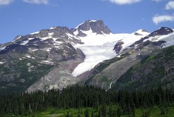
Mountain or alpine glaciers are the smallest type of glacier. These glaciers can range in size from a small mass of ice occupying a cirque to a much larger system filling a mountain valley (Figure 2). Some mountain glaciers are even found in the tropics. The merger of many alpine glaciers creates the third type of glacier, piedmont glaciers. Piedmont glaciers are between several thousand to several tens of thousands of square kilometers in size.
Glacial Processes
Growth of Glaciers

Ice that makes up glaciers originally fell on its surface as snow. To become ice, this snow underwent modifications that caused it to become more compact and dense. Glacial ice has a density of about 850 kilograms per cubic meter. The density of snow ranges from about 50 to 300 kilograms per cubic meter (the density of fresh water is approximately 1,000 kilograms per cubic meter). After the snow falls, the crystals can be reduced by the effects of melting and sublimation. Scientists call this process ablation. For most glaciers, ablation is a phenomena dominant in the summer months. The snow also undergoes physical compaction through melting and refreezing. At first, these processes cause the original snowflakes to be transformed into small round crystals. This partly melted, compressed snow is called névé. Névé has a density exceeding 500 kilograms per cubic meter. If the névé survives the ablation that occurs during the summer months it is called firn. When this process happens year after year, a number of layers of firn can accumulate. Accumulation then causes a further increase in density, modifying the firn into glacier ice, as the lower layers of firn are compressed by the weight of the layers above. On average, the transformation of névé into glacial ice may take 25 to 100 years.
Glacier Movement

To be called a glacier, a mass of ice must be capable of motion. Glacial movement occurs when the growing ice mass becomes too heavy to maintain its rigid shape and begins to flow by plastic deformation. In most mountain glaciers, flow of ice begins with accumulations of snow and ice greater than 20 [[meter]s].
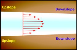
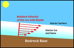
Flow rates within the various regions of a glacier are not uniform. From directly above, the middle of the glacier appears to flow with the greatest speed (Figure 4). At the margins of glaciers, surface movement is slowed down because of the frictional effects of the valley wall. Looking at the glacier in cross-section, we notice that the bottom of the glacier also moves slowly, once again, because of the influence of frictional forces (Figure 5).

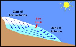
Figure 6 illustrates the typical pattern of ice flow in a valley glacier. In the upper reaches of the glacier, ice and snow accumulate in a broad basin formed by the effects of physical weathering and erosion. As the glacier proceeds to move downslope, the flow lines of the ice begin to converge because of the narrowing of the valley. This convergence causes a compression of the ice flow in central section of the glacier, and a resultant increase in velocity. At the terminal end of the glacier, flow lines spread out, and glacier speed is reduced.
The velocity of flow of glacier ice is influenced by a variety of factors. Some of the more important factors are the gradient of the valley floor, the temperature and thickness of the ice, and the constriction caused by the valley walls. The movement of ice over the ground in most temperate glaciers is enhanced by a process known as basal sliding. The immense pressure caused by the weight of the overlying glacial mass causes the ice making contact with the ground to melt because of pressure, despite subzero temperatures (pressure melting). The melting ice then forms a layer of water that reduces the friction between the glacial ice and the ground surface. This basal meltwater can be supplemented by surface meltwater reaching the glacier base. This water then facilitates the movement of the ice over the ground surface by producing a layer with very little friction. Because of basal sliding, some glaciers can move up to 50 meters in one day. However, average rates of movement are usually less than 1 meter per day. Cold glaciers are frozen to their bed and tend to move very slowly because there is no basal sliding, and cold ice is harder and deforms more slowly than warm ice. Movement in these glaciers takes place mainly due to internal deformation of the ice.
Glacier Mass Balance

Scientists often view glaciers as systems that are influenced by a number of inputs and outputs. The main inputs to the glacial system are water, in the form of snow, and eroded sediments that are picked up by the moving ice. Water leaves the glacial system when ice is converted into water or vapor. Sediment is deposited at the base of the glacier as till and at its terminal end as moraines or materials reworked by glaciofluvial processes.
We can also use a systems approach to help us understand why glaciers expand and shrink, and advance and retreat. Glaciers advance and retreat in response to changes in mass balance. The mass balance of a glacier involves two main components: accumulation of snow in the glacier's zone of accumulation and the ablation of ice in the zone of ablation (Figure 7). The zone of accumulation occurs in the upper reaches of the glacier where yearly additions of snow exceed losses due to melting, evaporation, and sublimation. The surface of this zone is covered by snow throughout the year. Below the zone of accumulation is the zone of ablation. In this zone, the losses of snow and ice from melting, evaporation, and sublimation are greater than the additions. The line that separates these two areas is called the firn limit or snow line.
Figure 7 illustrates the major components of glacier mass balance. Additions to the glacial system occur in the zone of accumulation where snow is converted into glacial ice over time. This ice then flows downslope into the zone of ablation. In the zone of ablation, losses occur from the glacier from the melting, evaporation, and sublimation of solid and liquid forms of water.

Forward flow of glacial ice is controlled by gravity and the accumulation of snow in the zone of accumulation. If losses due to ablation are identical to accumulation, the glacier will appear to be standing still in spite of the fact that the ice is actually moving forward. Melting at the terminus merely equals the forward motion of the glacier.
If a climate change occurs that increases the mass balance the glacier will advance, in an attempt to reach a new equilibrium position. The surplus of accumulation that exists must be balanced by an increase in ablation, which is accomplished by expanding the low-elevation terminus zone of the ablation area. If a climate change occurs reducing mass balance the glacier will retreat in an attempt to achieve equilibrium. The retreat will reduce the area of the glacier in the lowest elevation terminus area where ablation is highest. If by retreat mass balance equilibrium is reached the glacier will cease retreating. If the glacier cannot acheive equilibrium via retreat, it is in disequilibrium and will disappear.
Ideally, the rate of flow and movement of the glacier's terminus should be controlled by net accumulation and net ablation. This relationship, however, is not temporally immediate. In many glaciers, there are significant time lags between one year's net accumulation and net ablation and the corresponding movement of the glacier. This response time ranges from a few years on smaller alpine glaciers to several decades on large alpine glaciers and centuries for ice sheets.
Eventually, all glacier ice is lost in the zone of ablation by the processes of melting, evaporation, and sublimation and calving. This process occurs when a glacier terminates in a body of water of sufficient depth to generate calving. Calving involves the separation of portions of the glacier ice into the water body. Many icebergs enter the oceans of the world from the calving of the Greenland and Antarctic glaciers. Glaciers that calve icebergs tend to retreat more rapidly as this process allows for rapid mass loss, than land terminating glaciers.
Today most glaciers are retreating because of the general warming of global temperatures since the beginning of this century (Figure 8). This indicates that the mass balances of these glaciers are negative because of less snow accumulating or higher levels of ablation. During the Little Ice Age, when global temperatures were cooler than present, many glaciers over much of the world made strong advances. Glaciers offer a potentially important negative feedback loop in any global warming trend, since glacial melt increases albedo, thus reducing reflective solar, and promoting a global cooling effect.
See Also
References
- Physical Geography PhysicalGeography.net
- Goode, P.R., J. Qiu, V. Yurchyshyn, J. Hickey, M.?C. Chu, E. Kolbe, C. T. Brown, and S. E. Koonin. 2001. Earthshine Observations of the Earth’s Reflectance. Geophysical Research Letters 28 (9): 1671–1674.
- Jansen, E., J. Overpeck, K.R. Briffa, J.-C. Duplessy, F. Joos, V. Masson-Delmotte, D. Olago, B. Otto-Bliesner, W.R. Peltier, S. Rahmstorf,R. Ramesh, D. Raynaud, D. Rind, O. Solomina, R. Villalba and D. Zhang, 2007: Palaeoclimate. In: Climate Change 2007: The Physical Science Basis. Contribution of Working Group I to the Fourth Assessment Report of the Intergovernmental Panel on Climate Change [Solomon, S., D. Qin, M. Manning, Z. Chen, M. Marquis, K.B. Averyt, M. Tignor and H.L. Miller (eds.)]. Cambridge University Press,Cambridge, United Kingdom and New York, NY, USA
- Marco Tedesco and Andrew J. Monaghan, "An updated Antarctic melt record through 2009 and its linkages to high-latitude and tropical climate variability," Geophys. Res. Lett. 36, L18502 (2009).
- Ruddiman, W.F. 2008. Earth's Climate: Past and Future. Second Edition. W.H. Freeman and Company, New York.

