Ecoregions of Bolivia
Ecoregions of Countries Collection 
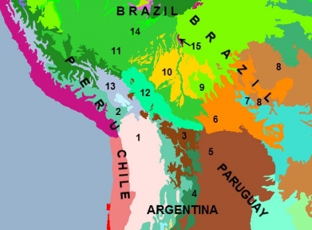
Bolivia includes fifteen ecoregions: [1] Central Andean dry puna; [2] Central Andean puna; [3] Bolivian montane dry forest; [4] Southern Andean Yungas; [5] Dry Chaco; [6] Chiquitano dry forests; [7] Pantanal; [8] Cerrado; [9] Madeira-Tapajós moist forests; [10] Beni savanna; [11] Southwest Amazon moist forests; [12] Bolivian Yungas; [13] Central Andean wet puna; [14] Iquitos varzea; [15] Monte Alegre varzea
Contents
- 1 Central Andean dry puna
- 2 Central Andean puna
- 3 Bolivian montane dry forest
- 4 Southern Andean Yungas
- 5 Dry Chaco
- 6 Chiquitano dry forests
- 7 Pantanal
- 8 Cerrado
- 9 Madeira-Tapajós moist forests
- 10 Beni savanna
- 11 Southwest Amazon moist forests
- 12 Bolivian Yungas
- 13 Central Andean wet puna
- 14 Iquitos varzea
- 15 Monte Alegre varzea
- 16 Context
Central Andean dry puna
This ecoregion is a very dry, high elevation montane grassland and herbaceous community of the southern high Andes, extending through western Bolivia and northern Chile and Argentina. The vegetation is characteristically tropical alpine herbs with dwarf shrubs, and occurs above 3,500 meters (m) between the tree-line and the permanent snow-line. Dry puna is distinguished from other types of puna by its annual rainfall, or lack of rainfall. This ecoregion receives less than 400 millimeters (mm) of rainfall each year, and is very seasonal with an eight-month long dry season. The Central Andean Dry Puna is a unique ecoregion with flora and fauna highly adapted to the extreme temperatures and altitudes. The region contains forests of Polylepis, the only arborescent genus that occurs naturally at high elevations. Various species of Andean camelids are also found in this region.
The Andean puna has been highly affected by livestock grazing for centuries. The natural vegetation has been severely affected by grazing, burning, firewood collection, and clearance for cultivation. The camelids, goats and sheep in the area degrade the herbaceous vegetation, making the life cycle for the plants difficult to complete. The clearing of Polylepis forest for agriculture, firewood collection, and burning for pasture is an important threat to the endemic fauna, especially birds.
There are some protected areas within this ecoregion; most of them were created as faunal reserves. Eduardo Avaroa Andean Faunal National Reserve in the southwest corner of Bolivia (IUCN category IV) of 714,745 hectares (ha), is an area principally for the protection of birds that inhabit the different lagoons in the Reserve. Several censuses of the flamingo population in this reserve registered 26,600 individuals. Sajama National Park in western Bolivia (IUCN category II) of 100,230 ha, is one of the most diverse Andean Parks in the ecoregion with 25 species of mammals registered. This park includes a forest of Polylepis with trees up to 5-meters high.
Central Andean puna
This ecoregion is a high elevation montane grassland in the southern high Andes, extending from southern Peru, though Bolivia, into northern Argentina. Open meadows are dotted with an assortment of rock, bunchgrass, herbs, moss, and lichens. This ecoregion is continuous and transitional between the wet puna to the north and west, and the dry puna to the south. The landscape is characteristically mountainous, with snow capped peaks, mountain pastures, high lakes, plateaus, and valleys.
This ecoregion faces increasing mining activity that is leading to the destruction of its scarce plant cover as well as the contamination of some bodies of water and the soil. In addition, this region has a large number of population centers and highways that cross the Andes, leading to a decline in natural habitat and growing pressures on the existing fauna.
Bolivian montane dry forest
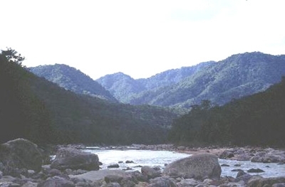 Photograph by WWF/ Liselotte Methfessel This ecoregion is restricted to south-central Bolivia, barely touching northwest Argentina. It is quite restricted, forming a transition between the Yungas and Puna zones in Bolivia. This dry region is characterized by steep hillsides, cliffs, and valleys and contains a number of endemic species of avifauna including the Bolivian recurvebill and Bolivian blackbird. A number of national parks protect a significant area of habitat, however more are needed in order to preserve this region heavily affected by urban expansion.
The extent of deforestation in this region has not been documented with certainty, but there are apparently large areas of degraded land.
There are a number of National Parks (NPs) and protected areas in this ecoregion, including: Tariquía National Reserve (2469 kilometers squared) and the slightly smaller Cama Valley Biological Reserve and Toro Toro NP. However, these three sites combined probably do not exceed 6000 km2 and more reserves within this region would be ideal.
Southern Andean Yungas
The Southern Andean Yungas are loosely bordered to the east by the Chaco, and tightly interdigitated to the west with Bolivian Montane Dry Forest, spanning southwestern Bolivia and northwestern Argentina. This ecoregion is extremely fascinating from a biogeographic perspective, as it contains what may be the last of the isolated ‘evergreen’ forests resulting from Quaternary glaciations. This region is rich in fauna species, especially avifauna. Many tropical species meet their southern limits of geographic distribution in this region. The forests of Argentina have suffered more damage than Bolivia. A number of national parks protect the forest of this ecoregion including Tariquía National Reserve (2469 km2 in Boloivia.
The extent of deforestation in Bolivia has not been documented with certainty, but there are large areas of degraded land. However, some large and intact [[region]s] still persist in Bolivia, such as the forests between the Pilcomayo and Pilaya rivers in Montes Chapeados that span ~1300 km2.
Dry Chaco
The Chaco ecoregion as defined herein is generally restricted to the northwestern two-thirds of western Paraguay, and east of the Andes in southeastern Bolivia and northwestern Argentina. The Guarani Indians initially described this region as "Gran Chaco", which implies productive hunting grounds. Today much of the northern Chaco is still abundant with large game mammals, suggesting sustainably harvested populations. However, this is no longer the case in much of the southern Chaco where rampant overgrazing and human population growth has preceded the pristine nature of the Chaco. An important migration route, many species of avifauna can be found in this ecoregion throughout the year. More protected areas are needed in order to save this habitat from overwhelming agricultural development.
The relatively newly established Parque Nacional (PN) Kaa-Iya, in Bolivia, sits abreast the [[Paraguay]an] border, relatively close to PN Defensores del Chaco.
Much of the Chaco is in various stages of alteration due to grazing of cattle and goats, the latter especially in the southern Chaco. This development is perhaps least severe around the border of the [[Paraguay]an] and [[Bolivia]n] Chaco, and most extensive in the Argentinean Chaco. Paved road development projects provide easy access to remote sites to hunt game and alter pristine wilderness for agrarian development. A good example of this is the Trans-Chaco highway that connects Paraguay and Bolivia (completed in late 1990s).
Chiquitano dry forests
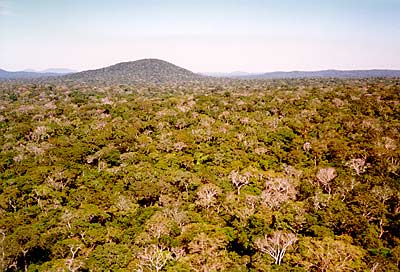 Department of Santa Cruz, Bolivia Photograph by John Morrison Roughly in the center of the South American continent, most of the Chiquitano forest lies within the eastern lowlands of Santa Cruz, Bolivia, with smaller patches extending into western Mato Grosso, Brazil. This ecoregion is not only a dry forest but a transition zone between the moist Amazonian forests of the north and these dryer forest of the southern Chaco [[region]s]. This forest takes its name from the indigenous groups, Chiquitanos, which inhabited them at the time of European colonization. It provided the scenario for most of the Jesuit missionary work during the 17th and 18th century.
This is the largest patch of healthy dry forest ecosystem alive today, and one of the most biologically diverse dry forests in the world. Two large blocks of forest in outstanding conservation condition, comprising 20% of the original ecoregion, remain. Both blocks lie east of San Jose de Chiquitos, split into a north and a south block by a road with ranches along it. Two protected areas Otuquis and San Matias, include important parts of this remnant forest, but linkages between them and effective management are urgent. The Tucavaca Valley is the middle area which needs to be put under protection to provide long-term ecological viability.
Pantanal
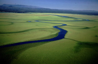 Rio Pimiento, Bolivia Photograph by Steffen Reichle/WWF-Bolivia Located roughly in the center of South America, near the borders of Brazil, Bolivia, and Paraguay, the Pantanal stretches from 16° to 20° S latitude. The majority of the ecoregion occurs in Brazil as a floodplain around the Rio Paraguay and tributaries. The terrain is essentially flat, ranging from 75 to 200 meters (m) above sea level. This elevation coupled with the gentle slope of the rivers in the area, account for the massive flooding during the annual wet season when up to 78% of the area can be submerged.
The Pantanal is the largest wetland in South America, and the largest wetland in the world that has not been substantially modified by humans. While endemism in the area is low, the sheer abundance of large birds, reptiles, and mammals mark its importance as a huge reservoir of biodiversity. Much of the ecoregion remains intact; however, pesticide runoff constitutes a major threat to the watershed of the Rio Paraguay. Also, a project by several governments plans to provide navigable waterway for shipping and dams for hydroelectricity generation, which would drastically alter this pristine habitat.
While cattle ranching is not intense, this type of land use causes some degree of habitat modification. The majority of the Pantanal is in close to pristine condition with most of its biota still extant. Only two dirt roads cross the area from the northern end near Cuiabá, and one road bisects the area between Campo Grande and Corumbá. Less than 3% of the Pantanal is currently included in protected areas; the remainder of the land is privately owned. The Pantanal National Park covers 1,370 square kilometers (km2) area along the Rio Paraguay, but unfortunately it is dominated by areas completely inundated during the wet season and protects little savanna or forest habitat.
Cerrado
Cerrado is the largest savanna region in South America and biologically the richest savanna in all the world. It encompasses Central Brazil (most of Mato Grosso, Mato Grosso do Sul, and Tocantins; western Minas Gerais and Bahia; southern Maranhão and Piauí; all Goiás and Distrito Federal; and small portions of São Paulo and Paraná), northeastern Paraguay and eastern Bolivia. Because of its central position in South America, Cerrado has borders with the largest South American biomes: the Amazon basin (on north), Chaco and Pantanal (on west), Caatinga (on northeast), and Atlantic forest (on east and south).
This ecoregion also contains an amazing about of biodiversity, over 10,400 species of vascular plants are found, fifty of which are endemic. Fauna diversity is very high also with 180 species of reptiles, 113 of amphibians, 837 of birds and 195 of mammals. Major efforts are needed to preserve what is one of the biologically richest savanna in the world, since only one percent of this ecoregion is protected and agriculture development continues to destroy habitat.
Around 67 percent of the Cerrado ecoregion has been already either completely converted or modified in a major way. In contrast, only 1 percent of the total area of the Cerrado Region is protected in parks or reserves. Most of the large-scale human modification in the Cerrado took place in the last 50 years.
Madeira-Tapajós moist forests
The Madeira-Tapajós moist forest ecoregion lies in central Amazonia in Brazil south of the Amazon River. It spans the lowland Amazon Basin reaching south to the border with Bolivia. It encompasses portions of three Brazilian states (Amazonas, Rondônia, Mato Grosso) and part of the Bolivian Department of Beni.
This ecoregion is bound on three sides by large rivers, the Solimões (Amazon) to the north, Madeira to the west, and Tapajós to the east, which act as formidable barrier to the distributions of many species.The region includes the large interfluve between the Madeira and Tapajós Rivers, both major tributaries to the mighty Amazon, and extends southward into the headwaters of the Tapajós to the Rio Guaporé Basin. The region encompasses a variety of vegetation types including dense lowland rain forest, dense submontane rain forest, open-canopy submontane rain forest, and woodland savanna.
This region hosts one of the most degraded environments of central Amazonia.
Beni savanna
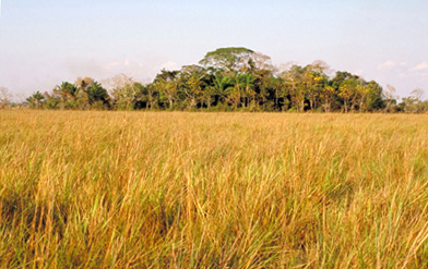 Beni Biological Station, Bolivia. (Photograph by Jon Hornbuckle) The Beni savannas are located in the lowlands of the southwestern Amazon Basin, extending northeastward from the foot of the Andean ranges. Almost all of the ecoregion lies within Bolivia in the departments of El Beni, Cochabamba, La Paz, Pando, and Santa Cruz, with small areas along the Iténez (Guaporé) River in the [[Brazil]ian] State of Rondonia and in the Pampas del Heath of the Madre de Dios Department of Peru.
The Beni savannas, also known as the Moxos plains, are the third largest complexes of savannas in South America. This ecoregion has been identified as a plant diversity and endemic center. The abundance of fauna and flora, including threatened species, makes this region highly valuable.
Since the arrival of the Jesuits in the 1680s, the predominant land use of the Llanos de Moxos ecoregion has been cattle ranching on the savannas and wetlands. Anthropogenic fire is used to remove low quality biomass and stimulate regrowth at the end of the dry season. Consequently, few areas remain in their pre-European state. Some forest islands are actually remaining fragments from a previously larger forest stand reduced by human activities; however, historical deforestation in the Moxos region has not yet approached the extent in neighboring [[region]s].
Beni savannas and wetland areas are poorly represented in [[Bolivia]'s] protected areas system. The Alto Madidi National Park contains areas of these savannas in the north of the La Paz Department. The Manuripi-Heath National Amazonian Reserve of La Paz and Pando contains small islands of savanna. The Beni Biological Station is a UNESCO Biosphere Reserve located in the southwest of this region. It includes 1,350 km2 of flat lowlands, but with little savanna. The Iténez Fiscal Reserve of 15,000 km2 is located on the eastern extreme, but only partially in the Llanos de Moxos ecoregion. Timber extraction is the main activity in this reserve. A national park has been proposed for the savannas and Mauritia palm swamps to the south of the Iténez Fiscal Reserve. A large portion of the southern savannas and wetlands are located with the Multi-ethnic Indigenous Territory and the Isiboro-Sécure Indigenous Territory/National Park. Land tenure and management issues in these territories, however, remain uncertain. The Sirionó Indigenous Territory occupies a portion of the forest-savanna mosaic approximately 60 km east of the Mamoré River. The Ríos Blanco and Negro Wildlife Reserve in Santa Cruz contains a portions of the southern Baures savannas and wetlands.
Southwest Amazon moist forests
This ecoregion located in the Upper Amazon Basin, is characterized by a relatively flat landscape with alluvial plains dissected by undulating hills or high terraces.
The biota of the southwest Amazon moist forest is very rich because of these dramatic edaphic and topographical variations at both the local and regional levels.
This ecoregion has the highest number of both mammals and birds recorded for the Amazonian biogeographic realm: 257 with 11 endemics for mammals and 782 and 17 endemics for birds. The inaccessibility of this region, along with few roads, has kept most of the habitat intact. Also, there are a number of protected areas, which preserve this extremely biologically rich ecoregion.
The Manuripi Heath National Reserve is located in the southernmost area of this region in Bolivia covering 18,900 km2 of dense tropical forest.
Much of the natural habitat of the region remains intact, protected by sheer inaccessibility. People have dwelled along the major rivers for millennia and have subtly altered the forests on a small scale, but around the urban centers development proceeds.
Bolivian Yungas
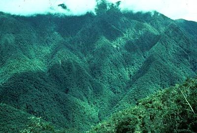 Photograph by Gary Hartshorn The Bolivian Yungas are restricted to west-central Bolivia and extreme southeastern Peru. The northern, southern, western and eastern boundaries of this ecoregion terminate approximately at the 13° and 17° south latitudes and 69° and 63° west longitudes, respectively.
This ecoregion forms a transition along Andean slope between Amazonian and highland Puna habitat. Habitats range from montane forest and cloud forest, to lowland forest. The high levels of biodiversity and endemism characterizing this unique ecoregion are attributable to its transitional position between highly contrasting [[habitat]s], as well as extremely heterogeneic topography. Rare fauna species are present such as the spectacled bear, Geoffroy’s cat, and green-capped tanager. Much of this region is under the protection of national parks, however slash and burn practices threaten most of the unprotected habitat.
Fortunately, most protected areas in this ecoregion are difficult to cultivate due to difficult access, steepness of terrain, and very high rainfall. There are a number of relatively large protected areas covering this ecoregion. In Bolivia are Maididi National Park 19,000 km2, Carrasco National Park – 13,000 km2, Isiboror Sécure National Park – 11,000 km2, Amboro National Park - 1800 km2, and Bellavista Protection Forest Reserve – 900 km2 which equate to over 60,000 km2 of protected area. The distribution of these protected areas within the Yungas is fairly well covered in light of petroleum concessions and habitat alteration.
Central Andean wet puna
This ecoregion is a high elevation, wet, montane grassland in the southern high Andes, occurring from northern Peru to eastern Bolivia. Occurring above tree-line, that is to say above approximately 3,500 meters (m) elevation, this regions is composed of bunchgrass communities, wetlands, small shrubs, and trees, and herbaceous plants. The wet puna is bordered on the west by the dry Sechura desert and to the east by the wet Peruvian Yungas, which makes for extreme transitional zones. The landscape is characteristically mountainous, with snow capped peaks, mountain pastures, high lakes, plateaus, and valleys.
In Bolivia, the ecoregion is found in the south of the department of La Paz. The Andes divides into two mountain systems- Cordillera Occidental and the Cordillera Oriental- close to the border of Peru and Bolivia. The Cordillera Oriental is in turn divided into two Cordilleras, the Real and the Central. The Cordillera Real contains various mountain chains, among which are the Cordillera de Apolobamba, Cordillera de Muñecas, Cordillera de La Paz, and Cordillera de Tres Cruces.
The ecoregion contains snow-capped peaks, glacial lakes, and several rivers that originate in the Cordilleras. The biggest lake in the ecoregion is Lake Titicaca, which is the highest lake in the world, at an elevation of 3,800 m.a.s.l. Its main tributaries in Bolivia are the Suches and Tiwanacu rivers.
National Faunal Reserve Ulla-Ulla (IUCN category IV, 150,000 ha) is located on the border of Peru and Bolivia. Ulla-Ulla is a biosphere reserve that protects various animals. The most important is the vicuña (Vicugna vicugna), which has been protected since 1965. The Vicuña population declined significantly due to hunting to get the fine wool fiber, but it has recovered in the past decade. The population of the vicuñas in 1996 was of 6,500 individuals.
Iquitos varzea
This ecoregion comprises the low, seasonally inundated river basins of the upper Amazon, Ucayali, Marañon, and Madre de Dios, in Peru and Bolivia, several smaller tributaries to the Amazon in Peru, and the upper Juruá and Purus Rivers in Brazil. A large portion of the region centers around the extensive seasonally flooded plain in northeastern Peru at the confluence of the Marañon and Ucayali Rivers that join to form the Amazon. The Rivers Pacaya and Simiria bisect this plain. The large urban center of Iquitos lies at 100 meters (m) elevation, and the topography, on the whole, is very flat with micro-undulations resulting from river meander.
The várzea, because it lies along water "highways," is a region much affected by human activities, both historically and in the present. Today much of the várzea is used for agriculture and managed forest by smallholder farmers, but their systems tend to be biologically diverse agroecosystems. Hence, much of the forest is managed or unmanaged secondary forest. Nevertheless, this region suffers a high degree of deforestation.
Monte Alegre varzea
This ecoregion in Brazil comprises portions of the low, seasonally inundated river basins of the central and lower Amazon, much of the length of the Madeira River Basin, and the mouth of the Purus River where it joins the Solimões (Amazon), as well as several smaller tributaries to these. An isolated patch occurs on the border of Brazil and Bolivia along the Mamoré River.
Biodiversity is extremely high in this flooded forest along the lower Amazon. The region hosts an amazing number of avifauna; there are 681 reported bird species including red-shouldered macaws (Ara nobilis), sun parakeets (Aratinga solstitialis), and green-rumped parrotlets (Forpus passerinus). Over two hundred species of mammals are found here including jaguars (Panthera onca), ocelots (Leopardus pardalis), tapirs (Tapirus terrestris), and a number of primate species. There are few protected areas in this ecoregion, which is threatened by cattle ranching and large scale agriculture.
Context
Ecoregions are areas that:
[1] share a large majority of their species and ecological dynamics;
[2] share similar environmental conditions; and,
[3] interact ecologically in ways that are critical for their long-term persistence.

