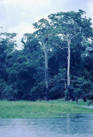
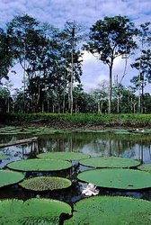
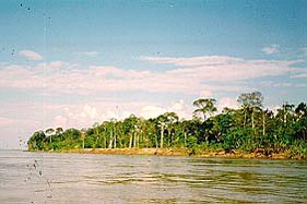
Iquitos varzea
This ecoregion comprises the low, seasonally inundated river basins of the upper Amazon, Ucayali, Marañon, and Madre de Dios, in Peru and Bolivia, several smaller tributaries to the Amazon in Peru, and the upper Juruá and Purus Rivers in Brazil. A large portion of the region centers around the extensive seasonally flooded plain in northeastern Peru at the confluence of the Marañon and Ucayali Rivers that join to form the Amazon. The Rivers Pacaya and Simiria bisect this plain. The large urban center of Iquitos lies at 100 meters (m) elevation, and the topography, on the whole, is very flat with micro-undulations resulting from river meander.
Location and General Description
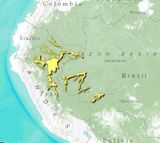
The term várzea refers to land that is inundated by overflow from whitewater [[river]s] . The substrate of the várzea is composed of alluvial and fluvial Holocene sediments (less than 10,000 years old) loosed from the eastern slopes of the Andes Mountains. Both the geomorphology and biogeography of this region are influenced by very active fluvial dynamics. At Iquitos, the Amazon River floods twice a year as the rivers from the Peruvian Andes and then the Ecuadorian Andes swell and then exceed their banks after dramatic amounts of seasonal rainfall in these watersheds. The river water, heavily laden with sediments and thus called whitewater, floods the surrounding forest under 6 to 7 m for periods up to ten months each year, affecting a swath of land up to 20 kilometers (km) wide. The deposition of the nutrient-rich suspended solids in these whitewater rivers replenishes the mineral nutrients across the várzea, rendering the ground remarkably fertile, a trait unequaled on the adjacent Amazon uplands.
Over time (from decades to millennia) these river courses meander across the floodplain, resulting in ever-changing geomorphology and heterogeneous landscape with a diversity of elements such as oxbow lakes, levees, meander swales, and point bars. Lateral erosion and deposition on the riverbanks occur with every flood, resulting in a vast number of ephemeral fluvial islands and extensive bands of primary successional forest. The dynamic geomorphology is reflected in the diversity of vegetation types. Annual precipitation in this region ranges from 2,400 to 3,000 millimeters (mm), and the average annual temperature is 26°C, with little seasonal variation.
The forests comprise a mosaic of habitats because of the heterogeneity in landforms. Topographic differences of only meters yield dramatic changes in species composition. Four vegetation types are defined and are delimited by the present and historical influence of the flood cycle. Three are on floodplain meanders, all resulting from the instability of the river courses: (1) sequences of successional vegetation, (2) forest mosaics, and (3) aquatic vegetation in poorly drained areas. The fourth type is permanent swamp vegetation in flooded river basins . These forests host combinations of terrestrial and aquatic components which dominate during different seasons of the year. For instance, trees and aquatic herbaceous vegetation rest on the ground during the low water season. The várzea forest performs critical ecological functions such as capturing and rapidly cycling nutrients, hosting a great diversity of freshwater fish and aquatic mammals, stabilizing the flooded soils and landscapes, and perhaps providing a source of new taxa that colonize the surrounding terra firme.
The region is characterized by an evergreen tropical forest with a complex and heterogeneous vertical structure. Because of the river action, these forests are found in numerous seral stages and with topographically or edaphically distinct floristics. The youngest vegetation is dominated by the grasses Gynerium sagittatum, Paspalum repens, and Echinocloa polystachya. This is followed by woody shrubs, such as Adenaria floribunda, Alchornea castanaefolia, and Salix martiana, then by early successional trees, such as Annona hypoglauca, Astrocaryum jauari, and Cecropia latiloba. Late successional forests, characterized by the tree genera Chorisia, Eschweilera, Hura, Spondias, and Virola, are found on ancient alluvial terraces.
Extensive stands of the economically important buriti palm (Mauritia flexuosa) and Jessenia batuaua are characteristic in this region as well in permanently inundated areas. The waters edge is sometimes dominated by shrubs of the camu-camu fruit (Myrciaria dubia) that not only survive the long flood season, but seem to flourish. A strong component of monocots in the Heliconiaceae, Zingiberaceae, and Marantaceae dominate parts of the understory, along with palms and epiphytes. Trees that stand out in mature várzea forests are Calycophyllum spruceanum, Ceiba samauma, Inga sp., Cedrela oderata, Copaifera reticulata, and Phytelephas macrocarpa. Palms such as Sheelea and Guazuma rosea, of subandine origin, are common on the Upper Purus, and Piptadenia pteroclada is common along the Amazon. Stands characterized by Parkia inundabilis, Septotheca tessmannii, Coumarouna micrantha, Ceiba burchellii, Ochroma lagopus, Manilkara inundata, and Iryanthera tessmannii are abundant near Iquitos.
Biodiversity Features
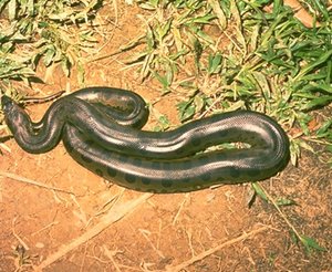 Anaconda (Eunectes murinu), near the borders of Peru, Brazil and Columbia (Photograph by Dr. Lloyd Glenn Ingles, California Academy of Sciences & CalPhotos)
 Some of the flora and fauna of the várzea is restricted to these seasonally flooded habitats and is distinctive from the adjacent upland forest. While the alpha-diversity of the flooded forests tends to be lower than the upland evergreen moist forests, the flooded forests tend toward a higher beta-diversity because of landform heterogeneity. However, here in the Upper Amazon region, the delineation of várzea and terra firme forest is less distinct than on the lower várzea, rendering these várzeas slightly richer than those on the central and lower Amazon .
The Iquitos várzea ecoregion as a whole claims 227 species of mammals and 624 species of birds. There is a high density of felids, and the following are common terrestrial mammals: jaguars (Panthera onca), ocelots (Leopardus pardalis), tapirs (Tapirus terrestris), capybaras (Hydrochaeris hydrochaeris), kinkajous (Potos flavus), and white-lipped peccaries (Tayassu pecari). Large reptiles in the area include black caimans (Melanosuchus niger), endangered yellow-headed sideneck turtles (Podocnemis unifilis), and anacondas (Eunectes murinus). The endangered giant otter (Pteronura brasiliensis), endemic to South America, is found in these [[river]s]. The region of Iquitos is home to 88 species of snakes and 30 species of lizards. Primates that live in young floodplain forests include various species of spider monkeys (Ateles spp.), two capuchins (Cebus albifrons, C. apuella), red howler monkeys (Alouatta seniculus), squirrel monkeys (Saimiri sciureus), and the endangered red uakari monkeys (Cacajao calvus) in swamp forests. Amazon bamboo rats (Dactylomys dactylinus) and various species of arboreal spiney rats (Echimys spp.) are found in the floodplain forests in upper Amazonia.
Aquatic mammals include the Amazon River dolphins (Inia geoffrensis, pink, and Sotalia fluviatilis, grey) and vulnerable manatees (Trichechus inunguis). Mammals that occur in the Iquitos várzea and few other regions include four species of opossums (Caluromysiops irrupta, Marmosa lepida and M. rubra, Monodelphis adusta), some bats (Anoura geoffroyi, Sturnira bogotensis), Goeldi’s marmosets (Callimico goeldii), Andean night monkeys (Aotus miconax), monk sakis (Pithecia aequatorialis), and spiney rats (Proechimys quadruplicatus).
Very large fish live in these whitewater rivers, and during the flood season they roam through the flooded forest eating and dispersing fruits from the floodplain trees. These fish include the pacu (Metynnis and Mylossoma), tambaqui (Colossoma macropomum), pirarucu (Arapaima gigas), sardinha (Triportheus angulatus), and the smaller pirana (Serrasalmus spp.), a carnivorous characin. Many beautiful aquarium fish come from these rivers and blackwater tributaries and lakes in this region. These include the angelfish (Pterophyllum scalare), the discus fish (Symphsodon aequifasciata sp.), hundreds of cichlids such as in the genus Cichlasoma, assorted characins (family Anostomidae) such as tetras in the genera Hemigrammus and Hyphessobrycon and the famous neon tetra (Paracheirodon innesi), and many small catfish (families Aspredinidae, Corydoradinae, Doradidae, and Loricariidae).
Current Status
The várzea, because it lies along water "highways," is a region much affected by human activities, both historically and in the present. Today much of the várzea is used for agriculture and managed forest by smallholder farmers, but their systems tend to be biologically diverse agroecosystems. Hence, much of the forest is managed or unmanaged secondary forest. Nevertheless, this region suffers a high degree of deforestation. The Pacaya-Simiria National Reserve near Iquitos covers more than 20,000 square kilometers (km2) of this very complex, dynamic and heterogeneous area. This region is important for biological and ecological studies as well as conservation activities. The Tambopata Biological Station also protects a small area of várzea in Peru. The várzea forest is critical habitat for reproductive and nursery grounds for fishes and many invertebrates.
Types and Severity of Threats
Anthropogenic-induced habitat loss (Land-use and land-cover change) is the main threat to the flora and fauna in this region. Contamination of [[river]s] and fish by gold mining activities, and heavy sedimentation resulting from forest destruction, such as logging, threaten the várzea biota and habitat. Mahogany (Swietenia macrophylla) and several other timber species have been locally eliminated in some areas, along with tapir and several primates. Commercial fishing and river contamination threatens populations of some fish and aquatic mammals. Ranchers clear and burn large patches of floodplain forests to encourage native grasses for livestock grazing, and in the process destroy important habitat and food for fish.
Justification of Ecoregion Delineation
This seasonally flooded ecoregion was delineated according to the presence of ancient crystalline arches which distinguish these várzea ecoregions based on tectonic basement rock composition. Linework for the eastern portion is approximated according to the presence the Iquitos arch, and western boundary demarcates the upper reaches of this habitat in the Amazon Basin. Linework differs from other várzea ecoregions, in that LandSat TM 5 imagery (at a scale of 1:250,000) was used to delineate these riparian habitats in Peru – and [[Brazil]ian] portions follow IBGE classifications of "alluvial open ombrophilous forests" and "alluvial dense ombrophilous forests". The importance of these arches in distinguishing várzea ecoregions is discussed by da Silva.
Additional Information on this Ecoregion
- For a shorter summary of this entry, see the WWF WildWorld profile of this ecoregion.
- To see the species that live in this ecoregion, including images and threat levels, see the WWF Wildfinder description of this ecoregion.
- World Wildlife Fund Homepage
Further Reading
- Daly, D. C., and J. D. Mitchell. 2000. Lowland vegetation of tropical South America. Pages 391-453 in D. L. Lentz, editor, Imperfect balance: Landscape transformations in the Precolumbian Americas. New York: Columbia University Press.
- Daly, D.C., and G.T. Prance. 1989. Brazilian Amazon. Pages 401-426 in D.G. Campbell, and H.D. Hammond, editors. Floristic inventory of tropical countries. New York Botanical Garden, Bronx, New York, USA. ISBN: 0893273333
- Etter, A. 1998. Mapa General de Ecosistemas de Colombia. Escala 1:1,500,000. Instituto de Investigación de Recursos Biológicos Alexander von Humboldt. Santa fe de Bogotá.Fundação Instituto Brasilero de Geografia
- Estatástica-IBGE. 1993. Mapa de vegetação do Brasil. Map 1:5,000,000. Rio de Janeiro, Brazil.
- Ducke, A., and G.A. Black. 1953. Phytogeographical notes on the Brazilian Amazon. Anais da Academia Brasileira de Ciências 25: 1-46.
- Prance, G.T. 1979. Notes on the vegetation of Amazonia III. The terminology of Amazonian forest types subject to inundation. Brittonia 31: 26-38.
- Puhakka, M., and R. Kalliola. 1993. La vegatación en areas de inundación en la selva baja de la Amazonia Peruana. Pages 111-138 in R. Kalliola, M. Puhakka, and W. Danjoy, editors, Amazonia Peruana: vegetación húmeda tropical en el llano subandino. Turku: PAUT and ONERN.
- Rizzini, C. T. 1963. Nota prévia sôbre a divisão fitogeográfica do Brasil. Revista Brasileria de Geografia 1: 1-64.
- Silva, J.M. C. 1998. Um método para o estabelecimento de áreas prioritárias para a conservação na Amazônia Legal. Report prepared for WWF-Brazil. 17 pp.
| Disclaimer: This article is taken wholly from, or contains information that was originally published by, the World Wildlife Fund. Topic editors and authors for the Encyclopedia of Earth may have edited its content or added new information. The use of information from the World Wildlife Fund should not be construed as support for or endorsement by that organization for any new information added by EoE personnel, or for any editing of the original content. |
