Central Andean puna
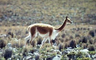
Vicuña, Pampa Galeras Barbara D'Achille, Peru. Photograph by © WWF-Canon/Y.-J. Rey-Millet
This ecoregion is a high elevation montane grassland in the southern high Andes, extending from southern Peru, though Bolivia, into northern Argentina. Open meadows are dotted with an assortment of rock, bunchgrass, herbs, moss, and lichens. This ecoregion is continuous and transitional between the wet puna to the north and west, and the dry puna to the south. The landscape is characteristically mountainous, with snow capped peaks, mountain pastures, high lakes, plateaus, and valleys.
Location and General Description

The Central Andean Puna, despite its characteristic dryness and because it still maintains nearly unaltered blocks of habitat, represents an important area for theconservation of endemic species of both flora and fauna.
Located in South America in southwestern Peru and northwestern Bolivia, it occupies an area of 140,960 square kilometers (km2) and lies within the altitudinal range between 3,200 and 6,600 meters (m) above sea level. Its climate varies from temperate to cold, it is dry with an average temperature between <0 and 15ºC. Precipitation varies between 250 and 500 millimeters (mm) per year. This ecoregion rests on formations of volcanic origin subsequent to the formation of the Andes (about 6-8 million years ago). While the western range consists of sedimentary rocks from the Mesozoic and Cenozoic, the eastern range with various folds and faults consists of metamorphic rocks from the Paleozoic. There are also gray limestone and fossil deposits like those of Sicuani, from the marine incursion of the Jurassic, as well as diorites and granites of Andean batholiths from the Cretacean. Volcanic soils associated with soils of varied lithology are notable.
The vegetation is characterized by being notably drier than in the rest of the puna. It consists primarily of grasslands made up of different types of grasses primarily of the genera Calamagrostis, Agrostis and Festuca. There are also grasslands with wet formations like bofedales, peat bogs and some reed beds. Characteristic formations include the tolares, consisting primarily of tola (Parasthrephia lepidophylla), and the cangllares, dominated by the canglla (Margyricarpus sp.), both small bushy species. As in the wet puna, there are yaretales (Azorella yarita) and rodales of Puya raimondi, a species that has the largest spike in the world. There are also some relicts of montane forests of native species like the queñoa (Polylepis spp.) and colle (Buddleia sp.) and chachacomo (Escallonia sp.) trees can be found at lower altitudes.
Biodiversity Features
The characteristic aridity and limited oxygen associated with strong natural disturbances like droughts and frosts have generally limited the development of life but have favored the establishment of those species that have been able to adapt to these cold conditions where resources are scarce. Thus the species that inhabit the ecoregion have interesting adaptations like the shape of their leaves, very slow growth, stunted forms and high resin content. In the case of fauna, herbivores have strong incisors that allow them to feed on the hardest plants with silicon content and also have special skins or plumage (as applicable) that allow them to tolerate low [[temperature]s] and strong winds. Some of the endemisms in the ecoregion are the supu-tola (Diplostephium tovari) and the mullu-mullu (Ribes brachybotrys) in terms of vegetation; fauna include the suri (Pterocnemia pennata) and the Punomys lemminus (a rodent). The diversity of mammals, particularly rodents, is notable and increases going from north to south, evidence of a latitudinal effect produced by the various rivers that have acted as barriers to dispersion.
The most representative fauna in this ecoregion, although not exclusive, are vicuña (Vicugna vicugna), guanaco (Lama guanicoe), chinchilla (Chinchilla brevicaudata) and vizcacha (Lagidium sp.). Threatened bird species include Cinclodes aricomae, Conirostrum tamarugense, flamenco de James (Phoenicopterus jamesi), and gallareta gigante (Fulica gigantea).
Current Status
This ecoregion faces increasing mining activity that is leading to the destruction of its scarce plant cover as well as the contamination of some bodies of water and the soil. In addition, this region has a large number of population centers and highways that cross the Andes, leading to a decline in natural habitat and growing pressures on the existing fauna. Fortunately, a portion of these [[habitat]s] is represented within some existing protected natural areas and most plant formations are included in these areas. However, there are still some information gaps, particularly in the case of birds, and there are some priority areas to be preserved.
Justification of Ecoregion Delineation
This puna ecoregion of the central Andes is characterized by an intermediate climate and a number of endemic species. In Peru, our linework follows the Instituto Geográfico Nacional, however we distinguish this ecoregion from both wet and dry puna ecoregions based on the classifications scheme of UNESCO, from which we lumped "Andean caespitose herbaceous vegetation of varied coverage with dwarf shrubs (puna)"and "Andean degraded caespitose herrbaceous vegetation with dwarf shrubs". In Chile we also followed the aformentioned UNESCO classification scheme. In Bolivia our linework follows Ribera et al. who classifies this region as "semi-humid puna prairie". In Argentina we followed Daniele and Natenzon, who classify this region as "monte and thistles of the prepuna" for the eastern delineation, and UNESCO, following the same classification mentioned above. Reference was also made to Morello, and Carbrera.
Additional Information on this Ecoregion
- For a shorter summary of this entry, see the WWF WildWorld profile of this ecoregion
- To see the species that live in this ecoregion, including images and threat levels, see the WWF Wildfinder description of this ecoregion.
- World Wildlife Fund Homepage
Further Reading
- Bibby C, J., J. Collar , and M. Crosby. 1992. Putting biodiversity on the map: Priority areas for global conservation. United Kingdom.
- Brack Egg, A. 1988. Ecología de un País Complejo. Gran Geografía del Perú
- Cabrera, A. L. 1976. Regiones fitogeográficas Argentinas. Enciclopedia Argentina de Agricultura y Jardinería, Second Edition, Vol. II, Buenos Aires, Argentina.
- CDC-UNALM. 1991. Plan director del SINUC Una aproximación desde la diversidad biológica. Lima.
- Daniele, C., and C. Natenzon. 1994. Regiones Naturales de la Argentina. Draft map. Argentina National Parks Department, Buenos Aires, Argentina.
- Ferreyra, R. 1988. Flora y Vegetación del Perú. Gran Geografía del Perú.
- Morello, J. 1968. La vegetación de la República Argentina, No. 10: Las grandes unidades de vegetación y ambiente del Chaco Argentino. Buenos Aires, Argentina.
- Pulgar Vidal, J. 1967. Geografía del Perú. Las 8 regiones naturales. Lima. ISBN: 8459968839
- Pulido, V. 1991. El Libro Rojo de la Fauna Silvestre del Perú. Lima.
- Ribera, M.O., M. Libermann, S. Beck, and M. Moraes. 1994. Mapa de la vegetacion y areas protegidea de Bolivia. 1:1,500,000. Centro de Investigaciones y Manejo de Recursos Naturales (CIMAR) and Universidad Autónoma Gabriel Rene Moreno (UAGRM), La Paz, Bolivia.
- Roca, R., and L. Adkins, et al. 1996. Wings from afar; An ecoregional approach to conservation of Neotropical migratory birds in South America. ISBN: 1886765030
- Weberbauer, A. 1945. El mundo vegetal de los Andes Peruanos. Estudio Fitogeográfico. Lima.
| Disclaimer: This article is taken wholly from, or contains information that was originally published by, the World Wildlife Fund. Topic editors and authors for the Encyclopedia of Earth may have edited its content or added new information. The use of information from the World Wildlife Fund should not be construed as support for or endorsement by that organization for any new information added by EoE personnel, or for any editing of the original content. |