Ecoregions of Mexico
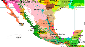
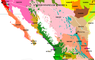
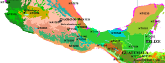
This article provides an overview and index to the Ecoregions of Mexico as defined by the World Wildlife Fund (WWF) and by the the Commission for Environmental Cooperation Working Group (CEC), a joint United States, Mexico, and Canada collaboration. There are a large number of terrestrial, freshwater and marine ecoregionsr that have all or part of their territory within Mexico. Collectively these ecoregions span a great species biodiversity, and many of these ecoregions provide a high degree of endemism. The high biodiversity within the ecoregions of Mexico can be partially explained by the great variation in altitude and latitude within the country, as well as the hydrographic variability of exposure on three separate major marine bodies: the Pacific Ocean, Gulf of Mexico and Caribbean Sea. The latitude difference embraces tropical, subtropical and temperate zones.
Contents
Background
An ecological region or "ecoregion" is an ecologically and geographically contiguous terrain of the Earth that typically covers a relatively large area of land or water, and is defined by characteristic, geographically distinct assemblages of natural communities and species. Characteristics of geographical phenomena may include geology, physiography,soils,vegetation, climate (Meteorology), topography, hydrology, terrestrial and aquatic fauna, and may or may not include the impacts of human activity (e.g. land use patterns, vegetation changes). Ecoregions thus denote areas of general similarity in ecosystems and in the type, quality, and quantity of environmental resources that humans use. They are designated to serve as a spatial framework for the research, assessment, management, and monitoring of ecological changes and ecosystem components. In particular, the ecoregion concept is central to the effort to monitor and conserve biological diversity.
The World Wildlife Fund (WWF) has defined 867 terrestrial ecoregions worldwide, 53 freshwater ecoregions. Sometimes the terrestrial ecoregions are grouped under a coarser scale of 142 ecoregions which combined with the freshwater and marine ecoregions form 238 ecoregions known as the "Global 200." Terrestrial ecoregions are also often grouped under 14 major habitat types.
Terrestrial Ecoregions in Mexico
The following WWF ecoregions are found in Mexico.
Tropical & Subtropical Dry Broadleaf Forests:
- Bajío dry forests (NT0204) occur in the Mexican Trans-volcanic Belt in the west central section of the country.
- Balsas dry forests (NT205) occur in the valley of the Balsas River and is bounded by the Trans-volcanic Belt to the north, the Sierra Madre del Sur to the south, and the highlands of Oaxaca to the east.
- Central American dry forests (NT0209) occurs in patches from southeast Mexico, through Guatemala, Honduras, El Salvador, and Nicaragua, ending in the transition zone of dry to moist forest in Costa Rica.
- Islas Revillagigedo dry forests
- Jalisco dry forests (NT0217) grow on a terrain dominated by small mountains that include lava spills and volcanic formations near the active Colima volcano on the western coast of central Mexico.
- Sonoran-Sinaloan transition subtropical dry forest (NA0201) form a transition ares south of the Sonorean desert along the eastern coast of the Baja California peninsula.
- Sierra de la Laguna dry forests (NT0227) occur in several areas of the southern tip of the Baja California peninsula
- Sinaloan dry forests (NT0228) stretch through three Mexican states, Sonora, Sinaloa and Nayarit, from the base of the Sierra Madre Occidental Mountains west to the Pacific Ocean
- Southern Pacific dry forests (NT0230) occupy a broad strip of south Mexico's Pacific coast.
- Veracruz dry forests (NT0233) occur is small patches along its central coastal plain of in state of Veracruz, in eastern Mexico, overlooking the Gulf of Mexico.
- Yucatán dry forests (NT0235) cover a swath of the Yucatán Peninsula north of the Yucatán moist forests
Tropical & Subtropical Coniferous Forests: 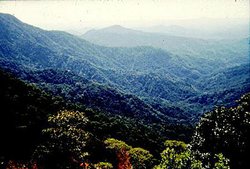 San Pedro Alta, Oaxaca. Source: WWF/D.Serbo
- Belizian pine forests (NT0302) cover much of Belize also occurs just north across the border in southern Quintana Roo region of Mexico
- Central American pine-oak forests (NT0303)are a major feature of Central America and stretch north into southern Mexico.
- Sierra de la Laguna pine-oak forests (NT0307) cover mountain tops in areas of the southern tip of Baja California peninsula
- Sierra Madre de Oaxaca pine-oak forests (NT0308) grow high in the Sierra Madre de Oaxaca Mountains of southern Mexico.
- Sierra Madre del Sur pine-oak forests (NT0309) cover the mountains of the Sierra Madre del Surin southern Mexico.
- Sierra Madre Occidental pine-oak forests (NA0302) cover the Sierra Madre Occidental Mountains of west-central Mexico between the Sonoran and Chihuahuan deserts.
- Sierra Madre Oriental pine-oak forests (NA0303) cover the Sierra Madre Occidental Mountains of of east-central Mexico
- Trans-Mexican Volcanic Belt pine-oak forests (NT0310) cover the tallest mountain range in Mexico which stretches across the country from the Pacific coast to near the Atlantic coast , in central Mexico.
Tropical & Subtropical Moist Broadleaf Forests:
- Central American montane forests (NT0112) occur in patchy, island-like mosaics on the isolated tops and slopes of the highest mountains of Central America, from southern Mexico into northern Nicaragua.
- Chiapas montane forests (NT0113) occur in amountainous are ofthe Chiapas region spreading over the border into Guatemala
- Chimalapas montane forests (NT0114) cover plateaus, valleys, and cliffs in a region of southern Mexico.
- Oaxacan montane forests (NT0146) grow on the northern slope of the Sierra Norte de Oaxaca in the Mexican states of Puebla and Oaxaca.
- Pantanos de Centla (NT0148) are seasonally flooded moist forests with associated with wetlands on the Caribbean coast of southern Mexico.
- Petén-Veracruz moist forests (NT0154) grow along the northeastern coastal plain of Mexico, in the northern portion of Veracruz and south Tamaulipas
- Sierra de los Tuxtlas (NT0161) covers an area which includes seven volcanoes mixed with a variety of lakes, lagoons, and marshlands on the Caribbean coast of southern Mexico.
- Sierra Madre de Chiapas moist forest (NT0162) occurs in a long corridor of land from southern Mexico into Guatemala and El Salvador.
- Veracruz moist forests (NA0176) form a bridge of vegetation between the Gulf of Mexico and the Pacific Ocean in southern Mexico overlapping the Mexico-Guatemala border.
- Yucatán moist forests (NT0181) cover a swath of the Yucatán Peninsula south of the Yucatán dry forests
Temperate Coniferous Forests:
- Sierra Juarez and San Pedro Martir pine-oak forests (NA0526) occur in several patches of northern Baja California
Mediterranean Forests, Woodlands, & Shrub:
- California coastal sage and chaparral (NA1201) occurs in the northwest region of Baja California where the ecoregion comes south across the border from California in the United States
Montane Grasslands and Shrublands
- Zacatonal (NT1009) occurs in the Trans-volcanic belt of central Mexico
Flooded Grasslands and Savannas:
- Central Mexican wetlands (NT0901) occur on a small set of lakes, rivers, and associated marshes and wetlands located in the middle of the rugged mountain range known as the Trans-volcanic belt in central Mexico.
- Chiapas Depression dry forests (NT0211) occur in a dry forest valley in southern Mexico and western Guatemala, cut by the Alto Grijalva River system and surrounded by mountainous terrain and mixed pine and oak forests.
- Western Gulf coastal grasslands (NA0701) occur in northwestern Mexico and the southern U.S. and extend in a coastal band along the western Gulf, including many near-shore islands.
Mangroves:
- Alvarado mangroves (NT1401) occur in northern Veracruz and Tampaulipas
- Bahamian mangroves (NT1403) are a significant ecoregion in the Carribean where they occur on the islands of the Bahamas and the Turks and Caicos, but also occur in a few coastal patches of central Mexico and southern Mexico.
- Baja mangroves (NT1404) spot the western Pacific coast of the Baja California peninsula and in one area of the eastern coast, while larger patchs of the coast on the easten shore of the Gulf of Mexicoand occur in places south along the Pacific coast.
- Marismas Nacionales-San Blas mangroves (NT1420) occur below the northwest mountains and plateaus of Mexico along the Pacific coast.
- Mayan Corridor mangroves (NT1421) occur on a vast plateau located on the Atlantic coast of the Mexican state of Quintana Roo on the Yucatan peninsula.
- Mexican South Pacific Coast mangroves (NT1402) are situated on the coastal plains of the Pacific, in the states of Michoacán, Guerrero, and Oaxaca.
- Northwest Mexican Coast mangroves (NT1401) occur in two main areas, one on the Pacific Coast and one on the Gulf of California Coast.
- Petenes mangroves (NT1428) lie along the far northwestern edge of the Yucatan Peninsula
- Ría Lagartos mangroves (NT1430) are found on the northern tip of the Yucatan Peninsula.
- Tehuantepec-El Manchon mangroves (NT1435) western portion of Chiapas, in southern Mexico, running northwest southwest on the Pacific Coastal Plain, parallel to the vast Sierra Madre de Chiapas.
- Usumacinta mangroves (NT1437) is located in the state of Tabasco in southern Mexico west of the Yucatan peninsula.
Deserts and Xeric Scrublands:
- Baja California desert (NA1301) covers much of Baja California except for the far north and south and the eastern coast strip of the peninsula.
- Central Mexican matorral (NA1302) lies south of the Meseta Central matorral in the southernmost section of the central Mexican mesa, flanked by the Sierra Madre Oriental Mountains in the east, the Sierra Madre Occidentals in the west, and the Trans-volcanic Belt in the south.
- Chihuahuan desert (NA1303) covers a larger region of central northern Mexico and across the border into the US states of Arizonia, New Mexico, and Texas.
- Meseta Central matorral (NA1307) is a desert plain that covers a plateau is located in north-central Mexico, bounded by the Sierra Madre Oriental Mountains in the east, the Sierra Madre Occidentals in the west, and the Trans-volcanic Belt in the south.
- Gulf of California xeric scrub (NA1306) covers the eastern coastal strip of the Baja California peninsula.
- San Lucan xeric scrub (NT1314) coversthe low lying coast regions of the southern tip of the Baja California peninsula
- Sonoran desert (NA1310) covers a large region of north western Mexico and across the border into the US states of Arizina and [[California]
- Tamaulipan matorral (NA1311) occur on the lower slopes of Sierra Madre Oriental that gradually diffuse into the northeastern coastal province of Tamaulipas.
- Tamaulipan mezquital (NA1312) cover southern Texas and northeast Mexico.
- Tehuacán Valley matorral (NT1316) occurs in southeast Puebla and northwestern Oaxaca states in south-central Mexico
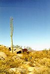 Near San Fernando, Baja California, Mexico (Source: Timothy Green)
 Freshwater Ecoregions in Mexico
WWF defines three freshwater ecoregions that are all or partially in Mexico
- Chihuahuan Freshwater
- Colorado River
- Mexican Highland Lakes
Marine Ecoregions in Mexico
WWF defines three marine ecoregions that are all or partially in Mexico while the United States National Oceanic and Atmospheric Administration defines four. Two of them are the same.
- Californian Current (WWF)/California Current large marine ecosystem (NOAA) to the northwest
- Gulf of California (WWF)/Gulf of California large marine ecosystem (NOAA) between Baja California and mainland Mexico
- Mesoamerican Reef (WWF)
- Gulf of Mexico large marine ecosystem (NOAA) to the east.
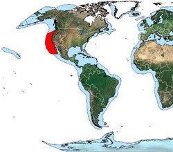 Location of the California Current LME, Gulf of California and Gulf of Mexico. (Source: NOAA) Location of the California Current LME, Gulf of California and Gulf of Mexico. (Source: NOAA) |
|
|
CEC Ecoregions in Mexico
The Commission for Environmental Cooperation has also defined more broad ecoregions within Mexico. The North American Deserts ecoregion extends into north central Mexico. In northeastern Mexico lies the Great Plains ecoregion that were once covered with natural grasslands. The Temperate Sierras ecoregion comprises the major Mexican mountain ranges. The Tropical Dry Forests ecoregion occupies the Northern Gulf Coastal Plain, the north of the Yucatán Peninsula and the southern tip of the Baja California Peninsula, covering almost 13 percent of Mexico. The Tropical Humid Forests ecoregion encompasses the Gulf Coastal Plain, the western and southern part of the Pacific Coastal Plain, most of the Yucatán Peninsula and the lowlands of the Chiapas Sierra Madre, which continue south to Central and South America.
References
- L.Arriaga, S. Díaz, R. Domínguez, y J. L. León. 1997. Composición florística y vegetación. Pages 69-106 in L. Arriaga, y R. Rodríguez-Estrella (editors). Los Oasis de la Península de Baja California. México: CIBNOR.
- S.D.Davis, V.H. Heywood, O. Herrera-MacBryde, J. Villa-lobos and A.C. Hamilton. 1997. Centres of Plant Diversity: A Guide and Strategy for their Conservation: Volume 3, The Americas. IUCN Publications Unit, Cambridge, U.K. ISBN: 2831701996.
- G. Gold-Bouchot, O. Zapata-Perez, E. Norena-Barroso, M. Herrera-Rodriguez, V. Ceja-Moreno, and M. Zavala-Coral, 1999. Oil Pollution in the Southern Gulf of Mexico. In: H.Kumpf, K. Steidinger, K. Sherman (editors), 1999. The Gulf of Mexico Large Marine Ecosystem: assessment, sustainability, and management. Blackwell Science, 736 pages. ISBN: 0632043350
- C.Michael Hogan. 2007. Lubaantun. The Megalithic Portal. ed. A.Burnham
- Roger Tory Peterson, Edward L. Chalif. 1999. A Field Guide to Mexican Birds: Mexico, Guatemala, Belize, El Salvador. Houghton Mifflin Harcourt. 320 pages
- Olson, D.M., E. Dinerstein, G. Cintrón, and P. Iolster. 1996. A conservation assessment of mangrove ecosystems of Latin America and the Caribbean. Final report for The Ford Foundation. World Wildlife Fund, Washington, D.C.
Return to the Latin America and the Caribbean Collection

