Malaysia
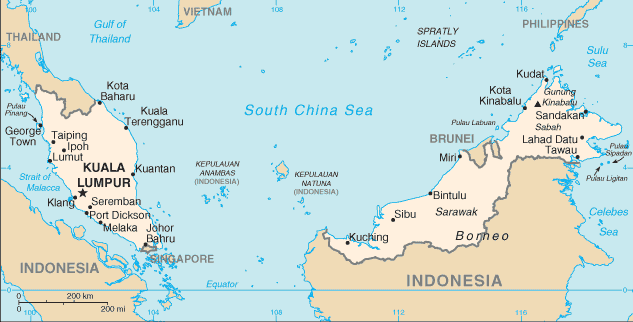
Countries and Regions of the World Collection  Malaysia is nation in Southeast Asia consisting of two disjunctive parts:
(1) Peninsular Malaysia bordering Thailand; and
(2) the northern one-third of the island of Borneo (the southern two thirds of Borneo being territory of Indonesia).
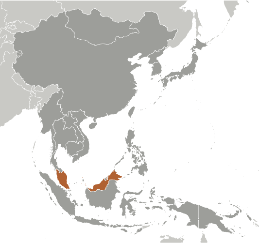
 Regional setting of Malaysia. Source: CIA World Factbook
Malaysia's chief environmental issues include: Palm oil plantations supplanting native forest; water pollution from raw sewage discharges; deforestation; air pollution from industrial and vehicular emissions; smoke/haze from Indonesian forest fires, chiefly from slash-and-burn activity.
Contents
History
Great Britain established colonies and protectorates in present day Malaysia during the late 18th and early19th centuries; these were occupied by Japan from 1942 to 1945. In 1948, the British-ruled territories on the Malay Peninsula formed the Federation of Malaya, which became independent in 1957. Malaysia was formed in 1963 when the former British colonies of Singapore and the East Malaysian states of Sabah and Sarawak on the northern coast of Borneo joined the Federation. The first several years of the country's history were marred by a communist insurgency, [[Indonesia]n] confrontation with Malaysia, Philippine claims to Sabah, and Singapore's secession from the Federation in 1965. During the 22-year term of Prime Minister Mahathir bin Mohamad (1981-2003), Malaysia was successful in diversifying its economy from dependence on exports of raw materials to expansion in manufacturing, services and tourism.
Geography
Location: Southeast Asia, peninsula bordering Thailand and the northern third of the island of Borneo, bordering Indonesia, Brunei, and the South China Sea, south of Vietnam. It has a strategic location along Strait of Malacca and southern South China Sea, Sulu Sea and Celebes Sea.
Geographic Coordinates: 2 30 N, 112 30 E
Area:329,847 km2 (328,657 km2 land and 1190 km2 water)
Arable land: 5.46%
Permanent crops: 17.54%
Other: 77% (2005)
Land Boundaries: 2669 km. Border countries: Brunei 381 km, Indonesia 1782 km, Thailand 506 km
Coastline: 4675 km (Peninsular Malaysia 2068 km, Malaysian Borneo 2607 km)
Maritime Claims: Territorial sea: 12 nautical miles; exclusive economic zone: 200 nautical miles and continental shelf: to 200 meters (m) depth or to the depth of exploitation; specified boundary in the South China Sea.
Natural Hazards: Flooding; tsunami; landslides; forest fires
Terrain:Coastal plains rising to higher elevation topography of hills and mountains. The highest point is Gunung Kinabalu (Mount Kinabalu) 4100 m
Climate: Malaysia lies entirely within the equatorial zone. The climate is governed by a regime of the northeast and southwest monsoons. The northeast monsoon blows from October to March, and produces intense rains which pound the east coast of Peninsular Malaysia and frequently cause widespread floods. It also causes the wettest season in Sabah and Sarawak. The southwest monsoon period occurs between May and September, and is a drier period for the entire nation.
Ecology and Biodiversity
See main articles: Ecoregions of Malaysia; Malaysia Biodiversity and Protected Areas Factsheet
There are a number of diverse ecoregions of Malaysia, including rainforests, peat swamp forests, montane alpine meadows and mangroves:
- Borneo lowland rainforests
- Borneo montane rainforests
- Borneo peat swamp forests
- Kinabalu montane alpine meadows
- Myanmar Coast mangroves
- Peninsular Malaysian montane rainforests
- Peninsular Malaysian peat swamp forests
- Peninsular Malaysian rainforests
- South China Sea Islands
- Sunda Shelf mangroves
- Tenasserim-South Thailand semi-evergreen rainforests
- Biological diversity in Indo-Burma
- Biological diversity in Sundaland
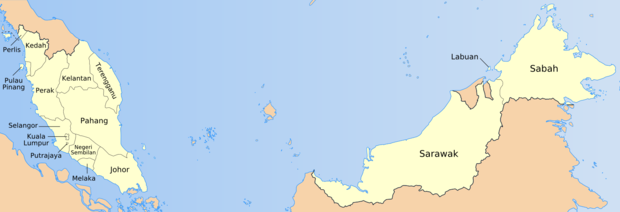
 The 13 States and three Federal Territories of Malaysia. Source: Golbez, Mdzafri
Protected Areas
See main article: Malaysia Protected Areas
There are a large number of protected areas of Malaysia, including both State and National holdings. These areas range over the gamut of forest types, mangrove systems, peat swamps, riverine areas and alpine meadows. The protection extended is particularly important because of the narrow endemism of many of Malaysia's species, and also because of imminent threats, particularly of extensive palm oil plantations.
Coral reef destruction and over-fishing are common in East Malaysia due to expanding human populations and the use of unsustainable fishery practices, such as cyanide fishing and blast fishing. Efforts to change these trends have been ineffective due to the inadequacy of enforcement and to the lack of appreciation by fishermen of the impacts of their actions. Blast and cyanide fishing for the live fish and aquarium trades has caused the destruction of vast tracts of coral reefs, accounting for the loss of more than eighty percent of original coral cover in many areas (Pilcher and Oakley, 1997). This loss of coral structures has resulted in the massive reduction of numbers of commercially valuable species along many parts of the Sabah coastline. The impacts and activities associated with blast fishing are daily events, throughout Sabah: "The destructive effects of one bomb, magnified thousand-fold by the extent to which this practice is employed, suggests that the fate of Sabah’s coral reefs is threatened in a significant manner. In addition, there are also stresses resulting from the release of excess sediment and nutrients from coastal development, agriculture and deforestation." (Pilcher & Cabanban, 2000) These extensive coral reef losses from direct anthropogenic effects are ongoing on coral reefs for Sabah, Labuan and Sarawak.
Environmental Agreements
Malaysia is party to international environmental agreements on Biodiversity, Climate Change, Climate Change-Kyoto Protocol, Desertification, Endangered Species, Hazardous Wastes, Law of the Sea, Marine Life Conservation, Ozone Layer Protection, Ship Pollution, Tropical Timber 83, Tropical Timber 94, and Wetlands.
Water Resources
See main articles: Water Profile of Malaysia; Malaysia Water Resources and Freshwater Ecosystems Factsheet (Malaysia Water Resources and Freshwater Ecosystems Factsheet); Lakes of Malaysia
Total Renewable Water Resources: 580 cu km (1999)
Freshwater Withdrawal: total: 9.02 cu km/yr (17% domestic, 21% industrial 62% agricultural). Per capita: 356 cu m/yr (2000)
Natural Resources
See main article: Malaysia Natural Resources
Important natural resources historically exploited in Malaysia include petroleum, timber, copper, iron ore, natural gas, bauxite.
Agriculture
See also Malaysia- FAO's Information System on Water and Agriculture
Agricultural products: Peninsular Malaysia - rubber, palm oil, cocoa, rice; Sabah - palm oil, subsistence crops, rubber, timber, coconuts, rice; Sarawak - palm oil, rubber, pepper, timber.
Irrigated Land: 3650 km2 (2003)
Energy
See also Energy profile of Malaysia
| Production | Consumption | Exports | Imports | Reserves | |
| Electricty | 103.2 billion kWh (2009 est.) | 99.25 billion kWh (2009 est.) | 2.268 billion kWh (2009 est.) | 0 kWh (2009 est.) | |
| Oil | 693,700 bbl/day (2009 est.) | 536,000 bbl/day (2009 est.) | 511,900 bbl/day (2007 est.) | 314,600 bbl/day (2007 est.) | 2.9 billion bbl (1 January 2010 est.) |
| Natural Gas | 57.3 billion cu m (2008 est.) | 26.27 billion cu m (2008 est.) | 31.03 billion cu m (2008 est.) | 0 cu m (2008 est.) | 2.35 trillion cu m (1 January 2010 est.) |
People and Society
Population: 28,728,607 (July 2011 est.)
Age Structure:
0-14 years: 29.6% (male 4,374,495/female 4,132,009)15-64 years: 65.4% (male 9,539,972/female 9,253,574)65 years and over: 5% (male 672,581/female 755,976) (2011 est.)
Population Growth Rate: 1.576% (2011 est.)
Birthrate: 21.08 births/1,000 population (2011 est.)
Death Rate: 4.93 deaths/1,000 population (July 2011 est.)
Net Migration: -0.39 migrant(s)/1,000 population
Urbanization:72% of total population (2010) increasing at a rate of 2.4% annual rate of change (2010-15 est.)
Health: For major infectious diseases, Malaysia is characterised as having a high degree of risk. Particular disease syndromes present in the country of Malaysia are waterborne and food-borne diseases, especially bacterial diarrhea. Chief vectorborne diseases are Dengue fever and malaria.
Life Expectancy at Birth: 73.79 years
Total Fertility Rate: 2.67 children born/woman (2011 est.)
Languages: Bahasa Malaysia (official), English, Chinese (Cantonese, Mandarin, Hokkien, Hakka, Hainan, Foochow), Tamil, Telugu, Malayalam, Panjabi, Thai. In East Malaysia there are several indigenous languages; most widely spoken are Iban and Kadazan
Literacy: 88.7% (male: 92%; female: 85.4% (2000 census)
Economy
Malaysia, a middle-income country, has transformed itself since the 1970s from a producer of raw materials into an emerging multi-sector economy. Under current Prime Minister NAJIB, Malaysia is attempting to achieve high-income status by 2020 and to move farther up the value-added production chain by attracting investments in Islamic finance, high technology industries, biotechnology, and services. The Najib administration also is continuing efforts to boost domestic demand and reduce the economy's dependence on exports. Nevertheless, exports - particularly of electronics, oil and gas, palm oil and rubber - remain a significant driver of the economy. As an oil and gas exporter, Malaysia has profited from higher world energy prices, although the rising cost of domestic gasoline and diesel fuel, combined with strained government finances, has forced Kuala Lumpur begin to reduce government subsidies. The government is also trying to lessen its dependence on state oil producer Petronas, which supplies more than 40% of government revenue. The central bank maintains healthy foreign exchange reserves and its well-developed regulatory regime has limited Malaysia's exposure to riskier financial instruments and the global financial crisis. Nevertheless, decreasing worldwide demand for consumer goods hurt Malaysia's exports and economic growth in 2009, although both showed signs of recovery in 2010. In order to attract increased investment, Najib has raised possible revisions to the special economic and social preferences accorded to ethnic Malays under the New Economic Policy of 1970, but he has encountered significant opposition, especially from Malay nationalists and other vested interests.
GDP: (Purchasing Power Parity): $416.7 billion (2010 est.)
GDP: (Official Exchange Rate): $219 billion (2010 est.)
GDP-real growth rate: 7.2% (2010 est.)
GDP- per capita (PPP): $14,700 (2010 est.)
GDP- composition by sector:
Agriculture: 9.1%Industry: 41.6%Services: 49.3% (2010 est.)
Industries: Peninsular Malaysia: rubber and palm oil processing and manufacturing, light manufacturing, electronics, tin mining and smelting, logging, timber processing; Sabah: logging, petroleum production; Sarawak: palm oil processing, agricultural processing, petroleum production and refining, logging.
Currency: Ringgits (MYR)
Government
See main article: Governance of Malaysia
Government Type: Constitutional monarchy with a bicameral Parliament consisting of a nonelected upper house and an elected lower house; all Peninsular Malaysian states have hereditary rulers (commonly referred to as sultans) except Melaka and Pulau Pinang (Penang); those two states along with Sabah and Sarawak in East Malaysia have governors appointed by government; powers of state governments are limited by federal constitution
Capital: Kuala Lumpur
Independence Date: 31 August 1957 (from the United Kingdom)
Legal System: Based on English common law; judicial review of legislative acts in the Supreme Court at request of supreme head of the federation; Islamic law applies to Muslims in matters of family law and religion; has not accepted compulsory International Court of Justice jurisdiction.
See Also
- Geography of Malaysia
- Malaysia Summary Factsheet
- Malaysia Protected Areas
References
- Malaysia Department of Agriculture. 1994. Paddy statistics of Malaysia: Peninsular Malaysia,
- Malaysia Department of Environment. 1994. Environmental quality report. Malaysia.
- Malaysis Department of Forestry, Peninsular Malaysia. 1994. Annual report. Malaysia.
- Malaysia Department of Irrigation and Drainage. 1982. National water resources study, p. 7-14. Main Report, Vol. 1. Master Action Plan. Malaysia.
- Malaysia Department of Statistics. 1997. Statistics handbook, p. 74. Malaysia.
- Malaysia Economic Planning Unit, Prime Minister's Department. 1996. Seventh Malaysia plan. Malaysia.
- J.MacKinnon. 1997. Protected areas systems review of the Indo-Malayan realm. Canterbury, UK: The Asian Bureau for Conservation (ABC) and The World Conservation Monitoring Center (WCMC)/ World Bank Publication.
- L.C.Myers. 1978. The geomorphology. Pages 91-100 in D.M.Luping, C.Wen, and E.R.Dingley (editors), Kinabalu: Summit of Borneo. Sabah, Malaysia: The Sabah Society.
- National Geographic Society. 1999. National Geographic Atlas of the World: Seventh Edition. Washington, DC: National Geographic Society. ISBN: 0792267559
- Pilcher, N. and A. Cabanban , 2000 , The Status of Coral Reefs in Eastern Malaysia . Global Coral Reef Monitoring Network (GCRMN) Report. Australia Institute of Marine Science, Townsville (See Document)
- A.J.Stattersfield, M.J.Corsby, A.J.Long, and D.C.Wege. 1998. Global Directory of Endemic Bird Areas. Cambridge, UK: Birdlife International.
- M.D.F.Udvardy. 1975. A classification of the biogeographical provinces of the world. IUCN Occassional Paper No 18.
- U.S.Geological Survey. 1996. Global 30 arc second elevation data (Gtopo30). EROS data center.
- World Wide Fund for Nature (WWF) and The World Conservation Union (IUCN) 1995. Centres of Plant Diversity: A Guide
- Neo,T.L. 1996. Proceedings of the regional seminar on integrated river basin management. Melaka. Malaysia, Vol.1.
- Alistar I. Robertson. 1992. Tropical mangrove ecosystems. American Geophysical Union. 329 pages
- Li and Sun. 1999. Palynological records since Last Glacial Maximum from a deep-sea core in the southern South China Sea. Quat. Sci. Rev. 23: 2007-2016
- Pinxian Wang. 2009. The South China Sea: Paleoceanography and Sedimentology (Google eBook) Springer. 506 pages
- Eric D.Wikramanayake. 2002. Terrestrial ecoregions of the Indo-Pacific: a conservation assessment. Island Press. 643 pages
- United Nations. 2006. Malaysia. Food and Agriculture Organisation of the United Nations
- United States Central Intelligence Agency. Malaysia Factsheet. U.S. Government Printing Office, Washington DC
- World Resources Institute. 2003. Malaysia Factsheets. EarthTrends

