South China Sea Islands
The South China Sea islands ecoregion encompasses several hundred islands, atolls, rocks, cays, banks, and reefs in three principal archipelagos of the South China Sea. Coral reefs are the predominant structure of these islands; the Spratly group contains over 600 coral reefs in total. Little vegetation grows on these islands, which are subject to intense monsoons. They do, however, provide important habitat for many seabirds, as well as green and hawksbill sea turtles. Unfortunately, the South China Sea Islands are still largely a mystery. Scientists have focused their research on the marine environment, while the ecology of the terrestrial environment remains relatively unknown. Ownership of many of the islands in this busy commercial fishery and trade route is disputed. Political instability and the increasing industrialization of neighboring countries has led to serious disruption of native flora and fauna, overexploitation of natural resources, and environmental pollution.
Location and General Description
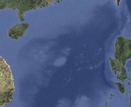
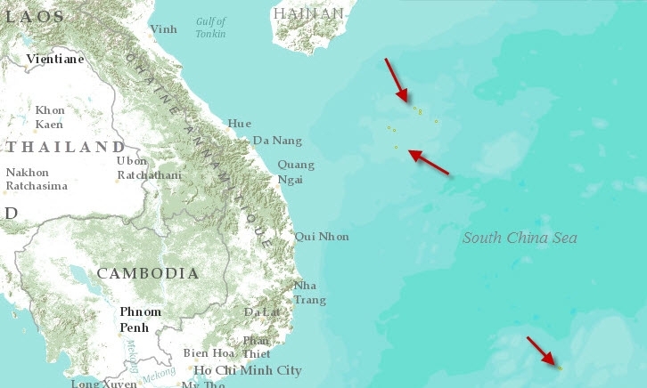
Three archipelagos or island groups are included in the South China Sea Islands terrestrial ecoregion. These are Pratas (Dungsha) (20°42’N, 116°43’ E), Paracel (Xisha) (16° N, 112° E), and Spratly (Nansha), which is the largest archipelago in the South China Sea. The Spratly Islands are scattered between 11°28’ to 4° N and 109°55’ to 117°50’ E. While land formations are numerous within this region, the majority of these are rocks, reefs, sandbanks, or other types of partially submerged landforms. In addition to the three major island groups, there are a moderate number of small scattered near-coastal islands off of Northern Borneo and southern China.
Located offshore midway between Hong Kong and Taiwan, Pratas Island (Dungsha Tao) is the northernmost coralline island in the South China Sea. The island emerges from the western extreme of Dungsha Atoll, and is 2500 metres (m) long and 865 m wide with an area of 1.74 square kilometres (km2), of which 0.64 km2 is a lagoon no deeper than 1.5 m. The entire island is sand, with no soil present. The Paracel Islands are located about one-third of the way from central Vietnam to the northern Philippines. Encompassing several small islands and reefs, it is not far from Hainan Dao, China’s largest island. Located 160 km north of Malaysia and 100 km west of the Philippines, the Spratlys include approximately 150 named landforms, and innumerable unnamed spits of land. Volcanic formation continues in this region, and could lead to new, uncharted emergents. The largest island in the Spratly group, Taping Island, is only 1470 m long and 350 m wide, with less than 0.5 km2 of land area. The island’s entire topography is less than five m in elevation.
Climate varies slightly between the island groups. The northern Paracel group has a subtropical marine climate, dominated by trade winds that blow from the southwest May to August and from the northeast November to March. Total annual precipitation is 1132.5 millimetres (mm), with a maximum in June (226.0 mm) and minimum in December (3.3 mm). The Spratly group has a more southerly tropical climate. Average annual temperature is 27°C. During summer, from May to August, the high temperature is approximately 30°C, while the winter average temperature is about 25°C. The Spratlys experience a seven month dry season and a five month rainy season, with an annual average |rainfall of 1800 to 2200 mm. Southeast monsoon winds blow from March to April, then shift to a southwest monsoon wind from May to November. Few islands have freshwater, though on some, wells have been dug successfully and over the years provided a source of water to visiting fishermen.
With little or no soil, a long dry season, and heavy [[wind]s] blowing much of the year, a great number of the tiny islands of the South China Sea are entirely devoid of vegetation. Larger islands, however, are capable of supporting tropical forest, scrub forest, and coastal scrub and grasses. For Paracel Island, the largest in its group, the majority of flora present are Pantropic species. Paracel’s vegetation is very similar to that of Hainan Island, China’s largest island and the Paracel Archipelago’s neighbor to the north. The primary types of vegetation on Paracel are coral island evergreen forest, scrub forest, and coastal scrub and grasses. There are 340 species recorded in 89 families and 224 genera. These include 22 species of macromycetes (larger fungi), only one species of lichen, five species of pteridophytes (ferns and fern allies), and 312 species of angiosperms (flowering plants).
Little information is available describing the vegetation of the South China Sea Islands, and it is sometimes difficult to discern which species have been introduced or cultivated by humans. Taiping Island, or Itu Aba Island, of the Spratly group, was reportedly covered with shrubs, coconut, and mangroves in 1938; pineapple has also been cultivated here. Other accounts mention papaya, banana, coconut and palm, and even white peach trees growing on one island. A few islands have been developed as small tourist resorts, and have had soil and trees brought in and planted where there were none.
Biodiversity Features
Little is known about the terrestrial biodiversity of the South China Sea Islands, as they have not been studied in scientific detail. Primarily, research is focused on the marine environment, which is extremely important to the region. The islands are frequented by marine turtles and many species of seabirds.
Both the green turtle (Chelonia mydas) and the hawksbill turtle (Eretmochelys imbricata) formerly occurred in numbers sufficient to support commercial exploitation. These species reportedly continue to nest even on islands inhabited by military personnel (such as Pratas) to some extent, though it is believed that their numbers have declined.
Seabirds use the islands for resting, breeding, and wintering sites. Species found here include streaked shearwater (Calonectris leucomelas), brown booby (Sula leucogaster), red-footed booby (S. sula), great crested tern (Sterna bergii), and white tern (Gygis alba). Little information is available regarding current status of the islands’ seabird populations, although it is likely that birds may divert nesting site to smaller, less disturbed islands. Bird eggs cover "every inch" of Nan Tzu Chiao, a small island in the eastern Danger Zone of the Spratlys.
Current Status
Rich fishing grounds, a potential for gas and oil deposits, and strategic location have caused many of the South China Sea islands to be claimed by China, Taiwan, and Vietnam, Malaysia, and the Philippines. All five parties have occupied certain islands or reefs, and occasional clashes have occurred between Chinese and Vietnamese naval forces. Being bordered by some of the world's most rapidly industrializing countries as well as being located inside some of the world's busiest shipping lanes, has proven detrimental to the island ecosystems in many ways. Concerns with political disputes, maximizing economic growth, and ensuring adequate energy supplies have taken precedent over preservation of the bordering nations’ common maritime environment. In effect the oceanic hub of Asia's industrial revolution, the South China Sea islands have been and are being degraded by physical disruption of native flora and fauna, overfishing, overexploitation of natural resources (guano, turtles), and water pollution.
Both the green turtle (Chelonia mydas) and the hawksbill turtle once inhabited these islands in large numbers, but they have since been subjected to heavy commercial exploitation. Senior officers stationed on Pratas Island reported densely populated nesting beaches 10 to 20 years ago. Disruption of nesting areas by human activity or by introduced animals (Alien species), such as dogs, has reduced the number of turtles nesting on the islands. Sea turtles are also slaughtered for food on a significant scale. The sea turtle is a symbol of longevity in Chinese customs, however, and at times the military personnel are given orders to protect the turtles.
Heavy commercial fishing in the region produces other ecological problems. Though it has been outlawed, fishing methods continue to include the use of bottom trawls fitted with chain rollers. In addition, during a recent routine patrol, more than 200 kilograms (kg) of potassium cyanide (KCN) solution was confiscated from fishermen who had been using it for fish poisoning. These activities have a devastating impact on local marine organisms and coral reefs.
Some interest has been taken in regard to conservation of these island ecosystems. One region of the Spratly Archipelago, called Truong Sa in Vietnam, was proposed by that country’s Ministry of Science, Technology and the Environment (MOSTE) as a future protected area. The 160 km2 site is currently managed by the Khanh Hoa Provincial People’s Committee of Vietnam.
Types and Severity of Threats
Military groups in the Spratlys engage in environmentally damaging activities such as shooting turtles and seabirds, paving coral reefs and atolls, raiding nests, and fishing with explosives. The collection of rare medicinal plants and wood and hunting for the wildlife trade are common threats to the biodiversity of the entire region, including these islands. Coral reef habitats are threatened by water pollution surface runoff, over-exploitation of fish and invertebates, and the use of explosives and poisons as fishing techniques.(Kimura et al, 2008)
References
- BirdLife International, compiled in conjunction with the Forest Inventory and Planning Institute. 2001. The Sourcebook of Existing and Proposed Protected Areas in Vietnam.
- Cheng, I. 1995. Sea Turtles At Dungsha Tao, South China Sea. Marine Turtle Newsletter.
- Kimura, T., C.F. Dai, H-S. Park, H. Hui and P.O. Ang. 2008. Status of Coral Reef Resources in East and North Asia (China, Hong Kong, Taiwan, South Korea and Japan). In: Wilkinson, C. (ed.). Status of Coral Reefs of the World: 2008. Global Coral Reef Monitoring Network and Reef and Rainforest Research Center, Townsville, Australia. p145-158.
- McManus, J.W. 1994. The Spratly Islands: a marine park?
- Shi-Ching, H. 1999. The Nanshas (Spratlys) Disputes. Color Lithographic Press, Inc., Quezon City, The Philippines.
- Valencia, M. J., J. M. Van Dyke, and N. A. Ludwig. 1999. Sharing the Resources of the South China Sea. University of Hawaii Press, Hawaii. ISBN: 9041104119
- Xing, Fu-Wu, Wu, Te-Lin, Li, Ze-Xian, Ye, Hua-Gu, and Chen, Bing-Hui. 1993. Investigation of plant resources in Xisha Islands. Journal of Plant Resources and Environment 2:1-6.
| Disclaimer: This article contains certain information that was originally published by the World Wildlife Fund. Topic editors and authors for the Encyclopedia of Earth have modified its content and added new information. The use of information from the World Wildlife Fund should not be construed as support for or endorsement by that organization for any new information added by EoE personnel, or for any editing of the original content. |

