Sulu Sea
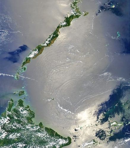
Sulu Sea viewed from space, showing near enclosure. Source: NASA
Seas of the World ![]() The Sulu Sea is a tropical seawater body in the Malayan Archipelago of Southeast Asia.
The Sulu Sea is a tropical seawater body in the Malayan Archipelago of Southeast Asia.
It is partitioned from the South China Sea in the northwest by the Phillipines island province of Palawan; moreover, the Sulu Sea is joined to the Celebes Sea in the southeast through the Sulu Archipelago.
Sabah, Malaysia on Borneo is found to the southwest and Visayas to the northeast. 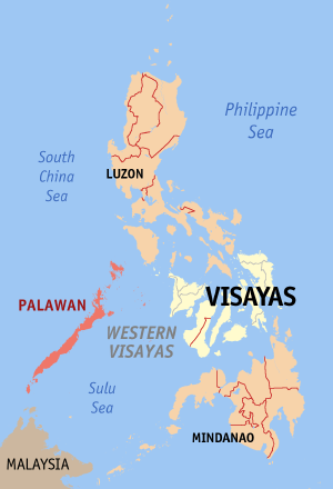 Regional setting of the Sulu Sea.
The Cuyo Archipelago consisting of 45 separate islands, lies within the Sulu Sea as Philippine territory, as part of the province of Palawan. The Sulu Sea also holds Mapun Island and the Turtle Islands are within the Philippine province of Tawi-Tawi. Furthermore, the Sulu basin contains the Tubbataha Reef National Marine Park, an atoll coral reef within Philippines waters that is inscribed as a UNESCO World Heritage Site.
Contents
Limits
The International Hydrographic Organization defines the Sulu Sea as being one of the waters of the East Indian Archipelago. The limits then are:
- At the northwest. From Tanjong Sampanmangio, the northernmost point of Borneo, along the eastern limit of South China Sea to Cape Calavite, the northwest point of Mindoro.
- At the northeast. The southwest coast of Mindoro to Buruncan Point, its southern extremity, thence a line through Semirara and Kaluya Islands to Nasog Point (11°53′N 121°53′E / 11.883°N 121.883°E / 11.883; 121.883) the northwestern extreme of Panay, along the west and southeast coast of Panay island to Tagubanhan Island (11°08′N 123°07′E / 11.133°N 123.117°E / 11.133; 123.117), thence a line to the northern extreme of Negros and along the west coast to Siaton Point, its southern extreme, thence across to Tagolo Point (8°44′N 123°22′E / 8.733°N 123.367°E / 8.733; 123.367), Mindanao.
- At the southeast. From Tagolo Point, along the western coastline of Mindanao to the southwest extreme, thence to the north coast of Basilan Island (6°45′N 122°04′E / 6.75°N 122.067°E / 6.75; 122.067), through Basilan island to its southern limit, thence a line to Bitinan Island (6°04′N 121°27′E / 6.067°N 121.45°E / 6.067; 121.45) off the eastern tip of Jolo Island, through Jolo to a point in long. 121°04'E on its South coast, thence through Tapul and Lugus Islands and along the northern coast of Tawitawi Island to Bongao Island off its western end (5°01′N 119°45′E / 5.017°N 119.75°E / 5.017; 119.75), and from thence to Tanjong Labian, the northeastern extreme of Borneo.
- At the southwest. The north coast of Borneo between Tanjong Labian and Tanjong Sampanmangio.
Marine Ecology
See main article: Sulu-Celebes Sea Large Marine Ecosystem
Surface currents in the Sulu Sea arrive from the south in the summer. Winter currents follow an anti-clockwise gyre. In the Celebes Sea, strong currents, deep sea trench topography, seamounts and active volcanic islands result in a complex oceanography. The tropical climate, clear tropical waters of the Celebes Sea, active underwater volcanoes, seamounts, trenches,corals and inter-island passages, currents and upwellings, all make this an exceptionally rich area with great marine biodiversity.
There are over 1800 species of fish, more than 400 species of algae, five species of sea turtles, 22 species of marine mammals and over 450 types of coral. There are also Orcas, other cetaceans, sharks, manta rays and pelagic fishes such as tuna and marlin. In the Sulu Sea, Apo Reef and Tubbataha Reef have been shown to be at the center of a system of currents distributing fish and lobster larvae throughout the area. The Sulu-Celebes Seas LME is considered a Class III, low productivity ( <150 grams of carbon per square meter per year) ecosystem.
Water Quality and Conservation Threats
Years of overfishing using dynamite and cyanide have taken their toll on the coral reefs in the Philippine waters of the Sulu Sea. In Philippine waters the marine resources are overstretched, as evidenced by the recent decline in tuna exports. The export and domestic markets continue to ignore the ecological limits of the ecosystem. Damage to coral communities is caused by careless divers and by boat anchors. Illegal tours by collectors cause loss of turtle eggs, giant clams and seashells.
The Tubbataha Reefs are not free from intrusion and destruction, even though they have nominal protection. Both Tubbataha Reef and Turtle Island have fallen prey to the destructive practices of illegal harvesting of turtle eggs, thereby endangering the very existence of these sea turtles. Local extinction, according to the World Wildlife Fund, is imminent. In 1995, the Philippines Department of Environment and Natural Resources revealed that coral cover and fish density in the reefs are "decreasing at an alarming rate" despite the site's official status as a protected National Marine Park.
Based upon sampling of fish tissue at Bathypelagic zone levels, the Sulu Sea biota demonstrated lower lipid concentrations of DDT, PCBs and other organochlorine pesticides relative to fish tissue from similar depth zones in the East China Sea, Tosa Bay and several other locations in the Indo-Pacific region. The suggestion was made that the low level of anthropogenic activity in the Sulu Sea may explain the results. The data is also notable, due to the high level of containment of the Sulu Sea, which is surrounded by land and shallow sills (less than 200 meters in depth).
Terrestrial Ecology
See main article: Borneo Lowland Rainforests
The key western terrestrial margin of the Sulu Sea is comprised of Malaysia's Borneo Lowland Rainforests. These lowland dipterocarp rainforests are deemed by many as the biologically richest rainforests in the world, rivalling the biodiversity of New Guinea and the Amazon. With 267 Dipterocarpaceae species (155 endemic to Borneo), Borneo is the center of the world's diversity for dipterocarps. These forests are home to the world's smallest squirrel, the eleven centimetre long pygmy squirrel, and the endangered orangutan. Much of the land area draining to the Sulu Sea from Borneo is within Sabah's Kinabatangan River watershed, whose river mouth itself is at the edge of the Sulu Sea
In northeast Borneo, populations of Sumatran rhinoceros and Asia's largest terrestrial mammal, the Asian pygmy elephant, tenuously survive in the last pockets of forest. These forests contain the parasitic plant Rafflesia arnoldii, which produces the world's largest flower (up to one metre in diameter). These forests are globally outstanding for both bird and plant [[rich]ness], with more than 380 birds and an estimated 10,000 plant species found within its boundaries. The Borneo lowland rainforests on the Island of Borneo have been rapidly converted to oil palm plantations or commercially logged at unprecedented rates over the past fifteen years.
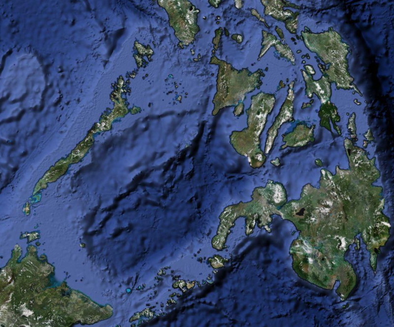 Source: Google Maps
References
- International Hydrographic Organization. 1953. Limits of Oceans and Seas, 3rd edition.
- NOAA. 1991. Report of the ad hoc Committee on Large Marine Ecosystems. NOAA Technical Memorandum NMFS-F/NEC-92, 19p.
- Karri Ramu, Natsuko Kajiwara, Hiroko Mochizuki, Hitoshi Miyasaka, Kwadwo A.Asante, Shin Takahashi, Sugura Ota, Hsin-Ming Yeh, Shuhei Nishida, Shinsuke Tanabe. 2006. Occurrence of organochlorine pesticides, polychlorinated biphenyls and polybrominated biphenyl ethers in deep-sea fishes from the Sulu Sea. Marine Pollution Bulletin. 52: 1784-1832
- Chua Thia-Eng and J.A.Mathias (Editors). 1978. Coastal resources of West Sabah: An investigation into the impact of oil spill. Penerbit Universiti Sains Malaysia, Pulau Pinang, Malaysia. 296 pp.
- Li and Sun. 1999. Palynological records since Last Glacial Maximum from a deep-sea core in the southern South China Sea. Quat. Sci. Rev. 23: 2007-2016
- Eric D.Wikramanayake. 2002. Terrestrial ecoregions of the Indo-Pacific: a conservation assessment. Island Press. 643 pp.