Tibetan Plateau alpine shrub and meadows
The Tibetan Plateau Alpine Shrublands and Meadows ecoregion forms a transition zone between eastern and western portions of the Tibetan Plateau.This ecoregion is home to a large number of wild ungulates; however, they are rapidly being displaced by grazing of domestic livestock, increasing populations, and hunting.The large carnivores of the Tibetan Plateau – brown bears (Ursus arctos), wolves (Canis lupus) and snow leopards (Panthera uncia) – probably occur here as well, although their density has become quite low, due to human encroachment and exploitation.The region supplies the headwaters and upper catchments of the Yellow River and Yangtze River.
Location and General Description
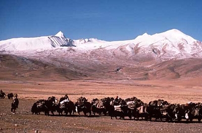
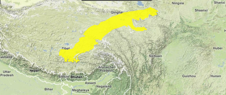
Wet sedge meadows of eastern Tibet merge with the semi-arid steppes and cold deserts of the western part of the Tibetan Plateau in a transition zone broad enough to constitute a distinct ecoregion. The Tibetan Plateau alpine shrublands and meadows ecoregion extends more than 1500 kilometers (km) northeastward from the northern margin of the Tsangpo River Valley near Lhasa to the Qilian Mountains east of Qinghai Lake. This area, which includes the headwaters of China’s two largest rivers, has a long tradition of use by semi-nomadic pastoralists.
This ecoregion, which includes the headwaters and upper catchments of the Yellow and Yangzi Rivers, consists of wide basins and low hills at elevations of from 4000 to 4500 meters (m). The landscape here is more eroded than in western Tibet, but still forms a nearly continuous plain. The boundaries of this ecoregion are defined by a gradient of decreasing precipitation that extends across the Tibetan Plateau from southeast to northwest. The vegetation here represents a broad ecotone between alpine steppe to the northwest where precipitation is less than 400 millimeters (mm) per year and moist, cool Kobresia sedge meadows to the southeast where precipitation is greater than 500 mm per year. Annual mean temperatures range from –3 to 0oCelcius (C), with mean temperatures during the warmest part of the year of about 8 to 10oC, too cold to support trees even if soil and moisture conditions were favorable.
The Tibetan Plateau alpine shrublands and meadows ecoregion supports vegetation that is transitional between the cold, moist environments in the eastern part of the Tibetan Plateau and the cold drier steppes and alpine deserts that lie to the west. Here westerly winds reinforce the continental climate and the South Asian monsoon is less important as a source of summer precipitation. Mesic alpine forbs are less frequent than to the east, but still form important associates with the dominant sedge vegetation. Meadows consist mainly of Kobresia (K. pygmaea and K. humilis) and Carex atrata sedge, often associated with forbs such as knotweed (Polygonum sphaerostachyum), meadow rue (Thalictrum alpinum), everlasting (Anaphalis xylorrhiza), edelweiss (Leontopodium pusillum), blue poppy (Meconopsis horridula), Potentilla spp., Pedicularis spp., and Gentiana spp.
As is typical throughout much of the Eastern Himalayan alpine region, aspect determines the physiognomy of the vegetation. South-facing slopes, often snow-free and exposed to cold wind during winter, support sedge meadow vegetation while sheltered, north-facing sites support evergreen shrubs such as juniper (Juniperus) and rhododendron (R. setosum and R. cephalanthus). Valley bottoms with stable, well-drained soils support deciduous shrubs, such as cinquefoil (Potentilla fruticosa), the legume (Caragana jubata), and willows (Salix spp).
As in other parts of the Tibetan Plateau, local zonation of plant communities is observed on mountain slopes. Shrubs dominate the lower slopes, especially north-facing aspects. Kobresia meadows occur in the higher, drier locations, with cushion plants (Arenaria musciformis and Androsace tapete). Expanses of bare gravel are found at the sub-nival elevations above 5,000 m.
Because the Tibetan Plateau is gently inclined, with the highest elevations in the northwest, latitude and elevation jointly define a gradient of cooling temperatures from southeast to northwest. Latitude affects temperature by controlling the angle and intensity of solar radiation. Elevation affects temperature by controlling the air pressure and hence the heat capacity of the air.
The alpine zone in Tibet includes all areas where the average temperature during July, the warmest month of the year, is not more than 10oC. In fact, almost all of the plateau except the southern river valleys–the Indus, Sutlej, and Tsangpo (including the Lhasa Valley)–falls within this "high cold" alpine zone. Within the alpine, moisture determines whether a region supports [meadow]], steppe or alpine desert vegetation. As precipitation decreases northwestward, vegetation changes from dense scrub to meadow to steppe to desert. In Tibet, forests are confined to valleys. Forests never occur on the plateau due to cold, continental climate and the fact that the plateau lies above the 10o isotherm.
Biodiversity Features
Many of the ungulates characteristic of the both the eastern and western parts of the Tibetan Plateau occur in this ecoregion. Alpine shrublands and meadows are favored habitat for white-lipped deer (Cervus albirostris), Tibetan wild ass (Equus kiang), Tibetan gazelle (Procapra picticaudata), and blue sheep (Pseudois nayaur). A few argali (Ovis ammon) are recorded in the literature, although these large mountain sheep are more abundant in the higher Changtang region that lies to the northwest. The large carnivores of the Tibetan Plateau – brown bears (Ursus arctos), wolves (Canis lupus) and snow leopards (Panthera uncia) – probably occur here as well, although their density would be very low.
Current Status
While the vegetation is mostly intact, wild animal populations are in a state of decline throughout this ecoregion. This is based on a comparison of population numbers and distribution today, relative to the numbers that appear in historical accounts of the area.
Types and Severity of Threats
This relatively lush region of the Tibetan Plateau has been actively grazed by domestic livestock for many years. The presence of herders and their animals has probably had some effect on the number of wild ungulates that the region can support, although it is difficult to acquire data as to the magnitude of their impact. It is also difficult to measure the ecological effect of grazing by domestic livestock, since there is little data available about the effects of grazing by the herds of wild ungulates that were present here before pastoralists arrived.
Another concern is immigration into this area from other parts of China. Establishment of new towns on the Tibetan Plateau, largely populated by non-Tibetan people, and increases in hunting and wildlife trade pose an increased threat to the wildlife.
Justification of Ecoregion Delineation
Ecoregion boundaries correspond to the vegetation transition zone located between warmer, wetter, southeast Tibetan shrublands interspersed with woodlands and forests, and the cold, dry Central Tibetan Plateau grasslands. This transition zone is easily detected on the one kilometer map of global land cover produced by University of Maryland. It appears as a relatively pure grassland belt in southeast Tibet.
Additional information on this ecoregion
- For a shorter summary of this entry, see the WWF WildWorld profile of this ecoregion.
- To see the species that live in this ecoregion, including images and threat levels, see the WWF Wildfinder description of this ecoregion.
Further Reading
- Chang, D.H.S. 1981. The Vegetation Zonation of the Tibetan Plateau. Mountain Research and Development 1(1): 29-48.
- Hansen M.C., R.S. Defries, J.R.G. Townshend, and R.Sohlberg. 2000. Global land cover classification at 1 km spatial resolution using a classification tree approach. International Journal of Remote Sensing 21(6-7):1331-1364.
- Mackinnon, J., M. Sha, C. Cheung, G. Carey, Z. Xiang, and D. Melville. 1996. A biodiversity review of China. World Wide Fund for Nature, Hong Kong.
- MacKinnon, J. 1996. Wild China. The MIT Press, Cambridge MA. ISBN: 0262133296
- MacDonald, D. editor. 1999. The Encyclopedia of Mammals. Barnes and Noble Books. ISBN: 0199206082
- Schaller, G.B. 1998. Wildlife of the Tibetan Steppe. The University of Chicago Press, Chicago. ISBN: 0226736539
- Zhao, J., editor, Zheng Guangmei, Wang Huadong, Xu Jialin. 1990. The Natural History of China. McGraw Hill Publishing Company, New York. ISBN: 0002190435
| Disclaimer: This article is contains some information that was originally published by the World Wildlife Fund. Topic editors and authors for the Encyclopedia of Earth have edited its content and added new information. The use of information from the World Wildlife Fund should not be construed as support for or endorsement by that organization for any new information added by EoE personnel, or for any editing of the original content. |


.jpg)
