Kalaallit Nunaat high arctic tundra
Location and General Description
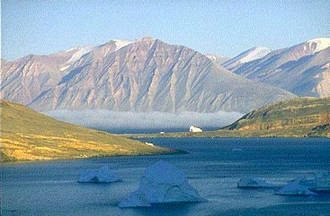
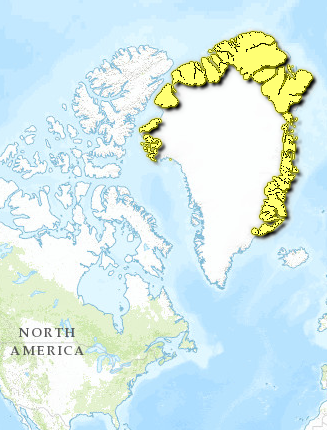
Greenland is the world’s largest island, though four-fifths of the land area lies beneath the second largest ice cap in the world. Ice-free areas are restricted to the coastal fringes, which can be divided into two biogeographic regions: the low and the High Arctic Tundra. The high arctic region is located above 75°N latitude at Melville Bay on the West Coast and 70°N at Scoresby Sound, on the East Coast. In a few areas, the ice sheet extends all the way to the coast; the ice-free land of the north is concentrated along the northeast coast. This region is less mountainous than the southern portion, with some rolling hills, such as in Peary Land at the extreme northeast. At 80°N latitude, Peary Land is the most northern ice-free landmass in the world. Younger in origin that southern Greenland, the land is mostly composed of Paleozoic age gneiss and sedimentary rock. Much of Greenland lies above the Arctic Circle, and like many northern regions is subject to midnight sun (day-round sunlight) in summer as well as polar nights (day-round darkness), which leave the northernmost regions in semi-darkness for four months of winter. The center of frequency for the famed aurora borealis lies just west of Qaanaaq on the northwest coast above Melville Bay. These colored or white flashing lights can be seen when atmospheric molecules are ionized at low temperatures by solar and cosmic radiation.
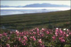
The climate of northern Greenland is arctic, and the lower soil layer is permanently frozen, called permafrost. Summer temperatures generally do not reach above 5°C in the high arctic region, and the north has a higher pressure system than the south, resulting in less precipitation. Rainfall decreases inland, and thus, arctic polar desert occurs near the ice cap in many places. Greenland experiences a few unusual meteorological phenomena, such the sudden and sometimes violent catabatic and föhn winds. Föhn winds are warm, dry air masses that blow from the ice cap to the coast and that are able to raise temperatures by 10-20°C, removing and melting snow. The coastal high arctic plant belt does not have willow scrub or herb slopes as in the south, but rather is covered in heath, fellfield, and snow patches. Plants must be very specifically adapted to the extreme climate of this region, being able to persist through dark winters, arctic temperatures, and low precipitation that primarily falls as snow. Many species have learned to adapt to the harsh environment, among them striking varieties of wildflowers such as sulphur-colored buttercup, alpine foxtail, and nodding lychnis. These examples are so well-adapted that they can not exist at warmer temperatures, and are generally absent from the low arctic tundra.
One to two million years ago, when climates were warmer, trees such as larch, black spruce, birch, yew, and thuja grew in the northernmost Peary Land. Paleo-ecological conditions were comparable to present day subarctic conditions of southernmost Greenland, except for differences resulting from the lack of sunlight in the north. Fossils show that the forest there was dominated by an extinct larch (Larix groenlandii), growing in conjunction with Picea mariana and Thuja occidentalis, none of which are present now.
The present vegetation of the high arctic tundra is sparse and not highly developed due to the brief and cold growing season and lack of water. Well-developed high arctic plant communities are concentrated on the east coast of Greenland, gradually becoming more sparse from south to north. Certain species or communities occur to the north only in association with hot springs, which are particularly numerous in the basalt areas on the central eastern coast. Examples of these species are Epilobium palustre and Platanthera hyperborea. The following details three latitudinal regions along the east coast: Jameson Land at the transition from low arctic to high arctic, the mid-coast from 72° – 79° N, and Peary Land at the northernmost extreme of Greenland as well as the world.
Jameson Land is located on the central east coast at the transition between low and high arctic tundra [[ecoregion]s]. This is the largest lowland area in Greenland, and is the most important habitat for muskox on the island. Up to 400 meters (m), the vegetation is dominated by dwarf scrub of Betula nana, Cassiope tetragona, and Vaccinium uliginosum. Moist protected sites have 75% plant cover, generally a heath rich in mosses. Inland about 10 kilometers (km) from the coast, snowbed vegetation of Carex bigelowii, Polygonum (Bistorta) viviparum, and Salix arctica occurs, interspersed with fens, lakes, and ponds. The dry, open dwarf-shrub heaths and fellfield vegetation of Arctostaphylos alpina, Dryas octopetala, Salix arctica, and Silene acaulis are crucial foraging areas for muskox in winter due to a sparse snow cover. The most luxuriant vegetation type in Jameson Land covers a very small area; these are herb slopes that have a thick snow cover in winter, but serve as important foraging areas for muskox in summer.
Using vegetation analyses from 1931-1935 with current analyses, categorize vegetation types of the eastern middle high arctic tundra from 72° – 79°N. Eight vegetation types are present: dwarf shrub heaths (dominated by Cassiope tetragona, Salix arctica, Vaccinium uliginosum ssp. microphyllum or Betula nana, depending on soil and duration of snow cover); grasslands, which dry out in summer (Arctagrostis latifolia, Carex bigelowii, C. misandra, and Eriophorum triste); permanently wet fens (Carex stans, Eriophorum scheuchzeri, and Arctagrostis latifolia); snowbeds (late ones characterized by Phippsia algida, the moderately late by Salix herbacea, and the few early herb slope-like snowbeds by Trisetum spicatum and Erigeron humilis); open, graminoid Dryas-heaths and fellfields on dry soil (Carex nardina, C. rupestris, and Kobresia myosuroides); fellfields (Calamagrostis purpurascens and Carex supina ssp. spaniocarpa); species-rich communities on wet ground that is covered by an organic crust (Koenigia islandica and Festuca hyperborea); and halophytic vegetation (Puccinellia phryganodes and Carex subspathacea).
In Peary Land, at the northernmost reaches of Greenland, vegetation covers only about 5% of the terrain. Annual precipitation is low at 25-200 millimeters (mm), all falling as snow, which is blown into drifts, leaving much of the land uncovered. Snow drifts are the only source of fresh water during the growing season, and the sparse vegetation communities occur in association with them. These are generally fens of Carex stans and Eriophorum spp., heaths of arctic bell heather (Cassiope tetragona), and snowbed vegetation of mosses. Large expanses have virtually no vegetation at all, especially at the interior and at higher altitudes. In some contrast, the coast of Peary land is moist and foggy, and stable ground has a dense cover of moss and lichens. This region can be considered in two floristic regions: [[coast]al] and dry interior. Coastal vegetation is Cassiope heath, fellfield, and mossy swamps. Dry interior communities are Dryas octopetala heath, steppe-like vegetation, and Carex stans meadow.
Biodiversity Features
Nine species of terrestrial mammals are native to Greenland: arctic hare (Lepus arcticus), arctic fox (Alopex lagopus - white and blue subspecies), arctic wolf (Canis lupus), caribou or reindeer (Rangifer tarandus), polar bear (Ursus maritimus), muskox (Ovibos moschatus), ermine (Mustela erminea), arctic hare (Lepus arcticus), and collared lemming (Dicrostonyx torquatus), and the wolverine (Gulo gulo). Aside from the polar bear, who is partially marine and has little trouble migrating, Greenland's larger mammals, including humans, reached the island from the northwest over winter ice. Several of these mammals could not cross the large glaciers of Melville Bay in the west, or the Blosseville Kyst on the East Coast, and are thus found only in the northern high arctic tundra region.
Almost all of Northeastern Greenland falls within the largest national park in the world. This region is a major breeding area for the muskox (Ovibos moschatus) and the threatened polar bear (Ursus maritimus). Marine mammals in the vicinity include Atlantic walrus (Odobenus rosmarus), bearded seal (Erignathus barbatu), harp seal (Pagophilus groenlandicus), ringed seal (Phoca hispida) along all the [[coast]s], and hooded seal (Cystophora cristata) in the southern fjords. Greenland’s high arctic serves as a breeding ground for many bird species during summer. These include great northern diver (Gavia immer), barnacle goose (Branta leucopsis), pink-footed goose (Anser brachyrhynchus), common eider (Somateria mollissima), king eider (S. spectabilis), gyrfalcon (Falco rusticolus), snowy owl (Nyctea scandiaca), sanderling (Calidris alba), knot (C. canutus), ptarmigan (Lagopus mutus), and raven (Corvus corax).
These föhn winds can be beneficial to large herbivores such as caribou and musk oxen when they expose vegetation in areas with less snow, such as the edge of the ice cap, or they can result in an ice crust if the snow melts superficially then refreezes, which can prove deadly if the crust is impenetrable and the spring thaw is far off.
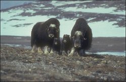
Forty percent of the world population of muskox live in the National Park of North and East Greenland. These creatures are often referred to as ice-age relics because they are the last surviving members of a large group of ice age "oxen" that is now extinct. In the same family as mountain goats and bighorn sheep (Bovidae), the muskox is the only High Arctic animal that does not seek shelter from arctic blizzards, being able to rely on its spectacular winter coat for protection. In the deep snow of winter, muskoxen will use their horns and feet to dig down to vegetation, forming large circular patches of cleared ground. These "food craters" are rigorously defended against other muskox. Muskoxen live in social groups that average 10-20 individuals. During the summer breeding season a dominant bull drives out other adult males from the group. Fights for dominance consist of threats, loud bellows, and repeated, high-speed head butting. Muskox herds display a specialized young protection behavior; when a herd is threatened by wolves, or humans, members of the group circle the young, facing the predators with their heads down. Larger adults may emerge from the circle trying to chase off the threat. Unfortunately, this specialized behavior made the muskox an easy target for hunters with dogs, which would chase the animals until they formed a circle, allowing the hunters to pick them off easily with rifles.
Two subspecies of muskox are commonly recognized, Ovibos moschatus moschatus in mainland Canada and O. m. wardi on the arctic islands of Canada and in Greenland. In 1935-1936, a small number of muskox from the Greenland O. m. wardi population was reintroduced on Nunivak Island, in Alaska, where they had long been extinct. The population grew over the years and supplied animals for other reintroduction efforts in northern Alaska from 1968 to 1981. Today, a population of about 2,300 muskox resides in Alaska, all derived from the Greenland stock.
Current Status
Human subsistence in Greenland has historically based on the exploitation of wildlife, and thus pressures are significant despite the low population, which was estimated at about 56,000 people in 2000. Many of the large mammals were hunted close to extinction during the 19th and early 20th centuries. In recent decades, Greenpeace's anti-sealing and anti-whaling campaign effectively destroyed Greenland's economic base, particularly in north Greenland where subsistence hunting embodied 80% of the income. Traditional subsistence hunting is now allowed under regulation, even within the national park. Animal populations have consistently been vulnerable to climatic changes. For example, the caribou disappeared from the national park in 1900 through migration to West Greenland in search of an adequate food supply; this, in turn, caused the arctic wolf to disappear by 1934 from the loss of its main source of food.
The vast National Park of North and East Greenland (1,000,000 km2) was established in 1974. Though only about forty people inhabit the permanent stations and airport within the park, many settlements are used during the summer in Peary Land and between Nordostrundingen to Scoresby Sund. Despite the continuation of hunting, the natural [[ecosystem]s] remain largely undisturbed, and there is sufficient surveillance staff for the large area. There are also three Ramsar sites designated within the High Arctic tundra region. Two are located within the national park: Hochstetter Forland, which contains an important moulting area for the pink-footed goose, and Kilen, which is an important breeding site for brent goose. The third is Heden, in Jameson Land, which is the largest tundra area in Greenland, and which is also an important staging area for geese and numerous species of breeding waterbirds. Hunting is allowed under regulation, and locals harvest natural resources seasonally. An oil exploration program has been active in Jameson Land since 1985; the primary detriment from this activity has been damage by vehicle traffic.
Types and Severity of Threats
The two primary threats faced by Greenland’s High Arctic tundra ecoregion are from oil exploitation and climate change. Oil exploration began in Greenland during the oil crisis of the 1970’s. By 1978, five wells had been drilled and declared dry, and activities were abandoned. Some further exploration is planned in Jameson Land. The primary threat from oil exploration or exploitation arises from increased human traffic and activities at drilling sites, particularly in onshore areas. If commercially viable oil deposits are discovered, these pressures will certainly increase significantly. Careful research and planning must be conducted to minimize habitat degradation.
Many studies suggest that global warming will significantly impact the climate of northern Greenland. This will undoubtedly result in many ecological impacts to the High Arctic tundra. It is expected that species with a more southerly distribution will spread northwards and out-compete the northerly-distributed species as the Arctic warms. However, species migration, of both plants and animals, will occur slowly, and will be preceded by an overall decrease in species [[population]s] and biodiversity. Specific conditions may have more immediate results. Repeated freezing and thawing of snow can result in a thick ice crust that prevents muskox and other grazers from reaching the vegetation beneath. This can lead to starvation for many animals. The timing of the spring thaw is critical to the arrival of migratory birds, which during the brief summer, rely on the abundance of insect and plant food resources. A delay in the thaw, caused by heavier winter snowfall, would at least delay the timing of breeding and at worst cause a reduction in bird populations. Being one of the remotest and least disturbed biomes, the Arctic is ideal for monitoring the impacts of climate change. It is in the Arctic, if anywhere, that one would expect to first see the ecological changes brought about by global warming.
Additional Information on this Ecoregion
- Appel, Peter W.U., Hugh R. Rollinson, and Jacques L.R. Touret. (2001) "Remnants of an Early Archaean (>3.75 Ga) sea-floor, hydrothermal system in the Isua Greenstone Belt." Precambrian Research, Vol. 112, Issues 1-2, 15 November, pp.27–49
- World Wildlife Fund. 2010. Kalaallit Nunaat high arctic tundra ecoregion
| Disclaimer: This article is contains information that was originally published by the World Wildlife Fund. Topic editors and authors for the Encyclopedia of Earth have edited its content and added new information. The use of information from the World Wildlife Fund should not be construed as support for or endorsement by that organization for any new information added by EoE personnel, or for any editing of the original content. |


