Ecoregions of Greenland
There are only two ecoregions of Greenland; these ecoregions exist entirely or in part in Greenland:
Ecoregions of Countries Collection 
Most of Greenland is actually covered by a permanent ice formation, the second largest such ice sheet on Earth, second only to the Antarctic Ice Sheet. No ecoregion designation is assigned to lands covered by ice sheets.
Greenland as a whole is an old shield geological region; Archaean rocks predominate the low Arctic ecoregion, though certain areas may be found covered by Tertiary basalts, such as Gunnbjørns Fjeld in the central eastern part of Greenland. The sea coastal zonei itself is chiefly rocky terrain, with some instances of steep cliffs consisting of granite and gneiss. The climate of Greenland is classified as Arctic, with the sole exception of the inner fjord region of the extreme southwestern coast.
Contents
Kalaallit Nunaat high Arctic tundra
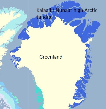
 Kalaallit Nunaat high Arctic tundra (in blue). Source: World Wildlife Fund The current flora of the Kalaallit Nunaat high Arctic tundra is sparse and not well developed due to the brief growing season, very cold climate and general paucity of water. Well-developed high arctic plant communities are concentrated on the east coast of Greenland, gradually becoming more sparse from south to north. Certain species or communities occur to the north only in association with hot springs, which are particularly numerous in the basalt areas on the central eastern coast. Representatives of these taxa are Epilobium palustre and Platanthera hyperborea. There are three latitudinal regions along the east coast: Jameson Land at the transition from low arctic to high arctic; the mid-coast from 72° to 79° N, and Peary Land at the northernmost extreme of Greenland as well as the terrestrial northern limit of the Earth.
Jameson Land is situated on the central east coast at the transition between low and high arctic tundra [[ecoregion]s]. This is the largest lowland portion of Greenland, and is the most significant habitat for muskox on Greenland. At elevations of up to 400 meters, the plantlife is dominated by dwarf scrub of Betula nana, Cassiope tetragona and Vaccinium uliginosum. Moist protected sites exhibit up to 75 percent plant cover, generally a heath abundant with mosses. Inland approximately ten kilometers from the coastal zone, snowbed vegetation of Carex bigelowii, Polygonum (Bistorta) viviparum, and Salix arctica occurs, interspersed with fens, lakes, and ponds. The dry, open dwarf-shrub heaths and fellfield vegetation of Arctostaphylos alpina, Dryas octopetala, Salix arctica, and Silene acaulis are crucial foraging areas for muskox in winter due to a sparse snow cover. The most luxuriant vegetation type in Jameson Land covers a small land area; these are typified by herb slopes manifesting a thick snow cover in winter, but serving as key foraging areas for muskox in summer.
In the eastern middle high arctic tundra from 72° to 79°N, eight vegetation types are present: dwarf shrub heaths (dominated by Cassiope tetragona, Salix arctica, Vaccinium uliginosum ssp. microphyllum or Betula nana, depending on soil and duration of snow cover); grasslands, which desiccate in summer (Arctagrostis latifolia, Carex bigelowii, C. misandra, and Eriophorum triste); permanently wet fens (Carex stans, Eriophorum scheuchzeri, and Arctagrostis latifolia); snowbeds (late ones characterized by Phippsia algida, the moderately late by Salix herbacea, and the few early herb slope-like snowbeds by Trisetum spicatum and Erigeron humilis); open, graminoid Dryas-heaths and fellfields on dry soil (Carex nardina, C. rupestris, and Kobresia myosuroides); fellfields (Calamagrostis purpurascens and Carex supina ssp. spaniocarpa); species-rich communities on wet ground that is covered by an organic crust (Koenigia islandica and Festuca hyperborea); and halophytic vegetation (Puccinellia phryganodes and Carex subspathacea).
Within Peary Land, at the northernmost limits of Greenland, vegetation covers only about five percent of the terrain. Annual precipitation is low at 25 to 200 millimeters, enitrely occurring as snow, which is typically blown into drifts, leaving much of the land uncovered. Snow drifts are the only source of freshwater during the growing season, and the sparse vegetation communities occur in association with these water resources. These locales fed by snowmelt are generally fens of Carex stans and Eriophorum spp., heaths of arctic bell heather (Cassiope tetragona), and snowbed mossy vegetation. Large expanses of the land surface have virtually no macro-vegetation at all, especially at the interior, as well as at higher altitudes. In some contrast, the coastal zone of Peary land is moist and foggy, and stable ground has a dense cover of moss and lichens. This region can be considered in two floristic regions: [[coast]al] and dry interior. Coastal vegetation is Cassiope heath, fellfield, and mossy swamps. Dry interior communities are characteristically Dryas octopetala heath, steppe-like vegetation, and Carex stans meadow.
Kalaallit Nunaat low Arctic tundra
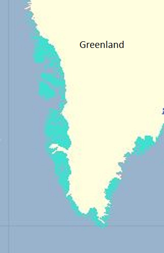
 Kalaallit Nunaat low Arctic tundra (in turqoise), Source: World Wildlife Fund The Kalaallit Nunaat low Arctic tundra is found in the southern part of Greenland. Here scattered tree species are typically dwarf versions of their ancestors. Vascular flora of Greenland is poor (at around 500 species), even compared to that of the northern coast of Alaska or to Norway above the timber line. Owing to the cold temperatures and many months of ice cover, sheltered ecosystems have little chance to develop in most areas, and with the majority of the easily characterized coastal ecosystems in Greenland occurring in this low arctic ecoregion. Some regions closest to the ice-cap are actually the driest, such as along the west coast, which exhibits a dwarf-scrub heath and steppe-like vegetation. At the head of fjords where the climate is warmer subarctic, sheltered areas support scrub and low forests composed of Alnus crispa, Betula pubescens, and Sorbus groenlandica. Montane areas may have distributions of more southerly species scattered in sheltered spots. Within the southernmost portion of Greenland, where the climate is warmest, stunted birch forests cover less than fifteen percent of land area. The birches (Betula spp.) are generally 0.5 to 2.0 metres tall, although trees as tall as ten metres can more rarely occur. This area is dominated by dwarf-scrub heath (42%), with significant areas of dry meadow (18%) and lichen heath (12%).
The Søndre Strømfjord region extends along the west coast of Greenland, where ice-free land reaches farthest inland, exhibiting the most pronounced gradient from maritime to continental vegetation. Contrasted to the exposed coastal zone, the climate inland has less precipitation, briefer duration of snow-cover, warmer summer temperatures and colder winter temperatures. The vegetation transitions from grassy meadows and rich dwarf-shrub at the coast, to prairie and steppe with occasional salt pans and salt lakes in the interior. Heaths are dominated by Empetrum hermaphroditium toward the coast and Betula and Dryas spp. inland; snow-beds of Salix herbacea and herb slopes Potentilla crantzii are found on the coast; Salix glauca scrub and Carex supina steppe are found inland. At the head of the sound, where the climate would be expected to be subarctic, rainfall is actually too scant for large trees to thrive, so that the most well developed plantlife is willow scrub, which attains heights of four to five metres, but only along watercourses. Overgrazing has transformed much of this Salix glauca scrub to dense grasslands of Poa pratensis.
Definition of an ecoregion
An ecoregion is established to be a geographical region that:
[1] Shares a large majority of their species and ecological dynamics;
[2] Shares similar environmental conditions; and,
[3] Interacts ecologically in ways that are critical for their long-term persistence.
Scientists at the World Wildlife Fund, have established a classification system that divides the world in 867 terrestrial ecoregions, 426 freshwater ecoregions and 229 marine ecoregions that reflect the distribution of a broad range of fauna and flora across the entire Earth.
References
 Appel, Peter W.U., Hugh R. Rollinson, and Jacques L.R. Touret. (2001) "Remnants of an Early Archaean (>3.75 Ga) sea-floor, hydrothermal system in the Isua Greenstone Belt." Precambrian Research, Vol. 112, Issues 1-2, 15 November, pp.27–49
- World Wildlife Fund. 2010. Kalaallit Nunaat high arctic tundra ecoregion
- C.Berthelsen, I.H.Mortensen and E.Mortensen. 1993. Atuakkiorfik, Greenland.
- Bliss, L.C. and N.V. Matveyeva. 1992. Circumpolar Arctic Vegetation. Pages 59-90 in F. S. I. Chapin, R.L. Jefferies, J.F. Reynolds, G.R. Shaver, J. Svoboda, E.W., and Chu, editors. Arctic ecosystems in a changing climate: an ecophysiological perspective. Academic Press, Inc., San Diego, CA. ISBN: 0121682501
- Böcher, J. and P.M. Petersen. 1997. Greenland. Pages 685-720 in Ecosystems of the World; Polar and Alpine Tundra. ISBN: 0444882650
- Daniëls, F.J.A. and J.G. De Molenaar. 1993. Ecosystems of the World.
