Coalfire and remote sensing
Contents
- 1 The Problem
- 2 Spontaneous Combustion of Coal
- 3 Detecting and Monitoring Coalfires Using Remote Sensing
- 4 Coalfires in the Americas
- 5 Coalfires in Asia and Pacific Region
- 6 Coalfires in Europe
- 7 Coalfires in Africa
- 8 Conclusions Coalfires (Coalfire and remote sensing) are a widespread problem in most coal-producing countries. Remote sensing can play a significant role in the detection and monitoring of coalfires, which may prevent huge economic losses and environmental disasters. In such developing countries as China (Energy profile of China) and India (Energy profile of India), coal is the most available and economic energy source. To ensure the appropriate and efficient use of this prime and nonrenewable energy resource, better planning and management are required, with a special emphasis on environmental rehabilitation for sustainable development. Although methods for coalfire detection and monitoring that are based on remote sensing are well established, such constraints as pixel integrated temperature (with respect to spatial resolution) and acquisition time, need to be considered much more cautiously.
- 9 Further Reading
The Problem
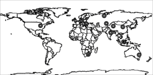 Figure 1. Occurrence of coalfires worldwide. (Source: Author)
 Coal is the prime energy resource in most countries. Although coal deposits are distributed widely, 60% of the world’s recoverable reserves are located in three countries: the United States (Energy profile of the United States), the former Soviet Union, and China (Energy profile of China). Other than these three countries, Australia (Energy profile of Australia), India (Energy profile of India), Germany (Energy profile of Germany), and South Africa also produce a significant amount of coal. Subsurface and surface coalfires are a serious problem in many coal-producing countries. One of the earliest coalfires was revealed by Goldammer and Seibert, using the thermoluminescence of baked rocks close to a coal seam in East Kalimantan. They dated it to approximately 13,000 years ago.
Combustion can occur within coal seams (underground or surface), in piles of stored coal, or in spoil dumps at the surface. The fires in coal seams can be initiated spontaneously under certain conditions, where air, heat (from sun), and water[vapor] are the main constituents. Also, lightning and forest/bush fire can initiate a coalfire. In some cases, human negligence, a mine accident, or a human-induced heat source could be the reason for a coalfire. Coalfires are common in regions of many coal-producing countries, such as China, India, Indonesia (Energy profile of Indonesia), the United States, Australia, South Africa, and Russia (Energy profile of Russia) (Fig. 1).
Several direct and indirect environmental problems are associated with coalfires. Some of the prime impacts of coalfires are:
- Emission of several toxic gases, such as carbon monoxide (CO), carbon dioxide (CO2), nitrogen oxides (NOx), sulfur oxides (SOx), and methane (CH4). Among these noxious gases, CO2 and CH4 contribute to global warming.
- Land subsidence, that leads to a change in the local drainage pattern.
- Temperature increment of surrounding areas.
- Increment of production cost due to fire extinguishing and difficulties in mining operations.
Spontaneous Combustion of Coal
Coal, the most used fossil fuel, is a readily combustible rock that contains more than 50%, by weight, of carbonaceous material, and is formed by the compaction and induration of variously altered organic remains. Unpredictable amounts of other chemicals (e.g., sulfur, chlorine, sodium) and other minerals can be found in coal. According to its increasing amount of carbon, types of coal are classified as lignite, sub-bituminous coal, bituminous coal, or anthracite. Rank is another index of coal quality. This is a measure of the brightness (reflectivity) of the coal as measured microscopically, and is a function of the vitrinite content one of the microlithotypes in coal.
Combustion of coal is a chemical process that can be defined in a simplified form as:
- Coal + O2 → CO2 + Energy, (1)
Practically, the process is, in fact, more complicated and may consist of different stages, that also depend on the presence of other substances (e.g., water vapor, and pyrite). Several other factors can accelerate or decrease the speed of the reactions (e.g., oxygen content of air, exposed surface area of the coal, temperature, and composition of coal).
The potential for coal to ignite spontaneous combustion depends on its aptitude of oxidization at ambient temperature under certain conditions (Fig. 2). This occurs through the absorption of oxygen at the surface of the coal, and is an exothermic reaction. The temperature of the coal may start to increase. If the temperature reaches what often is called the “threshold” temperature somewhere between 80 °C and 120 °C a steady reaction results in the production of such gaseous products as CO2. The temperature of the coal almost certainly will continue to increase until, somewhere between 230 °C and 280 °C, the reaction becomes rapid and strongly exothermic (i.e., the coal reaches “ignition” or a “flash” point and starts to burn).
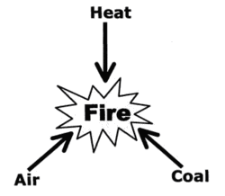 Figure 2. The main components of a coalfire. (Source: Author)
 Not all types of coal are equally susceptible to spontaneous combustion. High-ranking coals (that is, having high carbon content) are more fire prone than lower-ranking coals; however, the exact reasons are unclear. Another important factor is the size of the particles; the larger the effective area of the coal (fine particles), the more rapidly the reaction can proceed.
Also, external factors play a role in the oxidation reaction. Oxidation requires an adequate supply of air; cracks, fissures, and the porosity of rock and soil over the coal seams may encourage underground coalfires by allowing oxygen to reach the coal. In addition, the presence of water (vapor) has some important effects. Coal with very high or very low moisture content tends to exhibit a low oxidation rate. A minimum amount of water is considered necessary, however, for the reaction to continue.
Depending on the influencing factors, a coalfire can initiate in an outcrop of coal seams at the surface. Rosema et al. defined an open coalfire as one that burns in direct contact with the atmosphere, usually with visible flames. Other than in exposed seams of coal, fire can occur in stockpiles or spoil dumps. In the case of a subsurface coalfire, the required oxygen enters through cracks or fissures at the surface or mine shafts. However, the coalfire can cause subsidence as it voids the support (coal seam) beneath any overburden rock and make sufficient passage for breathing to continue combustion.
Detecting and Monitoring Coalfires Using Remote Sensing
It is obvious that a surface coalfire can be detected easily; however, a subsurface coalfire can burn over time without any surface activity. Before the introduction of remote sensing for the study of coalfires, borehole measurement was one of the popular methods that was used to identify coalfires. Although this method can be used to measure the temperature of a coal seam that is suspected to be affected by fire very accurately, it is not feasible for use over a large area.
Despite the fact that remote sensing already was being used for earth observation, in the early 1960s it was used first for a coalfire study with an airborne thermal scanner. With time the technology and quality of thermal remote sensing has improved and so has its practice and performance. Also, some established geophysical methods are used for coalfire study.
Satellite-based remote sensing begun in the 1960s, but it was not accessible to civilians until 1972. With time, remote sensing has evolved dramatically. In passive visible near infrared (VNIR) or shortwave infrared (SWIR) remote sensing involves mainly three components: energy source (the sun), reflecting surface (earth’s surface) and receiver (sensor). In thermal remote sensing, the surface itself emits energy in particular wavelengths that is recorded by sensor.
The 3 μm to 14 μm region of the electromagnetic spectrum (EMS) is referred to as the thermal infrared region. Thermal remote sensing uses atmospheric windows in the 3 μm to 5 μm and 8 μm to 14 μm regions only, because these parts of the EMS are not affected as much by atmospheric interaction.
Thermal-infrared sensing exploits the fact that everything above absolute zero (0 °K or -273 °C) emits radiation in the thermal infrared range of the EMS. The thermal infrared radiation of an object is controlled mainly by its emissivity, surface geometry, and temperature. Thermal infrared sensors record differences in the received infrared radiation from various objects.
Many commercial and research scanners (both air- and satellite-borne) are acquiring data in the thermal infrared region (3-5 μm and 8-14 μm) all over the world. Numerous thermal airborne scanners (e.g., Daedalus μm, USA, TIMS μm, USA, ARIES [France], Digital Thermal Linescanner μm, UK, TABI-320 μm, Canada, OMIS1 μm, China) and several other thermal scanners are operating in different countries with many applications, such as coal/forest/bush fire detection and monitoring, surveillance, and reconnaissance.
Airborne operations are not as cost effective as are satellite-based operations for monitoring a broad area. Satellite-based earth observation thermal scanners operate from two types of platforms: polar orbiting and geostationary. Among the polar-orbiting satellites, Landsat7 ETM+ band 6 (presently non-functional because of scanner failure) and ASTER band10 to band14 are commonly used. For a large area, the AVHRR instrument (on the NOAA (National Oceanic and Atmospheric Administration (NOAA), United States) series of polar-orbiting satellites) is recording the earth’s surface thermally with a spatial resolution of 1.1 km. MODIS (NASA) is acquiring data in the thermal infrared region (spatial resolution 1 km), which are being used in many applications in meteorology and earth observation. Many geostationary satellites, such as GOES (NASA), Eumetsat and Meteosat (ESA), INSAT (India), GOMS (Russia), GMS (Japan), and FENG-YUN (China), are gathering data about cloud-top temperature for weather prediction. also, some of these satellites are being used for forest fire monitoring because of their very high temporal resolution.
When present as flaming combustion on the surface, coalfires emit significant thermal energy that is easy to detect by any thermal remote sensing scanner. However, the surface heating is comparatively subdued with a subsurface coalfire, and may be masked by daytime solar heating. In that case it is necessary to use nighttime remote sensing data to reveal and measure the extent of heating. There are three steps in the use of remote sensing to detect a coalfire:
- Acquisition of a thermal image (preferably at night) of the area under investigation using remote sensing and processed digitally to create a surface temperature map to reveal the temperature anomalies,
- Acquisition of information about the local geological setting, [[temperature]s] of coalfire vents, and different land cover types through field survey,
- Use of the geological and other field knowledge to eliminate anomalies, other than coalfires, to produce a final temperature map that is calibrated with temperatures that were collected in the field.
The atmosphere between the object (coalfire) and the receiver (remote sensor) plays a significant role in the accuracy of the surface temperature estimation, especially in quantitative studies. The temperature of the surface over a coalfire depends on several factors: inherent properties (emissivity; fire temperature) and the conditions of the surrounding areas (soil type; topography; local atmosphere; crack or fissures on the surface; and depth of fire). Also, the thermal properties of rock are significant factors in thermal remote sensing. For example, some high thermal inertia rocks can appear as coalfires in nighttime images because they trap the heat longer compared with other rocks. However, pre-dawn data acquisition and a good knowledge of the local geological setting can exclude these false anomalies.
Coalfires in the Americas
Coal mining started in Pennsylvania mainly to make coke for iron smelting. The first coalfire was reported in 1772; in 1869, it turned into a major disaster and claimed the lives of many miners (Glover, 1998; Stracher and Taylor, 2004). In 1962, the U.S. Bureau of Mines reported 223 coalfires all over the United States. The United States was the first country to apply remote sensing to coalfire detection. Using the “Reconofax” thermal scanner on an airborne platform, Slavecki, Fisher and Knuth, and Greene et al. studied fires on waste coal and subsurface coalfires in Pennsylvania, the state where coalfire remains a serious problem. Greene et al. also studied the depth of fire, and they classified fires into three types according to their depth, e.g. shallow, intermediate and deep fires.
There are several incidences of coalfires in Canada (Energy profile of Canada), Venezuela (Energy profile of Venezuela) and Argentina (Energy profile of Argentina). However, no open scientific documents exist that confirm coalfire study using remote sensing in these countries.
Coalfires in Asia and Pacific Region
 Figure 3. Smoke coming out from a crack in Raniganj. (Source: Author)
 India: In India (Energy profile of India), the main two coal producing regions are Raniganj and Jharia. Surface and subsurface coalfires are common in both areas (Fig. 3). Aided by remote sensing, many researchers, such as Bhattacharya et al., Cracknell and Mansor, Reddy et al., Saraf et al., Prakash et al. and Gangopadhyay et al. have studied the coalfires in Raniganj and Jharia. They mainly used airborne pre-dawn thermal infrared and daytime multispectral satellite remote sensing images to distinguish the coalfires from the background. Also, daytime thermal images (of Landsat and NOAA (National Oceanic and Atmospheric Administration (NOAA), United States) satellites) were used to detect coalfires in these mining areas.
 Figure 4. Cracked surface in a mining region in north China. (Source: Author)
 China: It is estimated that up to 200 million tons of high-quality coal are lost every year, mostly in the northern half of China (Energy profile of China) (Fig. 4). Since 1986, several researchers have worked on coalfires in Xinjinag, Ningxia Hui and Wuda regions. Most of the studies here are based on pre-dawn airborne thermal scanner and Landsat thermal band data. In 1991, Huang et al. studied the extent of coalfires using Daedalus (an airborne sensor) data, and presented an alarming picture of Chinese coalfires. In China, several scientists have approached different methods for better understandings of coalfire, e.g. solar heating effect elimination (from daytime image), sub pixel temperature estimation (to identify smaller files), spectra analysis of rocks (to identify coalfire-related burnt rocks) and satellite-derived emissivity extraction (for more accurate surface temperature estimation).
Australia: Although Burning Mountain in Australia (Energy profile of Australia) has been known for a long time, the first recorded observation was in 1828 after its discovery by a local farmer. A notable study was produced by Fleming, which suggested that the fires could have been burning since the Pleistocene. Later, Ellyett and Fleming did an extensive study using a Daedalus thermal airborne scanner that operates in the 8-μm to 14-μm region. Today, that fire is more than 152 meters underground, and is still burning the coal slowly. Fires also occur spontaneously in opencast coal mines in many locations, such as Hunter Valley (New South Wales) and the lignite mines in Victoria and South Australia.
Indonesia: Slash and burn (forest clearing by fire) is a popular and easy method by which to claim cultivation land from forests in Kalimantan (Borneo) of Indonesia (Energy profile of Indonesia); these fires sometimes burn out of control and ignite the coal seams that are exposed nearby. In East Kalimantan, baked rocks were found close to a coal seam, which could be evidence of an ancient coalfire. The existence of coalfires in southern Sumatra also is familiar to the community that researches coalfires. It has been assumed that these ancient coalfires were ignited by lightning. A combination of forest fire, frequent lightning, and warm climate create a favorable situation for spontaneous combustion in coal. A recent study by Whitehouse and Mulyana estimated that between 760 and 3000 coalfires are burning in east Kalimantan.
Russia and the former Soviet Union States: In Russia (Energy profile of Russia), other than spontaneous combustion, some coalfires are initiated by explosion of trapped methane and human errors. In 1998, 74 coalfires were reported in Russia. Kyrgyzstan, a former USSR state, also has been stricken by coalfires, which is evident in the Issyk-Kul region. However, no open literature is available that reports on the application of remote sensing to the detection and monitoring of coalfires in Russia and the former Soviet Union states.
Coalfires in Europe
The occurrence of coalfires in mines and stockpiles in many coal-producing countries, such as Germany (Energy profile of Germany), Poland, Bulgaria and Romania, have been reported by different researchers. In addition, some coal seam fires were reported by Walker near the Poland–Czech Republic border. One of the biggest coalfire–related accidents in Serbian (then Yugoslavia) mining history happened in 1989 and claimed 92 lives. This coalfire was initiated by a trapped methane explosion that took a long time to extinguish. Coalfire is a known phenomenon in Ukrainian coal mines. One of the biggest coalfire–related accidents claimed 33 lives in recent years. A very recent (in 2005) coalfire has been reported in the Svea Nord mine on the Arctic island of Spitsbergen, off Norway (Energy profile of Norway), that was initiated by human negligence. The fire had a width of 1 km and took several weeks to extinguish. An unconfirmed Internet-based source reports about the use of a thermal (airborne) scanner in Germany (Energy profile of Germany) for monitoring (stockpile) coalfires, but there is no reviewed report available.
Coalfires in Africa
The occurrence of fires in South African underground coal mines was observed for a long time. In addition to South Africa, there are some web-based reports about stockpile or spoil dump fires in Zimbabwe, Botswana, Mozambique, and Zambia. An underground coalfire in one of the Anglo coalmines had been burning for the last few years, but was extinguished recently.
Conclusions Coalfires (Coalfire and remote sensing) are a widespread problem in most coal-producing countries. Remote sensing can play a significant role in the detection and monitoring of coalfires, which may prevent huge economic losses and environmental disasters. In such developing countries as China (Energy profile of China) and India (Energy profile of India), coal is the most available and economic energy source. To ensure the appropriate and efficient use of this prime and nonrenewable energy resource, better planning and management are required, with a special emphasis on environmental rehabilitation for sustainable development. Although methods for coalfire detection and monitoring that are based on remote sensing are well established, such constraints as pixel integrated temperature (with respect to spatial resolution) and acquisition time, need to be considered much more cautiously.
Further Reading
- Banerjee, S.C., 1985, Spontaneous Combustion of Coal and Mine Fires. A.A. Balekema, Rotterdam, p. 18. ISBN: 9061915740
- Bhattacharya, A., Reddy, C.S., and Mukherjee, T., 1991, Multi-tier remote sensing data analysis for coalfire mapping in Jharia coalfield of Bihar, India. In Proceedings, Asian Conference on Remote Sensing, Singapore, 12th, National University of Singapore, p. 22-1-22-6.
- Bustin, R.M. and Mathews, W.H., 1982, In situ gasification of coal, a natural example: history, petrology, and mechanics of combustion. Canadian Journal of Earth Sciences, 19:514-23.
- Bustin, R.M. and Mathews, W.H., 1985, In situ gasification of coal, a natural example: additional data on the Aldridge Creek coalfire, southeastern British Columbia. Canadian Journal of Earth Sciences, 22:1858-64.
- Cracknell, A.P. and Mansor, S.B., 1992, Detection off sub-surface coalfires using Landsat Thematic Mapper data. International Archives of Photogrammetry and Remote Sensing, 29(B7):750-753.
- Ellyett, C.D. and Fleming, A.W., 1974, Thermal infrared imagery of the Burning Mountain coalfire. Remote Sensing of Environment, 3:79-86.
- Fisher, W.J. and Knuth, W.M., 1968, Detection and delineation of subsurface coalfires by aerial infrared scanning. Geological Society of America Bulletin, 115:67–68.
- Fleming, A.W., 1972, Investigations into Permian Geology and The Burning Mountain Coalfire Thesis: Newcastle, University of Newcastle.
- Gangopadhyay, P.K., Lahiri-Dutt. K., Saha. K., 2006, Application of Remote Sensing to Identify Coalfires in the Raniganj Coalbelt, India. International Journal of Applied Earth Observation and Geoinformation, 8:188–195.
- Gangopadhyay, P.K., Maathuis, B., van Dijk, P., 2005a, ASTER derived emissivity and coalfire related surface temperature anomaly: A case study in Wuda, North China. International Journal of Remote Sensing, 26(24):5555-5751.
- Glover, L., 1998, Underground Mine Fires Sparks Residents’ Fear. Tribune Review, Greensburg, PA, A-1, A-10.
- Goldammer J.G. and Seibert, B., 1989, Natural rain forest fires in Eastern Borneo during the Pleistocene and Holocene. Naturwissenschaften, 76:518-520.
- Greene G.W., Moxham, R.M. and Harvey, A.H., 1969, Aerial infrared surveys and borehole temperature measurements of coal mine fires in Pennsylvania. In Proceedings, International ERIM Symposium on Remote Sensing of Environment, Sixth, University of Michigan, p. 517-525.
- Huang, Y., Huang, H. and Chen, W., 1991, Remote sensing approaches for underground coalfire detection. In Proceedings, Beijing International Conference on Reducing Geological Hazards, Beijing, p. 634-641.
- Kooij, M., 2005, Liberty Gasturbine Holland, the Netherlands: Personal correspondence.
- Lillesand T.M and Kiefer R.W, 2000, Remote Sensing and Image Interpretation, Fourth Edition. John Wiley and Sons Inc., p. 6. ISBN: 0471152277
- Maathuis, B., 2005, ITC, the Netherlands: Personal correspondence.
- Prakash, A., Gupta, R.P. and Saraf A.K., 1997, A Landsat TM based comparative study of surface and subsurface fires in the Jharia coalfield, India. International Journal of Remote Sensing, 18(11):2463-2469.
- Reddy, C.S.S., Srivastav, S.K. and Bhattacharya, A., 1993, Application of Thematic Mapper short wavelength infrared data for the detection and monitoring of high temperature related geoenvironmental features. International Journal of Remote Sensing, 14:3125-3132.
- Rosema, A., Guan, H., Veld, H., Vekerdy, Z. Ten Katen, A.M. and Prakash, A., 1999, Manual of Coalfire Detection and Monitoring. Utrecht, Netherlands Institute of Applied Geosciences, NITG Publications, p. 245.
- Saraf A.K., Prakash, A., Sengupta, S. and Gupta, R.P., 1995, Landsat TM data for estimating ground temperature and depth of subsurface coalfire in the Jharia coalfield, India. International Journal for Remote Sensing, 16:2114-2124.
- Schmal, D., 1987, A model for the spontaneous heating of stored coal Thesis. Delft, The Netherlands, Technology University of Delft.
- Sinha, P.R., 1986, Mine Fires in Indian Coalfields. Energy, 11-12:1147-1154.
- Slavecki, R.J., 1964, Detection and location of subsurface coalfires. In Proceedings, Symposium on Remote Sensing of Environment, 3rd, Ann Arbor: Michigan, University of Michigan, p. 537-547.
- Stracher, G.B. and Taylor, P. T., 2004, Coalfires burning out of control around the world: thermodynamic recipe for environmental catastrophe. International Journal of Coal Geology, 59:7-17.
- Tetuko, S.S. J., Tateishi, R. and Takeuchi, N., 2003, A physical method to analyse scattered waves from burnt coal seam and its application to estimate thickness of fire scars in central Borneo using L-Band SAR data. International Journal of Remote Sensing, 24(15):3119-3136.
- van Genderen, J.L., Cassells, C.J.S. and Zhang X.M., 1996, The synergistic use of remotely sensed data for the detection of underground coalfires. International Archives of Phtogrammetry and Remote Sensing, XXXI(7):722-727.
- Walker, S., 1999, Uncontrolled fires in coal and coal wastes. London, International Energy Agency, 73 pp. ISBN: 9290293241
- Wan, Y.Q. and Zhang X.M., 1996, Using a DEM to reduce the effect of solar heating on Landsat TM thermal IR images and detection of coalfires. Asia-Pacific Remote Sensing and GIS Journal, 8:65-72.
- Whitehouse, A.E. and Mulyana, A.A.S., 2004, Coalfires in Indonesia. International Journal of Coal Geology, 59:91–97.
- Williams, D.J., 2005, Energy Technology, CSIRO, Australia: Personal correspondence.
- Zhang, X.M., Genderen J.L. van and Kroonenberg S.B., 1997, A method to evaluate the capability of landsat-5 TM band 6 data for sub-pixel coalfire detection. International Journal of Remote Sensing, 18:3279-3288.
- Zhang, J.Z., 1996, SWIR spectra of rocks in areas affected by coalfires, Xinjinag autonomous region P.R. of China Thesis: Enschede, 74 pp.