Water profile of Myanmar
Contents
Geography and Population
Myanmar has a total area of 676,580 square kilometers (km2). It is situated at the juncture of the Indian subcontinent and southeast Asia. The country is divided into seven states, mainly covering the hill regions, and seven divisions covering the plains.
Topographically, the country can be divided into five regions. They are the northern and western mountains, the eastern plateau (Shan plateau), the central basin and the coastal strip. The country is mountainous, rising to more than 5,800 meters (m) above sea level in the far north, reaching an elevation of well over 2,000 m over much of Shan state in the northeast, and in Rakhine and Chin states in the west.
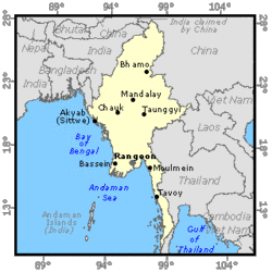 Map of Myanmar. (Source: FAO)
 The cultivable area is estimated at 18.27 million hectares (ha), while the cultivated area amounts to 10.14 million ha, or 55 percent of the cultivable area. The cultivated area can be divided into fallow area (14 percent), net sown area (66 percent) and multiple cropping area (20 percent). The cultivated areas are concentrated in the Ayeyarwady River basin, while potential for further expansion lies mainly in upper Myanmar, namely in the Chin, Kachin and Shan states.
In 1996, the total population was estimated by the UN at 45.922 million inhabitants (74 percent rural). With a population density of 68 inhabitants/km2, Myanmar is well below the level of other countries in south and southeast Asia. The population growth rate is estimated at 1.87 percent. About 72 percent of the total labor force is engaged in agriculture, and 70 percent in the primary sector, including livestock, fisheries, and forestry. The agriculture sector contributes 50 percent of Gross Domestic Product (GDP), and generated 33 percent of total export earnings in 1994.
Climate and Water Resources
Climate
Myanmar's climate is tropical monsoonal in type. Rainfall is highly seasonal, being concentrated in the hot humid months of the southwest monsoon (May to October). By contrast, the northwest monsoon (December to March) is relatively cool and almost entirely dry.
The mean annual rainfall is estimated at 2,341 millimeters (mm). The most significant regional variations are those associated with the intensity of the southwest monsoon rains. Annual rainfall ranges from as high as 4,000-6,000 mm along the coastal reaches and in the mountains of Rakhine and Tanintharyi to as low as 500-1,000 mm in the central dry zone. Intermediate levels of rainfall characterize the Ayeyarwady Delta areas (2,000-3,000 mm/year), the Shan plateau (1,000-2,000 mm/year) and the transitional areas. As with the rainfall, 90 percent of the discharge flows between May and October.
River Basins and Water Resources
The north-south direction of Myanmar's mountain ranges is reflected in the flow of its major rivers, of which two are international rivers. There are six river basins:
- the Ayeyarwady and Chindwin river basin, which is almost entirely located in Myanmar and drains 58 percent of the territory;
- the Sittoung River basin, which is also entirely located in Myanmar to the east of the Ayeyarwady, drains 5.4 percent of the territory;
- the Thanlwin (Salween) River basin, which drains 18.4 percent of the territory, mainly the Shan plateau in the east of the country. The river comes from China and after entering the country forms the border with Thailand for about 110 kilometers (km);
- the Mekong River basin, which drains 4.2 percent of the territory in the far east and forms the border with Lao PDR. The Mekong River has 2 percent of its catchment area in Myanmar. Myanmar is not a member of the Mekong River Commission;
- the Rakhine (Arakan) coastal basin in the west draining into the Bay of Bengal;
- the Tanintharyi (Tenasserim) coastal basin in the south draining into the Andaman Sea.
 Table 1. Average annual river runoff in Myanmar. (Source: Government of Myanmar/FAO)
 The inflow from other countries is estimated at 128.2 km3/year from Chinese and Thai information and includes: 20 km3/year from India, 68.7 km3/year (Yuan Yiang) and 31.3 km3/year (Lancang) from China, and 8.2 km3/year from Thailand. The total surface water produced internally (total runoff minus inflow from other countries) is estimated at 874.6 km3/year. Groundwater resources have been estimated at 156 km3/year but a large part of this water (estimated at 150 km3/year) constitutes the base flow of the rivers and is also accounted for as surface runoff.
The Mekong River forms the border with Lao PDR over 170 km, from which 36.815 km3/year can theoretically be considered as an additional external resource. The total natural renewable water resources (including flow from incoming or border rivers) are estimated at 1,045.6 km3/year.
Lakes and Dams
There are few lakes in Myanmar. The largest is Lake Inle which covers an area of 155 km2. In 1994, there were 70 dams over 15 m high.
The theoretical hydropower potential has been estimated at more than 100,000 megawatts (MW), of which 9,000 MW with detailed feasibility studies. In 1995, 288 MW had been developed, which represented at that time 34 percent of the total installed power capacity of the country.
Water Withdrawal
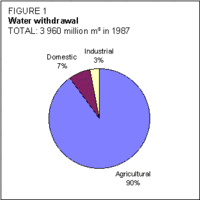 Figure 1. Water withdrawal. (Source: FAO)
 Water withdrawal was estimated at 4 km3/year in 1987, of which 90 percent for irrigation purposes (Figure 1).
About 46 percent of the population have access to adequate protected water supplies. Extreme conditions persist in the coastal and delta regions where overall coverage rates are 10-13 percent. There is no wastewater treatment in Myanmar.
Irrigation and Drainage Development
Because of the rainfall and hydrological pattern of the country, the need for irrigation is highest in the central dry zone, while the delta is more concerned with drainage and flood protection problems.
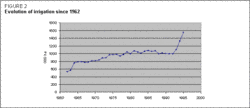 Figure 2. Evolution of irrigation since 1962. (Source: FAO)
 It is thus logical that the first irrigation works should have been undertaken near Bagan (Pagan) in the central region in the eleventh and twelfth centuries. They typically comprised diversion systems based on tributaries of the middle Ayeyarwady, and were designed essentially to provide security to the main season paddy crop. Storage reservoirs were also constructed for the same purpose. The ancient systems were subsequently modernized, extended, and operated in the traditional manner, with a greater emphasis on the upgrading and development of the existing flood protection and drainage facilities in the Ayeyarwady Delta. This enabled the development of paddy cultivation and made Myanmar a major rice-exporting country before World War II. Dam construction and irrigation network implementation were significantly accelerated in the 1960s, 1970s, and after 1990 (Figure 2). The irrigation potential is estimated at 10.5 million ha, considering both water and soil resources.
The irrigated areas are estimated at 1,555,416 ha. Irrigation expansion has been significant (up 50 percent) in the last five years.
Irrigated areas were traditionally supplied through weirs for river diversion or dams and tanks, but wells and pumping in rivers have developed quite substantially in recent years (Figure 3). Pump irrigation was promoted in the 1980s by programs implemented by the Agricultural Mechanization Department. Other types of irrigation water supply include windmills, watermills, watering with buckets, ponds, etc.
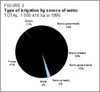 Figure 3. Type of irrigation by source of water (Source: FAO)
 All irrigation in Myanmar is surface irrigation. Sprinkler and localized irrigation have been developed only on pilot farms, and altogether do not exceed 50 ha.
Two types of irrigation management coexist in Myanmar: public and private schemes. Government schemes account for 53 percent of weir schemes and 81 percent of the dams and tanks (all dams of and above 6.1 m). Wells and pump irrigation, although possibly originally implemented by the services of the Ministry of Agriculture, are mainly private.
Although farmers are responsible for implementation, management, and operation and maintenance (O&M) in the private schemes, both the Irrigation Department and the Water Resources Utilization Department provide technical and financial assistance. The main irrigated crops are paddy, oil crops, and fiber crops (Figure 4).
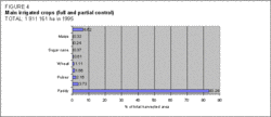 Figure 4. Main irrigated crops (full and partial control). (Source: FAO)
 There are important groundwater aquifers in Myanmar. However, their exploitation has been limited to domestic water supply and to the intensive irrigation of vegetables and other high value crops from hand-dug wells. In the central dry zone, where most of the potential for economical run-of-the-river diversion schemes has been utilized, dams, irrigation projects and groundwater irrigation projects were started in the 1980s. Irrigation from groundwater was practiced on 55,175 ha in 1995, mainly for cotton, wheat, beans, and pulses. Groundwater is mobilized mainly by diesel pumps (Figure 5). Generally, one tube-well allows supplementary irrigation on 4 ha. Since the development of tube-well irrigation in 1992, 3,000 tube-wells have been drilled every year by the Department of Water Resources Utilization. Following this example, the private sector drills around 9,000 tube-wells each year.
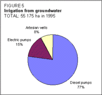 Figure 5. Irrigation from groundwater. (Source: FAO)
 Inland valley bottoms equipped for irrigation are generally known as maye land in the Myanmar classification of cultivated areas. In order to generate increased paddy production, a combination of paddy and fish farming on plots of 1-2 ha protected by embankments has been introduced in maye land areas, where rice yields were uncertain. Another type of water management is what is called kaing land in the Myanmar classification (flood recession cropping). These lands are generally cultivated with vegetables, mainly in the Ayeyarwady Delta.
In the Ayeyarwady Delta, drainage, salt intrusion and flood protection are major concerns. Embankments have been developed to protect large areas from both floods and salt intrusion. These embankments may have drainage facilities. There are a total of 318 flood protection works, both government and private, protecting a total of 1.2 million ha of cultivable land (Figure 6). A small portion of this area (less than 10 percent) is also irrigated by small lift pumps.
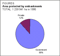 Figure 6. Area protected by embankments. (Source: FAO)
 In 1995, 193,363 ha were reported as equipped with surface drainage networks. Drainage works are also considered a form of flood protection.
Salinization due to irrigation is mainly found in the central dry zone, near Meiktila in Mandalay Division, where groundwater is used for irrigation purposes.
After the decision of the Government to move towards a market-oriented economy, and the consequent freedom given to farmers to cultivate crops of their choice, agricultural cropping patterns have changed dramatically. Jute used to be the second most widely cultivated crop (after rice), but it has now been replaced by cash crops such as beans, pulses, sunflowers, chilies, and vegetables.
Farmers have to pay a tax of 25 kyatts/ha/year for irrigated areas (which is equivalent to US$4.1/ha/year at the official rate and US$0.2/ha/year at the open market rate), and 12 kyatts/ha/year for flood protected areas. Once collected, this revenue is channeled to the Revenue Department. The amount of the tax, decided in 1982, does not take into consideration the nature of the crop, cropping intensity or irrigation technique. It is not clear whether this tax applies to both public and private schemes.
Average irrigation development costs vary from 12,300 to 49,100 kyatts/ha (US$2,000-8,000 or 100-400/ha). Drainage and embankment development cost around 7,400 kyatts/ha (US$1,200 or 60/ha).
The Irrigation Department is responsible for the O&M of the government schemes, and the annual budget for both irrigated and flood protected areas is 200 million kyatts (US$33 million or 1.65 million).
Institutional Environment
The Ministry of Agriculture is the main ministry involved in water resources through its various departments:
- the Water Resources Utilization Department, which is responsible for groundwater use (for both irrigation and rural water supply), irrigation by pumping in rivers, and the development of sprinkler and micro-irrigation;
- the Irrigation Department, which is responsible for O&M of irrigation works, construction of new projects, and investigation, design, and implementation of proposed projects, as long as surface water is used;
- the Settlement and Land Records Department, which is responsible for collecting agricultural statistics and land administration;
- the Agricultural Planning Department, which is in charge of planning, monitoring, and evaluation of all agricultural projects, including irrigation and drainage projects.
The Meteorology and Hydrology Department of the Ministry of Communication, Posts and Telegraphs is in charge of collecting hydrological and meteorological data, while the Irrigation Department has also its own hydrological network. Hydropower generation is supervised by the Myanmar Electric Power Enterprise, within the Ministry of Energy.
Since the promulgation of the Land Nationalization Act (1953), all land officially belongs to the State. However, farm households benefit from a customary usufruct right to the land. There is no water law in Myanmar.
Trends in Water Resources Management
The Government has set a target of 100 percent for water supply coverage in 2000, but a more realistic objective considering the funds allocated for this program would be near 70 percent.
Within the framework of its irrigation policy, the Ministry of Agriculture has decided to undertake:
- the construction of new reservoirs and dams;
- the rehabilitation of existing reservoirs and networks of both government and private sectors, in order to upgrade the storage capacity and allow for an efficient delivery of irrigation water;
- the development of flood protection by embankment, and irrigation expansion after flood recession;
- the development of pump irrigation;
- the development of an efficient use of groundwater for irrigation.
The official target for irrigation development is to irrigate 25 percent of cultivated areas before 2000, which is realistic regarding the ongoing and planned projects. Concerning the flood protected areas, no target has been fixed by the Government although some 400,000 ha in the delta are in need of reclamation.
All new projects related to dam construction are now multipurpose projects and include flood control, town water supply, hydroelectricity, and irrigation. The priority for multipurpose projects with hydropower is an indicator of the expanding demand for energy.
Further Reading
- Central Statistical Organization. 1994. Statistical yearbook 1993. Yangon.
- ESCAP. 1995. Assessment of water resources and water demand by user sectors in Myanmar, p. 40. United Nations.
- FAO. 1995. Agriculture development and environmental rehabilitation project in the dry zone. Project MYA/93/004. Rome.
- Irrigation Department, Ministry of Agriculture. 1995. Information and data on water resources development and flood control. Yangon.
- Ministry of Agriculture. 1994. Report on Myanmar census of agriculture 1993. Yangon.
- Ministry of Agriculture. 1995. Information on Myanmar agriculture. Yangon.
- Tha Tun Oo. 1991. Environmental issues in land and water development in Myanmar (land). Paper presented at the regional expert consultation on environmental issues in land and water development, Bangkok, 10-13 September 1991. FAO/RAPA publication 1992/8. Bangkok.
- U. Aung Myo. 1994. Improved operation and maintenance of lift irrigation systems and management of groundwater resources in Myanmar. Paper presented at the expert consultation of the Asian network on Water lifting devices for irrigation, Bangkok, 27 September - 1 October 1993. FAO/RAPA publication 1994/5. Bangkok.
- U. Ohn Myint. 1991. Environmental issues in land and water development in Myanmar (water). Paper presented at the regional expert consultation on environmental issues in land and water development, Bangkok, 10-13 September 1991. FAO/RAPA publication 1992/8. Bangkok.
- U. Zaw Win. 1993. Myanmar water resources. Irrigation Department, Ministry of Agriculture Yangon.
- UNDP, World Bank, General Administration Department - Urban Water Supply Division. 1993. Water supply and sanitation sector review in Myanmar. Final report prepared by Cowater International Inc., Thant Syn Co. Ltd. Project MYA/86/012. Ottawa.
- World Bank. 1992. Energy sector investment and policy review studies. Report 10394 BA. Washington, D.C.
| Disclaimer: This article is taken wholly from, or contains information that was originally published by, the Food and Agriculture Organization. Topic editors and authors for the Encyclopedia of Earth may have edited its content or added new information. The use of information from the Food and Agriculture Organization should not be construed as support for or endorsement by that organization for any new information added by EoE personnel, or for any editing of the original content. |