Sundarbans National Park, India
Sundarbans National Park (By V Malik from New Delhi & Pune, India (Into the forest, darkly) (http://creativecommons.org/licenses/by-sa/2.0), via Wikimedia Commons)
Contents
- 1 Geographical Location
- 2 Date and History of Establishment
- 3 Area
- 4 Land Tenure
- 5 Altitude
- 6 Physical Features
- 7 Climate
- 8 Vegetation
- 9 Fauna
- 10 Cultural Heritage
- 11 Local Human Population
- 12 Visitors and Visitor Facilities
- 13 Scientific Research and Facilities
- 14 Conservation Value
- 15 Conservation Management
- 16 IUCN Management Category
- 17 Further Reading
Geographical Location
Sundarbans National Park (21°31'-21°53'N, 88°37'-89°09'E) is a World Heritage Site that lies southeast of Calcutta in the 24-Paraganas District of West Bengal and forms part of the Gangetic Delta, which borders on the Bay of Bengal. Consists of Matla, Goashaba, Chhotahardi, Mayadwip, Chamta, Gona and Baghmara forest blocks, which are bounded by the Matla/Bidya and Haribhanga/Raimangal rivers to the east and west, respectively. The northern boundary is buffered by Netidhopani and Chandkhali forest blocks.
Date and History of Establishment
Established as a national park on 4 May 1984 (Notification No. 2867-For). Previously created a wildlife sanctuary in 1977, having been designated as the core area of Sundarbans Tiger Reserve in December 1973. All forest in 24-Paraganas District was first notified as protected forest on 7 December 1878. Much of this was subsequently leased out by the government for purposes of cultivation, but the boundaries of the remaining protected forests were fixed under Notification No. 4457-For, dated 9 April 1926. Protected forests remaining in the Basirhat Division of the district were declared reserved forests on 9 August 1928 (Notification No. 15340) and those remaining in Namkhana Division on 29 May 1943 (Notification No. 7737-For). Inscribed on the World Heritage List in 1985.
Area
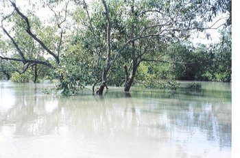 Sundarbans at high tide. (Source: Government of West Bengal: Department of Environment)
 133,010 hectares (ha). Constitutes the core area of Sundarbans Tiger Reserve (258,500 ha). Sajnakhali Wildlife Sanctuary (36,234 ha) lies within the buffer zone, to the north of Netidhopani and Chandkhali forest blocks. Halliday Island (583 ha) and Lothian Island (3,885 ha) wildlife sanctuaries are in the west of the Sundarbans but are not part of the tiger reserve. The wildlife sanctuaries of Sundarbans East (5,439 ha), Sundarbans West (9,069 ha) and Sundarbans South (17,878 ha) lie to the east in Bangladesh but are not contiguous either with the tiger reserve or each other.
Land Tenure
Government.
Altitude
Ranges from sea level to 10 meters (m) at the most.
Physical Features
The Sundarbans, covering some 10,000 square kilometers (km2) of mangrove forest and water (of which some 40% is in India and the rest in Bangladesh), is part of the world's largest delta (80,000 km2) formed from sediments deposited by three great rivers, the Ganges, Brahmaputra and Meghna, which converge on the Bengal Basin. The whole Sundarbans area is intersected by an intricate network of interconnecting waterways, of which the larger channels are often a mile or more in width and run in a north-south direction. These waterways, apart from the Baleswar River on the eastern edge of the Bangladesh Sundarbans, now carry little freshwater as they are mostly cut off from the Ganges, the outflow of which has shifted from the Hooghly-Bhagirathi channels progressively eastwards since the seventeenth century. This is due to subsidence of the Bengal Basin and a gradual eastward tilting of the overlying crust. In the Indian Sundarbans, the western portion receives some freshwater through the Bhagirathi-Hooghly river system but that portion designated as the tiger reserve is essentially land-locked, its rivers having become almost completely cut off from the main freshwater sources over the last 600 years. Thus, waterways in the tiger reserve are maintained largely by the diurnal tidal flow, the average rise and fall being about 2.15 m on the coast and up to 5.68 m on Sagar Island. Tidal waves are a regular phenomenon and may be up to 75 m high. The land is constantly being changed, molded and shaped by the action of the tides, with erosion processes more prominent along estuaries and deposition processes along the banks of inner estuarine waterways influenced by the accelerated discharge of silt from seawater. About half of the Sundarbans is under water and the rest of the landscape is characterized by low-lying alluvial islands and mudbanks, with sandy beaches and dunes along the coast. As with the rest of the Bengal Plain, alluvial deposits are geologically very recent and deep, sediment of just the last few million years being as much as 1,000 m thick. The subsoil consists of alternate layers of clay and sand, gradually changing into shales and sandstone. The soil is clayey loam down to a depth of 1.1-1.4 m and thereafter stiff black clay. It is alkaline due to an excess of sodium chloride. An estimation of land loss and accretion has been made using remote sensing techniques.
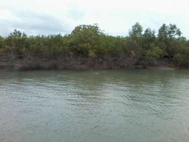 Vegetation along the estuaries (Source: Saikat Basu, own work) Vegetation along the estuaries (Source: Saikat Basu, own work)
|
 Mangal vegetation along the mudflats. (Source: Sakat Basu, own work) Mangal vegetation along the mudflats. (Source: Sakat Basu, own work)
|
Climate
Rainfall is heavy and humidity high (80% on average) due to the proximity of the Bay of Bengal. The monsoon usually lasts from mid-June until mid-September, after which fair weather prevails until mid-March. The mean annual rainfall recorded at the observatory on the nearby Island of Sagar was 2002 millimeters (mm) in 1937-1946, that for Jhingakhali Station in the northern part of the reserved forests was 1,920 mm in 1970-1972. Mean annual maximum and minimum temperatures recorded at the latter was 34 degrees Celsius (°C) and 20°C, respectively. Prevailing wind is from the north and northeast from October to mid-March, although January and February are calm. Violent south-westerlies prevail from mid-March to September. Storms (Tropical weather and hurricanes) are common in May and October-November, sometimes developing into cyclones which are usually accompanied by tidal waves and cause much loss of life and damage to property and the forests. Meteorological data for 1955-1960 are presented by Mukherjee (1975). There are meteorological stations at Haldi, Jhingakhali and Sajnakhali.
Vegetation
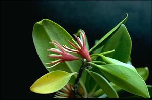 The kankra Bruguiera gymnorhiza is one of the characteristic plants of the tiger reserve. (Source: Australian National Botanic Gardens)
 The entire mangrove forest extends over an area of 4,262 km2, of which 2,320 km2 is forest and the rest is water, and is called Sundarban owing to the dominance of the tree species Heritiera fomes, locally known as 'sundari' because of its elegance. This marsh vegetation consists of elements of the Malayan Peninsular and Polynesian regions, together with some Indo-Chinese, Ethiopian and a few of the New World. It is not found elsewhere except in a small part of the Mahanadi and Godaveri deltas to the southwest and the Bay Islands. Prain (1903) lists 334 species found in the Sundarbans. Champion (1936) classified the Sundarbans as moist tropical seral forest, comprising beach forest and tidal forests. The latter are subdivided into four types, of which only low mangrove forest and salt-water Heritiera forests occur within Indian territory. Beach forest occurs on coastal islands comprising low sand-dunes which, together with lime formed from disintegrating shells and salt, give rise to a pronounced xerophytic habitat despite the high rainfall. Sand-dunes are partially covered with spear-grass, behind which are creepers and shrubs or trees, such as jhao Tamarix troupii, palita Erythrina variegata and kulsi Aegiceras corniculatus. Salt-water Heritiera forest (6-11 m high), a low salinity vegetation type, occurs between the Raimangal and Matla rivers, where freshwater flows from the Ichhamati River into the Raimangal River. Characteristic species include garjan Rhizophora sp., kankra Bruguiera gymnorhiza, goran Ceriops sp., and baen Avicennia officinalis. Heritiera fomes is scattered over areas of higher elevation, along with keora Sonneratia apetala, gengwa Excoecaria agallocha, dhundul Carapa obovata and the date palm or hental Phoenix paludosa. The golpata palm Nipa fruticans is relatively uncommon but occurs on wet mud-banks along the creeks. Low mangrove forest (3-6 m high) occurs between Matla and Muriganga, to the west of the national park and tiger reserve, this area being devoid of freshwater because its rivers are cut off from the ramifications of the Hooghly in the north. Soft mud, which is submerged by the tides, supports a dense forest, very similar in composition to salt-water Heritiera forest except that sundari and golpata are virtually absent. Goran and baen are the commonest trees, occupying extensive areas but only growing up to 2 m. Clusters of hental are very common. Certain forest tracts on low-lying islands were cleared some two hundred years ago and gradually claimed for cultivation. Various trees and other plants were introduced, including some exotics. In a more recent examination of the composition and structure of the mangrove vegetation, 69 plant species are identified. This report also includes inventories of algae, phytoplankton and fungi.
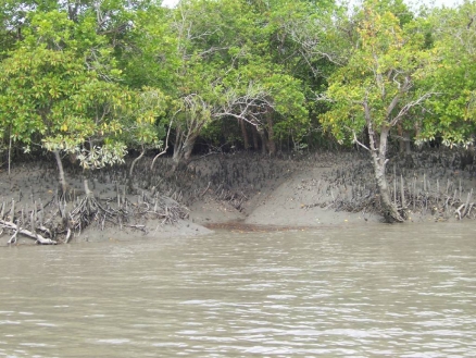
 Pneumatophores or breathing roots (Source: Saikat Basu, own work) Pneumatophores or breathing roots (Source: Saikat Basu, own work)
|
 Mangrove vegetation along the tidal creek (Source: Saikat Basu) Mangrove vegetation along the tidal creek (Source: Saikat Basu)
|
Fauna
The Sundarbans is the only remaining habitat in the lower Bengal Basin for a great variety of faunal species. Some of this variety, however, has already been lost owing to the reclamation of the broad transitional belt of habitat for agriculture, combined with the higher salinity resulting partly from the large-scale irrigation schemes in the upper reaches of the Ganges. Species include the Javan rhinoceros Rhinoceros sondaicus (E) and water buffalo Bubalus bubalis (V), last recorded in 1870 and 1885, respectively, swamp deer Cervus duvauceli (E), which existed in good numbers until early this century, and Indian muntjac Muntiacus muntjak, last reported on Halliday Island in the late 1970s. Similarly, gharial Gavialis gangeticus (E) and narrow-headed softshell turtle Chitra indica became locally extinct within the last century. Mukherjee (1975) provides an extensive account of the vertebrate and invertebrate fauna. More recently, inventories have been compiled.
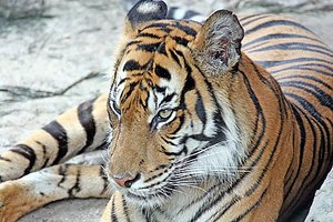 Panthera tigris is the largest tiger population in India. (Source: Marietta College)
 The tiger Panthera tigris (E) population, estimated at 251 in 1993, is the largest in India. High population density, relative to the availability of prey, and the relatively high frequency of encounters with local people (within the tiger reserve) is probably largely responsible for the notorious man-eating habits of the Sundarbans tiger. The fishing cat Felis viverrinus (K) abounds. The only ungulates are wild boar Sus scrofa, main prey species of the tiger, and spotted deer Cervus axis, which is plentiful and often seen in association with rhesus macaque Macaca mulatta. Aquatic mammals that frequent the tidal waters include the Ganges dolphin Platanista gangetica, Indo-Pacific hump-backed dolphin Sousa chinensis (K), Irrawaddy dolphin Orcaella brevirostris (K) and finless porpoise Neophocaena phocaenoides (K).
The Sajnakhali area contains a wealth of water birds, noteworthy residents including Asian openbill stork Anastomus oscitans, black-necked stork Ephippiorhynchus asiaticus, greater adjutant Leptoptilos dubius (E), white ibis Threskiornis melanocephalus, swamp francolin Francolinus gularis, white-collared kingfisher Halcyon chloris, black-capped kingfisher H. pileata and brown-winged kingfisher Pelargopsis amauroptera. This area is important for waders, including the Asian dowitcher Limnodromus semipalmatus (R), a rare winter migrant. Interesting marsh birds found in the reclaimed areas include egrets Egretta alba, E. garzetta and E. intermedia, purple heron Ardea purpurea (a rare vagrant from Africa) and green-backed heron Butorides striatus, while birds of prey include osprey Pandion haliaetus, Pallas's sea-eagle Haliaeetus leucoryphus (R), white-bellied sea-eagle H. leucogaster, grey-headed fishing eagle Ichthyophaga ichthyaetus, peregrine falcon Falco peregrinus, Oriential hobby F. severus, northern eagle owl Bubo bubo and brown fish owl Ketupa zeylonensis. A variety of terns (Sterna and other genera) and kingfishers are seen on the large rivers and in flooded areas (Mukherjee, 1975). Other details of the avifauna are given by Law (1954, 1956).
The Sundarbans provide important habitat for a variety of reptiles including river terrapin Batagur baska (E), olive ridley Lepidochelys olivacea (E), estuarine crocodile Crocodylus porosus (E), monitor lizard Varanus flavescens, water monitor V. salvator and Indian python Python molurus (V). The only species of turtle known to nest in the Sundarbans is the olive ridley but hawksbill Eretmochelys imbricata has been caught in fishermen's nets. The creeks are spawning grounds for some 90 species of fish, 48 species of crabs and a large variety of mollusks.
Cultural Heritage
Baghmara Forest Block contains the ruins of a city built by the Chaand Sandagar merchant community approximately 200-300 AD. Much later, during the Moghul Empire, Raja Basand Rai and his nephew took refuge in the Sundarbans from the advancing armies of Emperor Akbar. The buildings which they erected subsequently fell to Portuguese pirates, salt smugglers and dacoits in the 17th century. The ruins are evident at Netidhopani and elsewhere. The Sundarbans feature prominently in Bengali literature, for example Bankim Chandra Chatterjee's novel "Kapal Kundla". Banbibi, incarnation of the Goddess Durga, is the reigning deity in the area. Her blessings are sought for protection from the tiger. Reclamation of the Sundarbans commenced in 1770 and is described by Bandyopadhyay (1985).
Local Human Population
There is no resident human population within the tiger reserve. In 1981, the population in the fringe area was 2.5 million, but by 1991 had increased to 3 million. Some 35,330 people work in the forest annually, of which 4,580 collect timber and firewood, 24,900 are fisherman, 1,350 collect honey and 4,500 are involved in other activities. Various aspects of honey production are discussed by Chakrabarti (1987c). On average some 4,000 fishermen are active each day, and the mean annual catch is 2,500 tonnes.
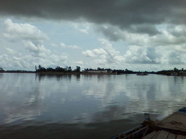 Human settlements (Source: Saikat Basu, own work) Human settlements (Source: Saikat Basu, own work)
|
 Fishing activities along the tidal shores and channels (Saikat Basu, own work) Fishing activities along the tidal shores and channels (Saikat Basu, own work)
|
Visitors and Visitor Facilities
Visitors are not allowed within the national park. Elsewhere in the tiger reserve, the Sundar Cheetal Tourist Lodge at Sajnakhali provides the only accommodation (60 beds). Here, the Mangrove Information Centre has recently been completed. Nearby is a heronry which can be visited by boat. There are watchtowers at Sajnakhali, Sudhanyakhali, Netidhopani, Haldi and a number of other places. Access to the tiger reserve is by permit and via Port Canning, by boat and/or bus to Basanti, Gosaba and Sajnakhali. Launches can be hired from the Tourist Bureau or Sundarbans Launch Association in Calcutta.
Scientific Research and Facilities
Early contributions to the flora and avifauna include Prain (1903) and Law (1954, 1956), respectively. Mukherjee (1975) gives a fairly comprehensive account of both flora and fauna, based largely on his visits to the Sundarbans in 1955-1960. Mukherjee and Gupta (1965) examined the habits of the rhesus macaque and Mukherjee (1969, 1971, 1972) studied the feeding behavior of the water birds. Factors associated with man-eating by tigers are analyzed by Chakrabarti (1986a). The tiger population is censused every two years. Chakrabarti (1986b, 1987b) has shown that species diversity is greater below the tidal level than above and that in general floral diversity is lower than in the forests of North and South Bengal. A long-term monitoring program has been carried out since 1980 by the Marine Science Department of Calcutta University (1987). A preliminary floral survey has been conducted jointly by Sundarbans Tiger Reserve and Botanical Survey of India. Likewise, the fauna has been surveyed by the Sundarbans Tiger Reserve and Zoological Survey of India. The latter has set up a research station at Canning Town. There is also the Central Inland Fisheries Research Station at Kakdwip, Sagar Marine Biological Institute on the westernmost island and Central Soil Saline Research Institute at Canning Town. An outlines of the ecology, botany and forestry is given by Blasco (1977).
Conservation Value
The Sundarbans contains the world's largest region of mangrove forests, with 36 true mangrove, 28 associated and seven obligatory mangrove species representing 29 families and 49 genera. Apart from being the only mangrove forest in the world inhabited by the tiger, the Sundarbans contains a rich and unique biota, with a notable number of threatened reptiles.
Conservation Management
The Sundarbans buffer inland areas from the ravages of cyclones from the Bay of Bengal and provides the main nursery for shrimps along the whole coast of eastern India, as well as its creeks being the spawning grounds for a wealth of fish and crustaceans. That part of the Sundarbans lying in Indian territory is managed under the aegis of Project Tiger. In the original management plan, the core area, now a national park, is designated a wilderness zone (133,010 ha) within which 12,440 ha is earmarked as a Primitive Area strictly reserved for preservation. The remaining area comprises a buffer zone. No forestry operations or any other type of interference is allowed in the core area. Elsewhere in the tiger reserve, forests are subject to 'selection-cum-improvement' felling. Exploitation of the hental date palm and golpata palm, and seasonal collection of honey are allowed on a permit basis. Local people may also fish in the tidal waters but require a permit for firewood used during such trips. A new management plan has been prepared and submitted for approval. In 1982, 24 captive-bred estuarine crocodiles were re-introduced to the area. There has been a marked improvement in the biota, which has ultimately been reflected in a steady rise in the tiger population. Based on censuses of tracks, data suggest that the tiger population has increased at an annual rate of 7% from 181 in 1976 to 264 in 1983. Freshwater ponds have been constructed in several localities for the benefit of the wildlife. Olive ridleys are reared in captivity at Sajnakhali and for subsequent release into the national park. Proposals to establish a Sundarbans Biosphere Reserve are under consideration. The proposed area of 9,630 km2 south of the "Dampier-Hodges Line" comprises the tiger reserve and national park, three wildlife sanctuaries, and reclaimed intertidal areas having only a single crop per year.
Participatory management is practiced with local villagers, and eco-development projects have provided them with freshwater sources, medical clinics, and employment on tourist boats and as guides.
Management Constraints
Siltation appears to be an increasing problem. For example, it is thought by local fishermen that within the next few years the Matla River will no longer be navigable up to Canning Town. There are plans to construct a fertilizer plant at Mathurapur, just 5 km from the Satpukur sluice gate at the edge of the Sundarbans. Harmful effluents (sulfur dioxide, sulphates and fluorine) would enter the waterways of the Sundarbans. Oil spills are a potential threat which cause immense damage, especially to aquatic fauna and seabirds and probably also to the forest itself into which oil could be carried by high tides. Between 1975 to 1982, an average of 45 people were annually killed by tigers. This casualty rate has fallen since the introduction of various measures, including deterrents in the form of electrified human dummies and face masks worn on the back of the head. Between 1994 and 1995, the number of victims fell to less than 12, and this has been reduced to 2-4 per year, and villagers now tend to drive tigers back into the forest rather than kill them. Reclamation in the Sundarbans ecosystem has lead to problems of salinization and soil acidification although the degree to which this affects the national park is not known. The other main management constraint is poaching.
Staff
There are 202 personnel headed by the Field Director and including 68 enforcement staff, one research officer and one assistant research officer (1986/1987).
Budget
Rs 70 lakh, of which Rs 18.5 lakh is from the State Government and the rest from Central Government (1994/1995).
IUCN Management Category
- Ia (Strict Nature Reserve)
- Natural World Heritage Site - Criteria ii, iv
Further Reading
- Anon. (1989). Maneaters and masks. Newsletter of the IUCN SSC Cat Specialist Group. CatNews 11:12.
- Bhaskar, S. (1984). Sea turtles in Eastern India. WWF Monthly Report August 1985: 185-189.
- Blasco, F. (1977). Outlines of ecology, botany and forestry of the Mangals of the Indian Subcontinent. In: Chapman, V.J. (Ed.) Wet coastal ecosystems. Ecosystems of the World No. 1. Elsevier Scientific Publishing Company, Amsterdam. Pp. 241-257.
- Blower, J.H. (1985). Sunderbans Forest Inventory Project, Bangladesh. Wildlife conservation in the Sundarbans. Project Report 151. ODA Land Resources Development Centre, Surbiton, U.K. 39 pp.
- Calcutta University (1987). A long term multidisciplinary research approach and report on mangrove ecosystem of Sundarbans. Department of Marine Science, University of Calcutta. 92pp. (Includes an extensive bibliography.)
- Chakrabarti, K. (1986a). Tiger (Panthera tigris tigris) in the mangrove forests of Sundarbans - an ecological study. Tigerpaper 13(2): 8-11.
- Chakrabarti, K. (1986b). Generic and species diversity of animal vegetation dynamics of Sundarbans and Mangrove South Bengal laterite tracts of West Bengal and North Bengal Forest - an ecological study. The Indian Forester 112: 407-416.
- Chakrabarti, K. (1986c). Fish and fish resources in the mangrove swamps of Sundarbans, West Bengal - an indepth study. The Indian Forester 112: 538-542.
- Chakrabarti, K. (1987a). Sundarbans mangroves - biomass productivity and resources utilization: an indepth study. The Indian Forester 113: 622-628.
- Chakrabarti, K. (1987b). Sundarbans mangroves of India - a study of conservation status. The Indian Forester 113: 352-358.
- Chakrabarti, K. (1987c). Sundarbans honey and the mangrove swamp. Journal of the Bombay Natural History Society, 84: 133-137.
- Chakrabarti, K. (1993). Biodiversity of the mangrove ecosystem of Sundarbans. Indian Forester 119(11): 891-898.
- Champion, H.G. (1936). A preliminary survey of the forest types of India and Burma. Indian Forest Reocrd (New Series) 1: 1-286.
- Chowdhury, M.K. and Sanyal, P. (1985). Use of electroconvulsive shocks to control tiger predation on human beings in Sundarbans Tiger Reserve. Tigerpaper 12(2): 1-5.
- Gupta, R.D. (1987). Save the Sundarbans. Sunday, Calcutta. 27 September- 3 October 1987: 40.
- Hendrichs, H. (1975). The status of the tiger Panthera tigris (Linne, 1758) in the Sundarbans mangrove forest (Bay of Bengal). Saugetierkundliche Mitteilungen 23: 161-199.
- Jain, S.K. and Sastry, A.R.K. (1983). Botany of some tiger habitats in India. Botanical Survey of India, Howrah. Pp. 40-44.
- Lahiri, R.K. (1973). Management plan of tiger reserve in Sundarbans, West Bengal, India. Department of Forests, West Bengal. 101 pp.
- Law, S.C. (1954, 1956). A contribution to the ornithology of the Sundarbans. Journal of the Bombay Natural History Society 27: 59-65, 28: 149-152.
- Mahapata, A.K. (1978). A brief survey of some unrecorded less known and threatened plant species of Sundarban of West Bengal India. Bulletin of the Botanical Society of Bengal, 32 (1-2): 54-58. (Not seen)
- Milne, R.C. (1997) Mission Report: South Asia meeting to review status conservation of world natural heritage and design and cooperative plan of action. 16-19 January 1997, New Delhi, India. Prepared for the World Heritage Centre, UNESCO. Unpublished Report, 7pp.
- Mukherjee, A.K. (1959). Pakhirala, Sajnakhali - an introduction to a bird sanctuary in the Sundarbans. Journal of the Bengal Natural History Society 30: 161-165.
- Mukherjee, A.K. (1969, 1971, 1972). Food habits of water-birds of the Sundarbans, 24-Parganas District, West Bengal. Journal of the Bombay Natural History Society 66: 345-360., 68: 37-64, 68: 691-716.
- Mukherjee, A.K. (1975). The Sundarban of India and its biota. Journal of the Bombay Natural History Society 72: 1-20.
- Mukherjee, A.K. and Gupta, S. (1965). Habits of the rhesus macaque, Macaca mulatta (Zimmerman) in the Sundarbans, 24-Parganas, West Bengal. Journal of the Bombay Natural History Society 62: 145-146.
- Murthy Naidu, K.S. and Madhavan Unni, N.V. (1986). On sequential image analysis for estimation of land loss/accretion in Sundarbans. In: Kamat, D.S. and Panwar, H.S. (Eds). Wildlife habitat evaluation using remote sensing techniques. Proceedings of the seminar-cum-workshop organized by the Indian Institute of Remote Sensing and Wildlife Institute of India, October 22-23. Pp. 248-257.
- Naskar, K., Guha Bakshi, D.N. (1983). A brief review on some less familiar plants of the Sundarbans India. Journal of Economic and Taxonomic Botany 4(3): 699-712.
- Prain, D. (1903). Flora of the Sundarbans. Record of the Botanical Survey of India 2: 231-390.
- Rishi, V. (1988). Man, Mask and Maneater. Tiger Paper 15(3): 9-14.
- Sanyal, P. (n.d.). Sundarbans Biosphere Reserve. Project Document - 1. Office of the Chief Conservator of Forests, Calcutta. 32 pp. (Includes an extensive bibliography.)
- Sanyal, P. (1983). Mangrove tiger land, the Sundarbans of India. Tigerpaper 10(3): 1-4.
- Sanyal, P. and Bal, A.R. (1986). Some observations on abnormal adaptations of mangrove in Indian Sundarbans. Indian Soc. Coastal agric. Res. 4: 9-15.
- Sanyal, P., Banerjee, L.K. and Choudhury (1984). Dancing mangals of Indian Sundarbans. J. Indian Soc. Coastal agric. Res. 2(1): 10-16.
- Seidensticker, J. and Hai, A. (1983). The Sundarbans Wildlife Management Plan: conservation in the Bangladesh coastal zone. IUCN, Gland, Switzerland. 120 pp. ASIN: B0007B0200
- WWF / IUCN Project 1010. Operation Tiger, India - Sundarbans Forest Reserve, West Bengal.
- WWF/IUCN Project 3045. Sea turtle survey in the Indian Sundarbans, Gahirmatha and Wheeler Islands, Orissa.
| Disclaimer: This article is taken wholly from, or contains information that was originally published by, the United Nations Environment Programme-World Conservation Monitoring Centre (UNEP-WCMC). Topic editors and authors for the Encyclopedia of Earth may have edited its content or added new information. The use of information from the United Nations Environment Programme-World Conservation Monitoring Centre (UNEP-WCMC) should not be construed as support for or endorsement by that organization for any new information added by EoE personnel, or for any editing of the original content. |