Remote sensing of sea ice
Contents
Remote Sensing
Remote sensing, in simplest terms, means viewing something from a distance rather than by direct contact. A handheld camera is an example of a remote sensing instrument. In terms of earth science, remote sensing refers to the ability of satellites to detect electromagnetic radiation from features on the Earth’s surface or in the atmosphere. Solar energy that reaches the Earth is composed of many kinds of radiation, including light that is visible to people, thermal infrared, microwave, radar, and X-rays. Every substance with a temperature greater than absolute zero (-273 degrees Celsius, or -459 degrees Fahrenheit) emits some form of electromagnetic radiation. Some satellite sensors detect visible light reflected from the Earth’s surface or atmosphere, and others detect radiation emitted from the Earth.
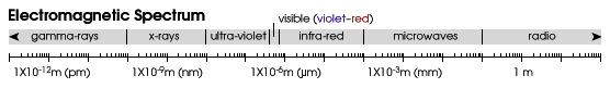
Satellites can easily measure sea ice in the visible, infrared, and microwave regions of the electromagnetic spectrum. However, there are advantages and disadvantages to each type of radiation. None of the spectral regions allow scientists to optimally view sea ice in all conditions. The following sections describe each region in more detail.
Visible
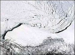 Satellite view of sea ice breaking up in the Beaufort Sea off Alaska, 15 April 2004. The top half of the image with several dark lines is the sea ice, and the solid white object is the coast of Alaska with a fringe of fast ice. This visible image was captured from the Moderate Resolution Imaging Spectroradiometer (MODIS) sensor on NASA's Terra satellite. (Image courtesy of MODIS Rapid Response Project at NASA/GSFC; Source: NSIDC)
 The light that our eyes detects is visible solar radiation, reflected off objects around us. “Whiter” objects (those with a high albedo) reflect more radiation than “darker” objects. Sea ice has a higher albedo than the surrounding ocean, which makes it easy to detect from visible remote sensing instruments. Some limitations in using reflected visible light to observe sea ice from space include the following:
- Since these sensors measure reflected radiation from the sun, visible data can only be collected during the daytime. The inability to measure at night is a problem for measuring sea ice, which exists in polar regions where darkness prevails.
- Because clouds also reflect visible radiation, a cloudy sky prevents satellites from viewing visible light reflected from sea ice. Unfortunately, ice-covered polar regions tend to be cloudy, with clouds obscuring sea ice 70 to 90 percent of the time.
The following satellites and sensors are a selection of those that observe visible radiation; these are often used to identify and map sea ice.
- The Defense Meteorological Satellite Program (DMSP) Operational Linescan System (OLS)
- The National Oceanic and Atmospheric Administration (NOAA) Advanced Very High Resolution Radiometer (AVHRR)
- The National Aeronautics and Space Administration (NASA) Moderate Resolution Imaging Spectroradiometer (MODIS)
Infrared
Satellite sensors that measure infrared radiation infer the amount of heat emitted from an object at the Earth’s surface. Objects with an average Earth temperature (roughly -50 to 50 degrees Celsius, or -58 to 122 degrees Fahrenheit) emit most of their energy in the infrared region.
Infrared sensors can easily detect sea ice because its temperature is generally much colder than the surrounding ocean. A typical winter sea ice temperature is -20 to -40 degrees Celsius (-4 to -40 degrees Fahrenheit), while the surrounding ocean temperature is above freezing. Limitations in measuring infrared radiation from space include the following:
- Because clouds also emit and reflect infrared radiation, clouds prevent satellites from detecting infrared radiation from sea ice
- Sea ice melts during the summer, and the surface temperature increases to the freezing point. Melting sea ice is difficult to distinguish from surrounding ocean that is also near the freezing point.
The following satellites and sensors observe infrared radiation.
- The Defense Meteorological Satellite Program (DMSP) Operational Linescan System (OLS)
- The National Oceanic and Atmospheric Administration (NOAA) Advanced Very High Resolution Radiometer (AVHRR)
- The National Aeronautics and Space Administration (NASA) Moderate Resolution Imaging Spectroradiometer (MODIS)
Passive Microwave
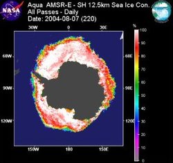 Antarctic sea ice concentration, ranging from 0 percent (purple) to 100 percent (white) on 07 August 2004. Antarctica is shown in grey, and the unfrozen ocean is shown in dark blue. Sea ice concentration was calculated from data measured by the Advanced Microwave Scanning Radiometer–Earth Observing System (AMSR-E) sensor aboard NASA's Aqua satellite. (Image courtesy of Matt Smith, Information Technology and Systems Center, University of Alabama at Huntsville; Source: NSIDC)
 Objects at the Earth’s surface emit not only infrared radiation; they also emit microwaves at relatively low energy levels. When a sensor detects microwave radiation naturally emitted by the Earth, that radiation is called passive microwave. Clouds do not emit much microwave radiation, compared to sea ice. Thus, microwaves can penetrate clouds and be used to detect sea ice during the day and night, regardless of cloud cover.
Microwave emission is not as strongly tied to the temperature of an object, compared to infrared. Instead, the object’s physical properties, such as atomic composition and crystalline structure, determine the amount of microwave radiation it emits. The crystalline structure of ice typically emits more microwave energy than the liquid water in the ocean. Thus, sensors that detect passive microwave radiation can easily distinguish sea ice from ocean.
A major drawback to measuring passive microwave radiation is that the energy level is quite low. As a result, the radiation must be collected over a larger region. Details of the sea ice, such as leads, are not easily detected.
Because of their ability to detect sea ice through clouds during the day and night, passive microwave sensors provide nearly complete images of all sea ice-covered regions every day. These sensors have provided the most complete, long-term observations of sea ice, allowing scientists to detect notable changes in Arctic sea ice.
Sea ice observations from passive microwave sensors began in 1972 with the Electrically Scanning Microwave Radiometer (ESMR) aboard NOAA’s Nimbus-5 satellite. In 1978, NASA’s Scanning Multichannel Microwave Radiometer (SMMR) provided detailed, reliable information about sea ice. In 1987, a series of DMSP Special Sensor Microwave/Imager (SSM/I) sensors continued the time series, or long-term record, of sea ice data through present. In 2002, NASA launched the Aqua satellite, which carried the Advanced Microwave Scanning Radiometer–Earth Observing System (AMSR-E) sensor. The system's improved technology complemented the time series of sea ice data. ESMR, SMMR, SSM/I, and AMSR-E sea ice data are available from NSIDC.
Active Microwave
In addition to passively sensing emissions coming from objects on Earth, satellite sensors can also actively emit microwaves toward the Earth’s surface. These microwaves reflect off the surface and return to the sensors. This type of remote sensing is called active microwave, or radar. This same technology is used to track aircraft, ships, and speeding automobiles. As with passive microwave energy, the physical properties of objects at the Earth’s surface determine the amount and characteristics of microwave radiation bounced back to the sensor. Three types of active microwave sensors are used to detect sea ice.
Imaging radar
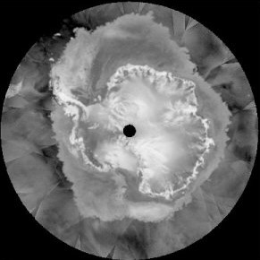 Scatterometer image of Antarctica, 19 July 2003, from the QuikSCAT satellite. This composite image is centered over the South Pole. Antarctica stands out with a white outline. Surrounding Antarctica is a large region of sea ice, shown in medium grey. Sea ice typically reflects more of the radar energy emitted by the sensor than the surrounding ocean, so it appears brighter in a scatterometer image. The black hole over the South Pole is a region that the QuikSCAT satellite does not reach. (Image courtesy of David Long, Brigham Young University Center for Remote Sensing; Source: NSIDC)
 Imaging radar is similar to a photograph taken by a camera, but the image is of radar waves, not visible light. Sea ice typically reflects more of the radar energy emitted by the sensor than the surrounding ocean, which makes it easy to distinguish between the two. But the amount and character of reflected energy are functions of the physical properties of the sea ice, which can be quite complex; thus, it can be difficult to interpret radar images of sea ice. In general, though, thicker multiyear ice is readily distinguishable from younger, thinner ice because radar energy bounces back to the sensor from the bubbles in the ice left when brine drains. This feature makes synthetic aperture radar (SAR) an especially useful tool for measuring the extent of thick vs. thin sea ice.
SAR is a special type of imaging radar that involves advanced technology and complex data processing to obtain detailed images of sea ice. The RADARSAT mission, managed by the Canadian Space Agency, is the primary SAR mission today.
SAR instruments can even detect small leads in sea ice. This fine resolution allows them to analyze sea ice and help route ships through ice-covered regions. SAR imagery is particularly valuable for operational ice centers.
Non-imaging radar
This type of sensor, also called a scatterometer, measures the amount of reflected energy, or backscatter, from the Earth’s surface. It cannot obtain the same detail as a SAR sensor, but it does provide complete, daily data about sea ice day and night, through cloud cover. Images from non-imaging radar have about the same level of detail as passive microwave imagery. The SeaWinds sensor aboard NASA’s Quick Scatterometer (QuikSCAT) satellite provides daily, global views of ocean winds and sea ice
Altimetry
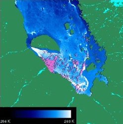
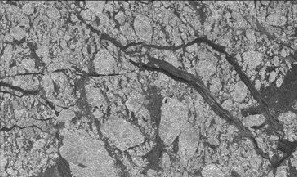 Radar image of sea ice in Beaufort Sea, north of Alaska, captured from RADARSAT. Open leads or leads covered with thin ice appear as dark lines interwoven in the sea ice. Thicker multiyear floes appear brighter. (Image courtesy of NASA JPL, University of Alaska–Fairbanks; Source: NSIDC)
 This sensor sends a pulse of radar energy toward the Earth and measures the time it takes to return to the sensor. The pulse’s round-trip time determines how far the satellite is from the reflecting surface. With a known reference, this information is used to measure the altitude of various features at the Earth’s surface. With enough precision, a radar altimeter can determine the height of the sea ice surface above sea level, which scientists use to calculate the total thickness of the sea ice.
Early satellites with radar altimeters were not in orbits that adequately covered the poles, so they did not collect substantial sea ice data. Fortunately, this is changing. Cryosat, a European Space Agency (ESA) satellite that was to be launched in September 2005, was specifically designed to detect ice-covered regions of the Earth, including sea ice.
Another type of altimeter, called laser altimeter, sends pulses of visible light toward the Earth. The Ice, Cloud, and land Elevation Satellite (ICESat), launched in 2002 by NASA, was designed for studying ice-covered regions. ICESat is already collecting valuable data about sea ice thickness. ICESat data are available from NSIDC.
Further Reading
- Canadian Ice Service homepage
- ESA - Living Planet Programme - CryoSat-2.
- ICESat homepage
- National Ice Center homepage
- RADARSAT-1 Overview
- WINDS: Measuring Ocean Winds from Space
| Disclaimer: This article is taken wholly from, or contains information that was originally published by, the National Snow and Ice Data Center. Topic editors and authors for the Encyclopedia of Earth may have edited its content or added new information. The use of information from the National Snow and Ice Data Center should not be construed as support for or endorsement by that organization for any new information added by EoE personnel, or for any editing of the original content. |