Nahanni National Park Reserve, Canada
| Topics: |
Contents
- 1 IntroductionNahanni National Park Reserve (61°04'-62°00'N, 123°36'-127°30'W) is a World Heritage Site in the mountain (Nahanni National Park Reserve, Canada) wilderness of Canada's Northwest Territories along the South Nahanni River near the Yukon border. It has one of the most spectacular wild river canyons, wilderness waterfalls and limestone landscapes in North America. It contains a unique karst cave system, is home to animals of the boreal forest like wolves, grizzly bears and caribou and on the its alpine levels live dall sheep and mountain goats.
- 2 Geographical location
- 3 Date and history of Establishment
- 4 Area
- 5 Land tenure
- 6 Altitude
- 7 Physical features
- 8 Climate
- 9 Vegetation
- 10 Fauna
- 11 Cultural heritage
- 12 Local human population
- 13 Visitors and visitor facilities
- 14 Scientific research and facilities
- 15 Conservation value
- 16 Conservation management
- 17 IUCN management category
- 18 Further reading
IntroductionNahanni National Park Reserve (61°04'-62°00'N, 123°36'-127°30'W) is a World Heritage Site in the mountain (Nahanni National Park Reserve, Canada) wilderness of Canada's Northwest Territories along the South Nahanni River near the Yukon border. It has one of the most spectacular wild river canyons, wilderness waterfalls and limestone landscapes in North America. It contains a unique karst cave system, is home to animals of the boreal forest like wolves, grizzly bears and caribou and on the its alpine levels live dall sheep and mountain goats.
Geographical location
In the south-west corner of the Northwest Territories, in roadless wilderness 1,400 kilometers (km) north of Edmonton, on the South Nahanni and Flat Rivers. Access is by the Liard Highway, 64 km to the east and via airstrips at Rabbitkettle Lake and Virginia Falls. Nahanni Butte is the nearest village, 20 km from the park's eastern boundary. 61°04'-62°00'N, 123°36'-127°30'W.
Date and history of Establishment
- 1972: Established as a National Park Reserve for its wilderness value; Canadian National Park status will follow settlement of aboriginal claims;
- 1987: The section of the South Nahanni River in the Reserve was designated a Canadian Heritage River by the Canadian Heritage Rivers Board; 1994: Reserve site extended.
Area
Nahanni National Park spans 476,560 hectares (ha).
Land tenure
Government of Canada is responsible for the management of the park.
Altitude
From 180 meters (m) to 2,640 m (Ragged Range).
Physical features
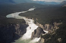 Nahanni River. (Source: Nahanni National Park)
 The Park lies in the northern section of the taiga cordilleran physiographic region; a diverse area of mountain ranges, rolling hills, high plateaus, broad depressions and incised valleys. The southern boundary edges the boreal cordillera and the eastern end reaches the taiga plains. The western end is formed by the Selwyn range of the Mackenzie Mountains and the sawtoothed igneous Ragged Range which both carry glaciers. In a valley below the Ragged Range, a tufa mound 60 m wide called Rabbitkettle, rises 30 m in a succession of intricate terraces around a hot spring. Contrasting sharply with these, in the center and east of the Park, are sections of the deeply dissected sandstone, mudstone, shale and limestone Funeral and Headless Ranges and Tlogotsho and Liard Plateaus, and the Mackenzie plain. Large areas of the center of the Park have remained unglaciated for up to 300,000 years. Near the eastern end, in an area of sands, are 6 m high wind-eroded forms of white sandstone, the Sand Blowouts, and the Yohin lake
Some 270 km of the South Nahanni River, one of North America's finest wild rivers, runs through the Park covering a seventh of the river's 35,000 square kilometer (km2) watershed which drains via the Liard River into the Mackenzie basin. The South Nahanni and its tributary, the Flat River, are older than most of the mountain ranges through which they cut. Within the Reserve the river drops 475 m overall, over Virginia Falls in a spectacular drop 92 m high, then runs for 70 km through a series of four canyons from 460 to 1,200 m deep, and through karst terrain with grottoes, sink holes, labyrinths, closed canyons and an underground river system. The river level is low in winter but, following the spring thaw, there are high flow levels and flash floods from June to September.
Climate
Cold continental with wide monthly variations in temperature and precipitation: maximum and minimum temperatures recorded at Fort Liard are 34°C and -46.7°C respectively. From June to August the mean maximum and minimum temperatures at Tungsten, 35 km west, are 17°C and 6°C; the absolute maximum and minimum for these months are 30°C to 0°C. Average June to August monthly precipitation is between 60 and 90 millimeters (mm), with severe thunderstorms occurring in July. Temperatures decrease and precipitation tends to increase with elevation. Snow may fall at any time of the year.
Vegetation
Over 700 species of vascular plants and 325 species of bryophytes have been identified within the Park, the richest diversity of vegetation of any comparable area in the Northwest Territories. This is due to the presence of highly specialized habitats such as hot and cold mineral springs, waterfall mist zones, wet calcareous substrates and unglaciated terrain. The park contains vegetation types of two major biomes, Nearctic boreal forest and Nearctic alpine tundra with transitional stages between. All stages of boreal forest occur, from recent burns to mature spruce forests, and from wet lowlands to alpine tundra. Densely growing white spruce Picea glauca and poplar Populus sp. dominate valley bottoms. At higher altitudes and on the northern slopes, black spruce Picea mariana is more prominent, and in the west, lodgepole pine Pinus contorta. There is an area of spruce-larch/lichen taiga with several orchid species near Virginia Falls. Alpine tundra characterized by sedges Carex spp., lichens, grasses and shrubs occurs on the higher [[mountain]s] of the Tlogotsho, Headless and Funeral ranges. Wild mint Lamius sp.,golden rod Solidago sp.,yellow monkey-flower Mimulus guttatus and the endemic aster Aster nahanniensis are among the many flowering plants that grow in abundance beside mineral springs near Flat River.
Fauna
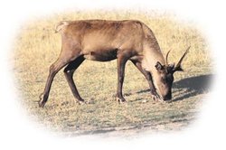 Woodland Caribou, one of the many species of mammals present at the Nahanni National Park Reserve. (Source: Sustainable Resource Development)
 The wildlife is diverse for the relatively high latitude of the Park, and adapted by seasonal movement or hibernation to its severe winters. 42 species of mammals are present including beaver Castor Canadensis, grey wolf Canis lupus, grizzly bear Ursus arctos, black bear U. americanus, otter Lutra canadensis, wolverine Gulo gulo (VU), lynx Lynx canadensis, woodland caribou Rangifer tarandus caribou, moose Alces alces, white-tailed deer Odocoileus virginianus, mountain goat Oreamnos americanus, Dall sheep Ovis dalli, and a wide range of rodents. A total of 180 species of birds in 29 families have been observed including peregrine falcon Falco peregrinus anatum, golden eagle Aguila chrysaetos and bald eagle Haliaeetus leucocephalus. A small population of trumpeter swan Olor buccinator, a rare species in Canada, nests on Yohin lake. There are no known reptiles and few amphibians. 16 species of fish are known. Arctic grayling Thymallus arcticus signifer, Dolly Varden trout Salvelinus alpinus malma and lake trout Salvelinus namaycush are common in the streams that flow into the Nahanni and Flat Rivers.
Cultural heritage
There are signs that prehistoric man used the area of the Park. The original inhabitants were the Goat or Mountain Indians known as the Kaska who were living there when the Northwest and Hudson Bay fur trading companies established their posts along the Mackenzie River in the 1820's. They have been replaced by the Mountain Dene tribe of the Deh-Cho (Big River) First Nations, a Slavey-speaking people.
Local human population
A road reached Fort Liard from the Alaska Highway only in 1979; by 1981 the population around the Park was approximately 2,000. Some 100 Nahanni Denes following a traditional way of life live at Nahanni Butte at the junction of the South Nahanni and Liard rivers at the southern end of the Park. Fort Liard and Jean Marie are 90% indigenous communities of Denes and Métis (people of mixed blood); Fort Simpson (981 inhabitants) is almost equally split between native and non-native residents; Tungsten (380), a private company mining settlement west of the Park, is ethnically non-native. These settlements rely on a varied range of economic activities: staging for oil and gas exploration, mining, mining industry services and staging, commercial logging and sawmilling, air and road transport and handicraft production.
Visitors and visitor facilities
The visitor season is short, the peak period being during July (36%) and August (53%). Approximately 1,350 people visited the Park in 1993, a number necessitating portable waste and fire facilities to preserve the wilderness unpolluted. Visitor facilities are few, but include three campgrounds at Rabbitkettle Lake, Virginia Falls and Kraus Hotsprings. Park staff at the first two sites provide interpretative services. Whitewater canoing, kayaking, hiking (basically a riverside track) and one-day aerial visits are all popular. Aircraft charter from local towns is the most popular and practical means of access and scheduled air services are available from Fort Simpson, Watson Lake and Fort Nelson to Rabbitkettle Lake and Virginia Falls.
Scientific research and facilities
Ecological land classification, faunal inventories, limnology, geomorphology and palaeozoological studies of Dall sheep have all been completed. Current areas of study include radio-collaring woodland caribou, developing an ecosystem monitoring (Environmental monitoring and assessment) program, and bear habitat study. There are no research facilities.
Conservation value
Nahanni National Park Reserve is an outstanding example of northern wilderness rivers, canyons and alpine tundra. The Park protects an area of national significance representative of the Mackenzie Mountains Natural Region.
Conservation management
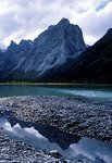 Canadian Mountain Range at the Nahanni National Park Reserve, a World Heritage Site. (Source: Nahanni National Park)
 The park's administration is headquartered at Fort Simpson, and there is a year-round operations center at Nahanni Butte. A management plan drawn up in 1987 was designed to serve for a 15 year period with a five yearly review. The park has been zoned: Zone I, Special Preservation, is an area where no motorized or manual facilities are permitted. Seven areas in Nahanni including several hot springs, sheep licks and the Sand Blowouts are in this zone. Zone II, Wilderness, preserves wilderness environments and comprises the entire South Nahanni and Flat River corridors with the exception of the immediate Virginia Falls area and Rabbitkettle Lake. Zone III, Wilderness Recreation, is intended for areas maintained as natural environments, but which can sustain a selected range of low density outdoor activities; it includes Rabbitkettle Lake and Virginia Falls. The zoning policy takes native resource harvesting and other native traditional activities such as hunting, fishing and trapping into consideration.
Expansion of the Park is planned over the Tlogotsho Plateau, Ragged Range and a karst landscape north of Virginia Falls to better represent the region and protect the ecological integrity of the Park. The Deh Cho Process of the Deh Cho (Big River) First Nations who represent native peoples of the Mackenzie river basin is involving them with Parks Canada in the planning to preserve and extend the protected wilderness. Their land claims process will be used to help determine the extended protected area and buffer zones and to counter mining proposals upstream from the Park.
Management constraints
The Mackenzie Valley Environmental Review Board has still not resolved conflicts over land use and policy concerning the Park. The present park is essentially a corridor which omits most of the river’s watershed and much habitat necessary to the area’s wildlife. To mining and oil and gas exploration interests the region is a rich source of raw minerals awaiting development and there are several old mines and ongoing mineral explorations within the South Nahanni watershed. Moreover, the government organization in charge is the Department of Indian and Northern Affairs which combines environmental protection with the promotion of industrial development of the Territory. However, in the event of floods or earthquake, to which the region is prone, mining in the watershed of the Park will almost certainly pollute its waters, affecting the fisheries (Fisheries and aquaculture) which have a relatively low natural productivity. Recently proposed zinc and lead mining at a site on Prairie Creek 15 km upstream, already partly developed for silver mining, threatens the integrity of the site with contamination by cyanide, arsenic, antimony and mercury. Proposed reopening of a tungsten mine 45 km up the Flat River from the Park may also risk polluting the rivers. Park staff are working with outside stakeholders such as the Deh Cho First Nations in the Greater Nahanni Ecosystem to mitigate the potential threats.
Staff
9.3 person-years for fiscal year 1994.
Budget
C$278,000 is granted for operation and maintenance; capital in 1995 was C$149,000.
IUCN management category
- II (National Park)
- Natural World Heritage Site, inscribed in 1978: one of the first World Heritage sites. Natural Criteria ii, iii
Further reading
- Addison, W. (1974). A Review of the Biophysical Lliterature Pertinent to Nahanni National Park and the South Nahanni Watershed. Unpublished manuscript. 226 pp.
- Amsden, C. (1978). A Preliminary Archaeological Assessment of Nahanni National Park and Vicinity. Manuscript Report Series Number 277. Parks Canada, Ottawa.
- Brook, G. (1976). The Karst Lands of the South Nahanni Region, Mackenzie Mountains, N.W.T. Ph.D. Thesis, McMaster University, Hamilton.
- Cairns, A.,Henry, J. & Scotter, G. (1978). Vegetation, Wildlife, and Recreation Assessment of the Flat-South Nahanni Rivers Confluence Area, Nahanni National Park. Unpublished Report, Canadian Wildlife Service, Edmonton.
- Canadian Parks and Wilderness Society (CPAWS) (2001). Greater Ecosystem Key to Protecting Nahanni's Future.
- Chadwick, D. (1981). Nahanni: Canada's wilderness park. National Geographic. Vol. 150, No.3.
- Cody, W.,Scotter, G. & Talbot, S. (1979). Additions to the vascular plant flora of Nahanni National Park, Northwest Territories. Naturaliste Canadienne 106:439-450.
- Ford, D. (1974). Final Report on the Geomorphology of South Nahanni National Park, N.W.T. Hamilton, Ontario, McMaster University.
- Halliwell, D. & Catto, S. (1998). Protecting the Aquatic Quality of Nahanni National Park Reserve, N.W.T. Environment Canada and Parks Canada. 85 pp.
- Harding, L. (1980). A canoeist's exploration of Nahanni Park", Canadian Geographics. Vol. 100, No.3.
- IUCN (2001). Report on the State of Conservation of Natural and Mixed Sites Inscribed on the World Heritage List and the List of World Heritage in Danger. Gland, Switzerland.
- IUCN (2002). Report on the State of Conservation of Natural and Mixed Sites Inscribed on the World Heritage List. Gland, Switzerland
- Joweet, P. (revised 1998). Nahanni, the River Guide. Rocky Mountain Books, Calgary. ISBN: 1894765400.
- Keogh, P. & R. (1988). The Nahanni Portfolio. Stoddart/Nahanni, Don Mills ON. ISBN: 0773721673.
- Marsh, A., & Scotter, G. (1975). Vegetation Survey and Impact Assessment of the Nahanni Hotsprings and Virginia Falls Areas, Nahanni National Park. Unpublished Report, Canadian Wildlife Service, Edmonton.
- Moore, J. (revised 2000). Nahanni Trailhead, Hancock House Publishing, Surrey, BC. ISBN: 0888394640.
- Neely, L. (1978). The Nahanni: Land of Myth and Mystery.
- Parks Canada (1987). Nahanni National Park Reserve Management Plan. Canadian Heritage Parks Canada. 68 pp.
- Parks Canada (1994). Nahanni National Park Reserve of Canada. 20 pp.
- Parks Canada (2001). Nahanni National Park Reserve. Natural Resource Conservation Section, Parks Canada, Winnipeg. 9pp.
- Scotter, G.,Simmons, N.,Simmons,H. & Zoltai, S. (1971). Ecology of the South Nahanni and Flat River Areas. Unpublished Report, Canadian Wildlife Service, Edmonton.
- Scotter, G. & Cody, W. (1974). Vascular Plants of Nahanni National Park and Vicinity, Northwest Territories. Naturaliste Canadien 101:86l.
- Scotter, G. & Simmons, N. (1975). Nahanni: Wilderness Revealed, Legend Preserved.
- Scotter, G.,Carbyn, L. Neily, W. & Henry, J. (1985). Birds of Nahanni National Park, Northwest Territories. Special Publication No.15, Saskatchewan Natural History Society, Regina
- Spence, C. (1998). An Overview of River Conditions for South Nahanni River Basin, NWT. Environment Canada. 28 pp.
- Steere, W.et al. (1977). Bryophytes of Nahanni National Park and vicinity, Northwest Territories, Canada. Canadian Journal of Botany, 55(13): 1741.
- Steere, W. & Scotter, G. (1978). Additional bryophytes from Nahanni National Park and vicinity, Northwest Territories, Canada. Canadian Journal of Botany 56:234-244.
- Vitt, D. & Horton,D. (1979). Mosses of the Nahanni and Liard river area, southwestern Northwest Territories, Canada. Canadian Journal of Botany 57:269-283.
- UNESCO World Heritage Committee (2002). Report on the 26th Session of the World Heritage Committee, Paris.
| Disclaimer: This article is taken wholly from, or contains information that was originally published by, the United Nations Environment Programme-World Conservation Monitoring Centre (UNEP-WCMC). Topic editors and authors for the Encyclopedia of Earth may have edited its content or added new information. The use of information from the United Nations Environment Programme-World Conservation Monitoring Centre (UNEP-WCMC) should not be construed as support for or endorsement by that organization for any new information added by EoE personnel, or for any editing of the original content. |