Drainage basin
| Topics: |
Geology (main)
|

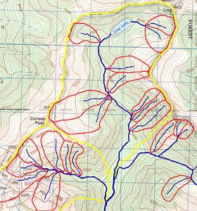
Geomorphologists and hydrologists often view streams as being part of drainage basins. A drainage basin is the topographic region from which a stream receives runoff, throughflow, and groundwater flow. Drainage basins are divided from each other by topographic barriers called a watershed (Figure 1). A watershed represents all of the stream tributaries that flow to some location along the stream channel. The number, size, and shape of the drainage basins found in an area varies with the scale of examination. Drainage basins are arbitrarily defined based on the topographic information available on a map. The quality of this information decreases as map scale becomes smaller.

Drainage basins are commonly viewed by scientists as being open systems. Inputs to these systems include precipitation, snow melt, and sediment. Drainage basins lose water and sediment through evaporation, deposition, and streamflow. A number of factors influence input, output, and transport of sediment and water in a drainage basin. Such factors include topography, soil type, bedrock type, climate, and vegetation cover. These factors also influence the nature of the pattern of stream channels (Figure 2).
Dentritic drainage patterns are like tree branches and repesent the most common drainage pattern. Trellised drainage patterns tend to develop where there is strong structural control upon streams because of geology. In such situations, channels align themselves parallel to structures in the bedrock with minor tributaries coming in at right angles. Areas with tectonic faults or bedrock joints can cause streams to take on a grid-like or rectangular pattern. Parallel drainage patterns are often found in areas with steep relief or where flow is over non-cohesive materials. Dendritic patterns are typical of adjusted systems on erodable sediments and uniformly dipping bedrock. Deranged drainage patterns are found in areas recently disturbed by events like glacial activity or volcanic deposition. Over time, the stream will adjust the topography of such regions by transporting sediment to improve flow and channel pattern.
Drainage basin analysis is important to define some factors as the basin shape,stream frequency, drainage density and stream length. These factors help for water runoff feed to groundwater. Also, Drainage basin analysis helps in water harvest and definning sites for dykes or dames to retard the flash floods or storing water.
Further Reading