Ichkeul National Park, Tunisia
| Topics: |
Contents
- 1 Introduction
- 2 Threats to the Site
- 3 Geographical Location
- 4 Dates and History of Establishment
- 5 Area
- 6 Land Tenure
- 7 Altitude
- 8 Physical Features
- 9 Climate
- 10 Vegetation
- 11 Fauna
- 12 Cultural Heritage
- 13 Local Human Population
- 14 Visitors and Visitor Facilities
- 15 Scientific Research and Facilities
- 16 Conservation Value
- 17 Conservation Management
- 18 IUCN Management Category
- 19 Further Reading
Introduction
Ichkeul Nation Park (37º 10'N, 09º 40'E) is a World Heritage Site located in northern Tunisia. Lake Ichkeul is the last of a chain of shallow freshwater lakes which once extended all along the northern African seaboard. The lake and its surrounding marshes (Non-tidal marsh) are important for the extremely high numbers of wintering Palaearctic waterfowl: ducks, geese, storks and pink flamingos among others which feed and nest there. It is eutrophic and brackish. but seasonally expanded by floodwaters.
Threats to the Site
Construction of three dams on rivers supplying the lake has cut off almost all the fresh water inflow, causing a destructive increase in their salinity. Reed beds, sedges and other fresh-water species have been replaced by halophytes, causing a sharp reduction in the numbers of migratory birds which depended on the former habitat; all reed-dependent species such as purple heron, purple gallinule and reed warblers have disappeared. There is also agricultural encroachment onto the marshes.
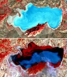 Lake Ichkeul, Tunisia. The lake badly deteriorated as the result of the construction of three dams on rivers supplying it and its marshes. The dams cut off almost all inflow of fresh water, causing a destructive increase in the salinity of the lake and marshes. The two ASTER 3-2-1 RGB composites depict vegetation in shades of red. In 2005 (bottom) the water level is higher than 2001 (top), but a large part of the lake appears red due to the presence of aquatic plants. (Source: NASA/GSFC/METI/ERSDAC/JAROS, and U.S./Japan ASTER Science Team)
 In 1996 the Park was inscribed on the List of World Heritage in Danger. However, in June 1998 the IUCN (World Conservation Union (IUCN)) observed that the salinity of the lake water may have exceeded any chance of recovering the World Heritage values of the site. IUCN expressed its concern at the slow pace and lack of effectiveness of the rehabilitation program by the State Party and the World Heritage Committee recommended an expert mission to investigate the development of additional measures to rehabilitate Ichkeul and to determine the progress of mitigation by the Tunisian authorities.
Geographical Location
Ichkeul National Park is in northern Tunisia on the plain of Mateur, 15 kilometers (km) southwest of Bizerta, 10 km north of Mateur, and ~15 km south of the Mediterranean at 37º 10'N, 09º 40'E.
Dates and History of Establishment
- 1891: Jebel Ichkeul acquired by the state government. 1926: All Garaet el-Ichkeul became state property.
- 1974: Most of the Ichkeul marshes ceded to the Direction des Forêts in 1974 for conservation.
- 1977: Recognised as a Biosphere Reserve under UNESCO's Man and the Biosphere Program.
- 1980: National Park status for the area ratified by Presidential Decree No. 80-1608; Designated a Wetland of International Importance under the Ramsar Convention.
- 1990: Included on Ramsar Convention Montreux record of Heritage sites undergoing change.
Area
Lac Ichkeul: ~12,600 hectares (ha); Jebel Ichkeul: 1,363 ha. The lake, normally about 8,700 ha, may flood the surrounding marshes (Non-tidal marsh) to ~11,400 ha in the rainy season .
Land Tenure
The lake, mountain and some marshland are state property, owned by La Direction des Forêts, La Direction des Ressources en Eau and Les Terres Dominiales; most of the marshland is private. Six government departments have responsibility for different aspects of the Park: administration, lake waters, marshland, fisheries (Fisheries and aquaculture), agriculture and environmental planning.
Altitude
From 1.5 meters (m) below sea level (lake bottom) to 511 m at the top of Jebel Ichkeul.
Physical Features
The park is comprised of two physiographic units: an isolated wooded mountain and a permanent brackish water lake surrounded by marshland. The lake varies from ~0.9 m deep in summer to ~2.5 m deep in winter, and can extend up to 2,700 ha over the marshes surrounding it on the south, west and northwest (extending from ~6 km long to ~15 x 5km wide). The lake is connected to the sea via the Oued Tinja canal leading to a marine lagoon, Lac de Bizerte. It is fed by six main rivers, from the west and south: Oueds Douimis, Sejenane, Malah, Rhezala, Joumine (canalized across the marshes) and Tine, a tributary of the Joumine. These dry out in summer when a lack of freshwater, high levels of evaporation and inflowing seawater cause the lake level to fall and its salinity level to rise. From July to October the salinity can be as high as 38 gm per liter; after the autumnal rains it can fall as low as 1.7 gm per liter. Drought from 1999-2002 caused its salinity to rise to twice that of the sea. The lake basin and marshland soils are alluvial. The mountain, Jebel Ichkeul, is composed of Triassic and Jurassic metamorphosed limestones with fossiliferous pseudo-dolomitic marbles exposed in quarries on its south-western slopes.
Climate
The climate is typically Mediterranean. The mean monthly January temperature is 11.3ºC and winter minimum 0ºC. The mean monthly July temperature is 25.2ºC and the summer maximum 40ºC. The average annual rainfall is 625 millimeters (mm), only 4 per cent falling in summer. About 300 million cubic meters (m3) of rainwater per year entered the lake when first measured, but between 1996-2003 damming and drought drastically diminished its freshwater supply. Rainfall was plentiful during the winter of 2002-2003 and the dry marshlands were flooded once more.
Vegetation
The park has a typically semi-arid flora of about 400 species dominated by pan-Mediterranean plants. Distinct habitat types within the park include the mountain and its foothills, the freshwater marshes, the lake and reed beds, eutrophic and subject to fluctuating salinity, and well-drained lowland ridges. This wide range of habitats attracts a great variety and number of waterbirds, both resident and migrant.
The mountain is dominated by a woodland of wild olive Olea europea and fairly dense maquis of lentisc Pistacia lentiscus with Phillyrea angustifolia and Smilax aspera, also by open maquis with Euphorbia dendroides co-dominant on south-eastern slopes, and Juniperus phoenicea on northern slopes. Chamaerops humilis grows on rocky ridges. Other mountain shrubs are carob Ceratonia siliqua, Tetraclinis articulata (R) and Cistus salvifolius . A rich variety of northern Tunisian plant species includes the endemic Teucrium schoenenbergeri and Crypsis aculeata.
The vegetation of the area is distinctly zoned. The lake was fringed by a belt of Phragmites communis reeds. Growing submerged in the marsh pools and low salinity open water are narrow-leaved pondweed Potamogeton pectinatus, Zannichellia palustris, Ekebergia spp., Callitriche spp. and Ruppia maritima. The potamogeton used to be abundant in the west of the lake, covering a third of the lake, and was the major food of some 200,000 wintering and migrant waterbirds. It is being replaced by more salt-tolerant and less palatable species such as Ruppia cirrhosa.
Further inland the marshland is dominated by cordgrass Scirpus maritimus and S. litoralis which are the main food of greylag geese, require annual inundation and are not salt-tolerant; also Juncus subulateus. These are being replaced by more halophytic Ammi visnaga and Scolymus maculatus. Ranunculus ophioglossifolius and Sparganium erectum, recorded at only a few sites in Tunisia, also grow in the marshes. The unique lake and freshwater vegetation of Joumine and Malah marshes ranges from emergent plant associations such as Scirpus lacustris, Typha angustifolia and Phragmites communis through a belt of halophytes, Salicornia arabica, Suaeda maritima and Arthrecnemum fruticosum to grass pastures with shrubby Tamarix africana. In drier areas and on the well drained ridges are associations of Hordeum maritimum with Lolium multiflorum and Daucus carota or Nerium oleander and Ziziphus lotus.
Fauna
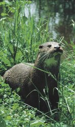 Otter (Lutra lutraI). (Source: U.K. Environment Agency)
 The Ichkeul wetland is the most productive wetland for waterfowl in North Africa and one of the most important sites in the entire Mediterranean region (Mediterranean Basin) for wintering Palaearctic species, with past records of up to 300,000 to 400,000 birds present at one time. 226 species of birds including 34 breeding residents were recorded by Skinner et al, in 1986. The most numerous species are wigeon Anas penelope (39,000:112,000 in the1970s), common pochard Aythya ferina (120,000 in 1971) and coot Fulica atra (36,000:188,000 in 1973). High records for common pochard and greylag goose Anser anser (3,200: 18,000 in the 1970s) show that Ichkeul is their most important wintering site in northwest Africa. 600 (4% of known world population) of the threatened white-headed duck Oxyura leucocephala, were seen in 1977. Other wintering wetland birds include the threatened marbled teal Marmoronetta angustirostris, ferruginous duck Aythya nyroca, and corncrake, Crex crex; also high numbers of green-winged teal Anas crecca, northern pintail Anas acuta, northern shoveler Anas clypeata and black-winged stilt Himantopus himantopus. Flamingoes Phoenicopterus ruber summer on the lake. However, by 2002 as a result of the lack of freshwater and subsequent inflow from the sea, the waterfowl population of the lake was mostly of salt-tolerant species. Other birds include Egyptian vulture, Neophron percnopterus, Bonelli's eagle Hieraaetus fasciatus, booted eagle H. pennatus, marsh harrier Circus aeruginosus, lanner falcon Falco biarmicus, peregrine falcon Falco peregrinus (threatened), collared pratincole Glareola pratincola and Moussier's redstart Phoenicurus moussieri. Migrant marsh harrier Circus cyaneus and reed warbler Acrocephalus scirpaceus are common, also the threatened migrant white stork Ciconia ciconia. The rare black stork Ciconia nigra and glossy ibis Plegadis flacinellus are recorded.
One of the most notable of the mammals recorded at Ichkeul is the otter Lutra lutra which has been hunted for its meat. Less than ten animals were believed to exist at the time of survey. Of the larger mammals there are large populations of wild boar Sus scrofa, and introduced wild water buffalo Bubalus bubalis; also a number of crested porcupine Hystrix cristata (LR), jackal canis aurea, genet Genetta genetta, Egyptian mongoose Herpestes ichneumon, wild cat Felis sylvestris lybica; and four species of bat. Lists of fauna are recorded in the London University College report.
The herpetofauna varies with water level and salinity. The marsh frog Rana ribibunda is common in the marshes. There are also painted frog Discoglossus pictus , three species of toad, two harmless species of snake and one lacertid. Two pond turtles, Iberian Clemys leprosa and European Emys orbicularis are found in the lake.
The lake and marshes, especially the dense Potamogeton beds, support huge populations of a few species of marine and brackish water invertebrates. Species include Nereis diversicolor, Gammarus locusta, Corophium volutator, Sphaeroma hookeri, Idotea spp., Hydrobia spp., Abra spp. and Cerastoderma glaucum; freshwater invertebrate species also occur on the edge of the salt marsh. Shore crab Carcinus mediterraneus and Balanus amphitrite occur near the Tindja canal.
The principal fish dependent on this teeming life are eel Anguilla anguilla, mullets Mugil cephalus and M. ramada, sole Solea solea, sea bass Dicentrarchus labrax, barbel Barbus barbus, shad Alosa fallax and anchovy Engraulis encrasicholus. In shallow water Mediterranean killifish Aphanius fasciatus and seahorse Syngnathus abaster are found.
The site has internationally important Pleistocene (Villafranchian) fossil deposits in late Tertiary and early Quaternary outcrops on the northern shore. They include unique assemblages of mammal remains, notably hominid and primate records, but also bones of Elaphas planifrons, Stylohipparion libycum, Libytherium maurusium, Anacus osiris, Testudo gigans and T.emys.
Cultural Heritage
The lake, marshes and mountain have been settled by man for millennia. In Carthaginian times Lake Ichkeul surrounded the mountain. A nearby Roman mosaic depicts a purple gallinule porphyrio porphyrio, which bred in the reed beds until a decade ago. In 1240 Jebel Ichkeul and the lake were already managed as a hunting reserve. Water buffalo were present then, and were certainly introduced from Italy in 1729. The herd was decimated in 1957 for food but has recovered. Lake sedimentation and the subsequent growth of Potamogeton increased in the late C19th with increased farming and the cutting of the Bizerta ship canal in 1895.
Local Human Population
The area immediately around the park is very densely populated, with the towns of Bizerta, Mateur and Menzel Bourguiba 15,10 and 5 km away respectively and Tindja village on its eastern edge. The government is committed to a plan for the improvement of the Mateur plain which requires the local water for drinking and irrigation. Hunting, fishing, grazing and quarrying are officially illegal within the Park. However, there are up to 2,500 cattle, sheep and goats and 800 ha of cultivation within the park boundary. On its fringes there are intensive arable farming, orchards and pasture. The village on the park boundary near the quarry is growing and may absorb the 130 families squatting in the park. Most of these are employed in the large illegal stone and gravel quarries on the southern and northwestern slopes of J.Ichkeul. The local fishery (Fisheries and aquaculture), run by the government, produces 200 tonnes per year.
Visitors and Visitor Facilities
After the Direction des Forêts and the Tourist Directorate extensively promoted natural history tourism, 23,000 visited the park in 1987 and more than 2,500 people visited the area over six weeks in spring 1988. These included 41% in school groups and 6.6% foreign tourists. Many locals visit the hot springs (hammams) on the northeastern edge of the mountain. An eco-museum and information center built with the help of the British Museum for Natural History and the WWF opened in spring 1989. The visitor facilities, including exhibits and audio-visual displays are also sited on the northeastern corner of the Jebel. There are no accommodations or camping facilities within the park.
Scientific Research and Facilities
Some of the earliest scientific studies were the palaeontological excavations in1947-49. Stratigraphic and palaeontological studies were carried out by the Tunisian National Bureau of Mines. Research on Lake Ichkeul was done by the University of Tunis, the Institut National Scientifique et Technique d'Océanographie et de Pêche, Tunis (INSTOP) and University College London. A program of waterfowl observations by University College London with IWRB, Slimbridge and the Tour de Valat CNRS Biological Station, Camargue, France, has run since 1963. These consultants recommended a series of measures to manage the lake's water regimen. Research facilities in the park opened at the eco-museum in the 1990. The Ramsar Convention Bureau sent out Advisory Missions in 1988,1989 and 2000.
Conservation Value
Garaet Ichkeul is the last of a chain of lakes which used to extend across the north African littoral and one of the four most important remaining wetlands in the western Mediterranean. The national park was created to safeguard this wetland with its [../150560/index.html diversity of terrestrial and aquatic ecosystems. The lake and marshes are of particular importance for the extremely high numbers of wintering Palaearctic waterfowl which still totaled over 90,000 in 1999/2000 and included globally threatened species. The park also protects important fossil mammal deposits and is scenically beautiful. Decreasing the freshwater supply will eventually convert it into a seawater lagoon.
Conservation Management
A management plan developed in 1977 was incorporated into the National Park statutes. The most important objectives were to control the water level and salinity of the lake and to maintain and develop the pondweed Potamogeton, the major food source for wintering and migrating waterfowl. The EEC and the French Ministry of the Environment, funded a management study between 1982 and 1985 by University College, London, the IWRB, the Tour du Valat station and consultant engineers SOGREAH to counter the effects of dams and canalizing on the lake and marshland. This initiated designs for a sluice on Oued Tindja to control water salinity by restricting seawater entry and containing the loss of freshwater which was built by 1996. It condemned the dredging and embankment of the Joumine and Malah canals which dry out the marshes, encourage halophyte growth and access by poachers, and recommended a visitor center and cleaning up pollution from the hammams.
In 1996 the Tunisian Ministry of the Environment commissioned a report on measures to reverse the degradation; some have been taken. Three smaller proposed dams have been canceled for the time being, water from existing dams is to be released to the lake and a pumped supply from Sidi El-Barrak dam (127 km west) may be made available but the necessary pumping station had not been built by 2002. The quarries are to be closed and water treatment plants installed for nearby towns. Government action is to include agreement among the six departments responsible for making decisions about the area of the Park, for water supply, rural engineering, fishing, grazing and agriculture, forestry, local [[population]s] and environmental planning. The canals were to be filled in and the marsh restored. A scientific committee from all the researchers studying the park was to be convened. Monitoring of the water, lake siltation, flora and bird species were to be continued and the analysed information made available to decision-makers. A government report of 2001 summarizing measures for the lake's protection was taken by the IUCN as the basis for establishing the appropriate conditions for annual monitoring and rehabilitation, for which funding was requested; and in 2003 the [[Tunisia]n] government asked the IUCN and the Centre for Mediterranean Cooperation for help in restoring the lake with funding from UNESCO.
Management Constraints
The site was placed on the List of World Heritage Sites in Danger in 1996 because dams built upstream had cut off nearly all the flow of fresh water to the lake. This had greatly increased its salinity, dried up the marshes allowing livestock to degrade them, and caused a very serious loss of biological diversity. It altered the food chain by greatly reducing the area of Potamogeton - in 1988/9, from 3,000 to 500 ha. With replacement at the same time of Scirpus maritimus and Phragmites by more salt tolerant species, there was a potential loss of 20 percent of the marshland food plants. Reed-dependent species have disappeared with the lakeshore reed beds, and the number of migrating birds has declined. Wintering waterfowl and greylag goose numbers have decreased from 200,000 to 50,000 and 20,000 to less than 1,000 respectively.
The park director still lacks sufficient authority, budget, clear park boundaries, a trained and uniformed staff and an updated management plan. An adequately funded administrative structure advised by a team of scientists is needed to implement the integrated management plan drawn up by the ANPE report team and monitor development. A workshop was held in January 2003 to develop the options for a sustainable future for the lake which again emphasized the need for an enforceable management plan, and the installation of a water regime favorable to the lake. However, the Ministry of Water Resources could only promise 20-25 million m3, a quarter of that needed.
There are still six government departments with different responsibilities for and attitudes towards the Park. The marsh canals are unreclaimed through fear of the effect on groundwater, and stone quarries which provide work but have degraded much of the south side of the Park still operate. The families (~1000 people) squatting in the park are still the cause of overgrazing and land clearance. The whole area is under threat from commercial fishing, logging, poaching, agricultural expansion, and pollution by pesticides, fertilizers and tourism. After heavy winter rain, the ecosystem partially recovers and the number of birds wintering in the west end of the lake increases, but numbers are still low. However, the whole area of and around both lake and mountain, the bird [[population]s] and the World Heritage status of the Park all remain at risk from the effects of global warming, lack of rainfall and inadequate mitigation.
Staff
A National Park director and wardens have been appointed, based in the Commissaire Regional au Developpement Agricole de Bizerte (CRDA).
Budget
The gross annual budget allocated for the park averaged DT16,000. The EEC and French Ministry of the Environment funded the 1982-85 management study by University of London, the IWRB and the Tour du Valat station. The eco-museum was built with assistance from the WWF; the World Heritage Fund donated a vehicle for Park surveillance. In 2002 the WWF gave an emergency grant of $50,000 for a workshop, held in January 2003, to improve the monitoring of the rehabilitation of the lake to be summarized in a report to be submitted later in 2003.
IUCN Management Category
- II National Park. Biosphere Reserve. Ramsar site.
- Natural World Heritage Site, inscribed in 1980. Natural Criterion iv.
- Listed as World Heritage in Danger in 1996 because the freshwater supply has been dammed, turning the lake salt.
Further Reading
- André, H. (1953). Le lac Ichkeul, étude hydrogéologique. Archives du Ministère de l'Agriculture. Tunis. 6.
- Anon. (1988). Two Problematical National Parks in the Mediterranean Region. Field Report.pp.3.
- ANPE (Agence Nationale pour la Protection de l'Environnement) (1996). Etude pour le Sauvegarde du Parc National d'Ichkeul. Report prepared for the Ministry of the Environment, Tunis.
- Arambourg, C.& Arnould, M. (1949). Notes sur les fouilles paléontologiques exécutées en 1947, 1948 et 1949 dans le gisement Villafranchian de la Garaet Ichkeul. Bulletin de la Société des Sciences Naturelles de Tunisie, II.
- Baccar, H. (1982). The Role of Ichkeul National Park in Conserving Genetic Resources. Report for the Commission on National Parks and Protected Areas/IUCN.
- Baccar, L.,Smart, M.,Tiega, A & Triplet, P.(2000). Ramsar Advisory Mission Report No.41. Report on a Mission to Ichkeul National Park, 28 Feb.-4 March, 2000, Ramsar Convention Bureau.
- Bel Hadk Kacem, S. (1985). La Conservation de la Faune et de la Flore Sauvages en Tunisie. Seminaire sur la Conservation du Patrimoine Forestier National, Octobre 1985 à l'INPPSA de Sidi-Thabet.
- Bousquet, B. (1988). Rapport de Mission du Parc National de l'Ichkeul et Autres Aires Protegees de Tunisie Septentrionale et Centrale. MAB-UNESCO et Fonds du Patrimoine Mondial.
- Carp, E. (1980). A Directory of Western Palaearctic Wetlands. IUCN, Gland, Switzerland. ISBN: 2880323002.
- Drucker, G. (1987). Protected areas of Tunisia. Unpublished report. Sussex, England.
- El-Hamrouni, A. (1986). Parcs naturels et réserves de la biosphère en Tunisie. Plan d'action pour les réserves de la biosphère dans la région Méditerranéenne. Atelier de Florac (MAB), 9-12 Sept.1986.
- Grimmett, R. (1987). A Review of the Problems Affecting Palaearctic Migratory Birds in Africa. ICBP, Cambridge, U.K.
- Gryn-Ambroes, P. (1980). Preliminary Annotated Lists of Existing and Potential Mediterranean Protected Areas. UNEP/IUCN report. UNEP/IG.20/INF5.
- Hollis, G. (ed.) (1977). A Management Plan for the Proposed Parc National de l'Ichkeul, Tunisia. Conservation Report No. 10. Ecology & Conservation Unit, University College, London.
- Hollis, G. et al. (1986). The Modelling and Management of the Internationally Important Wetland at Garaet el Ichkeul, Tunisia. Ecology & Conservation Unit, University College, London for the Ministère de l'Agriculture, Tunis. IWRB special publication No.4,Slimbridge,Glos,U.K. 121pp.
- INRAT (1967). Carte phyto-ecologique de la Tunisie septentrionale. Annales de l'Institut National de la Recherche Agronomique de Tunisie, Vol. 40 fasc. 1 Tunis. 340 pp.
- IUCN (1996) Monitoring the State of Conservation of Natural World Heritage Properties. Report prepared by IUCN for the 20th session of the World Heritage Committee, Dec.1996, Mexico.
- IUCN (1997) State of Conservation of Natural World Heritage Properties. Report prepared by IUCN for the World Heritage Bureau, 21st session, UNESCO, Paris, 23-28 June. 7pp.
- IUCN/WCPA (2003). World Heritage Spotlight. Restoring Ichkeul Through Sharing Knowledge.
- Johnson, A. & Hafner, H. (1972). Denombrement de Sauvagine en Automne sur des Zones Humides de Tunisie et d'Algérie. Station Biologique de la Tour du Valat, le Sambuc, France.
- MAB Bureau (1977). Parc National de Ichkeul. Biosphere Reserves MAB, Project 8.
- Maaher A. (1984). National Parks and Natural Reserves in the Arab World. Arab League of Education, Culture & Science Organisation (ALECSO). Report 80/001/ 1984, Science division, Tunis.
- Mezzi, F. (1988). Jebel Ichkeul défend son cadre de vie. La Presse. 2 Janvier 1988.
- Ministère de l'Agriculture (1980). Parcs Nationaux de Tunisie. L'Ichkeul. Ministere de l'Agriculture, Direction Generale des Forets. Tunis.
- Morgan, N. (1982). An ecological survey of standing waters in North-west Africa: II Site descriptions for Tunisia and Algeria. Biolological Conservation 24: 83-113.
- Müller, H. (1970). Die wasserbuffel Tunisiens. Säugetierliche Mitteilungen 18 Jhg. Heft 3.
- Office National des Mines (OMN) (1976). Contributions a l'Etude Stratigraphie et Paleontologique de Djebel Ichkeul. Office Nationale des Mines, Tunisie.
- Patterson, J. (1989). Conserving Lake Ichkeul. IWRB News. No. 1.
- Posner, S. (1988). Biological Diversity and Tropical Forests in Tunisia. Report prepared for the Washington D.C. and Tunis Offices of the Agency for International Development.
- Riney, T. (1964). Potential Use of the Wildlife Resource on Tunisian Forest Lands. Report to the Government of Tunisia. FAO, Rome.
- Scott, D. (1980). A Preliminary Inventory of Wetlands of International Importance for Waterfowl in Western Europe and North-west Africa. IWRB special pub. no 2. 127 pp.
- Skinner, J. (1985). Lake in the desert. Birds 10(7): 29-33.
- Skinner, J.,Rehfisch, M.Wood, J.Fay, Smart, M.& Gauthier T. (1986). The Birds of the Ichkeul National Park, Tunisia. Conservation Reports No. 13. University College, London.
- Smart, M. (1974). The Wetlands of North Africa and Their Importance to Waterfowl. IWRB. Slimbridge,U.K.
- Smart, M. (1975). Recensement des Oiseaux D'eau en Tunisie, Janvier 1975. IWRB report, Slimbridge,U.K.
- Smart, M. (1988). Ramsar Advisory Mission: Report No.3,Ichkeul,Tunisia. Ramsar Conv. Bureau.
- Smart, M. & Hollis,G. (1989). Ramsar Advisory Mission: Report No.15, Ichkeul, Tunisia. Ramsar Convention Bureau.
- Stevenson, A., (1991). Palaeoecological and documentary records of recent environmental change in Garaet El Ichkeul. Biological Conservation. 58:275-95.
- Tamisier, A. (1988) Ichkeul, Parc National. Etat des Lieux en 1988. Report to UNESCO from Director of Research, CNRS, Arles, France
- UNESCO, World Heritage Committee (2001). Report on the 25th Session of the World Heritage Committee, Paris.
- UNESCO, World Heritage Committee (2002). Report on the 26h Session of the World Heritage Committee, Paris.
- Warren, A., Hollis, G., Wood, J. Hooper, M. & Fisher, R.C. (1979). Ichkeul, the problems of a wet park in a dry country. Parks 4(3): 6-10.
- WWF (1987). List of Approved Projects, March 1987. Vol. 4. p.131.
- Zaouli, J. (1976). Contribution à L'étude Ecologique du Lac Ichkeul. INSTOP, Tunis.
| Disclaimer: This article is taken wholly from, or contains information that was originally published by, the United Nations Environment Programme-World Conservation Monitoring Centre (UNEP-WCMC). Topic editors and authors for the Encyclopedia of Earth may have edited its content or added new information. The use of information from the United Nations Environment Programme-World Conservation Monitoring Centre (UNEP-WCMC) should not be construed as support for or endorsement by that organization for any new information added by EoE personnel, or for any editing of the original content. |