Ecuadorian dry forests
Introduction
The Ecuadorian dry forests ecoregion is considered an area of great biological importance due to the number of species and high levels of endemism present. For this reason and due to the impact of human activity, it has been classified as an ecoregion with maximum regional conservation priority.
Location and General Description
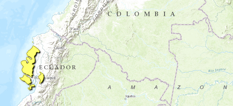
The Ecuadorian dry forest ecoregion extends along the Pacific coast southward from southern Esmeraldas province in northern Ecuador into the Guayas province, ending at the Golfo de Guayaquil. The ecoregion is not one continuous strip however, it has outliers one lies east of the mouth of the Guayas River past grasslands nearer the foothills of the Andes Mountains while a second is on Puná Island in the Golfo. Suprisingly this dry forest is bordered by the complete opposite, a moist forest ecoregion that receives at least 2,000 millimeters (mm) of rain each year. It is isolated from similar dry forest habitat formations found in the Caribbean and Brazil yet is connected in terms of its flora with northwestern Peru. This isolation is probably responsible for the high level of endemism. Characterized by lowlands with elevations of less than 300 meters (m), although some parts of the ecoregion reach elevations above 800 m.
Vegetation such as desert scrub, intermontane thorn-forest, and deciduous and semi-deciduous forest, which in the northern part of the ecoregion is mainly found below 600 m, but in the southern areas where less than 1000 mm of precipitation a year is received, it ascends to an elevation of 2000 m. Average precipitation ranges from 300 to 1500 mm per year, but there are great fluctuations between years. In "El Niño" years, which occur at 3-16 year’s intervals, rainfall may be 200 times as high as a very dry year. In normal years the dry and rainy seasons occur as very marked seasons; 90% of rainfall is concentrated in the months between December and May, although the most falls in March. The temperature increases during the dry season increasing the effects of very low amounts of rainfall. This ecoregion depends heavily on the duration of the rainy season for plant growth and reproduction activities. The climate of this zone is directly related to the presence of the cold Humboldt current and the warm El Niño and Panama currents. At low elevations the mean annual temperature varies between 24 and 26° C and changes over the year are small (in the order of 1-3 °C). Daily fluctuations are about 10-15 °C.
Soils consist primarily of volcanic material mixed with small amounts of marine strata. These are mostly sandy, clayey or formed from volcanic stones. Only locally in the south, contains both pre-Cretaceous metamorphic rock and granite of similar age. In the Tertiary period, the [[coast]al] range emerged. It is the natural eastern limit of the dry forest in the northern part of the ecoregion. The Chongón-Colonche range is the major mountain group of the ecoregion, and lies in a primarily southeast-northwest direction. These foothills form basins of small rivers that emerge primarily in the rainy reason. An important source of moisture in these mountains is the sea mist known as Garúa that forms during the austral winter which condenses at higher elevations. West of the coastal range the dry tropical forest becomes tropical rainforest, without a clearly discernible transition zone.
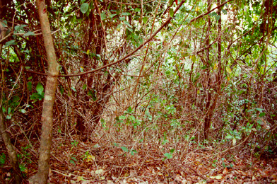
These topographical conditions create an altitudinal gradient that is reflected in the characteristics of the vegetation in the dry forest, which despite what might be expected has higher rates of regeneration and growth than the wet forests, a favorable aspect for its natural regeneration. The southwest zone is more affected by the Humbolt current and precipitation does not exceed 1500 millimeters (mm) per year, while the coastal strip is drier and precipitation reaches 300 mm. The vegetation is characterized as deciduous or semi-deciduous due to seasonal drought and can be considered a homogeneous arboreal mass that is quite dense. However, depending on dryness it may be more open or closed. The dry forest has trees that reach 20 meters (m) high, abundant bromeliads, mosses and epiphytes, while the undercanopy has many species of thorny shrubs and cactus and the understory is dominated by small herbaceae mainly from the Acanthaceae and Polypodiopsidae families.
Some of the principal endemic species of vegetation specific to this ecoregion are: Ceiba trichistandra, Prosopis juliflora, Cordia lutea, Eriotheca ruizii, Maclura tinctoria, Pithecellobium exelsum, Bursera graveolens, Pradosia montana, Croton riviniaefolius, Macranthisiphon longiflorus, Amyris pinnata, Erythroxylum patens, Zanthoxylum tumbezanum, Prunus subcorymbosa and Capparis angulata. Some endemic cactaceae are Monvillea diffusa and Opuntia sp. There are other species highly prized by the lumber industry and thus endangered such as golden trumpet (Tabebuia chrysantha), laurel (Cordia allidora), cedar (Cedrela sp.), ebony (Ziziphus thyrsiflora), "madero negro" (Tabebuia billbergii) and "colorado" (Simira ecuadorensis). Other species are very valuable for the non-wood products they provide; this is true of the tagua palm (Phytelephas aequatorialis) and "barbasco" (Jacquinia sprucei).
Biodiversity Features
These dry forests are highly varied in terms of diversity (Species diversity) as well as their structural characteristics such as density, canopy height and basal area. The flora and fauna of these forests are characterized by having acquired certain physiological-adaptive characteristics that have allowed them to survive extreme conditions of temperature and dryness. The presence of dwarf and ramificated shrubs, thickened leaves and thorny plants help characterize the harsh conditions that must be over come in this ecoregion. This evolutionary factor not only increases the richness, species endemism and importance of the zone but also makes it vulnerable to human intervention. Although this ecoregion can be considered a zone with low biodiversity in comparison to wet forests, it has been recognized for its high level of local and regional endemism. Approximately 180 tree species have been classified and it is estimated that about 19% of the region’s vegetation is endemic to western Ecuador.
Despite the strong human pressures causing the loss of natural spaces, evidence has been obtained that most of the large mammal species of this ecoregion, still survive here. Some populations; however, are very small and seriously endangered, such as two primate species, Alouatta palliata and Cebus albifrons. Habitat reduction and hunting have led to a decline in predator species such as Panthera onca, Leopardus pardalis and L. Weiidi. Although there are no recent studies on the status of the populations of prey, sightings of species such as Tayassu pecari, Odocoileus virginianus, Mazama americana, Agouti paca and Dasyprocta punctata are still common in some of the last remnants of forest in the ecoregion.
The percentage of bird species endemic to the area of Tumbes (Ecuador-Perú) is 30%, which makes this participatory endemism a very significant characteristic of the region. Most of the 77 species of birds endemic to the ecoregion have their major stronghold in Ecuador. No less than 22 of them are considered to be globally at risk of extinction. The most critically endangered species are Atlapetes pallidiceps, Hemispingus piurae and Myrmeciza griseiceps, all related to bamboo thickets in specific parts of the ecoregion’s southwest, but the dry forest harbors a number of other endangered, vulnerable and near-threatened species. Some species found in the [[coast]al] [[mountain]s] or in the southern parts of the ecoregion are Crypturellus transfasciatus, Ortalis erythroptera, Leptotila ochraceiventris, Ara ambigua, Aratinga erythrogenys, Brotogeris pyrrhopterus, Chaetocercus berlepschi, Chaetocercus bombus, Grallaria watkinsi, Synallaxis tithys, Hylocryptus erythrocephala, Onychorhynchus occidentalis, Lathrotriccus griseipectus, Pachyramphus spodiurus, Carduelis siemiradzkii, while others in transitional forest in the southwestern Andes on the Pacific slope in Azuay and El Oro include Leucopternis occidentalis, Pyrrhura orcesi, Thalurania hypochlora, Scytalopus robbinsi, Pseudocolaptes johnsoni, and Attila torridus. In the Yunguilla Valley one might find Atlapetes pallidiceps, or in the Sozoranga and Celica parts of the ecoregions for example Syndactyla ruficollis, Hemispingus piurae, Myrmeciza griseiceps, Saltator nigriceps, and Atlapetes seebohmi.
Current Status
Dry forest conditions seem to be much more attractive to human settlements than those of wet forests, but because of the need for access to water, the transition zone and in the vicinity of rivers and streams have become the most populated. Man is known to have been present in these areas for millennia, and this intervention is a determining factor in the ecoregion’s present structure and composition. Primarily due to agricultural expansion in western Ecuador, it has been calculated that the dry forest has been reduced to one percent of its original coverage.
The forests of this ecoregion are included in the Ecuadoran system of western forests that have been considered one of the areas in the world that are most at risk of biological extinction as the result of deforestation and other human activities. Most remnants of the dry forest are considered secondary, i.e., they have been subject to some degree of intervention. These areas are unevenly distributed in western Ecuador and there are no known zones of particularly high concentration. Some forest areas have been protected as a strategy for preserving this resource. The Machalilla National Park, the Cerro Blanco Protective Forest, the Molleturo Protective Forest and the Arenillas Military Reserve are some of the principal protected areas. The Machalilla National Park is the principal protected area in western Ecuador and has an immense biological value due to the remnants of dry and wet forest it protects, as well as a large number of endemic plants and animals. It protects 234 bird species and 81 mammal species, including Artibeus fraterculus, a species of bat endemic to the park. Despite the existence of these protected areas, actions taken to protect these resources have still been inadequate and ineffective. This fragmentation of the ecoregion makes clear the need for corridors to connect these isolated zones and provide spaces to ensure the viability of existing populations. To ensure the continued existence of the entire avifauna, additional areas also need to be protected on the Andean Pacific slope in Azuay and El Oro, and in the Interandean valleys in Yunguilla, Sozoranga and Celica [[region]s].
Types and Severity of Threats
Forestry operations and overgrazing represent the major threats to these ecosystems, even in protected areas. Unsuitable exploitation, primarily involving the selective extraction of fine woods for sale, the slashing and burning of large areas for agriculture and planting crops on hillsides that hamper soil conservation are some of the principal causes of deforestation in this important zone. The large majority of vertebrates inhabiting this ecoregion are highly endangered due to habitat destruction and the limited areas available to them. The local endemism of many of this ecoregion’s species makes them extremely vulnerable to extinction.
Justification of Ecoregion Delineation
These forests of western Ecuador represent the northern extent of Pacific coast dry forest in South America, and are host to a number of endemic species. Linework for this ecoregion follows United Nations Educational, Scientific and Cultural Organization (UNESCO), from which the following formation were lumped within western Ecuador: tropical evergreen seasonal lowland forest, tropical (or subtropical) evergreen seasonal lowland forest, drought deciduous lowland and submontane woodland, and tall grassland almost without tree synusia. Linework was then reviewed by expert opinion at a priority setting ecoregional workshop. Reference was also made to the Instituto Ecuatoriano de Reforma Agraria y Colonización map for classification.
Further Reading
- Agreda, A., N. Krabbe, and O. Rodriguez. 1999. Pale-headed Brush-finch Atlapetes pallidiceps is not extinct. Cotinga, 11:50-54.
- Báez, O. Sin editar. 1998. El Recurso Forestal. Fundación Natura. Quito.
- Best, B.J. and M. Kessler. 1995. Biodiversity and conservation in Tumbesian Ecuador and Peru. Cambridge, U.K.: Birdlife International. ISBN: 0946888264
- Collar, N.J., L.P. Gonzaga, N. Krabbe, A. Madroño Nieto, L. G. Naranjo, T. A. Parker III and D. Wege. 1992. Threatened birds of the Americas. Cambridge, U.K.: International Council for Bird Preservation. ISBN: 1560982675
- Complejo Ecoregional de los Andes del Norte (CEAN). Experts and ecoregional priority setting workshop. Bogota, Colombia, 24-26, July, 2000.
- Dinerstein, E., D. Olson, D. Graham, A. Webster, S. Primm, M. Bookbinder, and G. Ledec. 1995. A Conservation Assessment of the Terrestrial Ecoregions of Latin America and the Caribbean. WWF. World Bank. ISBN: 0821332953
- Dodson C.A., and A. Gentry. 1993. Extinción biológica en el Ecuador occidental, en Mena P.A. & L. Suárez (Edts). 1993. La Investigación para la Conservación de la Diversidad Biológica en el Ecuador. EcoCiencia. Quito.
- Josse, C., 1996. Composition, dynamics, and plant community stucture of dry forests in coastal Ecuador. Dissertation for PhD. Unstitute of Biological Sciences. Department of Systematic Botany. University of Aarhus. Dinamarca.
- Foster, R.A., A.H. Gentry, and Josse, C. 1992. Plant lists: Parque Nacional Machalilla and Cerro Blanco. Pages 152-164 in in T.A. Parker and J.L Carr, editors, Status of forests remnants in the Cordillera de la Costa and adjacent areas of southwestern Ecuador. Rapid Assessment Program. Conservation International. ISBN: 1881173046
- Fundación Natura, 1990. Proyecto Bosques Occidentales: Determinación de Áreas de Bosques Remanentes en la Región Occidental Ecuatoriana. Fundación Natura. Quito.
- Gentry, A.H. 1992. Phytogeography in T.A. Parker and J.L Carr, editors, Status of forests remnants in the Cordillera de la Costa and Adjacent Areas of Southwestern Ecuador. Rapid Assessment Program, Conservation International. ISBN: 1881173046
- Gerhardt, K. & H. Hytterborn. 1992. Natural dynamics and regeneration methods in tropical dry forest - an introduction. Journal of Vegetation Science, 3:361-364.
- Instituto Ecuatoriano de Reforma Agraria y Colonización. 1987. Croquis ecológico nacional. Map 1:1,000,000. Quito, Ecuador.
- Krabbe, N. and T.S. Schulenberg. 1999. Species limits and natural history of Scytalopus tapaculos (Rhinocryptidae), with descriptions of the Ecuadorian taxa, including three new species. Pp. 46-88 in J.V. Remsen, editor, Studies in Neotropical ornithology honoring Ted Parker. Ornith. Monogr. 48. ISBN: 0935868933
- Parker, T.A. and J.L Carr, editors. 1992. Status of forests remnants in the Cordillera de la Costa and adjacent areas of southwestern Ecuador. Rapid Assessment Program, Conservation International. ISBN: 1881173046
- Puente, R. 1996. Parque Nacional Machalilla: Vegetación y Uso Actual del Suelo. Centro de Datos para la Conservación, Quito.
- Renner, S.S., H. Baslev, and L.B. Holm-Nielsen. 1990. Flowering plants of Amazonian Ecuador: a checklist. AAU Reports 24. Aaurhus University Press. ISBN: 8787600315
- Ridgely, R.S., and P.J. Greenfield. 2001. The birds of Ecuador. Vol. 1. London: Christopher Helm. ISBN: 0713661178
- Sauer, W. 1965 Geología del Ecuador. Ministerio de Educación y Cultura, Quito.
- Sierra, R. 1999. Propuesta Preliminar de un Sistema de Clasificación Vegetal para el Ecuador Continental. Proyecto Inefan-GEF-BIRF y Ecociencia, Quito, Ecuador.
- Sierra, R., F. Campos & J. Chamberlain. 1999. Areas Prioritarias para la Conservación de la Biodiversidad en el Ecuador Continental: Un estudio Basado en la Biodiversidad de Ecosistemas y su Ornitofauna. Ministerio del Ambiente, Proyecto Inefan-GEF- BIRF, Ecociencia y Wildlife Conservation Society, Quito.
- UNESCO. 1980. Vegetation map of South America. Map 1:5,000,000. Institut de la Carte Internationale de Tapis Vegetal. Toulouse, France. ISBN: 9230998621
- Valverde, F. 1991. Estado Actual de la Vegetación Natural de la Cordillera Chongón-Colonche. Universidad de Guayaquil. Ecuador.
| Disclaimer: This article contains some information that was originally published by the World Wildlife Fund. Topic editors and authors for the Encyclopedia of Earth have edited its content and added new information. The use of information from the World Wildlife Fund should not be construed as support for or endorsement by that organization for any new information added by EoE personnel, or for any editing of the original content. |


