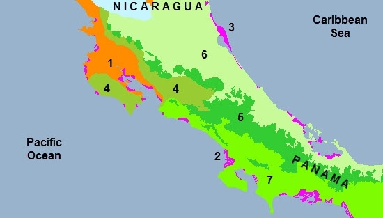
Ecoregions of Costa Rica
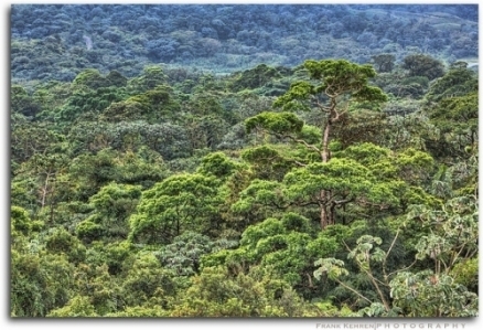
Rainforest, Arenal Volcano National Park, Costa Rica. Source: Frank Kehren
Ecoregions of Countries Collection ![]()
Costa Rica has eight ecoregions that occur entirely or partly within its borders:
- Central American dry forests
- Southern Mesoamerican Pacific mangroves (Moist Pacific Coast mangroves and Southern Dry Pacific Coast mangroves)
- Mesoamerican Gulf-Caribbean mangroves (Rio Negro-Rio San Sun mangroves)
- Costa Rican seasonal moist forests
- Talamancan montane forests
- Isthmian-Atlantic moist forests
- Isthmian-Pacific moist forestsand off shore:
- Cocos Island moist forests
While the country has only about 0.1% of the world's landmass, it contains 5% of the world's biodiversity. All of Costa Rica is included in the subtropical and tropical Mesoamerica Biodiversity Hotspot.
Contents
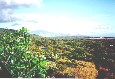
Central American dry forests
 Central American dry forest, northwest Costa Rica. Source: C.Michael Hogan The Central American dry forests is an interesting dry forest ecoregion, which stretches along the Pacific Coast, corresponds to a tropical habitat that has a prolonged dry season of five to eight months and is home to important plant and animal species, as well as a significant degree of endemism.
This totally fragmented ecoregion, represented in less than two percent of the original habitat (up to the middle of the 20th century, the ecoregion of the dry tropical forest of Central America extended in a continuous strip from the Pacific Coast of southwestern Mexico, through Guatemala, El Salvador, Honduras and Nicaragua to northwestern Costa Rica.) It is threatened by strong pressures from man, cattleovergrazing, burning, agricultural expansion, and hunting operations.
The dry tropical forests are now much more rare than tropical rain forests, although the latter are also disappearing at a very rapid rate.
Costa Rica is the country that has implemented the most conservation strategies for this ecoregion, although very little of the original habitat is protected.In 1989 the Government of Costa Rica established the Guanacaste National Park, part of the Area de Conservación Guanacaste World Heritage Site as a protected habitat in northwestern Costa Rica, This unit effectively serves as a biological corridor connecting moist forested topography on the slopes of the Orosí and Cacao Volcanoes west to the Pan-American Highway, where it joins Santa Rosa National Park. This migration corridor between the dry forest and rain forest areas allows many fauna species to move seasonally. This protected area embodies a holding of about 340square kilometers, and boasts 140 species of mammals, more than 300 bird species, 100 amphibian and reptile taxa, and over 10,000 species of insects.
This forest is affected primarily by the extraction of precious woods and many agricultural activities.
The highest priority in the ecoregion is the need for rehabilitation, formulation of management strategies including fire control and prevention, and absolute protection of the last remaining fragments, as small as they may be. If an action plan is not established according to each country’s socioeconomic and political structures, the dry forests could be wiped out completely in a short time, leaving only tiny remnants. The action plan should not only conserve but also work on the recovery of contiguous areas in the ecoregion.
Southern Mesoamerican Pacific mangroves
Within this ecoregions are two subregions in Costa Rica:
 Transition estuarine zone between mangroves and moist forest, western coastal Costa Rica. @ C.Michael Hogan The Moist Pacific Coast mangroves ecoregion runs along thepPacific coast of Central America from near the town of Jaco, Costa Rica to the southwestern corner of the Peninsula de Azuero, Panama, with a large number of embayments that provide shelter from wind and waves, favoring mangrove establishment. Tidal fluctuations also directly affect the mangrove ecosystem health. This ecoregion shows a mean tidal amplitude of 3.5 meters (m) but may range from two to six meters. Mangroves are more developed in this ecoregion than those further north due to the higher rate of freshwater inflow that reduces salt accumulation in the mangroves by increasing evapotranspiration.
A large area is protected in Costa Rica as Corcovado National Park on the Osa Peninsula. This park is also the largest tract of protected land on the Pacific side of Central America.
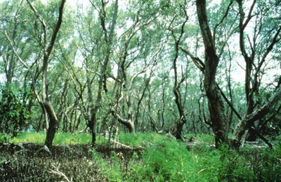 Tivives, Costa Rica (Photograph by Linda Farley) The Southern Dry Pacific Coast mangroves ecoregion runs along the Pacific coast of Central America beginning just south of the Golfo de Fonseca in Nicaragua then continuing south to the Gulf of Nicoya in Costa Rica. This southern dry pacific coast ecoregion encompasses the Gulfo de Nicoya that marks the transition zone from dry to moist on the pacific coast.
Vegetation zones can be divided into external and internal areas, and vegetation is characterized by the geneses Rhizopora and Avicennia. The ecoregion serves as an important nesting site for a number of bird species as well as providing habitat for such fauna species as mantled howler monkey, spectacled caiman, and the largest bat species in the New World, the false vampire bat. The main threat to this region is the conversion of habitat for agricultural development.
Areas with the highest remaining concentrations of mangroves in this ecoregion, in Costa Rica are Puerto Soley (near NI border; Tamarindo (400 hectares (ha)), Golfo de Nicoya (15,173 ha), and Puntarenas.
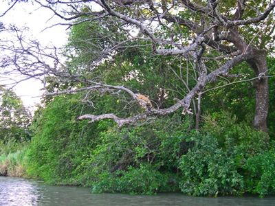
Mesoamerican Gulf-Caribbean mangroves
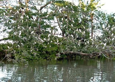
 Northern Atlantic coast, Costa Rica Photograph by Pam Cubberly Within this ecoregions are the Rio Negro-Rio San Sun mangroves which consist of a coastal ecoregion in Costa Rica, extending to the north slightly into Nicaragua and south into Panama.
Mangroves are sparse in this ecoregion, and are primarily found in estuarine lagoons and small patches at river mouths growing in association with freshwater palm species including Raphia taedigera, which has some salt tolerance and can be considered an element of mangrove forest.
These mangrove communities are also part of a mosaic of several [[habitat]s] that include mixed rainforest, wooded swamps, coastal wetlands, estuarine lagoons, sandy beaches, sea grasses, and coral reefs.
This coastal area generally consists of low alluvial floodplain (sea level to 20 meters above sea level), in which there is a network of black-water canals and creeks. In between are beaches that are important nesting areas for endangered sea turtles that feed in the seagrass beds and visit mangrove areas.
The protected areas in this region include the Tortuguero National Park and the Humedal Caribe Noreste in Costa Rica, are part of a network of Caribbean sites linked by a Meso-American Biological Corridor intended to insure continuity of biogeographical links between North and South America. The Humedal Caribe Noreste is also considered a wetland of international importance under the RAMSAR convention.
Deforestation in the upper watershed has resulted in drainage and sedimentation problems. Also associated with these problems are the acceptable management practices used on banana plantations. The redirection of surface water flow as a result of dam construction is changing the mangrove habitat by either adding or removing the natural amount of freshwater inflow to the ecoregion. A list of other threats includes land use changes as a result of unplanned settlements, illegal hunting, development of an international port, plans for another canal between the Caribbean Sea and the Pacific Ocean, gold mining on the [[Nicaragua]n] side of the border, sewage contamination from towns, runoff of agricultural chemicals, and erosion. For lack of a unified management plan, these threats appear to vary depending on the side of the border and are more acute in Costa Rica.
Costa Rican seasonal moist forests
This relatively small ecoregion lies on the [[Pacific] Ocean] slope, spanning the borders of northwestern Costa Rica and Nicaragua, between the crests of Costa Rica's central chain of volcanoes on the east and the Pacific Ocean on the west. The rain shadow created by Tilaran Mountain Range gives this ecoregion's climate significant seasonal variability.
 Parque National Rincon de la Vieja, Costa Rica Photograph by John Morrison The Costa Rican seasonal moist forests ecoregion is quite different from the surrounding dry and moist forest habitat types. Deciduous trees that lose their leaves during the distinct dry season make up the dominant vegetation in these forests. The flora are more adapted and capable of surviving in such a seasonally based ecoregion. Animals also are adapted to this fluctuation between wet and dry and the subsequent changes in the plants.
The Costa Rican seasonally moist forests have been extensively altered by human intervention. Lowland areas have been cleared for cattle, while mountain slopes, regardless of their steepness, have been cleared to grow beans, corn, coffee, as well as to support dairy cattle; most of Costa Rica's population and a significant portion of Nicaragua's lives within this ecoregion. During the past 100 years, virtually the entire ecoregion has been stripped of its native vegetation, with only small forest fragments remaining, totaling less than 10% of the ecoregion's original forest cover. The lack of lower and middle-elevation Pacific Slope forests threatens both the species that reside in these habitats and the altitudinal migrants the breed in the neighboring highlands. The small protected areas in the ecoregion total less than 30,000 hectares (ha), or around 3% of the ecoregion. In addition, this ecoregion is considered one of the least represented by National Parks within Central America.
In the past decade, there has been substantial regeneration of lower-elevation hillsides following the collapse of Costa Rica's cattle industry due to rising labor costs and decreasing yields after soils gave out from annual burning, over grazing, and resulting erosion. However, above 800 meters, the situation remains critical as a growing human population puts ever-increasing demands for living space and agricultural products that grow well in the moderate mid-elevation climate.
Talamancan montane forests
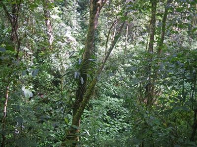 Talamancan montane forest, east slope of Volcan Baru. Source: C.Michael Hogan The Talamancan montane forests is an ecoregion situated along the mountainous spine of the Cordillera Talamanca within Costa Rica and Panama. These forests represent one of Central America’s most Intact [[habitat]s].
The steep slopes, remoteness and relatively cool temperatures have limited the impact of agriculture and human development in most of this area.
This region provides habitat for considerable floral and faunal species diversity, many of which taxa are endemic. Over 30 percent of the ecoregion's flora, including over 10,000 vascular and 4000 non-vascular plant species, are endemic to this area, as are a number of fauna species.
The Talamanca ecoregion presently retains almost 75 percent of its original forest cover, which is distributed patchily over the isolated highland zones of the Tilaran and Talamanca Ranges. The largest forest block occurs in and around the La Amistad Biosphere Reserve. Deforestation, even in the Talamancan highland oak forests, has proceeded since the 1950s at an extremely high rate. The endemic oak species are also valued for their excellent properties to produce charcoal, while rare tree species such as Podocarpus are very sensitive to exploitation.
The Talamanca montane ecoregion's high biological diversity and endemism, as well as its steep topography have encouraged the [[Costa Rica]n] and Panamanian governments to establish a series of reserves with varying degrees of protection. A full 40 percent of the ecoregion is under protection, in national parks such as the La Amistad, Chirripó, Braulio Carrillo, Volcán Poas, Volcán Baru, Rincón de la Vieja, and the Monteverde cloud forest reserve complex. Like most protected areas in Mesoamerica, the montane parks of the Talamancan forests lack full edological connectivity and regulatory oversight, and do not represent the gamut of [[ecosystem]s] needed to support altitudinal migrants. For example, they do not allow for altitudinal movement of species. Even La Amistad protects primarily highland habitats over 2000 m while largely missing Pacific slope middle and lower elevations.
However, the clearing of forest for crops and cattle pastures have begun to alter the unprotected habitat, as has timber harvesting. Because of the archipelago-like distribution of these montane patches along the Cordillera Central, beta-diversity is high between mountains and ranges, as well as along an elevational gradient.
Isthmian-Atlantic moist forests
Covering the lowland Atlantic slopes at chiefly below 500 meters (m) elevation in southern Nicaragua, northern Costa Rica, and most of (Create a New Article).html Panama (Create a New Article), the Isthmian-Atlantic moist forests represent the epitome of wet, tropical jungle. This forest ecoregion evolved from unique combinations of North American and South American flora and fauna, which came together with the joining of these continents three million years ago. Currently, much of this ecoregion has been converted to subsistence and commercial agriculture.
Although a few large blocks of intact habitat still exist, the once vast Atlantic lowland forests have been seriously fragmented in recent years. The tropical evergreen forests are among the least well represented in Costa Rica's protected areas system, although large reserves exist in southern Nicaragua and eastern Panama. Only about 130,000 (ha) in the lowland Atlantic zone are currently protected and difficult economic conditions offer little likelihood that the area in protection will be significantly expanded.
The lack of protection of the Atlantic lowlands and the heavy bias toward deforestation at elevations of < 1,000 (m) contribute to the fragmentation and elimination of these forests. With gradual slopes and relatively good access, much of Costa Rica's remaining Atlantic slope forest has been intervened or exists in small fragments. Nicaragua's lack of access and the until-recently inaccessible steeper slopes of western Panama's Atlantic lowlands and foothills have left these areas
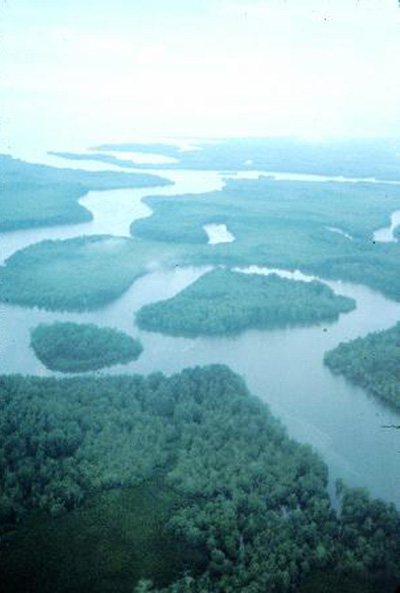
Isthmian-Pacific moist forests
 Isthmian Pacific moist forest along a coastal river, western Costa Rica. Source: C.Michael Hogan
Cocos Island moist forests
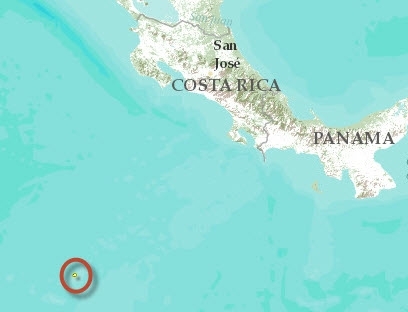 Cocos Island in the central eastern Pacific Ocean (5º32’N-86º59’W) lies 523 kilometers (km) southwest of Cabo Blanco, in Costa Rica; the country to which it has belonged since 1869, and 665 km northeast of the Galapagos Islands, in Ecuador. This small island measures 7.6 km long and 4.4 km across with a surface area of approximately 24,000 hectares (ha). There are also small islets nearby such as Dos Amigos, Rafael and Juan Bautista.
Cocos Island is the only island in the eastern Pacific with very moist tropical flora and fauna, and the only Pacific oceanic island off Central America. In addition to the very moist tropical forest, this small island has a tropical cloud forest, the highest parts of which are undisturbed, and represent the only ecosystem of this type on an eastern Pacific island. The various [[ecosystem]s] and microclimates provide numerous niches with relatively high levels of insular endemism (nearly 30% of plant species and nearly 20% of insect species). The small islands and rocks around Cocos Island and within this ecoregion also maintain important nesting colonies of migratory seabirds such as the brown booby (Sula leucogaster), red-footed booby (Sula sula), Fregata minor, Gygis alba and Anous stolidus. The high biological wealth and endemism present in the coastal and oceanic ecosystems of the island should also be noted. The island’s conservation status is good, although introduced species threaten the balance of natural processes.
The entire island was declared a National Park and Biological Reserve by the government of Costa Rica in 1978, a World Heritage Site by UNESCO in 1997 and a Wetland of International Importance. Most of the island natural habitat can be considered intact, despite the negative influence of introduced plants and animals. The low relative biodiversity and isolation of this ecoregion make it particularly vulnerable to disturbances.
Context
Ecoregions are areas that:
[1] share a large majority of their species and ecological dynamics;
[2] share similar environmental conditions; and,
[3] interact ecologically in ways that are critical for their long-term persistence.
Scientists at the World Wildlife Fund (WWF), have established a classification system that divides the world in 867 terrestrial ecoregions, 426 freshwater ecoregions and 229 marine ecoregions that reflect the distribution of a broad range of fauna and flora across the entire planet.