West Saharan montane xeric woodlands
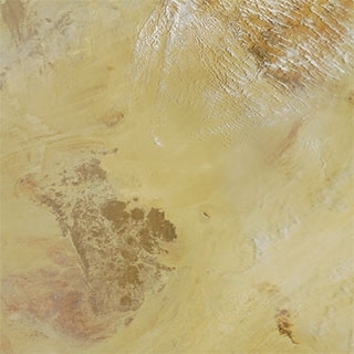
Satellite view of West Saharan montane xeric woodlands, Niger. NASA
The mountains of the West Saharan montane xeric woodlands ecoregion are found within disjunctive portions of the Sahara Desert and are predominantly of volcanic origin.
They rise from the surrounding flat desert topography, creating islands of moister habitat that support a notable relict flora and fauna. The most important area is the Tassili-n-Ajjer Plateau, an outlier of the Ahaggar Mountains in Algeria which supports relict species, some near-endemic species and some globally threatened (Endangered species) antelopes.
The human population of the ecoregion is very sparse, with less than five persons per square kilometre (km2). Because most people are nomadic, the vegetation remains fairly intact.
 Source: WWF
Location and General Description
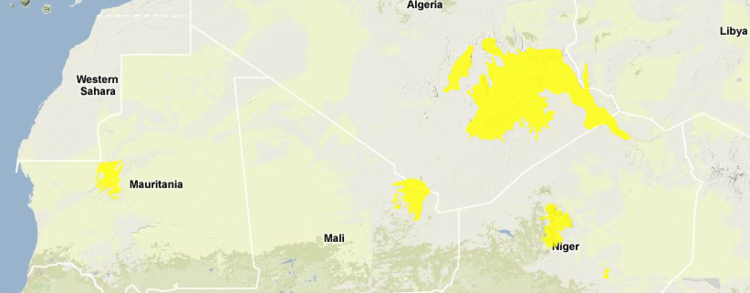
Tassili-n-Ajjer, found largely in southeastern Algeria, comprises a majority of the ecoregion. Three smaller outliers also occur, including the Air ou Azbine in northern Niger (with Monts Bagouezane reaching over 2000 metres), Dhar Adrar in Mauritania (reaching almost 700 m), and Adrar des Iforas in Mali and Algeria (reaching 900 m).
 Aoudad (Ammotragus lervia) (Photograph by Anne Carney)
 Climatically, this ecoregion is cold and dry in the winter and hot and dry in the summer. Rainfall is variable, but averages less than 100 millimetres (mm) per annum, with most falling at higher elevations. Even during the summer the ecoregion may receive precipitation at elevations above 2400 m. The mean maximum temperature reaches 30°C at the lower elevations and 18° to12°C at the highest elevations. The mean minimum temperatures are as low as 3°C at the highest elevations and as high as 15°C at the lowest elevations in the ecoregion. Frosts are common, and snow can be found on the higher peaks in the winter.
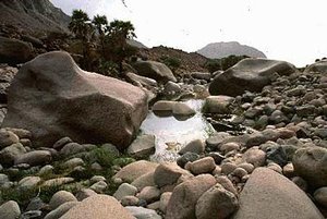
The largest part of the ecoregion, the Tassili-n-Ajjer area, is comprised of volcanic lava. The soils that developed over these deposits are mapped as a mixture of bare rock and lithosols at higher elevations, and yermosols at lower elevations. The plateau is separated into an inner and outer Tassili by a trench of clay-sandstones. Forests of wind-eroded rocks cover much of the ground. The historical alternation between wetter and drier periods, and their accompanying geomorphologic processes have led to the unique morphologic structure and steep sided valleys of the Tassili-n-Ajjer. The past wet periods also produced large lakes in the region that are today the great ergs, or vast areas of shifting sand dunes. However, for the last 10,000 to 15,000 years the whole area has become increasingly dry. Throughout the ecoregion permanent waterholes called gueltas are protected from the sun (Sunlight) in narrow gorges, which reduces evaporation and increases the viability of the pools; it is primarily these areas that give the ecoregion its flora and faunal values.
 Hoggar Mountains, Algeria (Photograph by Jeanne Tabachnick) This ecoregion is regarded as a part of the Saharan regional transition zone in White's phytogeographical classification of Africa. At lower elevations, the vegetation is mapped as regs, hamadas and wadis, but at the highest altitudes there is a transition to saharomontane vegetation. This ecoregion supports an interesting relict flora, with Mediterranean, Sudano-Deccan and Saharo-Sindien affinities. The affinities to the Mediterranean region area are particularly notable.
Vegetation within this ecoregion varies according to elevation and landscape features, and contains a number of endemic and rare species. The most notable of these is Duprey cypress, or "tarout" (Cupressus depreziana), wild olive (Olea lapperrini) and myrtle (Myrtus nivellei), all of which are relict Saharan-Mediterranean species. In particular, the Duprey cypress has only 240 individuals remaining. Olive and myrtle trees grow at the bottom of wadis, intermittent stream valleys, or beside gueltas, permanent or temporary waterholes. Other species with a preference for moist [[habitat]s] are Trianthema pentandra, Lupinus pilosus, and Convolvulus fatmensis. Silene kiliani, Acacia laeta, A. scorpiodes and Cordia rochii grow in wadis. Other representatives of the 28 national Algerian plant rarities found on Tassili-n-Ajjer include Ficus ingens and Anticharis glandulosa.
After rains, precipitation flows down channels from higher elevations into wadis that harbor water due to impermeable layers in the soil. These areas support Schouwia-Tribulus vegetation that is known for its role in the life cycle of the desert locust. The female locusts lay their eggs in the moist soil of wadis, with Schouwia-Tribulus providing food and additional moisture necessary for the maturation of the larvae. These insects are responsible for plagues, including the devastating and far reaching damage in 1980-1981 when swarms of locusts reached distant areas of Africa and even Europe, destroying numerous crop fields.
Biodiversity Features
 Tamgak Massif, Niger (Photograph by WWF/Peter Tunley)
 Comprised of landlocked mountain islands in a barren desert sea, this ecoregion is vital to the survival of many species, both resident and migratory. Migratory Palaearctic birds use this ecoregion as a rest area because of the year-around water and cooler [[temperature]s]. Waterbirds using the ecoregion include little bittern (Ixobrychus minutus), white stork (Ciconia ciconia), purple heron (Ardea purpurea), and night heron (Nycticorax nycticorax). Raptors including lesser kestrel (Falco naumanni VU), short-toed eagle (Circaetus gallicus), long-legged buzzard (Buteo rufinus), and other birds such as quail (Coturnix coturnix), wryneck (Jynx torquilla), and scops owl (Otus scops) also use this ecoregion as a stopover. Some bird species utilize the region for breeding, for example, coot (Fulica atra), moorhen (Gallinula choropus) and a relic subspecies of the Barbary partridge (Alectoris barbara duprezii) utilize these patches of suitable habitat.
The plateaus that comprise this ecoregion are biologically important, and function as integral components of the greater Sahara Desert ecosystem. It is one of the last remaining places where some mammal species are able to survive. These include [[population]s] of globally threatened antelope, such as dorcas gazelle (Gazella dorcas, VU), slender-horned gazelle (Gazella leptoceros, EN) and dama gazelle (Gazella dama, EN). The addax (Addax nasomaculatus, CR), and scimitar-horned oryx (Oryx dammah, EN) were also once found in this ecoregion but are now thought to be extinct in the wild. The Parc National de Tassili-n-Ajjer recorded the last occurrence of the scimitar-horned oryx in this ecoregion when two were discovered dead on a road outside of the park boundary in 1987. Cheetah (Acinonyx jubatus, VU), Barbary sheep (Ammotragus lervia, VU), and caracal (Felis caracal), species more closely associated with arid climates, also exist here. Locally threatened species include the rock hyrax (Procavia capensis) and the gundi (Ctenodactylus vali). Only one near-endemic mammal species is found here, the dormouse (Graphiurus olga).
Many reptiles are also present including the snakes Telescopus obtusus, Psammophis sibilians, and Roman's saw-scale viper (Echis arenicola). Amphibians include the European green toad (Bufo viridis). Two dragonfly species found here are Orthetrum ransonneti and Orthetrum sabina.
Current Status
The largest intact blocks of habitat found in Algeria lie within the huge protected areas of Ahaggar National Park and Parc National de Tassili N’Ajjer. In these areas the flora and fauna are actively protected. Tourism has become a means of income for the area, so local people have come to realize the economic importance of the animals and plants. Park managers are attempting to end poaching and woodcutting. The other portions of the ecoregion are less well protected, but their relative lack of human inhabitants may reduce threats.
Types and Severity of Threats
Much of the ecoregion is intact and protected by its inaccessible location and rugged terrain. However, pastoralism and wood collection by nomads has led to the alteration and erosion of river channels and elimination of rare vegetation. Most of the habitat blocks are intact, although naturally fragmented by geography.
With the increase in tourism and the marketing of the Tassili Najjer as a vacation spot, the [[habitat]s] of the ecoregion should be relatively safe. However, the additional wastes created by tourists and their need for resources could be detrimental to the region. Species collecting by visitors is also a concern, especially for the endangered plants such as Duprey cypress. Protected area managers will need to carefully monitor visitors and their impacts to the national parks. Further intensive use of the region for livestock grazing and agricultural settlement will continue to degrade and alter the habitat. Motorized sport hunting from North Africa and the Middle East in combination with local subsistence hunting poses another threat to populations of a number of large mammals, such as cheetah, slender-horned gazelle, and dama gazelle.
Justification of Ecoregion Delineation
The boundaries for the largest part of this ecoregion, which includes the Tassili-n-Ajjer Ahaggar and Air ou Azbine massifs, follow the ‘regs, hamadas and wadis’, and the ‘Sarharomontane’ vegetation units of White above the 1,000 m contour. Additional areas further south were included within this ecoregion, including the Air ou Azbine in northern Niger, Dhar Adrar in Mauritania, and Adrar des Iforas in Mali and [[Algeria], using the 500 m-elevation contour.
Additional Information on this Ecoregion
- For a terser summary of this entry, see the WWF WildWorld profile of this ecoregion.
- Boitani, L. 1999. A Databank for the Conservation and Management of the African Mammals. Istituto Ecologia Applicata, Rome, Italy.
- Cloudsley-Thompson, J.L. 1984. Key Environments: Sahara Desert. Pergamon Press, Elmsford, New York. ISBN: 0080288693
- Davis, S.D., V.H. Heywood and A.C. Hamilton, editors. 1994. Centres of Plant Diversity. A Guide and Strategy for their Conservation. Volume 1. Europe, Africa, South West Asia and the Middle East. IUCN Publications Unit, Cambridge, U.K. 354 pp.
- East, R. 1999. African Antelope Database 1998. IUCN/SSC Antelope Specialist Group. IUCN, Gland, Switzerland and Cambridge, UK. ISBN: 2831704774
- Hilton-Taylor, C. 2000. The IUCN 2000 Red List of Threatened Species. IUCN, Gland, Switzerland and Cambridge, United Kingdom. ISBN: 2831705657
- Schleich, H.H., W. Kastle, and K. Kabish. 1996. Amphibians and reptiles of North Africa: biology, systematics, field guide. Koeltz Scientific Books, Germany. ISBN: 3874293777
- WCMC 2000a. Data Sheet on Parc National de Tassili N’Ajjer.
- WCMC 2000b. Data Sheet on Ahaggar National Park.
- White, F. 1983. The vegetation of Africa, a descriptive memoir to accompany the UNESCO/AETFAT/UNSO Vegetation Map of Africa (3 Plates, Northwestern Africa, Northeastern Africa, and Southern Africa, 1:5,000,000). UNESCO, Paris. ISBN: 9231019554
- WWF and IUCN. 1994. Davis, S.D., V.H. Heywood, and A.C. Hamilton. editors. 1994. Centres of plant diversity. Vol 1: Europe, Africa, Southwest Asia and the Middle East. Oxford, UK. ISBN: 283170197X
| Disclaimer: This taken contains information that was originally published by the World Wildlife Fund. Topic editors and authors for the Encyclopedia of Earth have edited its content and added new information. The use of information from the World Wildlife Fund should not be construed as support for or endorsement by that organization for any new information added by EoE personnel, or for any editing of the original content. |